
The Geostationary Earth Radiation Budget (GERB) is an instrument aboard EUMETSAT's Meteosat Second Generation geostationary satellites designed to make accurate measurements of the Earth radiation budget.

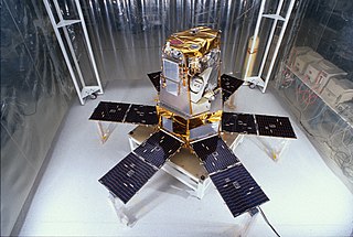
Terra is a multi-national, NASA scientific research satellite in a Sun-synchronous orbit around the Earth that takes simultaneous measurements of Earth's atmosphere, land, and water to understand how Earth is changing and to identify the consequences for life on Earth. It is the flagship of the Earth Observing System (EOS) and the first satellite of the system which was followed by Aqua and Aura. Terra was launched in 1999.

Clouds and the Earth's Radiant Energy System (CERES) is an on-going NASA climatological experiment from Earth orbit. The CERES are scientific satellite instruments, part of the NASA's Earth Observing System (EOS), designed to measure both solar-reflected and Earth-emitted radiation from the top of the atmosphere (TOA) to the Earth's surface. Cloud properties are determined using simultaneous measurements by other EOS instruments such as the Moderate Resolution Imaging Spectroradiometer (MODIS). Results from the CERES and other NASA missions, such as the Earth Radiation Budget Experiment (ERBE), could enable nearer to real-time tracking of Earth's energy imbalance (EEI) and better understanding of the role of clouds in global climate change.
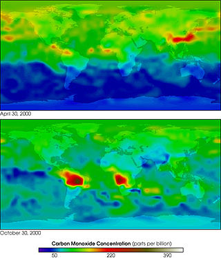
MOPITT is an ongoing astronomical instrument aboard NASA's Terra satellite that measures global tropospheric carbon monoxide levels. It is part of NASA's Earth Observing System (EOS), and combined with the other payload remote sensors on the Terra satellite, the spacecraft monitors the Earth's environment and climate changes. Following its construction in Canada, MOPITT was launched into Earth's orbit in 1999 and utilizes gas correlation spectroscopy to measure the presence of different gases in the troposphere. The fundamental operations occur in its optical system composed of two optical tables holding the bulk of the apparatus. Results from the MOPITT enable scientists to better understand carbon monoxide's effects on a global scale, and various studies have been conducted based on MOPITT's measurements.
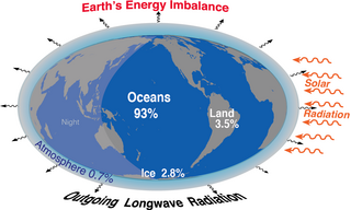
Earth's energy budget accounts for the balance between the energy that Earth receives from the Sun and the energy the Earth loses back into outer space. Smaller energy sources, such as Earth's internal heat, are taken into consideration, but make a tiny contribution compared to solar energy. The energy budget also accounts for how energy moves through the climate system. Because the Sun heats the equatorial tropics more than the polar regions, received solar irradiance is unevenly distributed. As the energy seeks equilibrium across the planet, it drives interactions in Earth's climate system, i.e., Earth's water, ice, atmosphere, rocky crust, and all living things. The result is Earth's climate.
The Solar Radiation and Climate Experiment (SORCE) was a NASA-sponsored satellite mission that measured incoming X-ray, ultraviolet, visible, near-infrared, and total solar radiation. These measurements specifically addressed long-term climate change, natural variability, atmospheric ozone, and UV-B radiation, enhancing climate prediction. These measurements are critical to studies of the Sun, its effect on the Earth's system, and its influence on humankind. SORCE was launched on 25 January 2003 on a Pegasus XL launch vehicle to provide NASA's Earth Science Enterprise (ESE) with precise measurements of solar radiation.
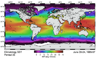
The Advanced Very-High-Resolution Radiometer (AVHRR) instrument is a space-borne sensor that measures the reflectance of the Earth in five spectral bands that are relatively wide by today's standards. AVHRR instruments are or have been carried by the National Oceanic and Atmospheric Administration (NOAA) family of polar orbiting platforms (POES) and European MetOp satellites. The instrument scans several channels; two are centered on the red (0.6 micrometres) and near-infrared (0.9 micrometres) regions, a third one is located around 3.5 micrometres, and another two the thermal radiation emitted by the planet, around 11 and 12 micrometres.
The atmospheric infrared sounder (AIRS) is one of six instruments flying on board NASA's Aqua satellite, launched on May 4, 2002. The instrument is designed to support climate research and improve weather forecasting.
The International Satellite Cloud Climatology Project (ISCCP) was established as the first project of the World Climate Research Program (WCRP). Since its inception in 1982, there have been two phases, 1983–1995 and 1995–2009. The project is responsible for collection and analysis of weather satellite radiance measurements. It infers clouds' global distribution and properties, along with their diurnal, seasonal, and interannual variations. The results are studied to understand clouds in climate, including their effects on radiative energy exchanges, plus their role in the global water cycle. These datasets provide a systematic view of cloud behavior.

Soil Moisture Active Passive (SMAP) is a NASA environmental monitoring satellite that measures soil moisture across the planet. It is designed to collect a global 'snapshot' of soil moisture every 2 to 3 days. With this frequency, changes from specific storms can be measured while also assessing impacts across seasons of the year. SMAP was launched on 31 January 2015. It was one of the first Earth observation satellites developed by NASA in response to the National Research Council's Decadal Survey.
Robert Donald Cess was a professor of atmospheric sciences at Stony Brook University. He was born in Portland, Oregon. Cess earned his bachelor of science degree in mechanical engineering from Oregon State University and his master's degree from Purdue University in Indiana in 1956. He received a Ph.D. from the University of Pittsburgh in 1959. He is a recognized leader in the fields of climate change and atmospheric radiation transfer. His research interests involve modeling of climate feedbacks that can either amplify or diminish global climate change, and interpreting surface and satellite remote sensing data.

Miguel Román, serves as Chief Climate Scientist and Technical Fellow at Leidos. A leading expert in the fields of satellite remote sensing, climate change, disaster risk reduction, and sustainability, Román has championed translational research and data-intensive approaches to assess and address climate-related risks. His work is internationally recognized for shedding light on the disproportionate hardships experienced by socially-vulnerable and underserved communities following major disasters.

The Joint Polar Satellite System (JPSS) is the latest generation of U.S. polar-orbiting, non-geosynchronous, environmental satellites. JPSS will provide the global environmental data used in numerical weather prediction models for forecasts, and scientific data used for climate monitoring. JPSS will aid in fulfilling the mission of the U.S. National Oceanic and Atmospheric Administration (NOAA), an agency of the Department of Commerce. Data and imagery obtained from the JPSS will increase timeliness and accuracy of public warnings and forecasts of climate and weather events, thus reducing the potential loss of human life and property and advancing the national economy. The JPSS is developed by the National Aeronautics and Space Administration (NASA) for the National Oceanic and Atmospheric Administration (NOAA), who is responsible for operation of JPSS. Three to five satellites are planned for the JPSS constellation of satellites. JPSS satellites will be flown, and the scientific data from JPSS will be processed, by the JPSS – Common Ground System (JPSS-CGS).

The Suomi National Polar-orbiting Partnership, previously known as the National Polar-orbiting Operational Environmental Satellite System Preparatory Project (NPP) and NPP-Bridge, is a weather satellite operated by the United States National Oceanic and Atmospheric Administration (NOAA). It was launched in 2011 and is currently in operation.

CLARREO is a high-priority NASA decadal survey mission, originally selected as such by the National Research Council in 2007. The CLARREO mission is intended to provide a metrology laboratory in orbit to accurately quantify and attribute Earth's climate change. The mission is also designed to transfer its high accuracy to other spaceborne sensors. It would serve as a reference calibration standard in orbit, making climate trends apparent in their data sets by 2055, within a 30-year time frame after its planned launch in the 2020s. These measurements may go on to enable testing, validation, and improvement of climate model prediction.

The Visible Infrared Imaging Radiometer Suite (VIIRS) is a sensor designed and manufactured by the Raytheon Company on board the polar-orbiting Suomi National Polar-orbiting Partnership, NOAA-20, and NOAA-21 weather satellites. VIIRS is one of five key instruments onboard Suomi NPP, launched on October 28, 2011. VIIRS is a whiskbroom scanner radiometer that collects imagery and radiometric measurements of the land, atmosphere, cryosphere, and oceans in the visible and infrared bands of the electromagnetic spectrum.

Plankton, Aerosol, Cloud, ocean Ecosystem (PACE) is a NASA Earth-observing satellite mission that will continue and advance observations of global ocean color, biogeochemistry, and ecology, as well as the carbon cycle, aerosols and clouds. PACE will be used to identify the extent and duration of phytoplankton blooms and improve understanding of air quality. These and other uses of PACE data will benefit the economy and society, especially sectors that rely on water quality, fisheries and food security.

Graeme Leslie Stephens is director of the center for climate sciences at the NASA Jet Propulsion Laboratory at the California Institute of Technology and professor of earth observation the University of Reading.
NOAA-10, known as NOAA-G before launch, was an American weather satellite operated by the National Oceanic and Atmospheric Administration (NOAA) for use in the National Environmental Satellite Data and Information Service (NESDIS). It was the third of the Advanced TIROS-N series of satellites. The satellite design provided an economical and stable Sun-synchronous platform for advanced operational instruments to measure the atmosphere of Earth, its surface and cloud cover, and the near-space environment.
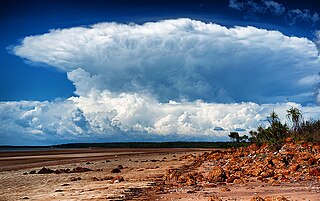
Fixed anvil temperature hypothesis is a physical hypothesis that describes the response of cloud radiative properties to rising surface temperatures. It presumes that the temperature at which radiation is emitted by anvil clouds is constrained by radiative processes and thus does not change in response to surface warming. Since the amount of radiation emitted by clouds is a function of their temperature, it implies that it does not increase with surface warming and thus a warmer surface does not increase radiation emissions by cloud tops. The mechanism has been identified both in climate models and observations of cloud behaviour, it affects how much the world heats up for each extra tonne of greenhouse gas in the atmosphere. However, some evidence suggests that it may be more correctly formulated as decreased anvil warming rather than no anvil warming.
