
The Akosombo Dam, also known as the Volta Dam, is a hydroelectric dam on the Volta River in southeastern Ghana in the Akosombo gorge and part of the Volta River Authority. The construction of the dam flooded part of the Volta River Basin and led to the subsequent creation of Lake Volta. Lake Volta is the largest man-made lake in the world by surface area. It covers 8,502 square kilometres (3,283 sq mi), which is 3.6% of Ghana's land area. With a volume of 148 cubic kilometers, Lake Volta is the world's third largest man-made lake by volume; the largest being Lake Kariba which contains 185 cubic kilometers of water.

The Souris River or Mouse River is a river in central North America. Approximately 435 miles (700 km) in length, it drains about 23,600 square miles (61,100 km2) in Canada and the United States.
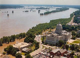
The Great Flood of 1993 was a flood that occurred in the Midwestern United States, along the Mississippi and Missouri rivers and their tributaries, from April to October 1993.

Benue River, previously known as the Chadda River or Tchadda, is the major tributary of the Niger River, with a length of approximately 1,400 kilometres (870 mi) long and almost entirely navigable during the summer months. The size of its catchment basin is 319,000 km2 (123,000 sq mi). As a result, it is an important transportation route in the regions through which it flows. The name Benue comes from Binuwe meaning 'Mother of Waters’ in the Batta language.

The River Bandon is a river in County Cork, Ireland.
Stoke is a civil parish on the Hoo Peninsula in Kent, England, to the south of Allhallows, on the north of the Medway Estuary. The parish had a population of 1,060 at the 2011 census.

Franks Tract State Recreation Area (SRA) is a state park unit of California, United States, featuring a flooded area in the Sacramento–San Joaquin River Delta. It is accessible only by water. Franks Tract, and a smaller adjoining submerged property called "Little Franks Tract", are situated between the False River and Bethel Island. The recreation area is used primarily for fishing and waterfowl hunting, because of its exposure to frequent strong winds and fluctuating water levels. In times of high water, the entire site can be submerged except for portions of the old levees. The 3,523-acre (1,426 ha) park was established in 1959. It is managed from nearby Brannan Island State Recreation Area, 6 miles (9.7 km) to the northwest.

Bruzolo ) is a comune of the Metropolitan City of Turin in the Italian region Piedmont. Located some 43 kilometres (27 mi) west of Turin, in the lower Susa Valley, it is a member of the Comunità Montana Bassa Valle di Susa e Val Cenischia. Bruzolo borders the following municipalities: Usseglio, Condove, Chianocco, San Didero, and San Giorio di Susa.
Kobo or Raya Kobo is a woreda in the Amhara Region of Ethiopia. Located in the northeast corner of the North Wollo Zone, Kobo is bordered on the south by the Logiya River which separates it from Habru and Guba Lafto, on the west by Gidan, on the north by Tigray Region, and on the east by the Afar Region. Towns in Kobo include Gobiye, Kobo and Robit.

Steven Tilley is a former Speaker of the Missouri House of Representatives. He represented District 106 in the Missouri House of Representatives. A Republican, Tilley was elected to the House in November 2004. He became the Majority leader in January 2008. On August 13, 2012 Tilley resigned from the Missouri House of Representatives.

Ceiriog Ucha, also spelled as Ceiriog Uchaf, is a community in Wrexham County Borough, Wales. The community lies in the Ceiriog Valley and comprises the villages of Llanarmon Dyffryn Ceiriog and Tregeiriog as well as surrounding farmland and grouse and pheasant moors. It is a rural district set in low hills. The area is governed by Ceiriog Uchaf Community Council, and had a total population of 346, in 129 households, at the 2001 census. reducing to 317 in 2011.

Shimpling is a village and civil parish in south Suffolk, England. About 7 miles (11 km) from Bury St Edmunds, it is part of Babergh district. The village is formed from two halves, the newer Shimpling Street and about 2 miles (3 km) away the old village of Shimpling. The village has a Church of England parish church, where supermodel Claudia Schiffer and film producer Matthew Vaughn were married on 25 May 2002.
Chol Kiri is a district (srok) in the east of Kampong Chhnang province, in central Cambodia. The district capital is Chol Kiri town located around eight km (5.0 mi) south of the provincial capital of Kampong Chhnang by road. Chol Kiri district is the easternmost district of Kampong Chhnang. The district shares a border with Kampong Thom and Kampong Cham provinces to the east. Most of the district is low lying floodplain and the Tonlé Sap river runs through the district roughly from north to south. This proximity to the river and the lack of high land make Chol Kiri one of the most flood prone districts in the country. The Kampong Chhnang Department of Development has estimated that both Chol Kiri and Kampong Leaeng districts are flooded for six months of the year and that after the floodwaters have receded drinking water sources are left contaminated.
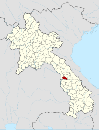
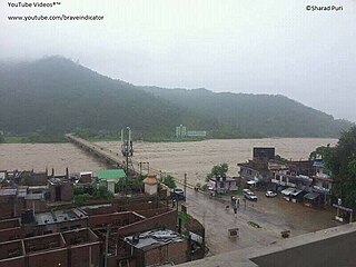
Sebangphay or Xebangfay is a district (muang) of Khammouane province in mid-Laos. The district was badly affected by floods caused by heavy rain in July 2011, affecting rice farmland in the district, inundating over 200 hectares. Floods occurred also in August 2014.
The Kundu River also known as Kunderu, Kumudvathi is a tributary of the Penna River in the Rayalaseema region of Andhra Pradesh, India. Originating as a spring near the village of Uppalapadu in Orvakal Mandal of Kurnool District, it goes through many changes before merging with the Penna at kamalapuram of Kadapa District. It is known for frequent floods that bring heavy damage to the Nandyal and Koilkuntla areas, and hence it is popularly called the "Sorrow of Nandyal." But nowadays Nandyal town became a big town with huge population so that the drainage water is discharged to the Kundu river without prior treatment. Industrialists focused their vision at more and more profits and they polluted the river to the maximum extent. The villagers who are living at down flow of the river from Nandyala are suffering with different skin diseases. The pollution impacts even animals health too. In ancient times this river was known as the Kumudvathi. There is a saying in Rayalaseema that whoever drinks the water of the Kundu will gain enormous courage to face enemies. The valley of the Kundu is known as Renadu and is symbolic of the term "Renati Pourusham."
West Rapti, also known as the Kuwano, is a river which drains Rapti Zone in Mid-Western Region, Nepal, then Awadh and Purvanchal regions of Uttar Pradesh state, and finally India before joining the Ghaghara. It is a major left bank tributary of the Ganges, and is also known as the Karnali inside Nepal.

The Najafgarh drain or Najafgarh nalah, which also acts as Najafgarh drain bird sanctuary, is another name for the northernmost end of River Sahibi, which continues its flow through Delhi, where it is channelized, and then flows into the Yamuna. Within Delhi, due to its channelization for flood control purposes, it is now erroneously called "Najafgarh drain" or "Najafgarh nullah." It gets this name from the once famous and huge Najafgarh Jheel (lake) near the town of Najafgarh in southwest Delhi and within urbanized Delhi. It is the Indian capital’s most polluted water body due to direct inflow of untreated sewage from surrounding populated areas. A January 2005 report by the Central Pollution Control Board classifies this drain, with 13 other highly polluted wetlands, under category ‘‘D’’ for assessing the water quality of wetlands in wildlife habitats.
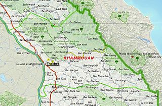
Khammouane province (Khammouan) is a province in the center of Laos. Its capital lies at Thakhek.
The North Jiangsu Main Irrigation Canal is located in the lower reaches of the Huai River, one of the major rivers in the north of Jiangsu Province, China. It originates at Gaoliangjian on Hongze Lake and runs through Hongze, Qingpu, Huai'an, Funing, Sheyang and Binghai county(or district) and joins the artificial estuary of Biandan Harbour. The canal is 168 km in length and can irrigate 1,720,000 hectares of farmland. The construction program was organized and directed by the headquarters of the Jiangsu Huai River management program between October 1951 and May 1952.
