
St. Lawrence is a neighbourhood located in downtown Toronto, Ontario, Canada. The area, a former industrial area, is bounded by Yonge, Front, and Parliament Streets, and the Canadian National railway embankment. The Esplanade off Yonge St., lined with restaurants, cafés and hotels runs through the middle of the area. In previous times, the area was sometimes referred to as 'St. Lawrence Ward' or more often today as 'St. Lawrence Market', synonymous with the large retail vendor market which is the neighbourhood's focal point. The area is the site of a large city-sponsored housing project of the 1970s, which revitalized an old brownfields area. The boundaries of the St Lawrence Neighbourhood Association and the St Lawrence Market BIA are somewhat larger than those noted above. Both groups have boundaries that extend from Yonge to Parliament Streets and Queen Street East to the rail corridor.

Harbourfront is a neighbourhood on the northern shore of Lake Ontario within downtown Toronto, Ontario, Canada. Part of the Toronto waterfront, Harbourfront extends from Bathurst Street in the west, along Queens Quay, with its ill-defined eastern boundary being either Yonge Street or York Street. Its northern boundary is the Gardiner Expressway. Much of the district was former water lots filled in during the early 1900s to create a larger harbour district. After shipping patterns changed and the use of the Toronto Harbour declined, the area was converted from industrial uses to a mixed-use district that is mostly residential and leisure.
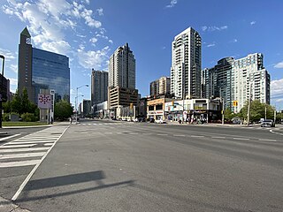
North York City Centre is a central business district in Toronto, Ontario, Canada in the administrative district of North York. It is located along Yonge Street, between just south of Sheppard Avenue northward to Finch Avenue with its focus around Mel Lastman Square, a civic square, and spreads eastwards and westwards a few blocks, generally as far as Doris Avenue and Beecroft Road. The district is a high-density district of condominium and office towers with ground-floor commercial uses along the wide six lanes of Yonge Street.
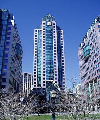
Metro Hall is a 27-storey Postmodern-style office tower at the corner of Wellington and John Street in the downtown core of Toronto, Ontario, Canada. It looks out onto Pecaut Square. Part of the three-tower Metro Centre complex, the building was completed in 1992 to house the Municipality of Metropolitan Toronto (Metro) and its employees. The building is now used by the City of Toronto following municipal consolidation in 1998.

Government House was the official residence of the lieutenant governor of Upper Canada and Ontario, Canada. Four buildings were used for this purpose, none of which exist today, making Ontario one of four provinces not to have an official vice-regal residence.

The Etobicoke Civic Centre in the Eatonville neighbourhood of Toronto, Ontario, Canada, once housed the municipal government of the former City of Etobicoke.

The East York Civic Centre was the municipal office of the former borough of East York, now part of Toronto, Ontario, Canada as the result of municipal amalgamation. The two-storey civic buildings, located on the western side of Coxwell Avenue, were completed in 1990. Prior to 1990 it was the site of the East York Municipal Offices built in 1948, additions added in 1963 and 1975. The Township of East York Municipal Building was located nearby at 443 Sammon Avenue.

North York City Centre is an office tower complex in Toronto, Ontario, Canada. Completed in 1989, it is home to the North York Central Library, secondary offices of the City of Toronto government, and other corporate headquarters.
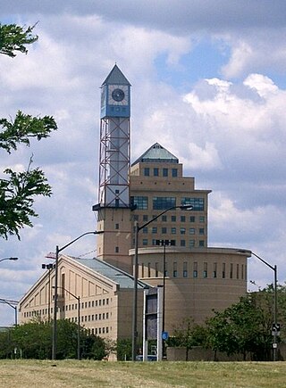
The Mississauga Civic Centre is the seat of local government of Mississauga, Ontario, Canada. The 37,280 square metre complex is a prominent example of postmodern architecture in Canada, finished in 1987 by Jones and Kirkland. It stands at 92 metres or 302 feet. The design was influenced by farmsteads which once occupied much of Mississauga as well as historical features of city centres. The building, for instance, includes a prominent clock tower. It was chosen as the winner of a design competition that included 246 submissions. Mississauga Civic Centre is located in the City Centre near Square One Shopping Centre and is home to the Mississauga City Council. The civic center building is considered one of the most iconic and recognizable buildings and cultural icons of Mississauga city.

The Workmen's Compensation Board Building was a five-storey office building in Toronto, Ontario. It was originally home to the Workers Compensation Board of Ontario from 1953 to 1973. It was designed by the province's master architect, George N. William.
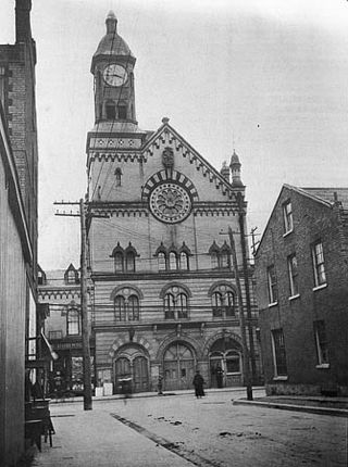
Yorkville Town Hall was the municipal building for the Village of Yorkville before its annexation by the City of Toronto. Built in 1859-1860 by architect William Hay and his apprentice Henry Langley, the three-storey building also served as an omnibus stop. The hall was located north of Bloor Street on Yonge Street, along the west side.

Earlscourt is a neighbourhood in Toronto, Ontario, Canada. It is centred on St. Clair Avenue West, with Dufferin Street, Davenport Road, and Old Weston Road forming its boundaries. It is contained within the larger city-recognized neighbourhood of Corso Italia-Davenport.
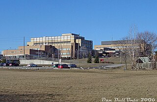
Peel Memorial Hospital (PMH) was a 367-bed acute care hospital located in central Brampton, Ontario. PMH was founded in 1925 and became a part of the William Osler Health Centre in 1998. It previously served approximately 400,000 residents in Brampton and the surrounding areas. Over 96,832 patients were treated on an out-patient basis, another 70,446 residents used the 24/7 emergency department and 22,889 patients were admitted for inpatient care. The hospital employed over 1,800 professional and support personnel. There were 320 physicians as well as approximately 600 volunteers that contributed their services and fund raising efforts.

The Herb Carnegie Centennial Centre, formerly named the North York Centennial Centre, is a multi-purpose arena in Toronto, Ontario, Canada. It was built in 1966 and occasionally hosted the Toronto Marlboros of the Ontario Hockey League. It was renamed on May 2, 2001 for Herb Carnegie, a black Canadian ice hockey pioneer. This arena hosts the North York Rangers of the Ontario Junior Hockey League team. The arena also offers leisure skating organized by the City of Toronto government. It is situated at Finch Avenue and Bathurst Street in the district of North York. It is located next to the Centennial Library, a branch of Toronto Public Library. During the summer, the arena's ice surface is converted into a dry pad for sports like lacrosse..

Downtown Toronto is the main city centre of Toronto, Ontario, Canada. Located entirely within the district of Old Toronto, it is approximately 16.6 square kilometres in area, bounded by Bloor Street to the northeast and Dupont Street to the northwest, Lake Ontario to the south, the Don Valley to the east, and Bathurst Street to the west. It is also the home of the municipal government of Toronto and the Government of Ontario.
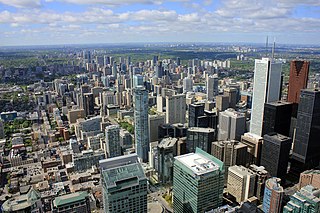
Midtown is one of four central business districts outside the city's downtown core of Toronto, Ontario, Canada. Located in the north of Old Toronto, its borders are roughly defined by St. Clair Avenue to the south and Eglinton Avenue or Lawrence Avenue to the north, Bayview Avenue to the east and Dufferin Street to the west. The central neighbourhood of the area is Yonge–Eglinton.

The Markham Civic Centre is the city hall of the city of Markham, Ontario. The brick and glass Civic Centre was designed by architect Arthur Erickson with Richard Stevens Architects Limited and was opened on May 25, 1990. The entrances, except for the great hall entrance, are named after communities in Markham. The building is adjacent to an 11.5-hectare park with a large pond reflecting the south façade.
Ebenezer is a former hamlet in Brampton, in Ontario's Regional Municipality of Peel. In recent years, the locality has undergone considerable residential development.

The Bloor Street Culture Corridor is a cluster of arts and cultural organizations in Toronto, Ontario, Canada. It is located on Bloor Street West, between Bathurst and Yonge streets.

The Broadway Theatre was a burlesque live theatre and cinema in Toronto, Ontario, Canada. The theatre was opened under the name of Globe Theatre, in 1918. It was renamed the Roxy Theatre in the early 1930s and assumed its final name, the Broadway Theatre, in 1937. It was located on the southwest corner of Bay and Queen streets at 75 Queen Street West.


