
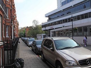
St James's is a central district in the City of Westminster, London, forming part of the West End. The area was once part of the northwestern gardens and parks of St. James's Palace. During the Restoration in the 17th century, the area was developed as a residential location for the British aristocracy, and around the 19th century was the focus of the development of their gentlemen's clubs. Once part of the parish of St Martin in the Fields, much of it formed the parish of St James from 1685 to 1922. Since the Second World War the area has transitioned from residential to commercial use.

Adelphi is a district of the City of Westminster in London. The small district includes the streets of Adelphi Terrace, Robert Street and John Adam Street. Of rare use colloquially, Adelphi is grouped with Aldwych as the greater Strand district which for many decades formed a parliamentary constituency and civil registration district.
Luxborough Street, formerly Northumberland Street, is a street in the City of Westminster, London, that runs from Marylebone Road in the north to Paddington Street in the south. Nottingham Street joins Luxborough Street on its eastern side.
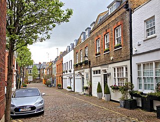
Devonshire Close, originally known as Devonshire Mews East, is a mews street in the City of Westminster, London, accessed from Devonshire Street. The Close is on a distinctive H plan with a middle downwards leg. It dates from the 1770s and originally contained a timber yard, stables, and accommodation for domestic servants who worked in the larger houses surrounding it. Access was limited to the north side in order to divert traffic from the grander north–south streets around it. The Close was gentrified in the 20th century and its buildings converted to mews houses which, like other mews in London, have become desirable in the modern era because they are quiet and have little traffic. The Close is now part of the Howard de Walden Estate.
This is a list of the etymology of street names in the London district of Marylebone. The following utilises the generally accepted boundaries of Marylebone viz. Marylebone Road to the north, Great Portland Street to the east, Marble Arch and Oxford Street to the south and Edgware Road to the west.
This is a list of the etymology of street names in the area of Regent's Park in London ; the area has no formal boundaries, though it generally thought to be delimited by Prince Albert Road to the north, Park Village East and Hampstead Road/the Euston railway line/Eversholt Street to the east, Euston Road and Marylebone Road to the south and Park Road and Baker Street to the west.

Gloucester Place is a street in Marylebone in Central London. Located in the City of Westminster, it runs north from Portman Square across the Marylebone Road eventually merging into Park Road. It is parallel to Baker Street to the east and forms part of the A41 road from nearby Marble Arch.

Church Street is a thoroughfare in Marylebone, located in West London, and is within the West End of London. Located in the City of Westminster, it runs from Lisson Grove on a south west diagonal crossing Edgware Road and finishing at Paddington Green and the nearby St Mary's Church, from which the street gets its name. The Church Street electoral ward is named after the street.

George Street is a street in Marylebone in Central London, England. Located in the City of Westminster, it runs east from Edgware Road until it reaches Marylebone High Street at its junction with Thayer Street. It crosses a number of streets including Seymour Place, Gloucester Place, Manchester Street and Baker Street.

Gloucester Terrace is a street in Central London in the vicinity of Paddington and Bayswater. Located in the City of Westminster, it runs northwards from Lancaster Terrace near to Lancaster Gate tube station and Hyde Park before curving round to meet Porchester Square around Westbourne. The southern section is close to the border between Tyburnia and Bayswater. It intersects with Craven Road, Chilworth Street, Cleveland Terrace, Bishop's Bridge Road and Orsett Terrace. Its northern section is close to the Great Western Main Line and Westway. Westbourne Terrace runs directly parallel to the east.
Abercorn Place is a street in St John's Wood in London. Located in the City of Westminster, it runs west to east from the Edgware Road at Maida Vale until it joins Abbey Road not far from the Abbey Road Studios to the south. It is crossed by Hamilton Terrace. The street is named after the Duke of Abercorn, an Anglo-Irish aristocrat. It was part of an estate originally owned by Harrow School of which Abercorn was a governor with other nearby streets similarly named. The street contains a mixture of housing from the 1820s onwards. Several buildings in the street are listed today. The Anglican St Mark's Church was built in 1847 at the intersection with Hamilton Terrace. It was designed in the Gothic style by the architect Thomas Cundy.
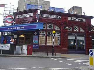
Randolph Avenue is a street in Maida Vale in London. Located in the City of Westminster, it is a long avenue running from north to south. The southern end is located in Little Venice near to the Paddington branch of the Grand Union Canal. The street runs northwards, crossing Clifton Gardens, Sutherland Avenue, Elgin Avenue and Carlton Vale. The road then continues as Randolph Gardens until it meets Kilburn Park Road. The Edgware Road runs directly parallel to Randolph Avenue to the east.

Warrington Crescent is a street in Maida Vale in London. Located in the City of Westminster, it is a crescent curving north eastwards from Warwick Avenue until it reaches a roundabout where it meets including Randolph Avenue, Sutherland Avenue and Lauderdale Road. Warrington Gardens and Formosa Street both lead westwards off Warrington Crescent.
Sutherland Avenue is a street in Maida Vale in London, England. Located in the City of Westminster on the northern edge of Little Venice. it is an avenue running east to west from the Edgware Road to Harrow Road. Along the route it is crossed or joined by Randolph Avenue, Warrington Crescent, Lauderdale Road, Castellian Road, Warwick Avenue and Shirland Road. Elgin Avenue runs directly parallel to the north.

Gloucester Avenue is a street in the Primrose Hill area of London, England. Located in the London Borough of Camden, it is a residential road featuring many nineteenth century properties including several pubs as well as the neo-Georgian Cecil Sharp House. For much of its route it runs adjacent to the West Coast Main Line out of Euston Station.

Chiltern Street is a road in the Marylebone area of Central London. Located in the City of Westminster, it runs north to south connecting Marylebone Road and Blandford Street. Baker Street runs parallel a little way to the west. It meets Dorset Street, Crawford Street and Paddington Street along its route. Manchester Square is located beyond the southern end of the street.

Connaught Street is a street in Central London. Located in the City of Westminster, it is part of the Tyburnia area of Paddington north of Hyde Park. It runs west to east from Hyde Park Square to the Edgware Road. It continues eastwards becoming Upper Berkeley Street in Marylebone. The street contains a mixture of commercial and residential properties, forming part of Connaught Village. Connaught Square and Albion Street are located on its southern side. The Duke of Kendal public house sits at the junction between Connaught Street and Kendal Street.

Albion Street is a residential street located in Central London in the City of Westminster. Part of the Tyburnia area, it runs southwards from Connaught Street to the Bayswater Road on the edge of Hyde Park. It is notable for its Regency architecture.

Belsize Lane is a street in the Belsize Park area of Hampstead in London. Located in the London Borough of Camden, it runs east to west from Haverstock Hill to Fitzjohns Avenue. While residential for much of the route, it also features a group of commercial properties that form the centre of Belsize Village. The Tavistock Clinic is located at its western end.

Pond Street is located in Hampstead in the London Borough of Camden. It runs eastwards from Rosslyn Hill to South End Green, located in the old "South End" of the settlement. The street takes its name from an ancient pond at South End Green, a source of the River Fleet, and has been known by this name since at least 1678. The pond survived into the Victorian era.


