
The West End of London is a district of Central London, London, England, west of the City of London and north of the River Thames, in which many of the city's major tourist attractions, shops, businesses, government buildings and entertainment venues, including West End theatres, are concentrated.

Paddington is an area in the City of Westminster, in central London, England. A medieval parish then a metropolitan borough, it was integrated with Westminster and Greater London in 1965. Paddington station, designed by the engineer Isambard Kingdom Brunel opened in 1847. It is also the site of St Mary's Hospital and the former Paddington Green Police Station.

Euston Road is a road in Central London that runs from Marylebone Road to King's Cross. The route is part of the London Inner Ring Road and forms part of the London congestion charge zone boundary. It is named after Euston Hall, the family seat of the Dukes of Grafton, who had become major property owners in the area during the mid-19th century.

The Metropolitan Borough of St Marylebone was a metropolitan borough of the County of London from 1900 to 1965. It was based directly on the previously existing civil parish of St Marylebone, Middlesex, which was incorporated into the Metropolitan Board of Works area in 1855, retaining a parish vestry, and then became part of the County of London in 1889.

Baker Street is a street in the Marylebone district of the City of Westminster in London. It is named after builder William Baker, who laid out the street in the 18th century. The street is most famous for its connection to the fictional detective Sherlock Holmes, who lived at a fictional 221B Baker Street address on the north of the street. The area was originally high class residential, but now is mainly occupied by commercial premises.

Vine Street is a street in Westminster, London, running from Swallow Street, parallel to Regent Street and Piccadilly. It is now a dead end that was shortened from a longer road in the early 18th century owing to the building of Regent Street.

The Portman Estate, covering 110 acres of Marylebone in London’s West End, was founded in 1532 when the land was first leased to Sir William Portman.

Nutford House is a university hall of residence in London, located on the corner of Nutford Place and Brown Street, near Marble Arch in the City of Westminster.
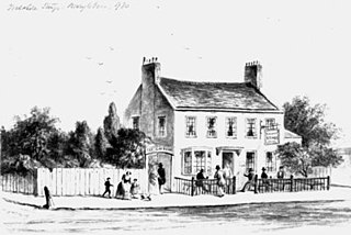
The Yorkshire Stingo was a public house in Marylebone, London in the 18th to mid-20th century. Its name derived from the custom for Yorkshiremen in London to gather at the pub and its adjoining pleasure gardens on the first three days of May each year. In May 1808 it was reported that over 20,000 people gathered there, drinking strong ale, playing football and other 'rustic Yorkshire sports'. The Stingo part of its name comes from a fashionable 18th century slang word for strong or old ale. The term is possibly derived from the sharp, or "stinging" flavour of a well-matured beer.

Great Titchfield Street is a street in the West End of London. It runs north from Oxford Street to Greenwell Street, just short of the busy A501 Marylebone Road and Euston Road. It lies within the informally designated London area of Fitzrovia. In administrative terms it is in the City of Westminster. It lies within their designated East Marylebone Conservation Area in the former Metropolitan Borough of St Marylebone.
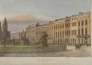
Portman Square is a garden square in Marylebone, central London, surrounded by townhouses. It was specifically for private housing let on long leases having a ground rent by the Portman Estate, which owns the private communal gardens. It marks the western end of Wigmore Street, which connects it to Cavendish Square to the east.
Marylebone is a district in the West End of London, in the City of Westminster. Oxford Street forms its southern boundary.

Homer Street is a quiet one-way street in the Marylebone neighbourhood of the City of Westminster, London. It runs from Old Marylebone Road in the north to Crawford Street in the south. The street is part of the Marylebone Ward of Westminster City Council. Its postcode is W1H.
This is a list of the etymology of street names in the London district of Marylebone. The following utilises the generally accepted boundaries of Marylebone viz. Marylebone Road to the north, Great Portland Street to the east, Marble Arch and Oxford Street to the south and Edgware Road to the west.
Lisson Green is described as a hamlet in the Domesday book in 1086, the edges of the settlement defined by the two current Edgware Road stations facing onto Edgware Road or Watling Street as it was previously known, one of the main Roman thoroughfares in and out of London. Occasionally referred to as Lissom Grove, originally Lisson Grove was part of the medieval manor of Lilestone which stretched as far as Hampstead. Lisson Green as a manor broke away c. 1236 with its own manor house. Paddington Green formed part of the original Lilestone estate.
Grotrian Hall was a London concert venue from 1925 until 1938, located at 15 Seymour Street, Portman Square, London. The site is now covered by an office block backing on to Edwards Mews, behind Selfridges.

Gloucester Place is a street in Marylebone in Central London. Located in the City of Westminster, it runs north from Portman Square across the Marylebone Road eventually merging into Park Road. It is parallel to Baker Street to the east and forms part of the A41 road from nearby Marble Arch.

York Street is a street in Marylebone in Central London. Located in the City of Westminster, it runs west from Baker Street in a straight line until it begins curving when it becomes Harcourt Street towards the Old Marylebone Road. It crosses a number of streets including Seymour Place, Upper Montagu Street and Gloucester Place.

George Street is a street in Marylebone in Central London, England. Located in the City of Westminster, it runs east from Edgware Road until it reaches Marylebone High Street at its junction with Thayer Street. It crosses a number of streets including Seymour Place, Gloucester Place, Manchester Street and Baker Street.

Chiltern Street is a road in the Marylebone area of Central London. Located in the City of Westminster, it runs north to south connecting Marylebone Road and Blandford Street. Baker Street runs parallel a little way to the west. It meets Dorset Street, Crawford Street and Paddington Street along its route. Manchester Square is located beyond the southern end of the street.


