
Markham is a city in York Region, Ontario, Canada. It is approximately 30 km (19 mi) northeast of Downtown Toronto. In the 2021 Census, Markham had a population of 338,503, which ranked it the largest in York Region, fourth largest in the Greater Toronto Area (GTA), and 16th largest in Canada.

Bay Street is a major thoroughfare in Downtown Toronto, Ontario, Canada. It is the centre of Toronto's Financial District and is often used by metonymy to refer to Canada's financial services industry since succeeding Montreal's St. James Street in that role in the 1970s.

Queen Street is a major east–west thoroughfare in Toronto, Ontario, Canada. It extends from Roncesvalles Avenue and King Street in the west to Victoria Park Avenue in the east. Queen Street was the cartographic baseline for the original east–west avenues of Toronto's and York County's grid pattern of major roads. The western section of Queen is a centre for Canadian broadcasting, music, fashion, performance, and the visual arts. Over the past twenty-five years, Queen West has become an international arts centre and a tourist attraction in Toronto.
North York City Centre is a central business district in Toronto, Ontario, Canada in the administrative district of North York. It is located along Yonge Street, between just south of Sheppard Avenue northward to Finch Avenue with its focus around Mel Lastman Square, a civic square, and spreads eastwards and westwards a few blocks, generally as far as Doris Avenue and Beecroft Road. The district is a high-density district of condominium and office towers with ground-floor commercial uses along the wide six lanes of Yonge Street.

Yorkville is a neighbourhood and former village in Toronto, Ontario, Canada. It is roughly bounded by Bloor Street to the south, Davenport Road to the north, Yonge Street to the east and Avenue Road to the west, and it is part of The Annex neighbourhood. Established as a separate community in 1830, it was annexed into Toronto in 1883. Yorkville comprises residential areas, office space, and retail shopping.
Front Street is an east–west road in downtown Toronto, Ontario, Canada. First laid out in 1796, the street is one of the original streets of the Town of York. The street was laid out along the shoreline of Lake Ontario as it existed during that time. It remains an important street, with many important uses located along it, including the St. Lawrence Market, Meridian Hall, Union Station and the Metro Toronto Convention Centre. The eastern section of Front Street, in the West Don Lands, east of Cherry Street, is being rebuilt as a broad tree-lined boulevard, intended to be the pedestrian-friendly commercial spine of the new neighbourhood.
Metro Hall is a 27-storey Postmodern-style office tower at the corner of Wellington and John Street in the downtown core of Toronto, Ontario, Canada. It looks out onto Pecaut Square. Part of the three-tower Metro Centre complex, the building was completed in 1992 to house the Municipality of Metropolitan Toronto (Metro) and its employees. The building is now used by the City of Toronto following municipal consolidation in 1998.

St. Paul's-Avenue Road United Church was a church in Toronto, Ontario. It was founded in the 1870s as St. Paul's Methodist Church. Its home on Avenue Road, just north of Bloor Street in the Yorkville community, was built in 1877. With church union in 1925, it became St. Paul's United Church, and in 1930, it merged with the nearby Avenue Road United Church to form St. Paul's-Avenue Road United Church.

The East York Civic Centre was the municipal office of the former borough of East York, now part of Toronto, Ontario, Canada as the result of municipal amalgamation. The two-storey civic buildings, located on the western side of Coxwell Avenue, were completed in 1990. Prior to 1990 it was the site of the East York Municipal Offices built in 1948, additions added in 1963 and 1975. The Township of East York Municipal Building was located nearby at 443 Sammon Avenue.

The Golden Mile is a commercial district in the Scarborough district of Toronto, Ontario, Canada. Situated along Eglinton Avenue East, east of Victoria Park Avenue, it was one of Canada's first model industrial parks. The original Golden Mile of Industry ran along Eglinton from Pharmacy Avenue east to Birchmount Road.

Old Toronto is the part of Toronto, Ontario, Canada, that corresponds to the boundaries of the City of Toronto prior to 1998. It was incorporated as a city in 1834, after being known as the town of York, and being part of York County. Toronto periodically grew in size by annexing adjacent land and municipalities.

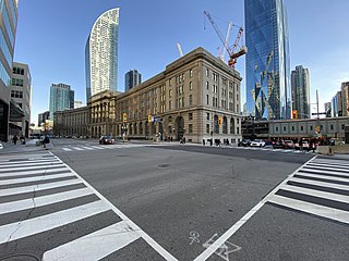
Downtown Toronto is the main city centre of Toronto, Ontario, Canada. Located entirely within the district of Old Toronto, it is approximately 16.6 square kilometres in area, bounded by Bloor Street to the northeast and Dupont Street to the northwest, Lake Ontario to the south, the Don Valley to the east, and Bathurst Street to the west. It is also the home of the municipal government of Toronto and the Government of Ontario.

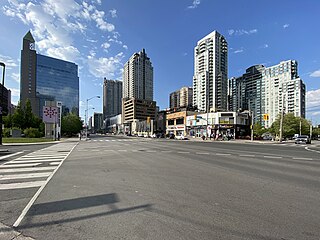
Armadale is a neighbourhood which overlaps the city of Markham, Ontario and the city of Toronto, Ontario, in Canada. The historical community is situated in the south-east of Markham and north-east of the former suburb of Scarborough, now part of Toronto.
The Markham Civic Centre is the city hall of the city of Markham, Ontario. The brick and glass Civic Centre was designed by architect Arthur Erickson with Richard Stevens Architects Limited and was opened on May 25, 1990. The entrances, except for the great hall entrance, are named after communities in Markham. The building is adjacent to an 11.5-hectare park with a large pond reflecting the south façade.

The Discovery District is one of the commercial districts in Downtown Toronto, Ontario, Canada. It has a high concentration of hospitals and research institutions, particularly those related to biotechnology. The district is roughly bounded by Bloor Street on the north, Bay Street on the east, Dundas Street on the south, and Spadina Avenue on the west.

The High Level Pumping Station is a municipal water pumping station in Toronto, Ontario, Canada. It is also home to the central control for the city of Toronto's water distribution system. It is located in a residential neighbourhood near the intersection of Avenue Road and Dupont Street.
St. Andrew's Playground is a small park in downtown Toronto. It is located at the 450 Adelaide Street West, at the northwest corner of Brant St and Adelaide. It has a playground for children and an off-leash area for dogs that is surrounded by a short fence, with an accessible water fountain for pets, children, and adults. A Heritage Toronto plaque in the northwest corner describing the history and significance of the park was installed in 2007.

