Yosemite Cemetery

Last updated

Yosemite Cemetery
Yosemite Cemetery 5.jpg
Yosemite Cemetery
Details
Established1870s
Location
Yosemite Village, Mariposa County, California
CountryUnited States
Size0.25 arce
No. of gravesapprox. 60 graves
Find a Grave Yosemite Cemetery

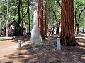
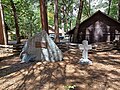
Yosemite Cemetery, also known as Pioneer Cemetery, [1] is a cemetery built in the 1870s and located on the west end of Yosemite Village, in Mariposa County, California. [2] In 2014, the Yosemite Conservancy worked in restoring the cemetery and graves. [3] Many of the graves are from the earliest European-descent pioneers, and a few of the graves were for Native Americans that had lived in the valley. [4]

Contents

Notable burials

See also

Related Research Articles

<span class="mw-page-title-main">Yosemite National Park</span> National park in California, United States

Yosemite National Park is a national park in California. It is bordered on the southeast by Sierra National Forest and on the northwest by Stanislaus National Forest. The park is managed by the National Park Service and covers 759,620 acres in four counties – centered in Tuolumne and Mariposa, extending north and east to Mono and south to Madera. Designated a World Heritage Site in 1984, Yosemite is internationally recognized for its granite cliffs, waterfalls, clear streams, giant sequoia groves, lakes, mountains, meadows, glaciers, and biological diversity. Almost 95 percent of the park is designated wilderness. Yosemite is one of the largest and least fragmented habitat blocks in the Sierra Nevada.

<span class="mw-page-title-main">Yosemite Valley</span> Glacial valley in California, United States

Yosemite Valley is a glacial valley in Yosemite National Park in the western Sierra Nevada mountains of Central California, United States. The valley is about 7.5 mi (12.1 km) long and 3,000–3,500 ft (910–1,070 m) deep, surrounded by high granite summits such as Half Dome and El Capitan, and densely forested with pines. The valley is drained by the Merced River, and a multitude of streams and waterfalls flow into it, including Tenaya, Illilouette, Yosemite and Bridalveil Creeks. Yosemite Falls is the highest waterfall in North America and is a big attraction, especially in the spring, when the water flow is at its peak. The valley is renowned for its natural environment and is regarded as the centerpiece of Yosemite National Park.

<span class="mw-page-title-main">Mariposa County, California</span> County in California, United States

Mariposa County is a county located in the U.S. state of California. As of the 2020 U.S. Census, the population was 17,131. The county seat is Mariposa. It is located in the western foothills of the Sierra Nevada mountains, north of Fresno, east of Merced, and southeast of Stockton.

<span class="mw-page-title-main">Oakhurst, California</span> Census-designated place in California, United States

Oakhurst is a census-designated place (CDP) in Madera County, California, United States, 14 miles (23 km) south of the entrance to Yosemite National Park, in the foothills of the Sierra Nevada. At an elevation of 5,200–2,274 ft (1,585–693 m), Oakhurst is situated at the junction of Highway 41 and Highway 49, marking the southern end of California's Gold Country. It is part of the Madera metropolitan statistical area.

<span class="mw-page-title-main">Mariposa, California</span> Census-designated place in California, United States

Mariposa is an unincorporated community and census-designated place (CDP) in and the county seat of Mariposa County, California, United States. The population was 1,526 at the 2020 census. The community is named after the flocks of monarch butterflies seen overwintering there by early explorers.

<span class="mw-page-title-main">Yosemite Valley, California</span> Census-designated place in California, United States

Yosemite Valley is a census-designated place (CDP) in Mariposa County, California, United States. It consists of the developed area of Yosemite Village and the other areas of the Yosemite Valley in Yosemite National Park. The population was 337 at the 2020 census.

<span class="mw-page-title-main">Wawona, California</span> Census-designated place in California, United States

Wawona is a census-designated place in Mariposa County, California, United States. The population was 111 at the 2020 census.

<span class="mw-page-title-main">History of the Yosemite area</span> History of the Sierra Nevada region of California

Human habitation in the Sierra Nevada region of California reaches back 8,000 to 10,000 years ago. Historically attested Native American populations, such as the Sierra Miwok, Mono and Paiute, belong to the Uto-Aztecan and Utian phyla. In the mid-19th century, a band of Native Americans called the Ahwahnechee lived in Yosemite Valley. The California Gold Rush greatly increased the number of non-indigenous people in the region. Tensions between Native Americans and white settlers escalated into the Mariposa War. As part of this conflict, settler James Savage led the Mariposa Battalion into Yosemite Valley in 1851, in pursuit of Ahwaneechees led by Chief Tenaya. The California state military forces burned the tribe's villages, destroyed their food stores, killed the chief's sons, and forced the tribe out of Yosemite. Accounts from the Mariposa Battalion, especially from Dr. Lafayette Bunnell, popularized Yosemite Valley as a scenic wonder.

<span class="mw-page-title-main">James Mason Hutchings</span>

James Mason Hutchings was an American businessman and one of the principal promoters of what is now Yosemite National Park.

<span class="mw-page-title-main">George Fiske</span> American photographer

George Fiske was an American landscape photographer.

<span class="mw-page-title-main">Mariposa War</span> California conflict

The Mariposa War, also known as the Yosemite Indian War, was a conflict between the United States and the indigenous people of California's Sierra Nevada in the 1850s. The war was fought primarily in Mariposa County and surrounding areas, and was sparked by the discovery of gold in the region. As a result of the military expedition, the Mariposa Battalion became the first non-indigenous group to enter Yosemite Valley and the Nelder Grove.

<span class="mw-page-title-main">Plains and Sierra Miwok</span> Largest group of California Indian Miwok people

The Plains and Sierra Miwok were once the largest group of California Indian Miwok people, Indigenous to California. Their homeland included regions of the Sacramento Valley, San Joaquin Valley, and the Sierra Nevada.

<span class="mw-page-title-main">Little Yosemite Valley</span> Valley in Mariposa County, California

Little Yosemite Valley is a smaller glacial valley upstream in the Merced River drainage from the Yosemite Valley in Yosemite National Park. The Merced River meanders through the 3.5 mi (5.6 km) long flat valley, draining out over Nevada Fall and Vernal Fall before emptying into the main Yosemite Valley. It can be reached by a day hike from the main valley, and is the most popular area in the Yosemite Wilderness. The Valley provides access to nearby destinations such as the back side of Half Dome, Clouds Rest and the High Sierra Camp at Merced Lake.

Charles Leander Weed was an American photographer, who was born in New York state on July 17, 1824, and died in Oakland, California on August 31, 1903. He is perhaps best known for being one of the earliest photographers, if not the first photographer, to enter and photograph what is now Yosemite National Park.

<span class="mw-page-title-main">Grizzly Giant</span> Giant sequoia tree in Yosemite National Park, California, United States

The Grizzly Giant is a giant sequoia in Yosemite National Park's Mariposa Grove. It has been measured many times; in 1990 Wendell Flint calculated its volume at 34,005 cubic feet (962.9 m3), making it the 26th-largest living giant sequoia.

<span class="mw-page-title-main">Yosemite Lodge at the Falls</span> Hotel in Yosemite National Park, California, United States

Yosemite Lodge at the Falls, often referred to informally within the Park as "The Lodge" is located in western Yosemite Village, Yosemite National Park, Mariposa County, California. The lodging accommodation is close to Yosemite Falls.

<span class="mw-page-title-main">Chris Jorgensen</span> American painter (1860-1935)

Christian August Jorgensen was a Norwegian-born American landscape painter. Jorgensen is best known for his paintings of Yosemite Valley and the California Missions.

<span class="mw-page-title-main">Ferguson landslide</span> Landslide in Mariposa County, California

The Ferguson landslide, also commonly called the Ferguson Slide, is an active landslide in the Merced River canyon in Mariposa County, California, United States. In 2006, rocks and debris slid off Ferguson Ridge, blocking California State Route 140, a primary access road to Yosemite National Park. The slide still blocked the original road as of late 2021, although temporary bridges allow one-way traffic around the slide and into the park. The slide is a natural phenomenon, and resulted from the erosion dynamics of the river valley.

<span class="mw-page-title-main">Florence Hutchings (Yosemite)</span> Colorful girl, native of Yosemite National Park

Florence Hutchings was the daughter of James Mason Hutchings and his wife Elvira. She lived a short but colorful life.

References

  1. Burrell, Jackie (January 18, 2017). "Yosemite: 5 surprising spots you don't know about". The Mercury News. Retrieved October 28, 2021.
  2. 1 2 3 4 Medley, Steven P. (October 2, 2012). The Complete Guidebook to Yosemite National Park. Yosemite Conservancy. p. 91. ISBN   978-1-930238-28-2.
  3. 1 2 3 4 5 Burnett, Jim (March 2, 2014). "Yosemite National Park's Restored Cemetery Preserves Ties To The Park's Rich History". Nationalparkstraveler.org. Retrieved October 28, 2021.
  4. Jackson, Richard R. (1953). "Indian Gravesites of the Yosemite Cemetery". Yosemite Nature Notes. p. 119.

Further reading

37°44′56″N119°35′20″W / 37.74877°N 119.58892°W / 37.74877; -119.58892