
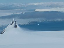
Altsek Nunatak is a 170-metre-high (560 ft) rocky hill projecting from the Murgash Glacier in Dryanovo Heights on Greenwich Island, Antarctica. The peak is named after Khan Altsek, whose Bulgars settled in Italy in the 7th century AD.

Bezmer Point is on the northwest coast of the Varna Peninsula on Livingston Island in the South Shetland Islands, Antarctica. The point is situated 9.6 km east-northeast of Siddins Point and 3 km southwest of Kotis Point and 4.9 km west-southwest of Miziya Peak. The feature was named after the settlement of Bezmer in Southeastern Bulgaria, in association with the Bulgarian ruler Khan Bezmer.

Kabile Island is an Antarctic island extending 700 m (770 yd) in south–north direction and 450 m (490 yd) wide, situated off the north coast of Greenwich Island in the South Shetland Islands, Antarctica. It has a surface area of 19 hectares.
Kotis Point is a point on the northwest coast of Varna Peninsula on Livingston Island in the South Shetland Islands, Antarctica forming the south side of the entrance to Eliseyna Cove. The point is featuring a conspicuous rock at its tip, situated 3 km northeast of Bezmer Point, 6.6 km southwest of Williams Point and 12.6 km east-northeast of Siddins Point. It was named after the Thracian King Kotis I, 384-359 BC.
Murgash Glacier is the 3.4 km long and 3.2 km wide glacier on Greenwich Island in the South Shetland Islands, Antarctica situated southeast of Yakoruda Glacier, south of Teteven Glacier, southwest of Traub Glacier and west-northwest of Bravo Glacier. It is bounded by Lloyd Hill on the northwest, Tile Ridge on the east and Hebrizelm Hill on the southeast, and drains southwards into Kramolin Cove in McFarlane Strait between Yovkov Point and Kaspichan Point.
Pomorie Point is a point on the coast of McFarlane Strait forming the north side of the entrance to Lister Cove, Varna Peninsula, Livingston Island in the South Shetland Islands, Antarctica.

Rila Point is a low, ice-free point on the south coast of Moon Bay, projecting 330 m west-northwestwards from Burgas Peninsula on Livingston Island in the South Shetland Islands, Antarctica, and forming the east side of the entrance to Bruix Cove. The point is named after Rila Mountain, Bulgaria.
Telerig Nunatak is a rocky peak of elevation 170 m projecting from the ice cap of Greenwich Island in the South Shetland Islands, Antarctica in the southwest extremity of Dryanovo Heights.
Wulfila Glacier is located on the southern slopes of Breznik Heights, Greenwich Island in the South Shetland Islands, Antarctica, south-southwest of Solis Glacier and west of Zheravna Glacier. It is bounded by Oborishte Ridge to the northwest, Nevlya Peak to the north, Terter Peak and Razgrad Peak to the northeast, and Ephraim Bluff to the southeast. The glacier extends 3 km in northwest–southeast direction and 2 km in northeast–southwest direction. It drains southwestwards into McFarlane Strait between Ephraim Bluff and the base of Provadiya Hook, feeding the head of Doris Cove.
Kaspichan Point is a point on the southeast side of the entrance to Kramolin Cove on the southwest coast of Greenwich Island, Antarctica. Situated next west of Hebrizelm Hill, 1.4 km northwest of Triangle Point, 2 km south-southwest of Tile Ridge, and 2 km southeast of Yovkov Point. Shape enhanced by recent glacier retreat northwest of the point. Bulgarian topographic survey Tangra 2004/05. Named after the town of Kaspichan in northeastern Bulgaria.
Aprilov Point is a point on the north coast of Greenwich Island, Antarctica situated 6.9 km east of Duff Point, 2.1 km east-southeast of Kabile Island, 2.2 km east-northeast of Crutch Peaks, 1.8 km south of Ongley Island, 5.5 km west of Agüedo Point, and 2.3 km north-northwest of Sevtopolis Peak. Forming the east side of the entrance to Haskovo Cove and the west side of the entrance to Skaptopara Cove.

Beron Point is a point on the southwest coast of Robert Island, Antarctica situated 4.5 km southeast of Negra Point, 1.7 km west of Bajo Nunatak, 1.8 km west-northwest of Zahari Point, and 3.7 km northwest of Edwards Point, as well as 5 km northeast of Ash Point on Greenwich Island. Its shape has been enhanced by a recent glacier retreat north-northwest of the point. It was named after the prominent Bulgarian scientist and educator Dr. Petar Beron (1795–1871).
Zahari Point is an ice-free point on the southwest coast of Robert Island in the South Shetland Islands, Antarctica forming the northwest side of the entrance to Micalvi Cove. Ice-free surface area 21 hectares. The feature is named after the Bulgarian writer and historiographer Zahari Stoyanov (1850–1889).

Ficheto Point is an ice-free point on the northeast coast of Varna Peninsula, Livingston Island, Antarctica forming the southeast side of the entrance to Dragon Cove. Channel Rock is lying in the adjacent northwestern part of McFarlane Strait, 1.3 km (0.81 mi) northeast of Ficheto Point and 920 m (1,010 yd) south-southwest of Meade Islands. The area was visited by 19th century sealers.

Bilyar Point is a rounded ice-free point on Ivanov Beach in western Livingston Island, the South Shetland Islands in Antarctica projecting 350 m into Barclay Bay. Situated 3 km southwest of Rowe Point, northwest of Rotch Dome, 1.7 km northeast of Nedelya Point and 4.5 km east-northeast of Lair Point.
Edinburgh Hill is a narrow point projecting 650 m from the east coast of Varna Peninsula, Livingston Island in the South Shetland Islands, Antarctica into McFarlane Strait and ending up in a conspicuous rocky hill of elevation 180 m. The point forms the northwest side of the entrance to Moon Bay. The area was visited by early 19th century sealers.
Lloyd Hill is an ice-covered hill rising to 335 m in the southwest of Dryanovo Heights, Greenwich Island in the South Shetland Islands, Antarctica. The hill surmounts Teteven Glacier to the north and Murgash Glacier to the southeast.
Brusen Point is the narrow rocky point projecting 200 m in north-northwest direction and forming the north extremity of Greenwich Island in the South Shetland Islands, Antarctica. Nereid Lake is situated 800 m east-southeast of the point, and Proteus Lake lies at its base.
Terimer Point is the low, rounded and ice-free tipped east entrance point of Skaptopara Cove, forming the west extremity of Flamingo Beach on the north coast of Greenwich Island in Antarctica. It is named after the medieval settlement of Terimer in Western Bulgaria.
Bagryana Point is the rounded ice-free tipped point on the southwest coast of Greenwich Island in Antarctica surmounted by Telerig Nunatak. It is named after the Bulgarian poet Elisaveta Bagryana (1893-1991).

