
Tajikistan, officially the Republic of Tajikistan, is a landlocked country in Central Asia. Dushanbe is the capital and most populous city. Tajikistan is bordered by Afghanistan to the south, Uzbekistan to the west, Kyrgyzstan to the north, and China to the east. It is separated from Pakistan by Afghanistan's Wakhan Corridor. It has a population of approximately 10.6 million people.
Tajik, Tajikistan or Tajikistani may refer to. Someone or something related to Tajikistan:

The Tajik Soviet Socialist Republic, also commonly known as Soviet Tajikistan, the Tajik SSR, TaSSR, or simply Tajikistan, was one of the constituent republics of the Soviet Union which existed from 1929 to 1991 in Central Asia.

Administratively, Tajikistan is divided into:

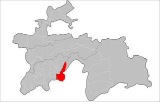
Gorno-Badakhshan, officially the Badakhshan Mountainous Autonomous Region, is an autonomous region in eastern Tajikistan, in the Pamir Mountains. It makes up nearly forty-five percent of the country's land area but only two percent of its population.
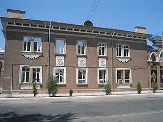
Tursunzoda is a city in western Tajikistan, known for its aluminium smelting plant TadAZ. It is located 60 km west of Dushanbe, near the border with Uzbekistan. It is near several rivers, Shirkent and Karatag immediately to the west and east of the city, and Kofarnihon further east. Its population is estimated at 55,700 for the city proper and 298,800 for the city with the outlying communities (2020). Its population was given as 40,600 in the 1989 census, falling to 39,000 in 2000, and estimated at 37,000 in 2006.

Bobojon Gafurovich Ghafurov or Babadzan Gafurovich Gafurov was a Tajik historian, academician, and the author of several books published in Russian and Tajik, including History of Tajikistan and The Tajiks.
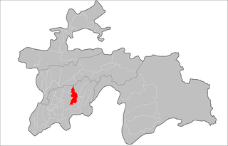
Shamsiddin Shohin District, is a district in Khatlon Region, southeastern Tajikistan. Its capital is the village Shuroobod.
As of 2020, the regions of Tajikistan are subdivided into 47 districts, not including 4 districts belonging to the capital city Dushanbe, and 18 cities of regional subordination. Before ca. 2017, there were 58 districts. The districts are further subdivided into municipal units: either as urban municipalities called either as cities or towns, or as rural municipalities called jamoats, which in turn are further subdivided into villages.
Ayni is a village and jamoat in north-west Tajikistan. It is the capital of Ayni District in Sughd Region, named after the Tajik national poet Sadriddin Ayni. It lies about 177 kilometres (110 mi) from Khujand and 165 kilometres (103 mi) from Dushanbe on the bank of the river Zeravshan. The jamoat has a total population of 14,862 (2015). It consists of 11 villages, including Ayni, Chore, Khushikat, Kumarg, Zasun and Zindakon.
Temurmalik District is a district in the Khatlon Region of Tajikistan, located south of the Vakhsh Range along the middle course of the river Kyzylsu. It had an estimated population of 69,800 as of 2020. Before 1957, it was called Qizil-Mazor District or Kzyl-Mazar District, then renamed Sovetskiy District, and in 2004 given its present name Temurmalik District. The new name honors a medieval military hero, Timur Malik, who in 1220 led the people of Khujand in their struggle against the Mongol occupation.

Nosiri Khusrav District, is a district located in the south-western corner of Khatlon Region of Tajikistan on the Amu Darya. It shares borders with Uzbekistan to the west, Afghanistan to the south and the Shahrtuz District to the north and east. The population of the district is 39,300. Until 2004 it was called Beshkent District ; then renamed in honor of the 11th century Persian-Tajik poet Nosiri Khusrav. The district capital is Bahori, a village at the northernmost tip of the district.
Beshkent is a lowland 70 kilometers in length and 5 kilometers in width—dry without any reliable source of water. beshkent is the warmest valley in Tajikistan, with average temperatures in January and July of 3 °C and 31 °C respectively. The annual average precipitation is 140 millimeters.
Shaydon is a town and a jamoat in north-west Tajikistan. It is the seat of Asht District in Sughd Region. The town proper has a population of 18,200 (2020). The jamoat consists of the town Shaydon and the villages Dahana, Kulikhoja and Mullomir.
Khurramzamin is a village and jamoat in north-western Tajikistan. It is located in Spitamen District in Sughd Region. The jamoat has a total population of 6,246.
Tursun Uljaboev is a jamoat in north-western Tajikistan. It is located in Spitamen District in Sughd Region. The jamoat has a total population of 16,874 (2015). It consists of 4 villages, including Andarsoy.
Kalanak is a village and jamoat in Tajikistan. It is located in Rasht District, one of the Districts of Republican Subordination. The jamoat has a total population of 10,411 (2015). The village is on the northern, right bank of the river Surkhob. On the left bank of the river are the western foothills of the Peter I Range.
Qalailabiob is a village and jamoat in Tajikistan. It is located in Tojikobod District, one of the Districts of Republican Subordination. The jamoat has a total population of 11,102 (2015). The jamoat includes the village Tojikobod, the seat of the district, and 10 other villages.
Ismoil Somoni is a town and jamoat in the Khatlon Region of Tajikistan. It is the capital of Kushoniyon District. The population of the town is 8,500.
Mirzo Tursunzoda is a town and jamoat in Tajikistan. It is located in Rudaki District, one of the Districts of Republican Subordination. The population of the town is 20,500. The town lies south of the capital Dushanbe and north of the district seat Somoniyon. It consists of the villages Istiqlol, Korgar, Mavji, Hojiyon, Kosibon, Turdiev and Rumi.

A series of sporadic border clashes resumed between Kyrgyzstan and Tajikistan on 27 January 2022, following a series of clashes in 2021 between the two countries.
