
Bokn is a municipality in Rogaland county, Norway. It is located in the traditional district of Haugaland. The administrative centre of the municipality is the village of Føresvik, the only urban area in Bokn. Other villages in Bokn include Arsvågen, Trosnavåg, and Loten. The island municipality is mostly located on the three islands of Ognøya, Vestre Bokn, and Austre Bokn. All three main islands are connected to the mainland via a network of bridges.

Suldal is a municipality in the northeast corner of Rogaland county, Norway. It is located in the traditional district of Ryfylke. Since 1965, the administrative centre of Suldal is the village of Sand i Ryfylke. Other villages in Suldal include Hålandsosen, Jelsa, Marvik, Nesflaten, and Suldalsosen.
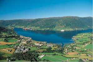
Vindafjord is a municipality in Rogaland county, Norway. It is part of the traditional district of Haugaland. Since 2005, the administrative centre of the municipality has been the village of Ølensjøen, prior to that time it was the village of Sandeid. Other villages in the municipality include Bjoa, Imslandsjøen, Ølensvåg, Skjold, Vats, Vikebygd, and Vikedal. The municipality is centered on the Vindafjorden and Sandeidfjorden in the east and it lies north and east of the Skjoldafjorden in the west.

Sveio is a municipality in Hordaland county, Norway. Sveio is a border district that is sometimes considered to be located in the traditional district of Haugalandet since it is located on the Haugalandet peninsula, but it is also considered to be in the traditional district of Sunnhordland since it is located in southern Hordaland county. The administrative centre of the municipality is the village of Sveio. Other villages in the municipality include Auklandshamn, Førde, Våga, and Valevåg.
Haugaland or Haugalandet is a traditional district situated on the western coast of Norway. Haugaland is one of the 15 traditional districts located within the Vestlandet region.

Aksdal is the administrative centre of Tysvær municipality, Norway. The village is located on the northern shore of the large lake Aksdalsvatnet, at the junction of the European route E134 and European route E39 highways. The village of Førre lies about 3 kilometres (1.9 mi) to the west of Aksdal and the village of Grinde lies about 1.5 kilometres (0.93 mi) to the east. Aksdal Church is located in Aksdal.
Eike is a village in Karmøy municipality in Rogaland county, Norway. The village is located along the western shore of the Førresfjorden, just southeast of the town of Haugesund. The village of Eike, lies just south of the border with the neighboring municipality of Tysvær. Eike is considered part of the larger urban area of Førre, which is centered over the border in Tysvær. The village of Norheim lies about 4 kilometres (2.5 mi) to the west and the village of Vormedal lies about 6 kilometres (3.7 mi) to the southwest.

Aksdalsvatnet is a lake in the municipality of Tysvær in Rogaland county, Norway. The 3.46-square-kilometre (1.34 sq mi) lake lies southeast of the village of Førre and south of the village of Aksdal. The European route E134 highway runs along the northern shore of the lake and the European route E39 highway runs along the eastern shore of the lake.
Stakkastadvatnet is a lake on the border of Rogaland and Hordaland counties in Norway. The 2.92-square-kilometre (1.13 sq mi) lake mostly lies in Rogaland along the municipal borders of Haugesund and Tysvær. A very small portion of the northern part of the lake crosses over into the municipality of Sveio in Hordaland county. The lake lies about 6 kilometres (3.7 mi) northeast of the town of Haugesund. The lake has a small dam on the northwestern edge of the lake. The natural outlet of the lake flows through the dam and into the nearby lake Vigdarvatnet, located to the north.
Susort is a village in Tysvær municipality in Rogaland county, Norway. The village is located along the eastern shore of the Førlandsfjorden, about 5 kilometres (3.1 mi) south of the village of Tysvær. The European route E39 highway runs just outside the village. The word is an old version of the word svarttrost which means "blackbird".

Skjoldafjorden is a fjord in Rogaland county, Norway. The 26-kilometre (16 mi) long fjord is a northern branch of vast Boknafjorden which dominates Rogaland county.

Vats is a former municipality in Rogaland county, Norway. Located in the traditional district of Haugaland, the municipality existed from 1891 until 1965. The 124-square-kilometre (48 sq mi) municipality encompassed the land to the east and west surrounding the Vatsfjorden and the lake Vatsvatnet. Vats is typically divided into two parts Øvre Vats and Nedre Vats.
Nedstrand is a former municipality in Rogaland county, Norway. The 119-square-kilometre (46 sq mi) municipality was located along the Nedstrandfjorden, an inner branch off the main Boknafjorden. The municipality encompassed the majority of the Nedstrand peninsula. Originally it also included the Sjernarøyane islands and the western part of the island of Ombo in the fjord to the south. The administrative centre of the municipality was the village of Nedstrand. Nedstrand Church is located in Hindaråvåg, a small village just west of Nedstrand village. Today, the area is part of the large municipality of Tysvær.
Hindaråvåg or Hinderåvåg is a village in Tysvær municipality in Rogaland county, Norway. The village is located along the Nedstrandsfjorden, on the southern coast of Tysvær. The village of Nedstrand lies about 3 kilometres (1.9 mi) east of Hindaråvåg. The village is the site of Nedstrand Church. The Tveit Upper Secondary School is also located here. This is the only agriculture school in Rogaland county.

Førre or Førresfjorden is a village in Tysvær municipality in Rogaland county, Norway. The village is located at the northern end of the Førresfjorden. A portion of the urban area of this village extends over the municipal border into neighboring Karmøy municipality. The 3.6-square-kilometre (890-acre) village has a population (2014) of 5,362 which gives the village a population density of 1,489 inhabitants per square kilometre (3,860/sq mi).
Skjoldastraumen is a village in Tysvær municipality in Rogaland county, Norway. The village is located along the Skjoldafjorden, about 10 kilometres (6.2 mi) east of the village of Grinde and about 5 kilometres (3.1 mi) northwest of the village of Yrke. The village lies on one of the narrowest parts of the fjord, where there is a set of locks on the fjord to raise and lower boats. The village is the site of the Skjoldastraumen Church.
Tysvær or Tysværvåg is a village in Tysvær municipality in Rogaland county, Norway. The village is located at the end of the small Tysværvågen bay, about 2 kilometres (1.2 mi) off of the European route E39 highway. The nearby village of Susort lies about 8 kilometres (5.0 mi) south of the village of Tysvær, the municipal centre of Aksdal lies about 12 kilometres (7.5 mi) to the north, and the village of Hervik lies about 7 kilometres (4.3 mi) to the east. Tysvær Church is located in the village, serving the southwest portion of the municipality.


