| Zablatje | |
|---|---|
| Village | |
| Country | |
| County | |
| Municipality | Legrad |
| Population (2011) [1] | |
| • Total | 231 |
| Time zone | CET (UTC+1) |
| • Summer (DST) | CEST (UTC+2) |
| Zablatje | |
|---|---|
| Village | |
| Country | |
| County | |
| Municipality | Legrad |
| Population (2011) [1] | |
| • Total | 231 |
| Time zone | CET (UTC+1) |
| • Summer (DST) | CEST (UTC+2) |

Bol is a town on the south of the island of Brač in the Split-Dalmatia County of Croatia, population 1,630 (2011).

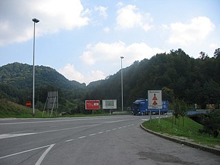
Macelj is the name of a village and a forest in northern Croatia bordering on Slovenia. There is an official border crossing in Macelj, and the end of the A2 highway. The villages are administratively divided into Gornji Macelj (Upper), population 204, and Donji Macelj (Lower), population 566.

Čelarevo is a village located in the Bačka Palanka municipality, in the South Bačka District of Serbia. It is situated in the Autonomous Province of Vojvodina. The village has a Serb ethnic majority and its population numbers 5,423 people.

Ružić is a village and a municipality in Šibenik-Knin County, Croatia. In the 2011 census, it had a total of 1,591 inhabitants. In the 2011 census, 98.99% of the population were Croats.

Ivanska is a village and a municipality in Bjelovar-Bilogora County, Croatia. There are 2,911 inhabitants, of which 92% are Croats. The village of Ivanska itself has a population of 722.

Gornja Rijeka is a municipality in the Koprivnica-Križevci County in Croatia.

Koprivnički Bregi is a municipality in the Koprivnica-Križevci County in Croatia. According to the 2011 census, there are 2,381 inhabitants in the area, with Croats forming an absolute majority.

Csengőd is a village in Bács-Kiskun county, in the Southern Great Plain region of Hungary.

Goričan is a municipality in Međimurje County, Croatia.
Kotoriba is a village and municipality in Međimurje County, in northern Croatia.

Cayuela is a municipality located in the province of Burgos, Castile and León, Spain. According to the 2004 census (INE), the municipality has a population of 130 inhabitants.

Husasău de Tinca is a commune in Bihor County, northwestern Romania with a population of 2,395 people. It is composed of five villages: Fonău (Rózsafalva), Husasău de Tinca, Miersig (Nyárszeg), Oșand (Vasand) and Sititelec (Székelytelek).
Butvydonys is a village in Varėna district municipality, in Alytus County, in southeastern Lithuania. According to the 2001 census, the village has a population of 65 people.

Grab is a village in the municipality of Lučani, Serbia. According to the 2011 census, the village has a population of 242 people.
Veleševec is a village in Croatia.

Zablatje Posavsko is a village in Croatia.
Kozinščak is a settlement in the Dugo Selo town of Zagreb County, Croatia. As of 2011 it had a population of 1,345 people.
Vrbovec Samoborski is a settlement (naselje) in the Samobor administrative territory of Zagreb County, Croatia. As of 2011 it had a population of 271 people.
Banje Selo is a settlement (naselje) in the Sveti Ivan Zelina administrative territory of Zagreb County, Croatia. As of 2011 it had a population of 106 people.
Šalovec is a settlement (naselje) in the Sveti Ivan Zelina administrative territory of Zagreb County, Croatia. As of 2011 it had a population of 169 people.
Coordinates: 46°16′N16°49′E / 46.267°N 16.817°E

A geographic coordinate system is a coordinate system that enables every location on Earth to be specified by a set of numbers, letters or symbols. The coordinates are often chosen such that one of the numbers represents a vertical position and two or three of the numbers represent a horizontal position; alternatively, a geographic position may be expressed in a combined three-dimensional Cartesian vector. A common choice of coordinates is latitude, longitude and elevation. To specify a location on a plane requires a map projection.
| This Koprivnica-Križevci County geography article is a stub. You can help Wikipedia by expanding it. |