Zadawa | |
|---|---|
 Zadawa Location in Nigeria | |
| Coordinates: 11°27′0″N10°22′05″E / 11.45000°N 10.36806°E Coordinates: 11°27′0″N10°22′05″E / 11.45000°N 10.36806°E | |
| Country | |
| State | Bauchi State |
Zadawa is a town in Bauchi State, Nigeria.
Zadawa | |
|---|---|
| Zadawa Location in Nigeria | |
| Coordinates: 11°27′0″N10°22′05″E / 11.45000°N 10.36806°E Coordinates: 11°27′0″N10°22′05″E / 11.45000°N 10.36806°E | |
| Country | |
| State | Bauchi State |
Zadawa is a town in Bauchi State, Nigeria.
Zadawa is located 120 km east of Dutse, 30 km southeast of Azare, 35 km south of Madara, and 40 km east of Faggo. The population of Zadawa is 7,772. [1]
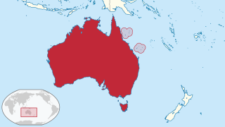
The Coral Sea Islands Territory is an external territory of Australia which comprises a group of small and mostly uninhabited tropical islands and reefs in the Coral Sea, north-east of Queensland, Australia. The only inhabited island is Willis Island. The territory covers 780,000 km2 (301,160 sq mi), most of which is ocean, extending east and south from the outer edge of the Great Barrier Reef and includes Heralds Beacon Island, Osprey Reef, the Willis Group and fifteen other reef/island groups. Cato Island is the highest point in the Territory.

India is situated north of the equator between 8°4' north to 37°6' north latitude and 68°7' east to 97°25' east longitude. It is the seventh-largest country in the world, with a total area of 3,287,263 square kilometres (1,269,219 sq mi). India measures 3,214 km (1,997 mi) from north to south and 2,933 km (1,822 mi) from east to west. It has a land frontier of 15,200 km (9,445 mi) and a coastline of 7,516.6 km (4,671 mi).

Interstate 70 (I-70) is a major east–west Interstate Highway in the United States that runs from I-15 near Cove Fort, Utah, to a park and ride lot just east of I-695 in Baltimore, Maryland, and is the fifth-longest Interstate in the country. I-70 approximately traces the path of U.S. Route 40 east of the Rocky Mountains. West of the Rockies, the route of I-70 was derived from multiple sources. The Interstate runs through or near many major cities, including Denver, Topeka, Kansas City, St. Louis, Indianapolis, Columbus, Pittsburgh, and Baltimore. The sections of the Interstate in Missouri and Kansas have laid claim to be the first Interstate in the United States. The Federal Highway Administration (FHWA) has claimed the section of I-70 through Glenwood Canyon, Colorado, completed in 1992, to be the last piece of the Interstate Highway System, as originally planned, to open to traffic. The construction of I-70 in Colorado and Utah is considered an engineering marvel, as the route passes through the Eisenhower Tunnel, Glenwood Canyon, and the San Rafael Swell. The Eisenhower Tunnel is the highest point along the Interstate Highway System, with an elevation of 11,158 feet (3,401 m).

Rifle is a home rule municipality in and the most populous community of Garfield County, Colorado, United States. The population was 10,437 at the 2020 census. Rifle is a regional center of the cattle ranching industry located along Interstate 70 and the Colorado River just east of the Roan Plateau, which dominates the western skyline of the town. The town was founded in 1882 by Abram Maxfield, and was incorporated in 1905 along Rifle Creek, near its mouth on the Colorado. The community takes its name from the creek.

Laramie is a city in and the county seat of Albany County, Wyoming, United States. The population was estimated 32,711 in 2019, making it the third-largest city in Wyoming after Cheyenne and Casper. Located on the Laramie River in southeastern Wyoming, the city is north west of Cheyenne, at the junction of Interstate 80 and U.S. Route 287.

Sidi Barrani is a town in Egypt, near the Mediterranean Sea, about 95 km (59 mi) east of the Egypt–Libya border, and around 240 km (150 mi) from Tobruk, Libya.

U.S. Route 30 or U.S. Highway 30 (US 30) is an east–west main route in the system of the United States Numbered Highways, with the highway traveling across the northern tier of the country. With a length of 3,073 miles (4,946 km), it is the third longest U.S. highway, after US 20 and US 6. The western end of the highway is at US 101 in Astoria, Oregon; the eastern end is at Virginia Avenue, Absecon Boulevard, and Adriatic Avenue in Atlantic City, New Jersey. The "0" as the last digit in the number indicates that it is a coast-to-coast route and a major east-west route. Despite long stretches of parallel and concurrent Interstate Highways, it has not been decommissioned unlike other long haul routes such as US 66. It is also the only U.S. Highway that has always been coast-to-coast since the beginning of U.S. Route system.

Tokyo Bay is a bay located in the southern Kantō region of Japan, and spans the coasts of Tokyo, Kanagawa Prefecture, and Chiba Prefecture. Tokyo Bay is connected to the Pacific Ocean by the Uraga Channel. The Tokyo Bay region is both the most populous and largest industrialized area in Japan.

The Ordnance Survey National Grid reference system (OSGB) is a system of geographic grid references used in Great Britain, distinct from latitude and longitude.

The Tōhoku Shinkansen is a Japanese high-speed Shinkansen rail line, connecting Tokyo with Aomori in Aomori Prefecture in a route length of 674.9 km (419.4 mi), making it Japan's longest Shinkansen line. It runs through the more sparsely populated Tōhoku region of Japan's main island, Honshu, and was extended as the Hokkaido Shinkansen through the Seikan Tunnel to Shin-Hakodate-Hokuto and is expected to be extended to Sapporo by 2030. It has two Mini-shinkansen branch lines, the Yamagata Shinkansen and Akita Shinkansen. The line is operated by East Japan Railway Company.

Gibbs Island lies 25 km (16 mi) south-west of Elephant Island in the South Shetland Islands of Antarctica. James Weddell, whose chart of the islands appeared in 1825, was apparently the first to use the current name of this island, discovered in 1821 by Russians who then named it Rozhnov Island.
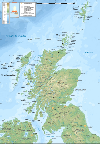
The geography of Scotland is varied, from rural lowlands to unspoilt uplands, and from large cities to sparsely inhabited islands. Located in Northern Europe, Scotland comprises the northern third of the island of Great Britain as well as 790 surrounding islands encompassing the major archipelagos of the Shetland Islands, Orkney Islands and the Inner and Outer Hebrides.

The Indian State of Karnataka is located between 11°30' North and 18°30' North latitudes and between 74° East and 78°30' East longitude.It is situated on a tableland where the Western Ghats and Eastern Ghats converge into the complex, in the western part of the Deccan Peninsular region of India. The State is bounded by Maharashtra and Goa States in the north and northwest; by the Lakshadweep Sea in the west; by Kerala in the south-west and Tamil Nadu in the south and south-east, Andhra Pradesh in the south-east and east and Telangana in the north-east. Karnataka extends to about 850 km (530 mi) from north to south and about 450 km (280 mi) from east to west.

Azare is a town in Bauchi State, Nigeria. It was founded by Mallam Zaki who was put into office by Shehu Usman Danfodio during early 1814. Azare is the headquarter of Katagum division in Bauchi State, Azare town is bordered to the east by Damban LGA and Potiskum Yobe State and to the south by Misau Local Government, in the west by Jama'are Local Government, and to the north by Itas/Gadau Local Government Area of Bauchi State.

The pallid scops owl is a small scops owl ranging from the Middle East to west and central Asia, sometimes called the striated scops owl.
Highway 31 is a highway in the Canadian province of Saskatchewan. It runs from Highway 14 in Macklin to Highway 4 north of Rosetown. Highway 31 is about 185 km (115 mi) long.

Interstate 35 (I-35) in Texas is a major north–south Interstate Highway running from Laredo near the Mexican border to the Red River north of Gainesville where it crosses into Oklahoma. Along its route, it passes through the cities of San Antonio, Austin, and Waco before it splits into two auxiliary routes just north of Hillsboro. I-35E heads northeast where it passes through Dallas. I-35W turns northwest to run through Fort Worth. The two branches meet up in Denton to again form I-35, where it continues to the Oklahoma border. The exit numbers for I-35E maintain the sequence of exit numbers from the southern segment of I-35, and the northern segment of I-35 follows on from the sequence of exit numbers from I-35E. I-35W maintains its own sequence of exit numbers.
Sénac is a small village located in the south of France, in the department of Hautes-Pyrénées of the region Occitanie. The INSEE code for Sénac is 65418, and the Sénac zip code is 65140.
| | This Bauchi State, Nigeria location article is a stub. You can help Wikipedia by expanding it. |