
The Yentna River is a river in South Central Alaska, formed by its East Fork and West Fork at 62°16′50″N151°46′26″W, flows South-East to Susitna River, 30 miles (48 km) North-West of Anchorage, Alaska; Cook Inlet Low.

Kelmė District Municipality is one of 60 municipalities in Lithuania, located in western part of Lithuania.

Brushford is a village and civil parish in the Mid Devon district of Devon in England. According to the 2001 census it had a population of 59. The village is situated on the River Taw, and is about 12 miles north-east of Okehampton.

Štefanovce is a village and municipality in Vranov nad Topľou District in the Prešov Region of eastern Slovakia.
Zaamar is a sum of Töv Province in Mongolia.

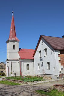
Kondratowice is a village in Strzelin County, Lower Silesian Voivodeship, in south-western Poland. It is the seat of the administrative district (gmina) called Gmina Kondratowice.

Tân Châu is a town of An Giang Province in the Mekong Delta region of Vietnam. As of 2009 the town had a population of 184,129. The town covers an area of 175.68 km².
Chrzanów is a village in Janów Lubelski County, Lublin Voivodeship, in eastern Poland. It is the seat of the gmina called Gmina Chrzanów. It lies approximately 15 kilometres (9 mi) north-east of Janów Lubelski and 53 km (33 mi) south of the regional capital Lublin.
Fortepian is a village in the administrative district of Gmina Biecz, within Gorlice County, Lesser Poland Voivodeship, in southern Poland. It lies approximately 9 kilometres (6 mi) north-west of Biecz, 14 km (9 mi) north of Gorlice, and 94 km (58 mi) east of the regional capital Kraków.
Wólka Czarnostocka is a village in the administrative district of Gmina Radecznica, within Zamość County, Lublin Voivodeship, in eastern Poland.
Stary Garbów is a village in the administrative district of Gmina Dwikozy, within Sandomierz County, Świętokrzyskie Voivodeship, in south-central Poland. It lies approximately 5 kilometres (3 mi) north of Dwikozy, 11 km (7 mi) north of Sandomierz, and 83 km (52 mi) east of the regional capital Kielce.
Ropocice is a village in the administrative district of Gmina Secemin, within Włoszczowa County, Świętokrzyskie Voivodeship, in south-central Poland. It lies approximately 4 kilometres (2 mi) east of Secemin, 11 km (7 mi) south-west of Włoszczowa, and 53 km (33 mi) west of the regional capital Kielce.
Dzbańce is a village in the administrative district of Gmina Branice, within Głubczyce County, Opole Voivodeship, in south-western Poland, close to the Czech border. It lies approximately 7 kilometres (4 mi) north-east of Branice, 13 km (8 mi) south of Głubczyce, and 65 km (40 mi) south of the regional capital Opole.

Hóa Tiến is a commune (xã) and village in Minh Hóa District, Quảng Bình Province, in Vietnam.

The Tunnel de la Croix-Rousse is a pair of two tunnels located in the 1st and 4th arrondissements of Lyon, a road tunnel opened to traffic on 19 April 1952 and a sustainable transport tunnel opened in 2013.
Enivere is a village in Lääne-Nigula Parish, Lääne County, in western Estonia.
Leina is a village in Saaremaa Parish, Saare County in western Estonia.

This is a list of the extreme points of Sri Lanka.

Dikilitaş is the name of a rock monument and a neighbourhood of Mersin, Turkey named after the monument.
Smolani is a former village in Municipality of Prilep, Republic of Macedonia.


