Laskowa is a village in the administrative district of Gmina Żmigród, within Trzebnica County, Lower Silesian Voivodeship, in south-western Poland. Prior to 1945 it was in Germany. It lies approximately 12 kilometres (7 mi) north-west of Żmigród, 34 km (21 mi) north-west of Trzebnica, and 51 km (32 mi) north of the regional capital Wrocław.
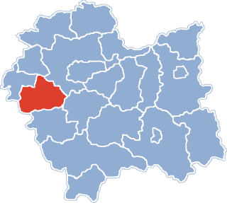
Jaroszowice is a village in the administrative district of Gmina Wadowice, within Wadowice County, Lesser Poland Voivodeship, in southern Poland. It lies approximately 4 kilometres (2 mi) south-east of Wadowice and 37 km (23 mi) south-west of the regional capital Kraków.
Kaczyna is a village in the administrative district of Gmina Wadowice, within Wadowice County, Lesser Poland Voivodeship, in southern Poland. It lies approximately 8 kilometres (5 mi) south-west of Wadowice and 45 km (28 mi) south-west of the regional capital Kraków.
Wysoka is a village in the administrative district of Gmina Wadowice, within Wadowice County, Lesser Poland Voivodeship, in southern Poland. It lies approximately 9 kilometres (6 mi) north-east of Wadowice and 30 km (19 mi) south-west of the regional capital Kraków.
Sosnowice is a village in the administrative district of Gmina Brzeźnica, within Wadowice County, Lesser Poland Voivodeship, in southern Poland. It lies approximately 7 kilometres (4 mi) east of Brzeźnica, 18 km (11 mi) north-east of Wadowice, and 21 km (13 mi) south-west of the regional capital Kraków.
Leńcze is a village in the administrative district of Gmina Kalwaria Zebrzydowska, within Wadowice County, Lesser Poland Voivodeship, in southern Poland. It lies approximately 5 kilometres (3 mi) north-east of Kalwaria Zebrzydowska, 16 km (10 mi) east of Wadowice, and 24 km (15 mi) south-west of the regional capital Kraków.
Jamnik is a village in the administrative district of Gmina Mucharz, within Wadowice County, Lesser Poland Voivodeship, in southern Poland. It lies approximately 8 kilometres (5 mi) south of Wadowice and 41 km (25 mi) south-west of the regional capital Kraków.

Jaszczurowa is a village in the administrative district of Gmina Mucharz, within Wadowice County, Lesser Poland Voivodeship, in southern Poland. It lies approximately 9 kilometres (6 mi) south-east of Wadowice and 39 km (24 mi) south-west of the regional capital Kraków.
Koziniec is a village in the administrative district of Gmina Mucharz, within Wadowice County, Lesser Poland Voivodeship, in southern Poland. It lies approximately 5 kilometres (3 mi) north-west of Mucharz, 6 km (4 mi) south of Wadowice, and 41 km (25 mi) south-west of the regional capital Kraków.

Mucharz is a village in Wadowice County, Lesser Poland Voivodeship, in southern Poland. It is the seat of the gmina called Gmina Mucharz. It lies approximately 9 kilometres (6 mi) south-east of Wadowice and 39 km (24 mi) south-west of the regional capital Kraków.
Skawce is a village in the administrative district of Gmina Mucharz, within Wadowice County, Lesser Poland Voivodeship, in southern Poland. It lies approximately 12 kilometres (7 mi) south-east of Wadowice and 39 km (24 mi) south-west of the regional capital Kraków.
Stronie is a village in the administrative district of Gmina Stryszów, within Wadowice County, Lesser Poland Voivodeship, in southern Poland. It lies approximately 4 kilometres (2 mi) east of Stryszów, 14 km (9 mi) south-east of Wadowice, and 32 km (20 mi) south-west of the regional capital Kraków.
Lgota is a village in the administrative district of Gmina Tomice, within Wadowice County, Lesser Poland Voivodeship, in southern Poland. It lies approximately 7 kilometres (4 mi) north-east of Tomice, 8 km (5 mi) north-east of Wadowice, and 31 km (19 mi) south-west of the regional capital Kraków.
Witanowice is a village in the administrative district of Gmina Tomice, within Wadowice County, Lesser Poland Voivodeship, in southern Poland. It lies approximately 6 kilometres (4 mi) north-east of Tomice, 7 km (4 mi) north-east of Wadowice, and 32 km (20 mi) south-west of the regional capital Kraków.
Gołoty is a village in the administrative district of Gmina Ciechanów, within Ciechanów County, Masovian Voivodeship, in east-central Poland. It lies approximately 6 kilometres (4 mi) south-west of Ciechanów and 75 km (47 mi) north-west of Warsaw.
Izdebno is a village in the administrative district of Gmina Łaskarzew, within Garwolin County, Masovian Voivodeship, in east-central Poland. It lies approximately 6 kilometres (4 mi) north of Łaskarzew, 9 km (6 mi) south-west of Garwolin, and 58 km (36 mi) south-east of Warsaw.
Chomętowo is a village in the administrative district of Gmina Radzanowo, within Płock County, Masovian Voivodeship, in east-central Poland. It lies approximately 5 kilometres (3 mi) west of Radzanowo, 10 km (6 mi) east of Płock, and 89 km (55 mi) north-west of Warsaw.

Topór is a village in the administrative district of Gmina Stoczek, within Węgrów County, Masovian Voivodeship, in east-central Poland. It lies approximately 6 kilometres (4 mi) west of Stoczek, 23 km (14 mi) north-west of Węgrów, and 69 km (43 mi) north-east of Warsaw.
Sławno is a village in the administrative district of Gmina Lubasz, within Czarnków-Trzcianka County, Greater Poland Voivodeship, in west-central Poland. It lies approximately 5 kilometres (3 mi) south-east of Lubasz, 8 km (5 mi) south of Czarnków, and 54 km (34 mi) north-west of the regional capital Poznań.