
Kuźnica Goszczańska is a village in the administrative district of Gmina Twardogóra, within Oleśnica County, Lower Silesian Voivodeship, in south-western Poland. Prior to 1945 it was in Germany.

Sverdlov is a village in the Lori Province of Armenia.
Zagrodniki is a village in the administrative district of Gmina Rusiec, within Bełchatów County, Łódź Voivodeship, in central Poland. It lies approximately 5 kilometres (3 mi) east of Rusiec, 23 km (14 mi) west of Bełchatów, and 58 km (36 mi) south-west of the regional capital Łódź.
Bielawy is a village in the administrative district of Gmina Strzelce, within Kutno County, Łódź Voivodeship, in central Poland. It lies approximately 12 kilometres (7 mi) north of Kutno and 62 km (39 mi) north of the regional capital Łódź.

Mirik is a village in the Lachin Rayon of Azerbaijan, de facto part of the Republic of Artsakh.
Kita is a small village in the administrative district of Gmina Złoczew, within Sieradz County, Łódź Voivodeship, in central Poland.
Uników is a village in the administrative district of Gmina Złoczew, within Sieradz County, Łódź Voivodeship, in central Poland. It lies approximately 5 kilometres (3 mi) west of Złoczew, 27 km (17 mi) south-west of Sieradz, and 77 km (48 mi) south-west of the regional capital Łódź.
Kocia Wólka is a village in the administrative district of Gmina Tarnawatka, within Tomaszów Lubelski County, Lublin Voivodeship, in eastern Poland.
Maciejów is a village in the administrative district of Gmina Słaboszów, within Miechów County, Lesser Poland Voivodeship, in southern Poland. It lies approximately 6 kilometres (4 mi) west of Słaboszów, 14 km (9 mi) east of Miechów, and 43 km (27 mi) north-east of the regional capital Kraków.
Polanka Horyniecka is a village in the administrative district of Gmina Horyniec-Zdrój, within Lubaczów County, Subcarpathian Voivodeship, in south-eastern Poland, close to the border with Ukraine. It lies approximately 18 kilometres (11 mi) north-east of Lubaczów and 98 km (61 mi) east of the regional capital Rzeszów.
Szyszczyce is a village in the administrative district of Gmina Działoszyce, within Pińczów County, Świętokrzyskie Voivodeship, in south-central Poland. It lies approximately 5 kilometres (3 mi) north-east of Działoszyce, 18 km (11 mi) south-west of Pińczów, and 56 km (35 mi) south of the regional capital Kielce.
Piła is a settlement in the administrative district of Gmina Wronki, within Szamotuły County, Greater Poland Voivodeship, in west-central Poland.
Brzękowice-Wał is a village in the administrative district of Gmina Psary, within Będzin County, Silesian Voivodeship, in southern Poland. It lies approximately 3 kilometres (2 mi) north of Psary, 8 km (5 mi) north of Będzin, and 19 km (12 mi) north-east of the regional capital Katowice.
Kuźnica Masłońska is a village in the administrative district of Gmina Łazy, within Zawiercie County, Silesian Voivodeship, in southern Poland. It lies approximately 3 kilometres (2 mi) north of Łazy, 5 km (3 mi) south of Zawiercie, and 37 km (23 mi) north-east of the regional capital Katowice.
Krzewino is a settlement in the administrative district of Gmina Kartuzy, within Kartuzy County, Pomeranian Voivodeship, in northern Poland.
Karolewo is a village in the administrative district of Gmina Zblewo, within Starogard County, Pomeranian Voivodeship, in northern Poland. It lies approximately 5 kilometres (3 mi) east of Zblewo, 9 km (6 mi) west of Starogard Gdański, and 50 km (31 mi) south of the regional capital Gdańsk.
Poganowo is a former village in the administrative district of Gmina Kętrzyn, within Kętrzyn County, Warmian-Masurian Voivodeship, in northern Poland. It lies approximately 7 kilometres (4 mi) south of Kętrzyn and 65 km (40 mi) north-east of the regional capital Olsztyn.

The Swedish National Museum of Science and Technology is a Swedish museum in Stockholm. It is Sweden’s largest museum of technology, and has a national charter to be responsible for preserving the Swedish cultural heritage related to technological and industrial history. Its galleries comprise around 10,000 square meters, and the museum attracts annually about 350, 000 visitors. The collections consist of more than 50,000 objects and artifacts, 600 shelf metres of archival records and documents, 200,000 drawings, 620,000 images and just over 50,000 books. The National Museum of Science and Technology also documents technologies, processes, stories and memoirs in order to preserve them for generations to come.
Mijeon Station is a railway station on the Gyeongbu Line.
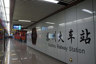
Suzhou railway station is a station on Line 2 of Suzhou Rail Transit. The station is located at the Suzhou railway station in Gusu District of Suzhou. It started service on December 28, 2013 with the opening of Line 2.


