
Maten al-Sahel, is a village in Tartus Governorate, northwestern Syria
Tayru is a village in northwestern Syria, administratively part of the Tartus Governorate, located northeast of Tartus and just east of the Mediterranean town of Baniyas. Nearby localities include Bustan al-Hamam and al-Annazeh to the east, al-Qadmus and Kaff al-Jaa to the southeast, al-Qamsiyah, al-Baydah and Maten al-Sahel to the south. According to the Syria Central Bureau of Statistics, Tayru had a population of 838 in the 2004 census. Its inhabitants are predominantly Alawites.
Al-Qadmus is a town in northwestern Syria, administratively part of the Tartus Governorate, located northeast of Tartus and 14 kilometres southeast of Baniyas. Nearby localities include Kaff al-Jaa and Masyaf to the east, Wadi al-'Uyun and al-Shaykh Badr to the south, Hammam Wasel, al-Qamsiyah and Maten al-Sahel to the southwest, Taanita to the west, al-Annazeh to the northwest and Deir Mama to the northeast. It is situated just east of the Mediterranean coast and its ruined castle stands on a plateau roughly 850 metres above sea level and just above the town.
Khirbet al-Sawda is a village in western Syria, administratively part of the Homs Governorate, northwest of Homs. Nearby towns include Khirbet al-Tin Mahmud to the southwest, Qazhal to the south and Dar al-Kabera to the northeast. According to the Central Bureau of Statistics (CBS), Khirbet al-Sawda had a population of 507 in the 2004 census.
Khirbet al-Tin Mahmoud is a village in western Syria, administratively part of the Homs Governorate, east of Homs. Nearby localities include Khirbet al-Sawda to the northeast, al-Ghor al-Gharbiya to the north, Shin to the west and Khirbet Tin Nur to the south. According to the Central Bureau of Statistics (CBS), Khirbet al-Tin Mahmoud had a population of 866 in the 2004 census.
Qazhal is a village in western Syria, administratively part of the Homs Governorate, just west of Homs. Nearby localities include the al-Waer suburb of Homs to the east, Khirbet al-Sawda to the north, Khirbet Tin Mahmoud to the northwest and Khirbet Tin Nur to the southwest. According to the Central Bureau of Statistics (CBS), Qazhal had a population of 2,271 in the 2004 census. Its inhabitants are predominantly Turkmens.
Al-Qastal is a village in southern Syria, administratively part of the Rif Dimashq Governorate, located on the northeast of Damascus, on the ancient caravan route to Homs and Aleppo, in the Qalamoun Mountains. Nearby localities include Yabroud, an-Nabek, al-Sahel and Deir Atiyah to the north, ar-Ruhaybah, Jayroud, al-Dumayr and al-Qutayfah to the south, and Ma'loula, Assal al-Ward and Hosh Arab to the southwest. According to the Syria Central Bureau of Statistics, al-Qastal had a population of 3,486 in the 2004 census. Its inhabitants are predominantly Sunni Muslims.
Liftaya is a village in central Syria, administratively part of the Homs Governorate, located southwest of Homs near Lake Homs. Nearby localities include Wujuh al-Hajar to the southeast, Khirbet Ghazi, Khirbet al-Sawda and Khirbet Tin Nur to the northeast. According to the Central Bureau of Statistics (CBS), Liftaya had a population of 2,047 in the 2004 census.
Al-Qamsiyah is a town in northwestern Syria, administratively part of the Tartus Governorate, located north of Tartus. Nearby localities include al-Annazeh, Maten al-Sahel and Husayn al-Baher to the southwest and Khawabi, Khirbet al-Faras and al-Shaykh Badr to the southeast. According to the Syria Central Bureau of Statistics (CBS), al-Qamsiyah had a population of 2,244 in the 2004 census. Its inhabitants are predominantly Alawites.
Brummanet al-Mashayekh is a town in northwestern Syria, administratively part of the Tartus Governorate, located northeast of Tartus. Nearby localities include al-Annazeh, Maten al-Sahel and al-Shaykh Badr to the west, Kaff al-Jaa and al-Qadmus to the north and Wadi al-Oyun and Ayn Halaqim to the southeast. According to the Syria Central Bureau of Statistics (CBS), Brummanet al-Mashayekh had a population of 3,666 in the 2004 census.
Al-Bayda is a village in northwestern Syria, administratively part of the Tartus Governorate, located north of Tartus. Nearby localities include Baniyas to the north, Kharibah to the east and Maten al-Sahel to the south. It is situated just east of the Mediterranean coast. According to the Syria Central Bureau of Statistics, al-Bayda had a population of 5,783 in the 2004 census, making it the second largest locality in the Baniyas nahiyah ("subdistrict") after the city of Baniyas. The Arab-majority of al-Bayda are predominantly Sunni Muslims with a Christian minority, and together with Baniyas, Basatin al-Assad and Marqab, the villages form a large Arab population amid a Alawite-inhabited area.
Al-Sawda is a town in northwestern Syria, administratively part of the Tartus Governorate, located 15 kilometers northeast of Tartus. Nearby localities include Annazah to the northeast, Maten al-Sahel to the northwest, Husayn al-Baher to the west, Dweir al-Shaykh Saad to the southwest, Awaru to the south, Khirbet al-Faras to the southeast and Khawabi to the east. According to the Syria Central Bureau of Statistics, al-Sawda had a population of 4,064 in the 2004 census. It is the administrative center of the al-Sawda nahiyah ("sub-district") which contained 27 localities with a collective population of 32,925 in 2004. The inhabitants are predominantly Christians, of the Greek Orthodox Church.
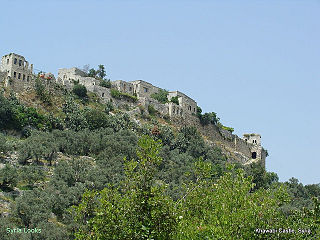
Khawabi, also spelled Qal'at al-Khawabi is a village and medieval citadel in northwestern Syria, administratively part of the Tartus Governorate, located 20 kilometers northeast of Tartus and 12 kilometers east of al-Sawda. According to the Syria Central Bureau of Statistics, Khawabi had a population of 1,039 in the 2004 census. Its inhabitants are predominantly Sunni Muslims. The village formerly had a significant Ismaili population until the early 20th century, and during the medieval period, its citadel served as a center of the Ismaili community when they were known as the Assassins. The citadel itself has been inhabited since at least the 12th century.
Husayn al-Baher is a village in northwestern Syria, administratively part of the Tartus Governorate, located north of Tartus. Nearby localities include Maten al-Sahel to the north, Annazah to the northeast, al-Sawda to the east, Awaru and Khirbet al-Faras to the southeast and Dweir al-Shaykh Saad to the south. According to the Syria Central Bureau of Statistics, Husayn al-Baher had a population of 4,350 in the 2004 census, making it the largest locality of the al-Sawda nahiyah ("sub-district"). The inhabitants of the village are predominantly Alawites, along with a Christian minority.
Bimalkah is a village and suburb in northwestern Syria, administratively part of the Tartus Governorate, located 10 kilometers northeast of Tartus. Nearby localities include Dweir al-Shaykh Saad to the west, al-Shaykh Saad and al-Khreibat to the southwest, Tayshur to the southeast, al-Baqaa and Hamin to the east, Khawabi and Khirbet al-Faras to the northeast, Awaru and al-Sawda to the north and Husayn al-Baher to the northwest.
Al-Khreibat is a village and suburb in northwestern Syria, administratively part of the Tartus Governorate, located southeast of Tartus. Nearby localities include Beit Kammun to the south, Dibbash to the southeast, Tayshur to the east, and al-Shaykh Saad to the north.
Awaru is a hamlet in northwestern Syria, administratively part of the al-Sawda municipality of the Tartus Governorate, located northeast of Tartus. Nearby localities include al-Sawda to the north, Khawabi to the east, Khirbet al-Faras to the southeast, Bimalkah to the south, Dweir al-Shaykh Saad to the southwest and Husayn al-Baher to the northwest.
Khirbet al-Sawda is a Syrian village in the Beit Jinn sub-district of Qatana District, in the Rif Dimashq Governorate. According to the Syria Central Bureau of Statistics, Khirbet al-Sawda had a population of 124 at the 2004 census. Its inhabitants are predominantly Druze.
Duwayr Taha is a village in northwestern Syria, administratively part of the Tartus Governorate. It is situated near the Mediterranean coast. According to the Syria Central Bureau of Statistics (CBS), Duwayr Taha had a population of 1,714 in the 2004 census. Its inhabitants are predominantly Greek Orthodox Christians.
Zimrin is a village in southern Syria, administratively part of the al-Sanamayn District of the Daraa Governorate. Nearby localities include Qayta and al-Sanamayn to the east, Samlin and Inkhil to the southeast, Jasim to the south, Nimer to the southwest, al-Harra to the west, Aqraba to the northwest and Kafr Shams to the northeast. In the 2004 census by the Central Bureau of Statistics (CBS), Zimrin had a population of 2,048.

