Aqir Zayti

Last updated
Aqir Zayti
عقر زيتي
Aqir Zeit
Village
Syria adm location map.svg
Red pog.svg
Aqir Zayti
Location in Syria
Coordinates: 34°57′43″N36°0′23″E / 34.96194°N 36.00639°E / 34.96194; 36.00639 Coordinates: 34°57′43″N36°0′23″E / 34.96194°N 36.00639°E / 34.96194; 36.00639
CountryFlag of Syria.svg  Syria
Governorate Tartus
District Tartus
Subdistrict al-Sawda
Population (2004)
  Total 783
Time zone EET (UTC+2)
  Summer (DST) EEST (UTC+3)
City Qrya Pcode C3409

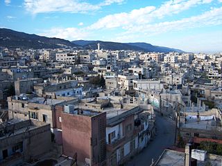
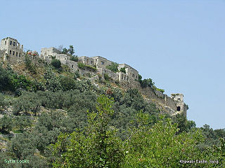
Aqir Zayti (Arabic : عقر زيتي, also spelled Aqir Zayt or Aqir Zeit) is a village in northwestern Syria, administratively part of the Tartus Governorate, located in the Syrian Coastal Mountain Range, east of Tartus. The village of Khirbet al-Faras is located immediately south. According to the Syria Central Bureau of Statistics (CBS), Aqir Zayti had a population of 783 in the 2004 census. [1] Its inhabitants are predominantly Ismailis, who moved there after being forced out from the nearby fortress village of Khawabi in the early 20th century. [2]

Syria Country in Western Asia

Syria, officially the Syrian Arab Republic, is a country in Western Asia, bordering Lebanon to the southwest, the Mediterranean Sea to the west, Turkey to the north, Iraq to the east, Jordan to the south, and Israel to the southwest. A country of fertile plains, high mountains, and deserts, Syria is home to diverse ethnic and religious groups, including Syrian Arabs, Greeks, Armenians, Assyrians, Kurds, Circassians, Mandeans and Turks. Religious groups include Sunnis, Christians, Alawites, Druze, Isma'ilis, Mandeans, Shiites, Salafis, Yazidis, and Jews. Sunni make up the largest religious group in Syria.

Tartus Governorate Governorate in Syria

Tartus Governorate is one of the fourteen governorates (provinces) of Syria. It is situated in western Syria, bordering Lebanon to the south, the Mediterranean Sea to the west, Latakia Governorate to the north, and Homs and Hama Governorates to the east. It is one of the few governorates in Syria that has an Alawite majority. Sources list the area as 1,890 km² or 1,892 km². The governorate has a population of 785,000. The capital is Tartus.

Syrian Coastal Mountain Range mountain

The Coastal Mountain Range is a mountain range in northwestern Syria running north-south, parallel to the coastal plain. The mountains have an average width of 32 kilometres (20 mi), and their average peak elevation is just over 1,200 metres (3,900 ft) with the highest peak, Nabi Yunis, reaching 1,562 metres (5,125 ft), east of Latakia. In the north the average height declines to 900 metres (3,000 ft), and to 600 metres (2,000 ft) in the south.

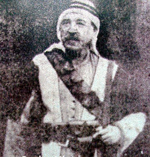
Aqir Zayti contains the al-Hajj Khidr Tomb, an important Ismaili shrine. According to local Ismaili legend, which is partly rooted in historical facts, al-Hajj Khidr was an Ismaili religious sheikh from al-Qadmus who became popular in that area and was consequently forced by that town's Ismaili emirs. Al-Hajj Khidr later represented the Ismaili community of Khawabi, where he and his supporters took refuge, on a delegation to meet the chief imam of the Ismailis in India. The imam in India assigned al-Hajj Khidr to become the chief missionary of Syria, replacing the aging Muhammad al-Suwaydani. Upon returning to Syria, al-Hajj Khidr's authority was rejected by the Ismaili emirs of al-Qadmus, Masyaf and Wadi al-Uyun. The two sides later clashes and al-Hajj Khidr and many of his partisans were killed. [3] Due to reforms by Aga Khan III which forbade shrine worship, al-Hajj Khidr's shrine was dismantled in the early 20th century. [4]

Al-Qadmus Town in Tartus, Syria

Al-Qadmus is a town in northwestern Syria, administratively part of the Tartus Governorate, located northeast of Tartus and 14 kilometres southeast of Baniyas. Nearby localities include Kaff al-Jaa and Masyaf to the east, Wadi al-'Uyun and al-Shaykh Badr to the south, Hammam Wasel, al-Qamsiyah and Maten al-Sahel to the southwest, Taanita to the west, al-Annazeh to the northwest and Deir Mama to the northeast. It is situated just east of the Mediterranean coast and its ruined castle stands on a plateau roughly 850 metres above sea level and just above the town.

Imam Islamic leadership position

Imam is an Islamic leadership position.

India Country in South Asia

India, also known as the Republic of India, is a country in South Asia. It is the seventh largest country by area and with more than 1.3 billion people, it is the second most populous country as well as the most populous democracy in the world. Bounded by the Indian Ocean on the south, the Arabian Sea on the southwest, and the Bay of Bengal on the southeast, it shares land borders with Pakistan to the west; China, Nepal, and Bhutan to the northeast; and Bangladesh and Myanmar to the east. In the Indian Ocean, India is in the vicinity of Sri Lanka and the Maldives, while its Andaman and Nicobar Islands share a maritime border with Thailand and Indonesia.

Related Research Articles

Aga Khan Imām of the Nizari Ismāʿīli Shias

Aga Khan is a title held by the Imām of the Nizari Ismāʿīli Shias. Since 1957, the holder of the title has been the 49th Imām, Prince Shah Karim al-Husseini, Aga Khan IV.

Masyaf Place in Hama, Syria

Masyaf is a city in northwestern Syria. It is the center of the Masyaf District in the Hama Governorate. As of 2004, Masyaf had a religiously diverse population of 22,000 Ismailis, Alawites and Christians. The city is well known for its large medieval castle, particularly its role as the headquarters of the Nizari Ismailis and their elite Assassins unit.

Salamiyah Place in Hama Governorate, Syria

Salamiyah (Arabic: سلمية‎ Salamīya) is a city and district in western Syria, in the Hama Governorate. It is located 33 kilometres southeast of Hama, 45 kilometres northeast of Homs. The city is nicknamed the "mother of Cairo" because it was the birthplace of the second Fatimid Caliph Muhammad al-Qaim Bi-Amrillah, whose dynasty would eventually establish the city of Cairo, and the early headquarters of his father Abdullah al-Mahdi Billah who founded the Fatimid Caliphate. The city is an important center of the Shi'ite Nizari Ismaili and Taiyabi Ismaili Muslim sects and also the birthplace of poet Muhammad al-Maghut. The population of the city is 66,724.

Khirbet al-Faras Village in Tartus, Syria

Khirbat Al Faras is a Syrian city administratively belonging to Tartus Governorate located in the Khawabi region, its distance from city of Tartus about 20 km. Khirbat Al Faras has an altitude of 300 meters and surrounded by two rivers. According to the Syria Central Bureau of Statistics, Khirbet al-Faras had a population of 1,113 in the 2004 census. Its inhabitants are predominantly Ismailis, although there is an alawies minority.

Saleh al-Ali Prominent Syrian Alawi leader

Saleh al-Ali or Shaykh Saleh Ahmad al-Ali was a prominent Syrian Alawi leader who commanded the Syrian Revolt of 1919, one of the first rebellions against the French mandate of Syria before the Great Syrian Revolt.

Alawite revolt of 1919

The Alawite revolt was a rebellion, led by Shaykh Saleh al-Ali against the French authorities of the Occupied Enemy Territory Administration and later as part of the Franco-Syrian War against the newly established French Mandate of Syria, primarily in the coastal Jabal Ansariyah mountain range. The revolt was one of the first acts of armed resistance against the French forces in Syria, and its leader, Shaykh Saleh, declared his allegiance to the provisional Arab government in Damascus. He coordinated with the leaders of other anti-French revolts in the country, including the revolt of Ibrahim Hananu in the Aleppo countryside and Subhi Barakat's revolt in Antioch.

Aqarib Village in Hama, Syria

Aqarib (Arabic: عقارب‎, also known as Aqarib al-Safiyah is a town in northern Syria, administratively part of the Hama Governorate, located 45 kilometres east of Hama at the edge of the Syrian Desert. Nearby localities include Salamiyah and Tell al-Tut to the southwest, Uqayribat to the southeast and Sabburah to the north. According to the Syria Central Bureau of Statistics, Aqarib had a population of 3,830 in the 2004 census. Its inhabitants are predominantly Ismailis.

Hammam Wasel Town in Tartus, Syria

Hammam Wasel is a town in northwestern Syria, administratively part of the Tartus Governorate, located northeast of Tartus. Nearby localities include Ayn al-Sharqiyah and al-Baydah to the west, Baniyas to the northwest, Annaza to the north, and al-Qadmus to the northeast, Masyaf to the east, Wadi al-Oyun to the southeast, al-Shaykh Badr to the south and al-Qamsiyah to the southeast. According to the Syria Central Bureau of Statistics, Hammam Wasel had a population of 1,801 in the 2004 census. It is the administrative center of the Hammam Wasel nahiyah ("sub-district") which contained 12 localities with a collective population of 8,522 in 2004. The inhabitants are predominantly Alawites.

Khawabi Village in Tartus, Syria

Khawabi, also spelled Qala'at al-Khawabi is a village and medieval citadel in northwestern Syria, administratively part of the Tartus Governorate, located 20 kilometers northeast of Tartus and 12 kilometers east of al-Sawda. Khawabi is situated in a hilly area, surrounded by olive groves, in the Coastal Mountain Range. Nearby localities include al-Sawda and to the west, Al-Annazah to the northwest, al-Qamsiyah to the north, Brummanet Raad to the northeast, al-Shaykh Badr to the east, Khirbet al-Faras to the south and Bimalkah to the southwest.

Akakir Village in Hama, Syria

Akakir is a village in northwestern Syria, administratively part of the Hama Governorate, located southwest of Hama. Nearby localities include Kafr Ram to the west, Fahel to the south, al-Shinyah to the southeast, al-Taybah al-Gharbiyah to the east, Maryamin to the northeast and Kafr Kamrah and Awj to the north. According to the Syria Central Bureau of Statistics (CBS), Akakir had a population of 2,495 in the 2004 census. Its inhabitants are predominantly Alawites.

Abu Qubays Village in Hama, Syria

Abu Qubays is a former medieval castle and currently an inhabited village in northwestern Syria, administratively part of the Hama Governorate, located northwest of Hama. It is situated in the al-Ghab plain, west of the Orontes River. Nearby localities include Daliyah 21 kilometers to the west, al-Laqbah to the south, Deir Shamil to the southeast, Tell Salhab to the northeast and Nahr al-Bared further northeast. According to the Syria Central Bureau of Statistics (CBS), Abu Qubays had a population of 758 in the 2004 census. Its inhabitants are predominantly Alawites.

Kaff al-Hammam Village in Tartus, Syria

Kaff al-Hammam is a village and suburb in northwestern Syria, administratively part of the Tartus Governorate, located southeast of Tartus. Nearby localities include Hammam Wasel to the northwest, al-Qadmus to the northeast, Hammam Qanyah and al-Riqama to the east, Brummanet al-Mashayekh to the southeast, al-Shaykh Badr to the south, Brummanet Raad to the southwest and al-Qamsiyah to the west. According to the Syria Central Bureau of Statistics, Kaff al-Hammam had a population of 372 in the 2004 census. The inhabitants of the village are predominantly Ismailis.

Nizari Ismaili state

The Nizari Ismaili state, also called the Alamut State, was a Shia Nizari Ismaili state founded by Hasan-i Sabbah after he took control of the Alamut Castle in 1090 AD. The "state" consisted of a nexus of strategic fortresses throughout Persia and Syria, with each stronghold being surrounded by huge swathes of hostile territory, in particular, the Seljuk Empire.

Al-Kafat Village in Hama, Syria

Al-Kafat is a Syrian village located in the Salamiyah Subdistrict of the Salamiyah District of the Hama Governorate. According to the Syria Central Bureau of Statistics (CBS), al-Kafat had a population of 1,893 in the 2004 census. Its inhabitants are predominantly Ismailis.

Taldara Village in Hama, Syria

Tall ad Dirrah is a Syrian village in the Salamiyah Subdistrict in Salamiyah District, located southeast of Hama. According to the Syria Central Bureau of Statistics (CBS), Taldara had a population of 5,986 in the 2004 census. Its inhabitants are predominantly Ismailis.

Al-Saan Town in Hama, Syria

Al-Sa'an is a Syrian town located in the al-Sa'an Subdistrict in Salamiyah District, located in the Syrian Desert, 50 kilometers northeast of Salamiyah and northeast of Hama. According to the Syria Central Bureau of Statistics (CBS), al-Sa'an had a population of 3,360 in the 2004 census. Its inhabitants are predominantly Ismailis.

Al-Rusafa, Syria Village in Hama, Syria

Al-Rusafa is a Syrian village located in the Masyaf Subdistrict in Masyaf District, located west of Hama and about 10 kilometers southwest of Masyaf. According to the Syria Central Bureau of Statistics (CBS), al-Rusafa had a population of 1,608 in the 2004 census. Its inhabitants are predominantly Alawites. It is the site of a former Ismaili fortress.

Baamrah Village in Hama, Syria

Ba'amrah is a Syrian village located in the Ayn Halaqim Subdistrict of the Masyaf District in Hama Governorate. According to the Syria Central Bureau of Statistics (CBS), Ba'amrah had a population of 508 in the 2004 census. Its inhabitants are predominantly Alawites.

Jabal Zayn al-Abidin

Jabal Zayn al-Abidin is a mountain east of the town of Qamhana and north of Hama in Syria. It has an elevation of 620 meters and is located near Jabal Kafraa. It is the 31st highest mountain in the Hama Governorate and the 544th highest in Syria.

References

  1. "General Census of Population 2004" . Retrieved 2014-07-10.
  2. Boulanger, 1966, p. 443.
  3. Douwes, ed. Daftary 2011, pp. 24-25.
  4. Douwes, ed. Daftary 2011, p. 37.

Bibliography

International Standard Book Number Unique numeric book identifier

The International Standard Book Number (ISBN) is a numeric commercial book identifier which is intended to be unique. Publishers purchase ISBNs from an affiliate of the International ISBN Agency.