Lancaster is a city in and the county seat of Fairfield County, Ohio, in the south-central part of the state. As of the 2020 census, the city population was 40,552. The city is near the Hocking River, about 33 miles (53 km) southeast of Columbus and 38 miles (61 km) southwest of Zanesville. It is part of the Columbus metropolitan area.

The National Road was the first major improved highway in the United States built by the federal government. Built between 1811 and 1837, the 620-mile (1,000 km) road connected the Potomac and Ohio Rivers and was a main transport path to the West for thousands of settlers. When improved in the 1830s, it became the second U.S. road surfaced with the macadam process pioneered by Scotsman John Loudon McAdam.

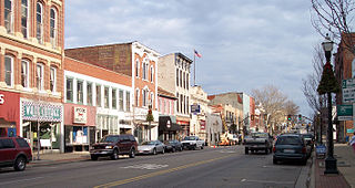
Maysville is a home rule-class city in Mason County, Kentucky, United States, and is the seat of Mason County. The population was 8,873 as of the 2020 census. Maysville is on the Ohio River, 66 miles (106 km) northeast of Lexington. It is the principal city of the Maysville Micropolitan Statistical Area, which comprises Mason County. Two bridges cross the Ohio from Maysville to Aberdeen, Ohio: the Simon Kenton Memorial Bridge built in 1931 and the William H. Harsha Bridge built in 2001.

Zanesville is a city in and the county seat of Muskingum County, Ohio, United States. Located at the confluence of the Licking and Muskingum rivers, the city is approximately 52 miles (84 km) east of Columbus and had a population of 24,765 as of the 2020 census, down from 25,487 as of the 2010 census. Historically the state capital of Ohio from 1810 to 1812, Zanesville anchors the Zanesville micropolitan area and is part of the greater Columbus-Marion-Zanesville combined statistical area.

Chillicothe is a city in and the county seat of Ross County, Ohio, United States. Located along the Scioto River 45 miles (72 km) south of Columbus, Chillicothe was the first and third capital of Ohio. It is the only city in Ross County and is the center of the Chillicothe micropolitan area. The population was 22,059 at the 2020 census. Chillicothe is a designated Tree City USA by the National Arbor Day Foundation.
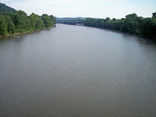
The Muskingum River is a tributary of the Ohio River, approximately 111 miles (179 km) long, in southeastern Ohio in the United States. An important commercial route in the 19th century, it flows generally southward through the eastern hill country of Ohio. Via the Ohio, it is part of the Mississippi River watershed. The river is navigable for much of its length through a series of locks and dams.

U.S. Route 40 or U.S. Highway 40 (US 40), also known as the Main Street of America, is a major east–west United States Highway traveling across the United States from the Mountain States to the Mid-Atlantic States. As with most routes whose numbers end in a zero, US 40 once traversed the entire United States. It is one of the first U.S. Highways created in 1926 and its original termini were in San Francisco, California, and Atlantic City, New Jersey. US 40 currently ends at a junction with I-80 in Silver Summit, Utah, just outside Salt Lake City. West of this point US 40 was functionally replaced with I-80, and as these segments of I-80 were constructed the western portion of US 40 was truncated several times.

The Ohio Lands were the several grants, tracts, districts and cessions which make up what is now the U.S. state of Ohio. The Ohio Country was one of the first settled parts of the Midwest, and indeed one of the first settled parts of the United States beyond the original Thirteen Colonies. The land that became first the anchor of the Northwest Territory and later Ohio was cobbled together from a variety of sources and owners.

Ebenezer Zane was an American pioneer, soldier, politician, road builder and land speculator. Born in the Colony of Virginia, Zane established a settlement near Fort Henry which became Wheeling, on the Ohio River. He also blazed an early road through the Ohio Country to Limestone known as Zane's Trace.
The Central Ohio Railroad was the third railroad to enter Columbus, Ohio, and the first to connect Columbus with the east coast. It eventually became a part of the Baltimore and Ohio Railroad.
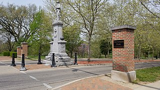
Yoctangee Park is a public park in Chillicothe, Ohio, adjacent to the Historic First Capital District. City Park was the official name of the park from its establishment in 1875 until it was changed to Yoctangee Park sometime in the 1890s by William H. Hunter.

Duncan Falls is a census-designated place in southeastern Wayne Township, Muskingum County, Ohio, United States, located on State Route 60 south of the city of Zanesville. It has a post office with the ZIP Code 43734. Duncan Falls has a public library, a branch of the Muskingum County Library System. The population was 898 at the 2020 census.

State Route 719 is a very short east–west state highway located in central Ohio, a U.S. state. Situated within the southernmost sections of the city of Zanesville as well as parts of South Zanesville and Springfield Township, SR 719 is a four-lane undivided route whose primary purpose is to connect the concurrency of US 22 and SR 93 at its western end with SR 555 at its eastern end, which, in turn, meets SR 60 just across the Muskingum River from SR 719's eastern terminus.

John McIntire was the founder of the city of Zanesville, Ohio.
The Ohio State League was a minor league baseball league that operated in numerous seasons between 1887 and 1947, predominantly as a Class D level league. League franchises were based in Indiana, Kentucky, Michigan, Ohio and West Virginia.
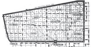
The United States Military District was a land tract in central Ohio that was established by the Congress to compensate veterans of the American Revolutionary War for their service. The tract contains 2,539,110 acres (10,275.4 km2) in Noble, Guernsey, Tuscarawas, Muskingum, Coshocton, Holmes, Licking, Knox, Franklin, Delaware, Morrow, and Marion counties.

The Congress Lands East of Scioto River was a land tract in southern Ohio that was established by the Congress late in the 18th century. It is located south of the United States Military District and Refugee Tract, west of the Old Seven Ranges, east of the Virginia Military District and north of the Ohio River, French Grant, and the Ohio Company of Associates.

Zane's Tracts were three parcels of land in the Northwest Territory of the United States, later Ohio, that the federal government granted to Ebenezer Zane late in the 18th century, as compensation for establishing a road with ferry service over several rivers.
This is a list of high school athletic conferences in the East and Southeast Regions of Ohio, as defined by the OHSAA. Because the names of localities and their corresponding high schools do not always match and because there is often a possibility of ambiguity with respect to either the name of a locality or the name of a high school, the following table gives both in every case, with the locality name first, in plain type, and the high school name second in boldface type. The school's team nickname is given last.
This is a list of former high school athletic conferences in the East and Southeast Regions of Ohio, as designated by the OHSAA. If a conference had members that span multiple regions, the conference is placed in the article of the region most of its former members hail from. Because the names of localities and their corresponding high schools do not always match and because there is often a possibility of ambiguity with respect to either the name of a locality or the name of a high school, the following table gives both in every case, with the locality name first, in plain type, and the high school name second in boldface type. The school's team nickname is given last, followed by the school colors listed as (p,s)


