
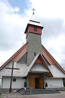
Szaflary is a village in southern Poland situated in the Lesser Poland Voivodeship since 1999. Szaflary has about 2,200 residents. There is a church, a fire station, and a few grocery stores in the village. The village lies along the Dunajec River.
Gmina Czarny Dunajec is a rural gmina in Nowy Targ County, Lesser Poland Voivodeship, in southern Poland, on the Slovak border. Its seat is the village of Czarny Dunajec, which lies approximately 13 kilometres (8 mi) west of Nowy Targ and 70 km (43 mi) south of the regional capital Kraków.

Mochnaczka Wyżna is a village in the administrative district of Gmina Krynica-Zdrój, within Nowy Sącz County, Lesser Poland Voivodeship, in southern Poland, close to the border with Slovakia. It lies approximately 5 kilometres (3 mi) north-east of Krynica-Zdrój, 29 km (18 mi) south-east of Nowy Sącz, and 102 km (63 mi) south-east of the regional capital Kraków.

Polany is a village in the administrative district of Gmina Krynica-Zdrój, within Nowy Sącz County, Lesser Poland Voivodeship, in southern Poland, close to the border with Slovakia. It lies approximately 14 kilometres (9 mi) north of Krynica-Zdrój, 23 km (14 mi) south-east of Nowy Sącz, and 96 km (60 mi) south-east of the regional capital Kraków.
Ciche is a village in the administrative district of Gmina Czarny Dunajec, within Nowy Targ County, Lesser Poland Voivodeship, in southern Poland, close to the border with Slovakia. It lies approximately 16 kilometres (10 mi) south-west of Nowy Targ and 76 km (47 mi) south of the regional capital Kraków.
Dział is a village in the administrative district of Gmina Czarny Dunajec, within Nowy Targ County, Lesser Poland Voivodeship, in southern Poland, close to the border with Slovakia. It lies approximately 9 kilometres (6 mi) north-east of Czarny Dunajec, 9 km (6 mi) north-west of Nowy Targ, and 63 km (39 mi) south of the regional capital Kraków.

Chyżne, is a village in the administrative district of Gmina Jabłonka, within Nowy Targ County, Lesser Poland Voivodeship, in southern Poland, close to the border with Slovakia. It lies approximately 6 kilometres (4 mi) south of Jabłonka, 26 km (16 mi) west of Nowy Targ, and 73 km (45 mi) south of the regional capital Kraków. The village has a population of 1,200.

Długopole is a village in the administrative district of Gmina Nowy Targ, within Nowy Targ County, Lesser Poland Voivodeship, in southern Poland. It lies approximately 7 kilometres (4 mi) west of Nowy Targ and 65 km (40 mi) south of the regional capital Kraków.

Harklowa is a village in the administrative district of Gmina Nowy Targ, within Nowy Targ County, Lesser Poland Voivodeship, in southern Poland. It lies approximately 11 kilometres (7 mi) east of Nowy Targ and 68 km (42 mi) south of the regional capital Kraków.

Klikuszowa is a village in the administrative district of Gmina Nowy Targ, within Nowy Targ County, Lesser Poland Voivodeship, in southern Poland. It lies approximately 7 kilometres (4 mi) north-west of Nowy Targ and 61 km (38 mi) south of the regional capital Kraków.
Krauszów is a village in the administrative district of Gmina Nowy Targ, within Nowy Targ County, Lesser Poland Voivodeship, in southern Poland. It lies approximately 5 kilometres (3 mi) north-west of Nowy Targ and 65 km (40 mi) south of the regional capital Kraków.

Lasek is a village in the administrative district of Gmina Nowy Targ, within Nowy Targ County, Lesser Poland Voivodeship, in southern Poland. It lies approximately 7 kilometres (4 mi) north-west of Nowy Targ and 61 km (38 mi) south of the regional capital Kraków.
Morawczyna is a village in the administrative district of Gmina Nowy Targ, within Nowy Targ County, Lesser Poland Voivodeship, in southern Poland. It lies approximately 7 kilometres (4 mi) north-west of Nowy Targ and 63 km (39 mi) south of the regional capital Kraków.

Sieniawa is a village in the administrative district of Gmina Raba Wyżna, within Nowy Targ County, Lesser Poland Voivodeship, in southern Poland. It lies approximately 5 kilometres (3 mi) south-east of Raba Wyżna, 10 km (6 mi) north-west of Nowy Targ, and 59 km (37 mi) south of the regional capital Kraków.
Bańska Niżna is a village in the administrative district of Gmina Szaflary, within Nowy Targ County, Lesser Poland Voivodeship, in southern Poland. It lies approximately 4 kilometres (2 mi) south of Szaflary, 8 km (5 mi) south of Nowy Targ, and 74 km (46 mi) south of the regional capital Kraków.
Bańska Wyżna is a village in the administrative district of Gmina Szaflary, within Nowy Targ County, Lesser Poland Voivodeship, in southern Poland. It lies approximately 6 kilometres (4 mi) south-west of Szaflary, 8 km (5 mi) south of Nowy Targ, and 74 km (46 mi) south of the regional capital Kraków.
Maruszyna is a village in the administrative district of Gmina Szaflary, within Nowy Targ County, Lesser Poland Voivodeship, in southern Poland. It lies approximately 6 kilometres (4 mi) west of Szaflary, 7 km (4 mi) south-west of Nowy Targ, and 72 km (45 mi) south of the regional capital Kraków.
Skrzypne is a village in the administrative district of Gmina Szaflary, within Nowy Targ County, Lesser Poland Voivodeship, in southern Poland. It lies approximately 8 kilometres (5 mi) south-west of Szaflary, 9 km (6 mi) south-west of Nowy Targ, and 74 km (46 mi) south of the regional capital Kraków.
Rudka is a village in the administrative district of Gmina Trzcianka, within Czarnków-Trzcianka County, Greater Poland Voivodeship, in west-central Poland. It lies approximately 8 kilometres (5 mi) south of Trzcianka, 13 km (8 mi) north-west of Czarnków, and 72 km (45 mi) north-west of the regional capital Poznań.


