Rostki is a village in the administrative district of Gmina Troszyn, within Ostrołęka County, Masovian Voivodeship, in east-central Poland. It lies approximately 4 kilometres (2 mi) south of Troszyn, 15 km (9 mi) south-east of Ostrołęka, and 101 km (63 mi) north-east of Warsaw. The village has a population of 60.

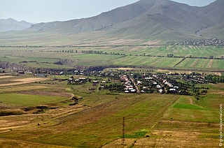
Amrakits formerly known as Nikolayevka and later as Kirov, is a village in the Lori Province of Armenia.

Ostrowsko is a village in the administrative district of Gmina Uniejów, within Poddębice County, Łódź Voivodeship, in central Poland. It lies approximately 5 kilometres (3 mi) north-west of Uniejów, 18 km (11 mi) north-west of Poddębice, and 54 km (34 mi) north-west of the regional capital Łódź.

Biskupice is a village in the administrative district of Gmina Miechów, within Miechów County, Lesser Poland Voivodeship, in southern Poland. It lies approximately 4 kilometres (2 mi) west of Miechów and 33 km (21 mi) north of the regional capital Kraków.

Przegrody is a village in the administrative district of Gmina Łopuszno, within Kielce County, Świętokrzyskie Voivodeship, in south-central Poland. It lies approximately 6 kilometres (4 mi) north of Łopuszno and 30 km (19 mi) north-west of the regional capital Kielce.

Wólka-Mogielnica, also known as Mogielnica, is a settlement in the administrative district of Gmina Słupia Konecka, within Końskie County, Świętokrzyskie Voivodeship, in south-central Poland.

Mrowina is a village in the administrative district of Gmina Kluczewsko, within Włoszczowa County, Świętokrzyskie Voivodeship, in south-central Poland. It lies approximately 9 kilometres (6 mi) north-west of Kluczewsko, 18 km (11 mi) north-west of Włoszczowa, and 54 km (34 mi) west of the regional capital Kielce.

Fijałkowo is a village in the administrative district of Gmina Przasnysz, within Przasnysz County, Masovian Voivodeship, in east-central Poland. It lies approximately 8 kilometres (5 mi) east of Przasnysz and 87 km (54 mi) north of Warsaw.

Orchówek is a village in the administrative district of Gmina Orchowo, within Słupca County, Greater Poland Voivodeship, in west-central Poland. It lies approximately 4 kilometres (2 mi) south of Orchowo, 23 km (14 mi) north-east of Słupca, and 74 km (46 mi) east of the regional capital Poznań.

Wołogoszcz is a village in the administrative district of Gmina Dobiegniew, within Strzelce-Drezdenko County, Lubusz Voivodeship, in western Poland. It lies approximately 7 kilometres (4 mi) north-east of Dobiegniew, 25 km (16 mi) north-east of Strzelce Krajeńskie, and 50 km (31 mi) north-east of Gorzów Wielkopolski.

Mielno is a village in the administrative district of Gmina Przewóz, within Żary County, Lubusz Voivodeship, in western Poland, close to the German border. It lies approximately 14 kilometres (9 mi) south-west of Żary and 57 km (35 mi) south-west of Zielona Góra.

Poljańska is a settlement in the administrative district of Gmina Sierakowice, within Kartuzy County, Pomeranian Voivodeship, in northern Poland. It lies approximately 7 kilometres (4 mi) east of Sierakowice, 14 km (9 mi) west of Kartuzy, and 42 km (26 mi) west of the regional capital Gdańsk.

Lipka is a settlement in the administrative district of Gmina Sztum, within Sztum County, Pomeranian Voivodeship, in northern Poland. It lies approximately 3 kilometres (2 mi) west of Sztum and 56 km (35 mi) south-east of the regional capital Gdańsk.
Ernstowo is a village in the administrative district of Gmina Wydminy, within Giżycko County, Warmian-Masurian Voivodeship, in northern Poland.
Wólka Pilecka is a village in the administrative district of Gmina Reszel, within Kętrzyn County, Warmian-Masurian Voivodeship, in northern Poland.
Vibyholm Castle is a castle in Årdala, Flen Municipality, Sweden. It was built in 1622-1626 by Dutchman Casper van Panten in Dutch High Renaissance style.

Kumarevo is a village in the municipality of Leskovac, Serbia. According to the 2002 census, the village has a population of 825 people.
Ridaküla is a village in Kadrina Parish, Lääne-Viru County, in northern Estonia. It is located on the Tapa–Loobu road, about 5 km (3 mi) northeast of the town of Tapa. Ridaküla is bordered by the Tallinn–Tapa–Narva railway to the southeast and the Valgejõgi River to the southwest.
Väike-Rahula is a village in Saaremaa Parish, Saare County in western Estonia.

Estadio Universitario BUAP is a multi-purpose stadium located in Ciudad Universitaria in Puebla, Puebla, Mexico. It is used by the Lobos BUAP professional football team, currently playing in the Liga MX top flight of Mexican football.


