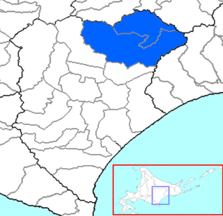
Ashoro is a district located in Tokachi Subprefecture, Hokkaido, Japan.
The Municipal Hospital is the main hospital in Luxembourg City, in southern Luxembourg. It is located off the Route d'Arlon N6 road, in Rollingergrund, in the west of the city. The hospital forms the largest part of the Centre Hospitalier de Luxembourg, the public sector healthcare provider in Luxembourg City.

Lasek is a village in the administrative district of Gmina Tuchola, within Tuchola County, Kuyavian-Pomeranian Voivodeship, in north-central Poland. It lies approximately 16 kilometres (10 mi) north of Tuchola and 69 km (43 mi) north of Bydgoszcz.
Lipce is a village in the administrative district of Gmina Tuchola, within Tuchola County, Kuyavian-Pomeranian Voivodeship, in north-central Poland. It lies approximately 16 kilometres (10 mi) north of Tuchola and 69 km (43 mi) north of Bydgoszcz.
Nowe Sypnie is a village in the administrative district of Gmina Grodzisk, within Siemiatycze County, Podlaskie Voivodeship, in north-eastern Poland. It lies approximately 5 kilometres (3 mi) north-west of Grodzisk, 25 km (16 mi) north-west of Siemiatycze, and 64 km (40 mi) south-west of the regional capital Białystok.

Baldırğanlı is a village in the Lachin Rayon of Azerbaijan.
Olendry is a village in the administrative district of Gmina Grabica, within Piotrków County, Łódź Voivodeship, in central Poland.
Łochów Nowy is a village in the administrative district of Gmina Żelechlinek, within Tomaszów Mazowiecki County, Łódź Voivodeship, in central Poland. It lies approximately 5 kilometres (3 mi) north-east of Żelechlinek, 25 km (16 mi) north of Tomaszów Mazowiecki, and 44 km (27 mi) east of the regional capital Łódź.
Brondy is a village in the administrative district of Gmina Szadek, within Zduńska Wola County, Łódź Voivodeship, in central Poland.
Wola Krokocka is a village in the administrative district of Gmina Szadek, within Zduńska Wola County, Łódź Voivodeship, in central Poland. It lies approximately 4 kilometres (2 mi) north of Szadek, 15 km (9 mi) north of Zduńska Wola, and 34 km (21 mi) west of the regional capital Łódź.
Ulaski Gostomskie is a village in the administrative district of Gmina Mogielnica, within Grójec County, Masovian Voivodeship, in east-central Poland.
Pianowo-Bargły is a village in the administrative district of Gmina Nasielsk, within Nowy Dwór Mazowiecki County, Masovian Voivodeship, in east-central Poland.
Stare Rzewuski is a large village in the administrative district of Gmina Przesmyki, within Siedlce County, Masovian Voivodeship, in east-central Poland.
Cieśle is a village in the administrative district of Gmina Buk, within Poznań County, Greater Poland Voivodeship, in west-central Poland. It lies approximately 8 kilometres (5 mi) east of Buk and 21 km (13 mi) west of the regional capital Poznań.
Osetnik is a settlement in the administrative district of Gmina Choczewo, within Wejherowo County, Pomeranian Voivodeship, in northern Poland. It lies approximately 12 kilometres (7 mi) north-west of Choczewo, 40 km (25 mi) north-west of Wejherowo, and 75 km (47 mi) north-west of the regional capital Gdańsk.
Leszczynka Mała is a village in the administrative district of Gmina Małdyty, within Ostróda County, Warmian-Masurian Voivodeship, in northern Poland. It lies approximately 6 kilometres (4 mi) south of Małdyty, 25 km (16 mi) north-west of Ostróda, and 52 km (32 mi) west of the regional capital Olsztyn.
Sąpolnica is a village in the administrative district of Gmina Nowogard, within Goleniów County, West Pomeranian Voivodeship, in north-western Poland. It lies approximately 6 kilometres (4 mi) south-east of Nowogard, 24 km (15 mi) east of Goleniów, and 44 km (27 mi) north-east of the regional capital Szczecin.
Opatówek is a village in the administrative district of Gmina Bobolice, within Koszalin County, West Pomeranian Voivodeship, in north-western Poland. It lies approximately 4 kilometres (2 mi) south-east of Bobolice, 41 km (25 mi) south-east of Koszalin, and 146 km (91 mi) north-east of the regional capital Szczecin.
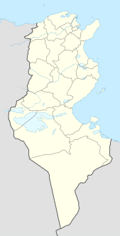
Bir Ali Ben Khélifa is a town and commune in eastern Tunisia in the Sfax Governorate. It lies 60 kilometres from Sfax. As of 2004 the town had a population of 4460.
The Taubenklippe is a rock formation in the Harz mountains in the German state of Saxony-Anhalt. It lies about halfway between Bad Harzburg and Ilsenburg at a height of 572 m above NN on the eastern slopes of the Ecker valley. From the crag there is a good view over Harz Foreland, the heights near Bad Harzburg and the highest mountain in the Har, the Brocken. The Taubenklippe may be reached from the Ecker valley on a footpath, some 6 km long, that starts in Ilsenburg.


