
Qatar is a peninsula in the east of Arabia, bordering the Persian Gulf and Saudi Arabia, in a strategic location near major petroleum and natural gas deposits. The State of Qatar occupies 11,571 km2 (4,468 sq mi) on a peninsula that extends approximately to 160 km (99 mi) north into the Persian Gulf from the Arabian Peninsula.

The Niagara Escarpment is a long escarpment, or cuesta, in Canada and the United States that starts from the south shore of Lake Ontario westward, circumscribes the top of the Great Lakes Basin running from New York through Ontario, Michigan, and Wisconsin. The escarpment is the cliff over which the Niagara River plunges at Niagara Falls, for which it is named.

Jiuzhaigou is a nature reserve and national park located in the north of Sichuan Province in southwestern China. A long valley running north to south, Jiuzhaigou was inscribed by UNESCO as a World Heritage Site in 1992 and a World Biosphere Reserve in 1997. It belongs to the category V in the IUCN system of protected area categorization.

Monte Grappa is a mountain of the Venetian Prealps in Veneto, Italy. It lies between the Venetian plain to the south and the central alpine areas to the North. To the west, it is parted from the Asiago upland by the Brenta river, and to the east it is separated from the Cesen-Visentin massif by the Piave river. To the north lie Corlo lake and Feltre valley. In the past, the mountain was called Alpe Madre, and is currently divided among three provinces: Vicenza to the west, Treviso to the south and Belluno to the northeast. It is the highest peak of a small massif, which also includes many other peaks such as Col Moschin, Colle della Berretta, Monte Asolone, Monte Pertica, Prassolan, Monti Solaroli, Fontana Secca, Monte Peurna, Monte Santo, Monte Tomatico, Meatte, Monte Pallon, and Monte Tomba.
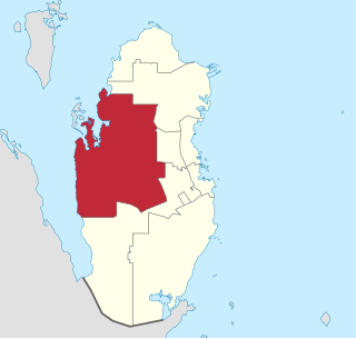
Al Shahaniya is a municipality (3299 km2) in Qatar, with its municipal seat being a city of the same name (39 km2). Formerly in the municipality of Al Rayyan, but now an independent municipality, the municipal seat was delimited in 1988 by Law No. 22. In 2014, the cabinet ratified a draft amending provisions to the 1988 law that formalized Al Shahaniya as Qatar's eighth municipality.

The Stone Forest or Shilin is a notable set of limestone formations about 500 km2 located in Shilin Yi Autonomous County, Yunnan Province, People's Republic of China, near Shilin approximately 90 km (56 mi) from the provincial capital Kunming.
Protected areas of Qatar include:

Dukhan is a city in the western municipality of Al-Shahaniya in Qatar. It is approximately 80 kilometres (50 mi) west of the capital, Doha. Dukhan is administered by Qatar's state oil agency QatarEnergy and is the site of the first oil discovery in Qatar. It was previously a part of Al Rayyan municipality.
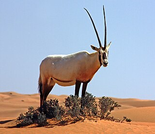
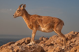
The wildlife of Qatar includes the peninsula's flora and fauna and their natural habitats. The country's terrestrial wildlife includes numerous small nocturnal mammals, a number of reptiles which mainly consist of lizard species, and arthropods. Aquatic animals primarily include fish, shrimp and pearl oysters. The desert and the shoreline form an important resting site for migratory bird species during autumn and spring. Urban and agricultural developments have led to an increase in bird species.

Archaeology of Qatar as a field study began in 1956. Three major expeditions were carried out in Qatar throughout the mid-20th century, with the first being launched by a Danish team who began work in the 1950s. This was followed by British and French expeditions in 1970s and 1980s, respectively. Approximately 200 archaeological sites were discovered during these expeditions, with the most extensive being the coastal areas of Al Da'asa, Ras Abrouq and Al Khor Island. Artifacts such as flint tools, Ubaid and Barbar pottery and encampments were found in situ.

Ras Abrouq is the northernmost extension of the Zekreet Peninsula, a stretch of land to the north of Dukhan in Qatar. It has a beach of the same name and various archaeological sites. Since the 21st century it has functioned as a tourist site.
Qatar is a peninsula on the northeastern coast of the Arabian Peninsula, bordering Saudi Arabia to the south and surrounded elsewhere by the Persian Gulf. A strait separates Qatar from the island kingdom of Bahrain.

The flora of Qatar includes more than 300 species of wild plants. Qatar occupies a small desert peninsula that is around 80 km from east to west and 160 km from north to south. The climate is hot and humid with sporadic rain. Majority of the country is flat with an annual rainfall average of less than 3 inches. Arnebia hispidissim blooms yellow flowers annually in sandy soil. Glossonema edule has edible fruits with brownish-yellow flowers.

Zekreet is a village in north-western Qatar near Dukhan and about 80 km (50 mi) north-west west of Doha. Originally a sparsely populated area, Zekreet was built up in the 1940s after oil operations commenced in Qatar. This included the construction of a harbor for oil equipment and a number of small houses which eventually developed into a village. There are a number of visitor attractions and old ruins at the site, one of the most notable being Zekreet Fort, which is housed to the immediate north of the village.
Umm Al Daah Khawzan is a village in Qatar located in the municipality of Al-Shahaniya. It is accessible through Dukhan Road. The closest city is the industrial hub of Dukhan. According to the Ministry of Environment, there were about six households in the village in 2014.
The geology of the United Arab Emirates includes very thick Paleozoic, Mesozoic and Cenozoic marine and continental sedimentary rocks overlying deeply buried Precambrian. The region has extensive oil and gas resources and was deformed during the last several million years by more distant tectonic events.
The geology of Saudi Arabia includes Precambrian igneous and metamorphic basement rocks, exposed across much of the country. Thick sedimentary sequences from the Phanerozoic dominate much of the country's surface and host oil.
Zone 72 is a zone in the municipality of Al-Shahaniya in the state of Qatar. The main district recorded in the 2015 population census was Al Utouriya.
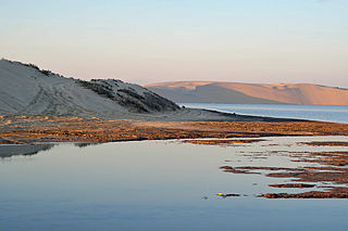
The Bay of Zekreet is a half-moon shaped bay on the Zekreet Peninsula in western Qatar. The Zekreet Peninsula is a rocky, sandy desert, with numerous rock formations and gypsum plateaux. The bay is situated to the north of the industrial city of Dukhan and to the southwest of the village of Zekreet. It is located to the north of the Dukhan Sabkha, and is separated by a straight depression known as Rawdat Jarrah. Geologists have theorized that this depression was an extension of the Bay of Zekreet prior to the drop in sea levels c. 3,000 years ago.

