Zell, Carinthia

Last updated
Zell

Sele
Zell Pfarre 25052007 04.jpg
Wappen at zell.png
Coat of arms
Austria Carinthia location map.svg
Red pog.svg
Zell
Location within Austria
Austria adm location map.svg
Red pog.svg
Zell
Zell (Austria)
Coordinates: 46°28′N14°23′E / 46.467°N 14.383°E / 46.467; 14.383 Coordinates: 46°28′N14°23′E / 46.467°N 14.383°E / 46.467; 14.383
Country Austria
State Carinthia
District Klagenfurt-Land
Government
   Mayor Engelbert Wassner (SPÖ)
Area
[1]
  Total75.3 km2 (29.1 sq mi)
Elevation
948 m (3,110 ft)
Population
(2018-01-01) [2]
  Total609
  Density8.1/km2 (21/sq mi)
Time zone UTC+1 (CET)
  Summer (DST) UTC+2 (CEST)
Postal code
9170
Area code 04227
Website www.zell-sele.at

Zell (Slovene : Sele) is a municipality in the district of Klagenfurt-Land in the Austrian state of Carinthia.

Slovene language language spoken in Slovenia

Slovene or Slovenian belongs to the group of South Slavic languages. It is spoken by approximately 2.5 million speakers worldwide, the majority of whom live in Slovenia. It is the first language of about 2.1 million Slovenian people and is one of the 24 official and working languages of the European Union.

Austria Federal republic in Central Europe

Austria, officially the Republic of Austria, is a country in Central Europe comprising 9 federated states. Its capital, largest city and one of nine states is Vienna. Austria has an area of 83,879 km2 (32,386 sq mi), a population of nearly 9 million people and a nominal GDP of $477 billion. It is bordered by the Czech Republic and Germany to the north, Hungary and Slovakia to the east, Slovenia and Italy to the south, and Switzerland and Liechtenstein to the west. The terrain is highly mountainous, lying within the Alps; only 32% of the country is below 500 m (1,640 ft), and its highest point is 3,798 m (12,461 ft). The majority of the population speaks local Bavarian dialects as their native language, and German in its standard form is the country's official language. Other regional languages are Hungarian, Burgenland Croatian, and Slovene.

Contents

Geography

Zell lies in a side valley on the north of the Karawank on the Slovenian border about 20 km south of Klagenfurt and 6 km south of Ferlach.

Slovenia republic in Central Europe

Slovenia, officially the Republic of Slovenia, is a sovereign state located in southern Central Europe at a crossroads of important European cultural and trade routes. It is bordered by Italy to the west, Austria to the north, Hungary to the northeast, Croatia to the southeast, and the Adriatic Sea to the southwest. It covers 20,273 square kilometers (7,827 sq mi) and has a population of 2.07 million. One of the successor states of the former Yugoslavia, Slovenia is a parliamentary republic and a member of the United Nations, of the European Union, and of NATO. The capital and largest city is Ljubljana.

Klagenfurt Place in Carinthia, Austria

Klagenfurt am Wörthersee is the capital of the federal state of Carinthia in Austria. With a population of 100,772, it is the sixth-largest city in the country. The city is the bishop's seat of the Roman Catholic Diocese of Gurk-Klagenfurt and home to the University of Klagenfurt.

Ferlach Place in Carinthia, Austria

Ferlach in the district of Klagenfurt-Land in Carinthia is the southernmost town in Austria. It is known for its centuries-old gunsmith tradition, part of the Austrian intangible cultural heritage since 2010.
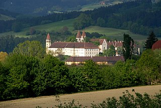
Population

According to the 2001 census, 89.1% of the inhabitants are of Carinthian Slovenian descent, which is the highest percentage of all municipalities in the state of Carinthia.

Carinthian Slovenes or Carinthian Slovenians are the indigenous Slovene-speaking population group in the Austrian state of Carinthia. They send representatives to the National Ethnic Groups Advisory Council. The status of the minority group is guaranteed in principle by the Constitution of Austria and under international law.

The commune is situated southwest of the town of Ferlach, on the northern slope of the Koschuta Massif within the Karawanks mountain range. The place was first mentioned as Cel in a 1280 deed. It consists of six villages:

Karawanks mountain range

The Karawanks or Karavankas or Karavanks are a mountain range of the Southern Limestone Alps on the border between Slovenia to the south and Austria to the north. With a total length of 120 kilometres (75 mi) in an east-west direction, the Karawanks chain is one of the longest ranges in Europe. It is traversed by important trade routes and has a great tourist significance. Geographically and geologically, it is divided into the higher Western Karawanks and the lower-lying Eastern Karawanks. It is traversed by the Periadriatic Seam, separating the Apulian tectonic plate from the Eurasian Plate.

Village (German)Village (Slovenian)Number of people 1991Percent of Slovenes 1991Percent of Slovenes 1951
Zell FreibachSele Borovnica18792.5%96.9%
Zell HomölischSele Hmelše2347.8%76.3%
Zell MitterwinkelSele Srednji Kot9898%95.7%
Zell OberwinkelSele Zvrhnji Kot9196.7%97.1%
Zell PfarreSele Fara23593.2%92.1%
Zell SchaidaSele Šajda10099%91.7%

Politics

Seats in the municipal council (2003 elections):

Related Research Articles

Ebenthal Place in Carinthia, Austria

Ebenthal is a town in the district of Klagenfurt-Land in the Austrian state of Carinthia.

Feistritz im Rosental Place in Carinthia, Austria

Feistritz im Rosental is a market town in the district of Klagenfurt-Land in the Austrian state of Carinthia.

Grafenstein Place in Carinthia, Austria

Grafenstein is a town in the district of Klagenfurt-Land in the Austrian state of Carinthia.

Keutschach am See Place in Carinthia, Austria

Keutschach am See is a municipality in the district of Klagenfurt-Land in the Austrian state of Carinthia.

Köttmannsdorf Place in Carinthia, Austria

Köttmannsdorf is a town in the district of Klagenfurt-Land in the Austrian state of Carinthia.

Krumpendorf Place in Carinthia, Austria

Krumpendorf am Wörthersee is a municipality in Klagenfurt-Land District, in Carinthia, Austria.

Ludmannsdorf Place in Carinthia, Austria

Ludmannsdorf is a town in the district of Klagenfurt-Land in the Austrian state of Carinthia.

Maria Rain Place in Carinthia, Austria

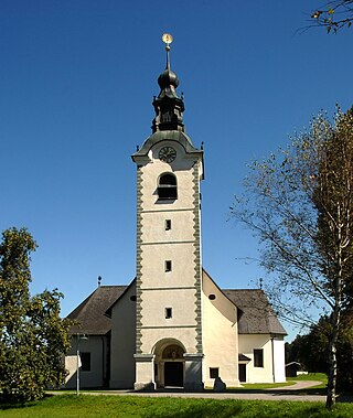
Maria Rain is a town in the district of Klagenfurt-Land in the Austrian state of Carinthia, known for its Baroque parish and pilgrimage church.

Sankt Margareten im Rosental Place in Carinthia, Austria

Sankt Margareten im Rosental is a town in the district of Klagenfurt-Land in the Austrian state of Carinthia.

Techelsberg Place in Carinthia, Austria

Techelsberg is a town in the district of Klagenfurt-Land in the Austrian state of Carinthia.

Kappel am Krappfeld Place in Carinthia, Austria

Kappel am Krappfeld is a town in the district of Sankt Veit an der Glan in the Austrian state of Carinthia. It is the birthplace of Maria Lassnig.

Liebenfels Place in Carinthia, Austria

Liebenfels is a market town in the district of Sankt Veit an der Glan in the Austrian state of Carinthia.

Mölbling Place in Carinthia, Austria

Mölbling is a municipality on the Gurk River in the district of Sankt Veit an der Glan in the Austrian state of Carinthia.

Sankt Georgen am Längsee Place in Carinthia, Austria

Sankt Georgen am Längsee is a municipality in the district of Sankt Veit an der Glan in Carinthia, Austria.

Finkenstein am Faaker See Place in Carinthia, Austria

Finkenstein am Faaker See is a market town in the district of Villach-Land in Carinthia, Austria.

Sankt Jakob im Rosental Place in Carinthia, Austria

Sankt Jakob im Rosental is a town in the district of Villach-Land in the Austrian state of Carinthia.

Eberndorf Place in Carinthia, Austria

Eberndorf is a market town of the Völkermarkt District in Carinthia, Austria.

Neuhaus, Carinthia Place in Carinthia, Austria

Neuhaus is a small town in the Austrian state of Carinthia southeast of Klagenfurt, in the district of Völkermarkt, about 4 km from the border with Slovenia.

Sittersdorf Place in Carinthia, Austria

Sittersdorf is a town in the district of Völkermarkt in Carinthia in south-central Austria.

References

  1. "Dauersiedlungsraum der Gemeinden Politischen Bezirke und Bundesländer - Gebietsstand 1.1.2018". Statistics Austria. Retrieved 10 March 2019.
  2. "Einwohnerzahl 1.1.2018 nach Gemeinden mit Status, Gebietsstand 1.1.2018". Statistics Austria. Retrieved 9 March 2019.