Ferlach

Last updated
Ferlach
Borovlje
Ferlach Rosental und Ferlacher Horn 01082004 01.jpg
Wappen at ferlach.png
Austria Carinthia location map.svg
Red pog.svg
Ferlach
Location within Austria
Austria adm location map.svg
Red pog.svg
Ferlach
Ferlach (Austria)
Coordinates: 46°32′N14°18′E / 46.533°N 14.300°E / 46.533; 14.300 Coordinates: 46°32′N14°18′E / 46.533°N 14.300°E / 46.533; 14.300
Country Austria
State Carinthia
District Klagenfurt-Land
Government
   Bürgermeister Ingo Appé (SPÖ)
Area
[1]
  Total117.21 km2 (45.26 sq mi)
Elevation
466 m (1,529 ft)
Population
 (2018-01-01) [2]
  Total7,141
  Density61/km2 (160/sq mi)
Time zone UTC+1 (CET)
  Summer (DST) UTC+2 (CEST)
Postal code
9170
Area code 04227
Website www.ferlach.at

Ferlach (Slovene : Borovlje) in the district of Klagenfurt-Land in Carinthia is the southernmost town in Austria. It is known for its centuries-old gunsmith tradition, part of the Austrian intangible cultural heritage since 2010.

Contents

Geography

It is situated in the Rosental/Rož Valley of the Drava River, about 17 kilometres (11 mi) south of the Carinthian state capital Klagenfurt. In the south, the crest of the Karawanks mountain range forms the border with Slovenia. The municipal area comprises the cadastral communities of Ferlach (Borovlje), Kappel an der Drau (Kapla ob Dravi), Kirschentheuer (Kožentavra), Unterloibl (Podljubelj), Waidisch (Bajdiše), Unterferlach (Medborovnica), Glainach (Glinje), Seidolach (Ždovlje), and Windisch Bleiberg (Slovenji Plajberg).

The town centre lies at the junction of the Rosental Straße (B85) highway with Loiblpass Straße (B91), part of the European route E652, running from Klagenfurt to Tržič in Slovenia via Loibl Pass. The Ferlach Railway line from Weizelsdorf went out of service in 1951, but on summer weekends and special occasions a heritage railway service, the Rosentaler Dampfzug runs as far as Weizelsdorf, operated by the preservation group Nostalgiebahnen in Kärnten.

History

Ferlach was first mentioned as Vörelach in a 1246 deed, named after the surrounding pine (Föhre, bor in Slovene) forests. The mountainous area is the site of large iron ore deposits, ironworks and forging is documented since the 15th century.

The relocation of the capital of the Duchy of Carinthia to nearby Klagenfurt under the rule of King Maximilian I about 1518 decisively promoted the development of Ferlach as a centre of firearm manufacturing. Under Empress Maria Theresa, its gunsmiths became the main armorers of the Habsburg monarchy. Ferlach firearms were also used by the Spanish, French and Turkish armies.

The present-day municipality was established as Oberferlach in 1850. Ferlach received town privileges in 1930 and today is a centre for the production of hunting rifles. The history of the town is depicted in its coat of arms: it features a pine tree with a cone, two crossed silver nails, and a rifle.

Population

According to the 2011 census has Ferlach 7.272 inhabitants. 8.0% of the population are Carinthian Slovenes.

Ferlach Castle Ferlach Schloss 05.jpg
Ferlach Castle
VillageNumber of people 1991Percent of Slovenes 1991Percent of Slovenes 1951
Bodental/Poden11553.9%83.3%
Loibltal/Brodi7051.4%68.2%
Strugarjach/Strugarje1861.6%94.1%
W.Bleiberg/Slovenji Plajberk12466.9%87.3%
Waidisch/Bajdiše9337.6%44.5%
Glainach/Glinje11412.3%84.7%
Kappel a.D./Kapla ob Dravi2626.5%30.3%
Tratten/Trata8215.9%41.4%
Unterglainach/Vesca3237.5%100%
Laak/Loka4114.6%100%
Seidolach/Ždovlje8718.4%74.5%
Dörfl/Kajže1855.6%79.4%
Singerberg/Žingarica911.1%100%
Rauth/Rute119.1%100%
Görtschach/Goriče2308.8%13.7%
Reßnig/Resnica2127.1%44.8%
Kirschentheuer/Kožentavra2527.9%45.6%
Otrouza/Otrovca715.6%41.0%
Strau/Struga2225.0%28.5%
Unterloibl/Podljubelj2408.3%22.1%

Climate

Climate data for Ferlach
MonthJanFebMarAprMayJunJulAugSepOctNovDecYear
Record high °C (°F)13.8
(56.8)
21.8
(71.2)
24.8
(76.6)
27.0
(80.6)
31.4
(88.5)
32.8
(91.0)
36.5
(97.7)
36.0
(96.8)
31.0
(87.8)
26.2
(79.2)
18.8
(65.8)
17.8
(64.0)
36.5
(97.7)
Average high °C (°F)0.9
(33.6)
5.0
(41.0)
10.8
(51.4)
15.3
(59.5)
20.6
(69.1)
23.7
(74.7)
25.9
(78.6)
25.6
(78.1)
20.9
(69.6)
14.6
(58.3)
6.3
(43.3)
1.3
(34.3)
14.2
(57.6)
Daily mean °C (°F)−4.0
(24.8)
−1.4
(29.5)
3.5
(38.3)
8.2
(46.8)
13.5
(56.3)
16.7
(62.1)
18.6
(65.5)
18.1
(64.6)
13.7
(56.7)
8.2
(46.8)
1.7
(35.1)
−2.7
(27.1)
7.8
(46.0)
Average low °C (°F)−7.1
(19.2)
−5.4
(22.3)
−1.4
(29.5)
2.5
(36.5)
7.2
(45.0)
10.7
(51.3)
12.5
(54.5)
12.3
(54.1)
8.6
(47.5)
4.3
(39.7)
−1.1
(30.0)
−5.2
(22.6)
3.2
(37.7)
Record low °C (°F)−24.3
(−11.7)
−24.1
(−11.4)
−16.7
(1.9)
−6.0
(21.2)
−2.6
(27.3)
2.0
(35.6)
3.7
(38.7)
3.5
(38.3)
−1.4
(29.5)
−10.6
(12.9)
−15.0
(5.0)
−19.6
(−3.3)
−24.3
(−11.7)
Average rainfall mm (inches)51.9
(2.04)
50.4
(1.98)
70.3
(2.77)
99.1
(3.90)
104.0
(4.09)
134.0
(5.28)
137.0
(5.39)
120.1
(4.73)
122.6
(4.83)
118.0
(4.65)
114.7
(4.52)
80.0
(3.15)
1,202.1
(47.33)
Average snowfall cm (inches)28.9
(11.4)
33.7
(13.3)
19.1
(7.5)
10.8
(4.3)
0.2
(0.1)
0.0
(0.0)
0.0
(0.0)
0.0
(0.0)
0.0
(0.0)
0.8
(0.3)
13.8
(5.4)
29.2
(11.5)
136.5
(53.7)
Average rainy days (≥ 1.0 mm)5.85.17.59.311.412.011.49.88.58.37.86.8103.7
Average snowy days (≥ 1.0 cm)26.121.412.91.80.20.00.00.00.00.25.919.888.3
Mean monthly sunshine hours 78.8123.0158.3175.2212.5217.5241.2233.0180.5125.666.057.41,869
Source: [ citation needed ]

Politics

Seats in the municipal assembly (Gemeinderat) as of 2021 local elections:

Notable people

Related Research Articles

<span class="mw-page-title-main">Klagenfurt</span> Place in Carinthia, Austria

Klagenfurt am Wörthersee, usually known as just Klagenfurt, is the capital of the state of Carinthia in Austria. With a population of 103,009, it is the sixth-largest city in the country. The city is the bishop's seat of the Roman Catholic Diocese of Gurk-Klagenfurt and home to the University of Klagenfurt, the Carinthian University of Applied Sciences and the Gustav Mahler University of Music.

<span class="mw-page-title-main">Carinthia</span> State of Austria

Carinthia is the southernmost Austrian state, in the Eastern Alps, and is noted for its mountains and lakes. The main language is German. Its regional dialects belong to the Southern Bavarian group. Carinthian Slovene dialects, forms of a South Slavic language that predominated in the southeastern part of the region up to the first half of the 20th century, are now spoken by a small minority in the area.

<span class="mw-page-title-main">Völkermarkt</span> Place in Carinthia, Austria

Völkermarkt is a town of about 11,000 inhabitants in the Austrian state of Carinthia, the administrative capital of Völkermarkt District. It is located within the Drava valley east of the Carinthian capital Klagenfurt, north of the Karawanken mountain range.

<span class="mw-page-title-main">Spittal an der Drau</span> Place in Carinthia, Austria

Spittal an der Drau is a town in the western part of the Austrian federal state of Carinthia. It is the administrative centre of Spittal an der Drau District, Austria's second largest district (Bezirk) by area.

<span class="mw-page-title-main">Feldkirchen in Kärnten</span> Place in Carinthia, Austria

Feldkirchen in Kärnten is a town in the Austrian state of Carinthia and the capital of the district of the same name. It consists of the Katastralgemeinden Fasching, Feldkirchen, Glanhofen, Gradisch, Hoefling, Klein Sankt Veit, Pernegg, Rabensdorf, Sankt Ulrich, Sittich, Tschwarzen and Waiern. The name Feldkirchen means the church in the fields.

<span class="mw-page-title-main">Feistritz im Rosental</span> Town in Carinthia, Austria

Feistritz im Rosental, often referred to as simply Feistritz, is a market town in the district of Klagenfurt-Land in the Austrian state of Carinthia.
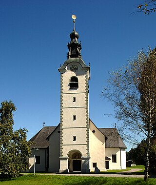
<span class="mw-page-title-main">Köttmannsdorf</span> Place in Carinthia, Austria

Köttmannsdorf is a town in the district of Klagenfurt-Land in the Austrian state of Carinthia.

<span class="mw-page-title-main">Maria Rain</span> Place in Carinthia, Austria

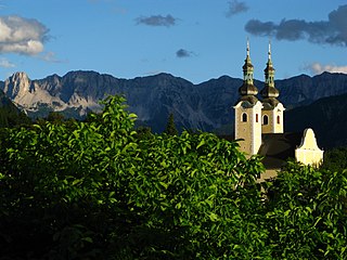
Maria Rain is a town in the district of Klagenfurt-Land in the Austrian state of Carinthia, known for its Baroque parish and pilgrimage church.

<span class="mw-page-title-main">Moosburg, Austria</span> Place in Carinthia, Austria

Moosburg is a market town in the Klagenfurt-Land district in the Austrian state of Carinthia.

<span class="mw-page-title-main">Pörtschach am Wörthersee</span> Place in Carinthia, Austria

Pörtschach am Wörthersee is a municipality in the district of Klagenfurt-Land in Carinthia, Austria. It is an established summer resort and lakeside town on Wörthersee.

<span class="mw-page-title-main">Sankt Margareten im Rosental</span> Place in Carinthia, Austria

Sankt Margareten im Rosental is a town in the district of Klagenfurt-Land in the Austrian state of Carinthia.

<span class="mw-page-title-main">Zell, Carinthia</span> Place in Carinthia, Austria

Zell is a municipality in the district of Klagenfurt-Land in the Austrian state of Carinthia.

<span class="mw-page-title-main">Oberdrauburg</span> Place in Carinthia, Austria

Oberdrauburg is a market town in the district of Spittal an der Drau at the western rim of the Austrian state of Carinthia.

<span class="mw-page-title-main">Arnoldstein</span> Place in Carinthia, Austria

Arnoldstein is a market town in the district of Villach-Land in the Austrian state of Carinthia.

<span class="mw-page-title-main">Finkenstein am Faaker See</span> Place in Carinthia, Austria

Finkenstein am Faaker See is a market town in the district of Villach-Land in Carinthia, Austria.

<span class="mw-page-title-main">Sankt Jakob im Rosental</span> Place in Carinthia, Austria

Sankt Jakob im Rosental is a town in the district of Villach-Land in the Austrian state of Carinthia.

<span class="mw-page-title-main">Eberndorf</span> Place in Carinthia, Austria

Eberndorf is a market town of the Völkermarkt District in Carinthia, Austria.

<span class="mw-page-title-main">Griffen, Austria</span> Place in Carinthia, Austria

Griffen is a market town in the district of Völkermarkt in the Austrian state of Carinthia.

<span class="mw-page-title-main">Neuhaus, Carinthia</span> Place in Carinthia, Austria

Neuhaus is a small town in the Austrian state of Carinthia southeast of Klagenfurt, in the district of Völkermarkt, about 4 km from the border with Slovenia.

The Rosen Valley Railway is a mainly Austrian railway that runs from Sankt Veit an der Glan via Klagenfurt and Rosenbach to Jesenice in Slovenia. The section between Rosenbach and Jesenice through the Karawanks Tunnel is part of and international long-distance route between Salzburg and Zagreb. The railway line is operated by the ÖBB. Traffic between Weizelsdorf and Rosenbach was suspended at the commencement 2016/17 timetable change. The line was sold to the state of Carinthia. NBIK heritage trains have been running between Weizelsdorf and Feistritz since the summer of 2020.

References

  1. "Dauersiedlungsraum der Gemeinden Politischen Bezirke und Bundesländer - Gebietsstand 1.1.2018". Statistics Austria. Retrieved 10 March 2019.
  2. "Einwohnerzahl 1.1.2018 nach Gemeinden mit Status, Gebietsstand 1.1.2018". Statistics Austria. Retrieved 9 March 2019.