This article may require cleanup to meet Wikipedia's quality standards. The specific problem is: Section headers.(September 2022) |
Zerzura (Arabic : زرزورة) is a legendary city or oasis located in the Sahara Desert.
This article may require cleanup to meet Wikipedia's quality standards. The specific problem is: Section headers.(September 2022) |
Zerzura (Arabic : زرزورة) is a legendary city or oasis located in the Sahara Desert.
Zerzura was long rumored to have existed deep in the desert west of the Nile River in Egypt or Libya. In writings dating back to the 13th century, the authors spoke of a city which was "white as a dove" and called it "The Oasis of Little Birds". [1] In the Kitab al Kanuz , Zerzura is said to be a city in the Sahara full of treasure with a sleeping king and queen. The city is guarded by black giants who keep anyone from going in and coming out. However, this may be a reference to the black Tebu people, nomads in Chad and Libya whose ancestors used to raid oases out in the Sahara.
"The first European reference to Zerzura is in an 1835 account by the English Egyptologist John Gardner Wilkinson, based on a report by an Arab who said he had found the oasis while searching for a lost camel. Placed five days west of the track connecting the oases of Farafra and Bahariya, the "Oasis called Wadee Zerzoora" abounded "in palms, with springs, and some ruins of uncertain date." Although tales of secret desert locales found by searchers for stray camels were common enough, Wilkinson's account was bolstered when later explorers found a number of previously unknown oases that had been named in his account along with Zerzura. But they did not find Zerzura itself." [2]
More recently, European explorers made forays into the desert in search of Zerzura but never succeeded in finding it. Notable twentieth-century explorers Ralph Bagnold of Britain, and the Hungarian László (Ladislaus) Almásy led an expedition to search for Zerzura from 1929–1930 using Ford Model A trucks. In 1932 the Almásy–Patrick Clayton expedition reconnaissance flights discovered two valleys in the Gilf Kebir. In the following year, Almásy found the third of the "Zerzura" wadis, actually rain oases in the remote desert. [3] On the other hand, Bagnold considered Zerzura as a legend that could never be solved by discovery. [4]
The participants of the Zerzura hunt created the Zerzura Club in a bar in Wadi Halfa upon their return in 1930. Many of the club's members remained friends and several went on to serve as officers in the British Army during World War II. Many served in the Long Range Desert Patrol during the North African Campaign. Only Almásy served Rommel's Afrika Korps and assisted the Italians. [5]
According to the historical writings from the scribes of an emir in Benghazi, Libya in 1481, a camel driver named Hamid Keila came to Benghazi in bad shape and recounted to the emir that he had been to the city of Zerzura. Apparently Hamid Keila and a caravan had been heading out from the Nile River to the oases of Dakhla (Darkhla/Dakhilah) and Kharga (Kharijah) and were caught in a vicious sandstorm that killed everyone except Keila who apparently survived under the shelter of his dead camel.
After the storm passed, the man had emerged from the camel to find himself confused by the lie of the land because the storm changed all the familiar landmarks. It was when Keila was becoming delirious from having no water that a group of strange men found him. The men were said to be tall with fair hair and blue eyes, carrying straight swords instead of Arab scimitars, who then took the camel driver back to a city called Zerzura to tend to him.
Zerzura was indeed described as a white city that was approachable through a wadi (valley) that ran between two mountains, and from the wadi was a road that lead to the gates of the city which had a carving of a strange bird above them.
Within the city were white houses of inner luxury, palms, springs, and pools that were used by fair-skinned women and children for washing and bathing. Hamid Keila recounted that the Zerzurans, or "El Suri", treated him with kindness and spoke a strange form of Arabic that was difficult for him to understand but was carefully explained to him by the Suri, who apparently weren't Muslim because the women wore no veils and no mosques could be found in the city, nor did Hamid Keila hear any calls to prayer by a muezzin.
The camel driver told this story to the emir months after being in Zerzura, and the emir asked him how it was that he came to be in Benghazi at present. Hamid grew uncomfortable with the questioning and told him that he had escaped from Zerzura one night. The emir then asked why it was necessary to escape if the Suri treated him with kindness, and the camel driver had trouble explaining.
The emir suspected something strange and had Keila searched by his guards, who found a precious ruby set in a gold ring hidden on the man. The emir then asked how he got the ring, but Keila couldn't say. Figuring he'd stolen it from the Suri, the emir had Keila taken out into the desert to have his hands cut off. The emir believed the man's story because he and his men later went out into the wasteland to find Zerzura, but never did, though it is possible that the emir did not look in the right area of the desert.
According to unknown sources, the ring supposedly came into possession of Libya's King Idris, who was overthrown in 1969 by Muammar al-Gaddafi and his Revolutionary Command Council. It is said that the ring has been studied by many experts who claim it is of great value, and it is speculated that it was crafted by Europeans in the 12th century, suggesting that the Zerzurans who had it before Hamid Keila stole it may have been the remnants of early European crusaders who got lost in the Sahara on their way to or back from Jerusalem and set up their own habitat in the desert.
However, there oddly seems to be no information about the supposed ring made available by any sources, nor is there any evidence of its existence. Furthermore, because Hamid Keila was the narrator of the Zerzura tale, it is possible that he may have been the anonymous author of the Kitab al Kanuz (Book of Hidden Treasures) since his plight occurred in the 15th century, as the manuscript was also published at that time.

Libya is the fourth largest country in Africa and the sixteenth largest country in the world. It is on the Mediterranean with Egypt to the east, Tunisia to the northwest, Algeria to the west, Niger and Chad to the south, and Sudan to the southeast. Although the oil discoveries of the 1960s have brought immense wealth, at the time of its independence it was an extremely poor desert state whose only important physical asset appeared to be its strategic location at the midpoint of Africa's northern rim.

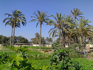
In ecology, an oasis is a fertile area of a desert or semi-desert environment that sustains plant life and provides habitat for animals. Surface water may be present, or water may only be accessible from wells or underground channels created by humans. In geography, an oasis may be a current or past rest stop on a transportation route, or less-than-verdant location that nonetheless provides access to underground water through deep wells created and maintained by humans. Although they depend on a natural condition, such as the presence of water that may be stored in reservoirs and used for irrigation, most oases, as we know them, are artificial.
The Qattara Depression is a depression in northwestern Egypt, specifically in the Matruh Governorate. The depression is part of the Western Desert of Egypt. The Qattara Depression lies below sea level, and its bottom is covered with salt pans, sand dunes, and salt marshes. The depression extends between the latitudes of 28°35' and 30°25' north and the longitudes of 26°20' and 29°02' east.
Awjila is an oasis town in the Al Wahat District in the Cyrenaica region of northeastern Libya. Since classical times it has been known as a place where high quality dates are farmed. Since the Arab conquest in the 7th century, Islam has played an important role in the community. The oasis is located on the east-west caravan route between Egypt and Tripoli, Libya, and the north-south route between Benghazi and the Sahel between Lake Chad and Darfur. In the past, it was an important trading center. The people cultivate small gardens using water from deep wells. Recently, the oil industry has become an increasingly important source of employment.

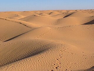
The Libyan Desert is a geographical region filling the northeastern Sahara Desert, from eastern Libya to the Western Desert of Egypt and far northwestern Sudan. On medieval maps, its use predates today's Sahara, and parts of the Libyan Desert include the Sahara's most arid and least populated regions; this is chiefly what sets the Libyan Desert apart from the greater Sahara. The consequent absence of grazing, and near absence of waterholes or wells needed to sustain camel caravans, prevented Trans-Saharan trade between Kharga close to the Nile, and Murzuk in the Libyan Fezzan. This obscurity saw the region overlooked by early European explorers, and it was not until the early 20th century and the advent of the motor car before the Libyan Desert started to be fully explored.
Patrick Andrew Clayton DSO MBE was a British surveyor and soldier. He was the basis for the character of Peter Madox in The English Patient.

László Adolf Ede György Mária Almásy de Zsadány et Törökszentmiklós was a Hungarian aristocrat, motorist, desert explorer, aviator, Scout-leader, and sportsman who served as the basis for the protagonist in both Michael Ondaatje's novel The English Patient (1992) and the movie adaptation of the same name (1996).

Gilf Kebir is a plateau in the New Valley Governorate of the remote southwest corner of Egypt, and southeast Libya. Its name translates as "the Great Barrier". This 7,770 km2 (3,000 sq mi) sandstone plateau, roughly the size of Puerto Rico, rises 300 m (980 ft) from the Libyan Desert floor. It is the true heart of the Gilf Kebir National Park.

Trans-Saharan trade is trade between sub-Saharan Africa and North Africa that requires travel across the Sahara. Though this trade began in prehistoric times, the peak of trade extended from the 8th century until the early 17th century CE. The Sahara once had a different climate and environment. In Libya and Algeria, from at least 7000 BCE, pastoralism, large settlements and pottery were present. Cattle were introduced to the Central Sahara (Ahaggar) between 4000 and 3500 BCE. Remarkable rock paintings in arid regions portray flora and fauna that are not present in the modern desert.

Friedrich Gerhard Rohlfs was a German geographer, explorer, author and adventurer.

Tuat, or Touat, is a natural region of desert in central Algeria that contains a string of small oases. In the past, the oases were important for caravans crossing the Sahara.

Mount Uwaynat or Gabal El Uweinat is a mountain range in the area of the Egyptian-Libyan-Sudanese tripoint. Because of thousands of prehistoric rock art sites, it is considered an important witness to the development of early pastoralism in the Sahara.
William Boyd Kennedy Shaw OBE was a British desert explorer, botanist, archaeologist and soldier. During the Second World War he served with the British Army's Long Range Desert Group, and the Special Air Service Regiment. He was known, variously as Bill Shaw or Bill Kennedy-Shaw, but preferred the latter form of his name, which he always used in his writings.

The Senussi campaign took place in North Africa from November 1915 to February 1917, during the First World War. The campaign was fought by the Kingdom of Italy and the British Empire against the Senussi, a religious order of Arabic nomads in Libya and Egypt. The Senussi were courted by the Ottoman Empire and the German Empire. Recognising French and Italian threats, the Ottoman Sultan, Abdul Hamid II, had twice sent his aide-de-camp Azmzade Sadik El Mueyyed to meet Sheikh Muhammed El Mehdi El Senussi to cultivate positive relations and counter the west European scramble for Africa. In the summer of 1915, the Ottomans persuaded the Grand Senussi, Ahmed Sharif as-Senussi, to declare jihad, attack British-occupied Egypt from the west and encourage insurrection in Egypt, to divert British forces.
Operation Salam was a 1942 World War II military operation organised by the Abwehr under the command of the Hungarian desert explorer László Almásy. The mission was conceived in order to assist Panzer Army Africa by delivering two German spies into British-held Egypt.
The Grand Erg Oriental is a large erg or "field of sand dunes" in the Sahara Desert. Situated for the most part in Saharan lowlands of northeast Algeria, the Grand Erg Oriental covers an area some 600 km wide by 200 km north to south. The erg's northeastern edge spills over into neighbouring Tunisia.

The Capture of Kufra was part of the Allied Western Desert Campaign during the Second World War. Kufra is a group of oases in the Kufra District of south-eastern Cyrenaica in the Libyan Desert. In 1940, it was part of the colony of Italian Libya Libia Italiana, which was part of Africa Settentrionale Italiana (ASI), which had been established in 1934. With some early assistance from the British Long Range Desert Group, Kufra was besieged from 31 January to 1 March 1941 by Free French forces which forced the surrender of the Italian and Libyan garrison.

The Cave of Swimmers is a cave with ancient rock art in the mountainous Gilf Kebir plateau of the Libyan Desert section of the Sahara. It is located in the New Valley Governorate of southwest Egypt, near the border with Libya.
Kitāb al-Kanūz, sometimes called The Book of Hidden Pearls, is a lost medieval Arabic manuscript from the 15th century. The manuscript is a hunter's guide noted for its mention of the Zerzura oasis. The author and exact dating of the manuscript are unknown.
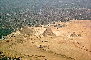
In Egypt, the Western Desert is an area of the Sahara that lies west of the river Nile, up to the Libyan border, and south from the Mediterranean Sea to the border with Sudan. It is named in contrast to the Eastern Desert which extends east from the Nile to the Red Sea. The Western Desert is mostly rocky desert, though an area of sandy desert, known as the Great Sand Sea, lies to the west against the Libyan border. The desert covers an area of 680,650 km2 (262,800 sq mi) which is two-thirds of the land area of the country. Its highest elevation is 1,000 m (3,300 ft) in the Gilf Kebir plateau to the far south-west of the country, on the Egypt-Sudan-Libya border. The Western Desert is barren and uninhabited save for a chain of oases which extend in an arc from Siwa, in the north-west, to Kharga in the south. It has been the scene of conflict in modern times, particularly during the Second World War.