Ziegenberg (Saxony-Anhalt)

Last updated
Sunrise over the Ziegenberg hill itself, seen from the Struvenberg Ziegenberg from Struvenberg.jpg
Sunrise over the Ziegenberg hill itself, seen from the Struvenberg
Crest of the Ziegenberge ridge, looking NW along the Struvenberg Ziegenberg1.png
Crest of the Ziegenberge ridge, looking NW along the Struvenberg

The Ziegenberg is a low ridge between the villages of Benzingerode and Heimburg on the northern edge of the Harz Mountains in central Germany. The ridge is a designated nature reserve. The reserve has an area of 88.4 hectares and has a variety of habitats including mesophytic grassland (Halbtrockenrasen), bushes, pine woods and wet meadows. Its highest points are the eponymous Ziegenberg (315.7 metres above NN [1] ) and the Struvenberg (291 m [1] )

Benzingerode human settlement in Germany

Benzingerode has been a village incorporated into the borough of Wernigerode since 1 April 1993. in the district of Harz in the German state of Saxony-Anhalt.

Heimburg Stadtteil of Blankenburg am Harz in Saxony-Anhalt, Germany

Heimburg is a village and a former municipality in the district of Harz, in Saxony-Anhalt, Germany. Since 1 January 2010, it is part of the town Blankenburg am Harz.

Grassland areas where the vegetation is dominated by grasses (Poaceae)

Grasslands are areas where the vegetation is dominated by grasses (Poaceae); however, sedge (Cyperaceae) and rush (Juncaceae) families can also be found along with variable proportions of legumes, like clover, and other herbs. Grasslands occur naturally on all continents except Antarctica. Grasslands are found in most ecoregions of the Earth. For example, there are five terrestrial ecoregion classifications (subdivisions) of the temperate grasslands, savannas, and shrublands biome (ecosystem), which is one of eight terrestrial ecozones of the Earth's surface.

Contents

Geology

As part of the northern uplift zone of the Harz, the Ziegenberg was formed during the Hercynian mountain building phase. As it was uplifted, the horizontal strata of the surrounding area, mainly consisting of muschelkalk, were tilted. The northern part of the Ziegenberg is characterized by silt and marl.

The Muschelkalk is a sequence of sedimentary rock strata in the geology of central and western Europe. It has a Middle Triassic age and forms the middle part of the tripartite Germanic Trias, that give the Triassic its name, lying above the older Buntsandstein and below the younger Keuper. The Muschelkalk consists of a sequence of limestone and dolostone beds.

Silt is granular material of a size between sand and clay, whose mineral origin is quartz and feldspar. Silt may occur as a soil or as sediment mixed in suspension with water and soil in a body of water such as a river. It may also exist as soil deposited at the bottom of a water body, like mudflows from landslides. Silt has a moderate specific area with a typically non-sticky, plastic feel. Silt usually has a floury feel when dry, and a slippery feel when wet. Silt can be visually observed with a hand lens, exhibiting a sparkly appearance. It also can be felt by the tongue as granular when placed on the front teeth.

Marl Lime-rich mud or mudstone which contains variable amounts of clays and silt

Marl or marlstone is a calcium carbonate or lime-rich mud or mudstone which contains variable amounts of clays and silt. The dominant carbonate mineral in most marls is calcite, but other carbonate minerals such as aragonite, dolomite, and siderite may be present. Marl was originally an old term loosely applied to a variety of materials, most of which occur as loose, earthy deposits consisting chiefly of an intimate mixture of clay and calcium carbonate, formed under freshwater conditions; specifically an earthy substance containing 35–65% clay and 65–35% carbonate. It also describes a habit of coralline red alga. The term is today often used to describe indurated marine deposits and lacustrine (lake) sediments which more accurately should be named 'marlstone'. Marlstone is an indurated rock of about the same composition as marl, more correctly called an earthy or impure argillaceous limestone. It has a blocky subconchoidal fracture, and is less fissile than shale. The term 'marl' is widely used in English-language geology, while the terms Mergel and Seekreide are used in European references.

Flora

Within the nature reserve are the northernmost communities of Lotharingian or French Flax (Linum leonii).

Amongst the other plants that occur here are the Burnet Saxifrage (Pimpinella saxifraga), Large Self-heal (Prunella grandiflora), Fringed Gentian (Gentianopsis ciliata), Sickle hare's ear (Bupleurum falcatum) and Stemless carline thistle (Carlina acaulis).

Land use and nature reserve

Southern slopes of the Struvenberg Struvenberg - Naturschutzgebiet Ziegenberg.jpg
Southern slopes of the Struvenberg

Just before the hill drops away towards Benzingerode, the remains of fortifications belonging to a 10th-century fortress, the Struveburg are visible in the terrain. After the woods had been cleared, the hill ridge was used for centuries as grazing land. Later parts of the area were reforested with Black Pine (Pinus nigra) and quarries established.

The aim of the reserve, created on 1 January 1982, [2] is "the protection and conservation of arid and semi-arid grassland with their sub-Mediterranean plant communities and diverse insect fauna" [3] and the conservation of geological features. To this end, the hill is occasionally grazed by sheep and scrub is cleared away. The pine forest of the southern slope is to be turned into an area of forest steppe with sessile oak. Other areas will be left to develop perfectly naturally.

Sheep Domesticated ruminant bred for meat, wool and milk

Domestic sheep are quadrupedal, ruminant mammals typically kept as livestock. Like most ruminants, sheep are members of the order Artiodactyla, the even-toed ungulates. Although the name sheep applies to many species in the genus Ovis, in everyday usage it almost always refers to Ovis aries. Numbering a little over one billion, domestic sheep are also the most numerous species of sheep. An adult female sheep is referred to as a ewe, an intact male as a ram or occasionally a tup, a castrated male as a wether, and a younger sheep as a lamb.

Forest steppe vegetation zone

A forest steppe is a temperate-climate ecotone and habitat type composed of grassland interspersed with areas of woodland or forest.

The crest of the ridge is partly accessible on two parallel paths. Along the foot of the southern slope runs a dirt track.

Related Research Articles

Barnack Hills & Holes National Nature Reserve

Barnack Hills & Holes is a 23.3 hectare biological Site of Special Scientific Interest in Barnack in Cambridgeshire. It is also a national nature reserve. It is a Nature Conservation Review site, Grade I. In 2002 it was designated as a Special Area of Conservation, to protect the orchid rich grassland as part of the Natura 2000 network of sites throughout the European Union.

The Finne is a ridge of hills in the German states of Saxony-Anhalt and Thuringia up to 370.1 m above sea level (NHN) and 23 km long.

Stapenberg mountain in Germany

The Stapenberg is a 443 metre high hill spur in the Harz Mountains of central Germany in Harz district in the federal state of Saxony-Anhalt.

The Burgberg is a ridge of hills up to 345.2 m above sea level (NN) high in the German federal state of Lower Saxony.

Kapf (Egenhausen)

The Egenhäuser Kapf rises in the northern Black Forest, roughly halfway between Freudenstadt and Calw and, at 635 m above NN, it is the highest point along the Bömbach valley. As the crow flies it is around 8 kilometres (north)west of Nagold and about 3 kilometres southeast of Altensteig, between the municipalities of Egenhausen and Walddorf.

Heimburg Castle castle ruin in Blankenburg, Saxony-Anhalt, Germany

Heimburg Castle, also called the Altenburg or Alteburg, is a ruined castle on an oval hilltop about 330 metres above sea level (NN) which is located just north of the Harz Mountains in central Germany. The ruins of this hilltop castle stand above the village of Heimburg in the borough of Blankenburg in the district of Harz in the state of Saxony-Anhalt. It is checkpoint no. 84 in the Harzer Wandernadel hiking network.

Großer Fallstein wooded hill region in Germany

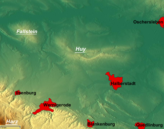
The Großer Fallstein is a wooded hill region in the German state of Saxony-Anhalt. It lies in the district of Harz on the territory of the town of Osterwieck, north of the Harz Mountains. Its highest point has an elevation of 288 metres above sea level (NN).

Struvenburg

The Struvenburg was a medieval castle immediately east of Benzingerode, a village in the borough of Wernigerode in the district of Harz in the German state of Saxony-Anhalt. Today only a few earthworks remain. Very little is known about this castle. The name may be derived from the adjective struf = scrubby or rough.

Daneway Banks SSSI

Daneway Banks is a 17-hectare (42-acre) biological Site of Special Scientific Interest in Gloucestershire, notified in 1954 and renotified in 1983. It lies half a mile west of Sapperton and is part of a group of wildlife sites in the Frome Valley that includes Siccaridge Wood and Sapperton Canal reserves. The site is in the Cotswold Area of Outstanding Natural Beauty.

Austberg mountain in the Harz, Germany

The Austberg, also called the Augsberg or Augstberg, is a low hill, 292 m above sea level (NN), in the northern Harz Foreland near the village of Benzingerode in the district of Harz in the German state of Saxony-Anhalt.

Ackeburg castle

The Ackeburg, also called the Ackenburg, in the Harz Mountains of central Germany, is the site of a high medieval hill castle, 333.2 m above sea level (NN), in the borough of Falkenstein/Harz in Harz district in the state of Saxony-Anhalt. It was first mentioned in 1216 and was abandoned or destroyed in 1400. There was also a village associated with it, known as Akkeburg.

Harz/Saxony-Anhalt Nature Park nature park in Saxony-Anhalt, Germany

The Harz/Saxony-Anhalt Nature Park is situated n the districts of Harz and Mansfeld-Südharz in the German state of Saxony-Anhalt. The nature park which lies in the Harz Mountains was founded in 2003 and has an area of around 1,660 km². It is looked after by the Harz Regional Association.

Kapitelsberg mountain in Germany

The Kapitelsberg in the Harz Mountains of Germany is a hill, 535.7 m above sea level (NN), near the village of Tanne in the county of Harz, Saxony-Anhalt.

Ölbergshöhe mountain in the Harz, Germany

The Ölbergshöhe in the Harz Mountains of central Germany is a mountain spur, 320.6 m, of the Ramberg ridge near Bad Suderode in the Saxony-Anhalt county of Harz.

South Harz Nature Park nature park in Thuringia, Germany

The South Harz Nature Park is located in the county of Nordhausen in north Thuringia, Germany. The act designating this nature park in the Harz Mountains came into force on 31 December 2010 and thus founded the fifth nature park in Thuringia. It has an area of 267 km². The park is managed by the South Harz Tourist Association in conjunction with the Kyffhäuser Nature Park.

Sandlünz mountain in Germany

The Sandlünz is a hill in the Harz Mountains of Germany. It is 516.2 m above sea level (NN) and located near Netzkater in the county of Nordhausen in the state of Thuringia.

The South Harz Karst Landscape Biosphere Reserve is a biosphere reserve in the German state of Saxony-Anhalt. It was founded on 23 March 2009 and is thus the 16th biosphere reserve in Germany. Its recognition by UNESCO is pending.

Brush Hill Local Nature Reserve

Brush Hill is a 14.7 hectare Local Nature Reserve east of Princes Risborough in Buckinghamshire. It has been managed since 2013 by the Chiltern Society, and it is part of the Chilterns Area of Outstanding Natural Beauty.

References

  1. 1 2 Map services of the Federal Agency for Nature Conservation
  2. Erklärung von zwei Landschaftsteilen zu Naturschutzgebieten und zur Erweiterung von zwei bestehenden Naturschutzgebieten, 3. Tagung des Bezirkstages Magdeburg vom 10 December 1981, Beschluß Nr. 22-3 (VIII)/81 (pdf file, 12 kb)
  3. Landesverwaltungsamt Sachsen-Anhalt: Ziegenberg bei Heimburg.

Coordinates: 51°49.73′N10°53.32′E / 51.82883°N 10.88867°E / 51.82883; 10.88867