The Nile is a major north-flowing river in northeastern Africa. The longest river in Africa, it has historically been considered the longest river in the world, though this has been contested by research suggesting that the Amazon River is slightly longer, the Nile is amongst the smallest of the major world rivers by measure of cubic metres flowing annually. About 6,650 km (4,130 mi) long, its drainage basin covers eleven countries: Tanzania, Uganda, Rwanda, Burundi, the Democratic Republic of the Congo, Kenya, Ethiopia, Eritrea, South Sudan, Republic of the Sudan, and Egypt. In particular, the Nile is the primary water source of Egypt and Sudan.

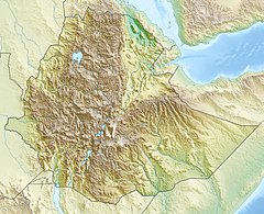
Ethiopia is located in the Horn of Africa. It is bordered by Eritrea to the north, Djibouti and Somalia to the east, Sudan and South Sudan to the west, and Kenya to the south. Ethiopia has a high central plateau that varies from 1,290 to 3,000 m above sea level, with the highest mountain reaching 4,533 m (14,872 ft).

The Blue Nile is a river originating at Lake Tana in Ethiopia. It travels for approximately 1,450 km (900 mi) through Ethiopia and Sudan. Along with the White Nile, it is one of the two major tributaries of the Nile, and supplies about 80% of the water in the Nile during the rainy season.

Ethiopia, officially the Federal Democratic Republic of Ethiopia, is a landlocked country in the Horn of Africa. It shares borders with Eritrea to the north, Djibouti and Somalia (Somaliland) to the northeast, Somalia to the east, Kenya to the south, South Sudan to the west and Sudan to the northwest. Ethiopia has a total area of 1,100,000 square kilometres (420,000 sq mi) and over 117 million inhabitants and is the 12th-most populous country in the world and the 2nd-most populous in Africa. The national capital and largest city, Addis Ababa, lies several kilometres west of the East African Rift that splits the country into the African and Somali tectonic plates.

The Second Italo-Ethiopian War, also referred to as the Second Italo-Abyssinian War, was a war of aggression which was fought between Italy and Ethiopia from October 1935 to February 1937. In Ethiopia it is often referred to simply as the Italian Invasion, and in Italy as the Ethiopian War. It is seen as an example of the expansionist policy that characterized the Axis powers and the ineffectiveness of the League of Nations before the outbreak of the Second World War.
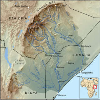
The Shebelle River begins in the highlands of Ethiopia, and then flows southeast into Somalia towards Mogadishu. Near Mogadishu, it turns sharply southwest, where it follows the coast. Below Mogadishu, the river becomes seasonal. During most years, the river dries up near the mouth of the Jubba River, while in seasons of heavy rainfall, the river actually reaches the Jubba and thus the Somali Sea.
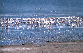
The Rift Valley lakes are a series of lakes in the East African Rift valley that runs through eastern Africa from Ethiopia in the north to Malawi in the south, and includes the African Great Lakes in the south. These include some of the world's oldest lakes, deepest lakes, largest lakes by area, and largest lakes by volume. Many are freshwater ecoregions of great biodiversity, while others are alkaline "soda lakes" supporting highly specialised organisms.

Dire Dawa is a city in eastern Ethiopia near the Somali border and one of two chartered cities in Ethiopia. It is divided administratively into two woredas, the city proper and the non-urban woreda of Gurgura.

The Tekezé or Täkkäze River, also spelled Takkaze, is a major river of Ethiopia. For part of its course it forms a section of the westernmost border of Ethiopia and Eritrea. The river is also known as the Setit in Eritrea, western Ethiopia, and eastern Sudan. According to materials published by the Ethiopian Central Statistical Agency, the Tekezé River is 608 kilometers (378 mi) long. The canyon which it has created is the deepest in Africa and one of the deepest in the world, at some points having a depth of over 2000 meters.

The Awash is a major river of Ethiopia. Its course is entirely contained within the boundaries of Ethiopia and empties into a chain of interconnected lakes that begin with Lake Gargori and end with Lake Abbe on the border with Djibouti, some 100 kilometres from the head of the Gulf of Tadjoura. It is the principal stream of an endorheic drainage basin covering parts of the Amhara, Oromia and Somali Regions, as well as the southern half of the Afar Region. According to Huntingford, in the 16th century the Awash river was called the great Dir river and lay in the country of the Muslims.

The Mareb River, or Gash River is a river flowing out of central Eritrea. Its chief importance is defining part of the boundary between Eritrea and Ethiopia, between the point where the Mai Ambassa enters the river at 14°53.6′N37°54.8′E to the confluence of the Balasa with the Mareb at 14°38′N39°1.3′E.

The Omo River in southern Ethiopia is the largest Ethiopian river outside the Nile Basin. Its course is entirely contained within the boundaries of Ethiopia, and it empties into Lake Turkana on the border with Kenya. The river is the principal stream of an endorheic drainage basin, the Turkana Basin.

The Baro River is a river in southwestern Ethiopia, which defines part of Ethiopia's border with South Sudan. From its source in the Ethiopian Highlands it flows west for 306 kilometres (190 mi) to join the Pibor River. The Baro-Pibor confluence marks the beginning of the Sobat River, a tributary of the White Nile.

Dogu'a Tembien is one of the woredas in the Tigray Region of Ethiopia. It is named in part after the former province of Tembien. Nowadays, the mountainous district is part of the Southeastern Tigray Zone. The administrative centre of this woreda is Hagere Selam.
The Akobo River is a river on the border between South Sudan and Ethiopia. From its source in the Ethiopian Highlands near Mizan Teferi it flows west for 434 kilometres (270 mi) to join the Pibor River. The Pibor flows into the Sobat River, which in turn empties into the White Nile.
Energy in Ethiopia is energy and electricity production, consumption, transport, exportation, and importation in Ethiopia.
Ethiopia is called the water tower of Africa due to its combination of mountainous areas with a comparatively large share of water resources in Africa. Only a fraction of this potential has been harnessed so far, 1% at the beginning of the 21st century. In order to become the powerhouse of Africa, Ethiopia is actively exploiting its water resources by building dams, reservoirs, irrigation and diversion canals and hydropower stations. The benefits of the dams are not only limited to hydropower. Many dams are multi-purpose dams that are also designed to provide water for irrigation, drinking water and flood control. However, hydropower is expected to be the main benefit of the dams.

The Grand Ethiopian Renaissance Dam, formerly known as the Millennium Dam and sometimes referred to as Hidase Dam, is a gravity dam on the Blue Nile River in Ethiopia under construction since 2011. The dam is in the Benishangul-Gumuz Region of Ethiopia, about 45 km (28 mi) east of the border with Sudan.

Ethiopia generates most of its electricity from renewable energy, mainly hydropower