
The Beočin monastery is a Serbian Orthodox monastery, located just outside Beočin, on Fruška Gora mountain in the northern Serbian province of Vojvodina.

The Privina Glava Monastery is a Serb Orthodox monastery on the Fruška Gora mountain in northern Serbia, in the province of Vojvodina. According to legend, Privina Glava was founded by a feudal lord whose name was Priba/Priva, in the 12th century while another attribution is the 15th century Srem despots of the Branković family. The earliest historical records about the monastery are dated in 1566/1567. The icons in the altar screen were painted by Andrej Šaltist in 1786, and the wall paintings by Kuzman Kolarić in 1791.

The Petkovica Monastery is a Serbian Orthodox monastery located on Mount Fruška Gora, in the province of Vojvodina, northern Serbia. According to tradition, it was founded by the widow of Stefan Štiljanović, Despotess Jelena. The earliest historical records mentioning the monastery are dated to 1566/1567.
Lumeje is a municipality in Moxico Province, Angola. The seat of the municipality is Cameia. It is notable for its national park. Lumeje and Lucano form the boundaries of the park. Cameia National Park was established as a game reserve in 1938 and proclaimed a national park in 1957. The municipality is home to two lakes, Lago Cameia and Lago Dilolo, the latter of which is the largest lake in Angola.

Jugla is a neighbourhood of Riga, the capital of Latvia. It is located west of the Lake Jugla and southeast of the Lake Ķīšezers. Jugla is bordered by Čiekurkalns, Mežciems and Teika to the west, Dreiliņi to the southwest, Brekši to the southeast and Bukulti to the east.
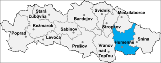
Sopkovce is a village and municipality in Humenné District in the Prešov Region of north-east Slovakia.
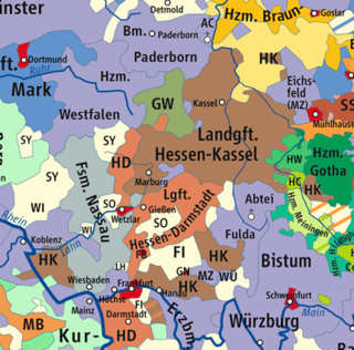
The Landgraviate of Hesse-Darmstadt was a State of the Holy Roman Empire, ruled by a younger branch of the House of Hesse. It was formed in 1567 following the division of the Landgraviate of Hesse between the four sons of Landgrave Philip I.

Kii Station is a railway station in Wakayama, Wakayama Prefecture, Japan.

Białotarsk is a village in the administrative district of Gmina Gostynin, within Gostynin County, Masovian Voivodeship, in east-central Poland. It lies approximately 11 kilometres (7 mi) west of Gostynin and 118 km (73 mi) west of Warsaw.
Stefanów is a village in the administrative district of Gmina Gostynin, within Gostynin County, Masovian Voivodeship, in east-central Poland. It lies approximately 7 kilometres (4 mi) north-east of Gostynin and 102 km (63 mi) west of Warsaw.
Strzałki is a village in the administrative district of Gmina Gostynin, within Gostynin County, Masovian Voivodeship, in east-central Poland. It lies approximately 3 kilometres (2 mi) west of Gostynin and 109 km (68 mi) west of Warsaw.
Stramniczka is a village in the administrative district of Gmina Dygowo, within Kołobrzeg County, West Pomeranian Voivodeship, in north-western Poland.
Afşar Dam is a dam in Manisa Province, Turkey, built between 1973 and 1977. The dam creates a lake which is 5.25 km ² and irrigates 13,500 hectares.
Buldan Dam is a dam in Denizli Province, Turkey. It was built between 1962 and 1967.

Memorial Hall in Albert Square, Manchester, England, was constructed in 1863–1866 by Thomas Worthington. It was built to commemorate the bicentennial anniversary of the 1662 Act of Uniformity, when the secession of some 2,000 Anglican clergy led to the birth of Nonconformism It is a Grade II* listed building as of 14 February 1972.

Gornji Rogatec is a small village in the Municipality of Grosuplje in central Slovenia. The area is part of the historical region of Lower Carniola. The municipality is now included in the Central Slovenia Statistical Region.
Kosmos 2461 is one of a set of three Russian military satellites launched in 2010 as part of the GLONASS satellite navigation system. It was launched with Kosmos 2459 and Kosmos 2460
Marijan is a village in Behrestagh Rural District, in the Central District of Amol County, Mazandaran Province, Iran. At the 2006 census, its population was 28, in 7 families.

Kafir, Idlib is a Syrian village located in Jisr al-Shughur Nahiyah in Jisr al-Shughur District, Idlib. According to the Syria Central Bureau of Statistics (CBS), Kafir, Idlib had a population of 1567 in the 2004 census.
The Estadio Olímpico Universitario de Colima is a multi-use stadium in Colima City, Colima, Mexico. It is currently used mostly for football matches and is the home stadium for Loros de la Universidad de Colima. The stadium has a capacity of 11,812 people and opened in 1994.


