Zurqes

Last updated

Coordinates: 40°32′N46°15′E / 40.533°N 46.250°E / 40.533; 46.250

Geographic coordinate system Coordinate system

A geographic coordinate system is a coordinate system that enables every location on Earth to be specified by a set of numbers, letters or symbols. The coordinates are often chosen such that one of the numbers represents a vertical position and two or three of the numbers represent a horizontal position; alternatively, a geographic position may be expressed in a combined three-dimensional Cartesian vector. A common choice of coordinates is latitude, longitude and elevation. To specify a location on a plane requires a map projection.

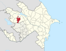
Zurqes
Azerbaijan adm location map.svg
Red pog.svg
Zurqes
Coordinates: 40°32′N46°15′E / 40.533°N 46.250°E / 40.533; 46.250
CountryFlag of Azerbaijan.svg  Azerbaijan
Rayon Goygol
Time zone UTC+4 (AZT)
  Summer (DST) UTC+5 (AZT)

Zurqes (also, Aşağı Çiçəkli and Zurges) is a village in the Goygol Rayon of Azerbaijan.

Azerbaijan Republic in Western Asia and Eastern Europe

Azerbaijan, officially the Republic of Azerbaijan, is a country in the South Caucasus region of Eurasia at the crossroads of Eastern Europe and Western Asia. It is bounded by the Caspian Sea to the east, Russia to the north, Georgia to the northwest, Armenia to the west and Iran to the south. The exclave of Nakhchivan is bounded by Armenia to the north and east, Iran to the south and west, and has an 11 km long border with Turkey in the northwest.

Related Research Articles

Arctic Archipelago Canadian archipelago

The Arctic Archipelago, also known as the Canadian Arctic Archipelago, is a group of islands north of the Canadian mainland.

Kecel Town in Bács-Kiskun, Hungary

Kecel is a town in Bács-Kiskun county, in southern Hungary.

Elek Town in Békés, Hungary

For people with the given name, see Elek.For people with the surname, see Elek (surname).

Șuici Commune in Argeș County, Romania

Șuici is a commune in the northern Argeș County, Muntenia, Romania. It is composed of six villages: Ianculești, Paltenu, Păuleni, Rudeni, Șuici and Valea Calului.

Yerek-Mankunk Place in Tartar, Azerbaijan

Yerek-Mankunk is a village in the Tartar Rayon of Azerbaijan.

Ślężany Village in Masovian, Poland

Ślężany is a village in the administrative district of Gmina Dąbrówka, within Wołomin County, Masovian Voivodeship, in east-central Poland. It lies approximately 21 km (13 mi) north of Wołomin and 40 km (25 mi) north-east of Warsaw.

Aşağı Zurnabad is a village in the municipality of Zurnabad in the Goygol Rayon of Azerbaijan.

Yuxarı Fərəcan is a village in the Lachin Rayon of Azerbaijan.

Aşağı Cicimli is a village in the Lachin Rayon of Azerbaijan.

Csöde is a village in Zala County, Hungary.

Magyarszentmiklós is a village in Zala County, Hungary.

Oltárc is a village in Zala County, Hungary.

Tormafölde is a village in Zala County, Hungary.

Ninase is a village in Saaremaa Parish, Saare County in western Estonia.

Sogra is the name of several rural localities in Russia:

Krasnaya Zarya is the name of several rural localities in Russia.

Bilyayivka Raion Raion in Odessa Oblast, Ukraine

Bilyayivka Raion is a raion (district) in Odessa Oblast of Ukraine. Its administrative center is the town of Bilyayivka. Population: 80 335.

German submarine U-828 was a Type VIIC/41 U-boat of Nazi Germany's Kriegsmarine during the Second World War. She saw no combat and was scuttled at the end of the war.

Aşağı Daşkəsən is a village in the municipality of Daşkəsən qəsəbə in the Dashkasan Rayon of Azerbaijan.

References

The GEOnet Names Server (GNS) provides access to the National Geospatial-Intelligence Agency's (NGA) and the U.S. Board on Geographic Names's (BGN) database of geographic feature names and locations for locations outside the United States. The database is the official repository of foreign place-name decisions approved by the US BGN. Approximately 20,000 of the database's features are updated monthly. The database never removes an entry, "except in cases of obvious duplication".