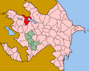
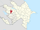
Coordinates: 40°29′N46°22′E / 40.483°N 46.367°E
A geographic coordinate system is a coordinate system that enables every location on Earth to be specified by a set of numbers, letters or symbols. The coordinates are often chosen such that one of the numbers represents a vertical position and two or three of the numbers represent a horizontal position; alternatively, a geographic position may be expressed in a combined three-dimensional Cartesian vector. A common choice of coordinates is latitude, longitude and elevation. To specify a location on a plane requires a map projection.
Kalinino | |
---|---|
Coordinates: 40°29′N46°22′E / 40.483°N 46.367°E | |
Country | |
Rayon | Goygol |
Time zone | AZT (UTC+4) |
• Summer (DST) | AZT (UTC+5) |
Kalinino is a village in the Goygol Rayon of Azerbaijan. It is named after Mikhail Kalinin, a Soviet revolutionary and a member of the Politburo of the Communist Party of the Soviet Union.
Azerbaijan, officially the Republic of Azerbaijan, is a country in the South Caucasus region of Eurasia at the crossroads of Eastern Europe and Western Asia. It is bounded by the Caspian Sea to the east, Russia to the north, Georgia to the northwest, Armenia to the west and Iran to the south. The exclave of Nakhchivan is bounded by Armenia to the north and east, Iran to the south and west, and has an 11 km long border with Turkey in the northwest.
Mikhail Ivanovich Kalinin, known familiarly by Soviet citizens as "Kalinych", was a Bolshevik revolutionary and a Soviet politician. He served as head of state of the Russian Soviet Federative Socialist Republic and later of the Soviet Union from 1919 to 1946. From 1926, he was a member of the Politburo of the Communist Party of the Soviet Union. The former East-Prussian city of Königsberg was renamed Kaliningrad after Kalinin. The city of Tver was also known as Kalinin until the end of the Soviet Union in 1990.
The Soviet Union, officially the Union of Soviet Socialist Republics (USSR), was a socialist state in Eurasia that existed from 1922 to 1991. Nominally a union of multiple national Soviet republics, its government and economy were highly centralized. The country was a one-party state, governed by the Communist Party with Moscow as its capital in its largest republic, the Russian Soviet Federative Socialist Republic. Other major urban centres were Leningrad, Kiev, Minsk, Alma-Ata, and Novosibirsk. It spanned over 10,000 kilometres east to west across 11 time zones, and over 7,200 kilometres north to south. It had five climate zones: tundra, taiga, steppes, desert and mountains.
Samukh is a rayon of Azerbaijan. The administrative centre, also Samux, was formerly called Nəbiağalı and before that Safaraliyev.
Bonyhádvarasd is a village in Tolna County, Hungary.
Bahnea is a commune in Mureș County, Romania. It is composed of seven villages: Bahnea, Bernadea (Bernád), Cund, Daia (Dányán), Gogan (Gógán), Idiciu (Jövedics) and Lepindea (Leppend).
Xatman is a village in the Agsu Rayon of Azerbaijan. The village forms part of the municipality of Dilman.
Aşağı Ağcakənd is a village in the Goranboy Rayon of Azerbaijan. The municipality consists of the villages of Aşağı Ağcakənd, Yuxarı Ağcakənd and Meşəli.
Erkeç is a village in the Goranboy Rayon of Azerbaijan. The village forms part of the municipality of Mənəşli.
Qarasuçu is a village in the Goranboy Rayon of Azerbaijan. The village forms part of the municipality of Hazırəhmədli.
Babadin is a village in the Lachin Rayon of Azerbaijan.
Keşqutan is a village in the Qakh Rayon of Azerbaijan. The village forms part of the municipality of Xələftala.
Martakert or Aghdara is a town that is de facto in the Republic of Artsakh, a state with limited recognition established in the former Nagorno-Karabakh Autonomous Oblast of the Azerbaijan SSR. The town is internationally recognized as being de jure in Azerbaijan. The area around the town has been controlled by Artsakh forces since the end of the 1991–94 Nagorno-Karabakh War.
Qədiməlikqışlaq is a village in the Khachmaz Rayon of Azerbaijan. The village forms part of the municipality of Qaracik Zeyid.
Kamo is a former village in the Goygol Rayon of Azerbaijan. The ethnic Armenians that populated the village and the neighbouring village of Azad left in the course of the Nagorno-Karabakh War. In 1989, both villages became home to ethnic Azeri refugees from Zod, Armenia. Azad became the new municipal seat known as Yeni Zod. Kamo was incorporated into Yeni Zod and lost its status as a village in 1999.
Hacımahmudlu is a village in the Yevlakh Rayon of Azerbaijan. The village forms part of the municipality of Qaramanlı.
Yegakor is a village in the Tartar Rayon of Azerbaijan.
Dəyirmanlar is a village and municipality in the Goranboy Rayon of Azerbaijan. It has a population of 897. The municipality consists of the villages of Dəyirmanlar and Azad.
Məlikzadə is a village in the municipality of Hənifə in the Balakan Rayon of Azerbaijan.
Mollalar is a village in the Barda Rayon of Azerbaijan.
Xallava is a village in the Qubadli Rayon of Azerbaijan.
Qundanlı is a village in the Qubadli Rayon of Azerbaijan.
Səməd Vurğun is a village and municipality in the Shamkir Rayon of Azerbaijan. It has a population of 1,433. The village was named after Soviet writer Samad Vurgun.
This Goygol Rayon location article is a stub. You can help Wikipedia by expanding it. |