Eulate is a town and municipality located in the province and autonomous community of Navarre, northern Spain.

France Miniature is a miniature park tourist attraction in Élancourt, France featuring scale models of major French landmarks and monuments in an outdoor park.

Albanopolis was a city in ancient Roman Macedon specifically in Epirus Nova, the city of the Albanoi, an Illyrian tribe. The editors of the Barrington Atlas of the Greek and Roman World locate Albanopolis at the modern-day village of Zgërdhesh, near Krujë, Albania. The ancient city may correspond with later mentions of the settlement called Arbanon and Albanon during the Middle Ages, although it is not certain this was the same place. The city appears at 150 AD almost 300 years after Roman conquest of the region.
Khüder is a sum (district) of Selenge Province in northern Mongolia.

Məlikəhmədli is a village in the Qubadli Rayon of Azerbaijan.

Qeybalı is a village in the Khojali Rayon of Azerbaijan.

Kąty is a village in the administrative district of Gmina Biecz, within Gorlice County, Lesser Poland Voivodeship, in southern Poland. It lies approximately 9 kilometres (6 mi) north-west of Biecz, 15 km (9 mi) north of Gorlice, and 94 km (58 mi) east of the regional capital Kraków.

Nowy Garbów is a village in the administrative district of Gmina Dwikozy, within Sandomierz County, Świętokrzyskie Voivodeship, in south-central Poland. It lies approximately 6 kilometres (4 mi) north of Dwikozy, 11 km (7 mi) north of Sandomierz, and 82 km (51 mi) east of the regional capital Kielce.
Bytkowo is a village in the administrative district of Gmina Rokietnica, within Poznań County, Greater Poland Voivodeship, in west-central Poland.

Wólka Ołudzka is a village in the administrative district of Gmina Szczekociny, within Zawiercie County, Silesian Voivodeship, in southern Poland. It lies approximately 9 kilometres (6 mi) south-west of Szczekociny, 27 km (17 mi) east of Zawiercie, and 66 km (41 mi) north-east of the regional capital Katowice.
Drągowina is a village in the administrative district of Gmina Nowogród Bobrzański, within Zielona Góra County, Lubusz Voivodeship, in western Poland.

Mała Klonia is a settlement in the administrative district of Gmina Czersk, within Chojnice County, Pomeranian Voivodeship, in northern Poland. It lies approximately 18 kilometres (11 mi) west of Czersk, 14 km (9 mi) north-east of Chojnice, and 90 km (56 mi) south-west of the regional capital Gdańsk.
Małe Wędoły is a settlement in the administrative district of Gmina Czersk, within Chojnice County, Pomeranian Voivodeship, in northern Poland.

Lemany is a village in the administrative district of Gmina Sierakowice, within Kartuzy County, Pomeranian Voivodeship, in northern Poland. It lies approximately 9 kilometres (6 mi) south-west of Sierakowice, 28 km (17 mi) west of Kartuzy, and 57 km (35 mi) west of the regional capital Gdańsk.

Prusim is a settlement in the administrative district of Gmina Resko, within Łobez County, West Pomeranian Voivodeship, in north-western Poland. It lies approximately 4 kilometres (2 mi) south-east of Resko, 21 km (13 mi) north-west of Łobez, and 69 km (43 mi) north-east of the regional capital Szczecin.
Thiruverumbur is a state assembly constituency in Tiruchirappalli district in Tamil Nadu.

McAlister is a small unincorporated community in Quay County, New Mexico, United States. It is located on New Mexico State Highway 252 east of House.
The Kuala Kangsar railway station is a Malaysian train station located at the north-western side of and named after the town of Kuala Kangsar, Perak. Owned by Keretapi Tanah Melayu, it provides KTM ETS services.
Saint-Nicolas-Saint-Romain is a former railway station in Saint-Nicolas-de-la-Balerme, Nouvelle-Aquitaine, France. The station is located on the Bordeaux–Sète railway. The station was served by TER (local) services operated by SNCF. It was closed for passenger traffic in 2011.

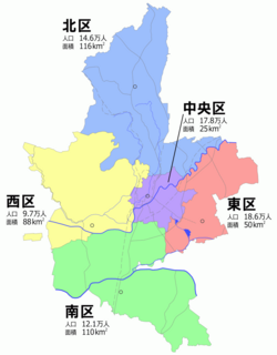
Nishi-ku (西区) is one of the five wards of Kumamoto City, Japan. Meaning literally "west ward," it is bordered by the Kita-ku, Chūō-ku, Minami-ku and also by the city of Tamana and the town of Gyokutō. As of 2012, it has a population of 93,394 people and an area of 88.21 km2.


