
Bliż is a village in the administrative district of Gmina Kąty Wrocławskie, within Wrocław County, Lower Silesian Voivodeship, in south-western Poland. Prior to 1945 it was in Germany.
Cesarzowice is a village in the administrative district of Gmina Kąty Wrocławskie, within Wrocław County, Lower Silesian Voivodeship, in south-western Poland. Prior to 1945 it was in Germany.
Gądów is a village in the administrative district of Gmina Kąty Wrocławskie, within Wrocław County, Lower Silesian Voivodeship, in south-western Poland. Prior to 1945 it was in Germany.
Gniechowice is a village in the administrative district of Gmina Kąty Wrocławskie, within Wrocław County, Lower Silesian Voivodeship, in south-western Poland. Prior to 1945 it was in Germany.
Kilianów is a village in the administrative district of Gmina Kąty Wrocławskie, within Wrocław County, Lower Silesian Voivodeship, in south-western Poland. Prior to 1945 it was in Germany.
Małkowice is a village in the administrative district of Gmina Kąty Wrocławskie, within Wrocław County, Lower Silesian Voivodeship, in south-western Poland. Prior to 1945 it was in Germany. It lies approximately 7 kilometres (4 mi) north-east of Kąty Wrocławskie and 17 km (11 mi) west of the regional capital Wrocław.
Nowa Wieś Wrocławska is a village in the administrative district of Gmina Kąty Wrocławskie, within Wrocław County, Lower Silesian Voivodeship, in south-western Poland. Prior to 1945 it was in Germany. It lies approximately 11 kilometres (7 mi) east of Kąty Wrocławskie and 13 km (8 mi) south-west of the regional capital Wrocław.
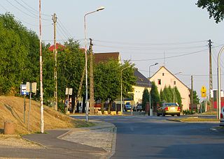
Pietrzykowice is a village in the administrative district of Gmina Kąty Wrocławskie, within Wrocław County, Lower Silesian Voivodeship, in south-western Poland. Prior to 1945 Silesia was part of Germany. As a result of the post war border changes at the end of World War 2 most of Silesia became part of Poland. When Silesia was part of Germany, Pietrzykowice was known as Petersweiler, and Wroclaw was known as Breslau. Pietrzykowice is located approximately 15km south west of Wroclaw. A sugar factory was once located in Pietrzykowice. However this factory has since been demolished. The factory processed sugar beet which was grown on farms in area around Pietrzykowice. During World War 2 the sugar factory was a POW work camp or Arbeitskommando for allied prisoners of war. Its reference number was E303. The village of Pietrzykowice has a population of 512.
Sadków is a village in the administrative district of Gmina Kąty Wrocławskie, within Wrocław County, Lower Silesian Voivodeship, in south-western Poland. Prior to 1945 it was in Germany. It lies approximately 5 kilometres (3 mi) north-east of Kąty Wrocławskie and 17 km (11 mi) south-west of the regional capital Wrocław.
Samotwór is a village in the administrative district of Gmina Kąty Wrocławskie, within Wrocław County, Lower Silesian Voivodeship, in south-western Poland. Prior to 1945 it was in Germany. It lies approximately 9 kilometres (6 mi) north-east of Kąty Wrocławskie and 15 km (9 mi) west of the regional capital Wrocław.
Stary Dwór is a village in the administrative district of Gmina Kąty Wrocławskie, within Wrocław County, Lower Silesian Voivodeship, in south-western Poland. Prior to 1945 it was in Germany.
Zabrodzie is a village in the administrative district of Gmina Kąty Wrocławskie, within Wrocław County, Lower Silesian Voivodeship, in south-western Poland. Prior to 1945 it was in Germany. It lies approximately 13 kilometres (8 mi) east of Kąty Wrocławskie and 11 km (7 mi) south-west of the regional capital Wrocław.

Bielany Wrocławskie is a village in the administrative district of Gmina Kobierzyce, within Wrocław County, Lower Silesian Voivodeship, in south-western Poland. Prior to 1945 it was in Germany.
Biskupice Podgórne is a village in the administrative district of Gmina Kobierzyce, within Wrocław County, Lower Silesian Voivodeship, in south-western Poland. Prior to 1945 it was in Germany.
Wólki is a village in the administrative district of Gmina Wartkowice, within Poddębice County, Łódź Voivodeship, in central Poland. It lies approximately 6 kilometres (4 mi) west of Wartkowice, 11 km (7 mi) north of Poddębice, and 44 km (27 mi) north-west of the regional capital Łódź.
Dąbrowa is a village in the administrative district of Gmina Miejska Górka, within Rawicz County, Greater Poland Voivodeship, in west-central Poland.
Płoty is a village in the administrative district of Gmina Czerwieńsk, within Zielona Góra County, Lubusz Voivodeship, in western Poland.
Radysy is a village in the administrative district of Gmina Biała Piska, within Pisz County, Warmian-Masurian Voivodeship, in northern Poland. It lies approximately 4 kilometres (2 mi) south-west of Biała Piska, 16 km (10 mi) east of Pisz, and 104 km (65 mi) east of the regional capital Olsztyn.
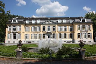
The Morsbroich Museum or Morsbroich Castle Municipal Museum is a German museum of modern art situated in Leverkusen, 20 km north of Cologne.
Kuijõe is a village in Lääne-Nigula Parish, Lääne County, in western Estonia.


