
Söderfjärden is a polder in Ostrobothnia, western Finland, 10 kilometres south of the town of Vaasa. The plain is in an impact crater which was made at least some 640 million years old. The crater's diameter is 6.6 km and its maximum depth is 300 metres. It is filled with Cambrian sandstones leaving only the outer rim visible. There is also a central uplift, which is buried. After rising from the sea due to post-glacial rebound, Söderfjärden was a wetland but was later drained with help of a pump station. It is currently cultivated and is clearly visible from air as a large circular field. This makes Söderfjärden unique among the other impact structures in Finland which are at least partially below sea level.

Çumra is a town and district of Konya Province in the Central Anatolia region of Turkey. According to 2000 census, population of the district is 104,576 of which 42,308 live in the town of Çumra.
Narasingapuram is a Municipality in Attur Taluk, Salem district in the Indian state of Tamil Nadu. As of 2011, the town had a population of 23,084.

Jawahar Navodaya Vidyalaya, Chendayad is a school in Kannur District in the state of Kerala, India established in 1987-86. It comes under the Hyderabad Region of Navodaya Vidyalaya Samiti(NVS).
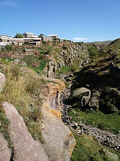
Harich is a village in the Shirak Province of Armenia. Within the village is the Harichavank Monastery of the 8th century. Across the gorge from the monastery is a 3rd millennium BC fortress and tomb field.

Jastrzębiec is a village in the administrative district of Gmina Więcbork, within Sępólno County, Kuyavian-Pomeranian Voivodeship, in north-central Poland. It lies approximately 7 kilometres (4 mi) east of Więcbork, 12 km (7 mi) south-east of Sępólno Krajeńskie, and 38 km (24 mi) north-west of Bydgoszcz.

İşıqlı is a village in the Fizuli Rayon of Azerbaijan.
Haran is a village in the Lerik Rayon of Azerbaijan. The village forms part of the municipality of Hamarmeşə.
Məşədismayıllı is a village in the Zangilan Rayon of Azerbaijan.
Kadzhar is a village in the Agsu Rayon of Azerbaijan.
Podmaleniec is a village in the administrative district of Gmina Staszów, within Staszów County, Świętokrzyskie Voivodeship, in south-central Poland. It lies approximately 5 kilometres (3 mi) north of Staszów and 52 km (32 mi) south-east of the regional capital Kielce.
Mogielnica is a village in the administrative district of Gmina Korczew, within Siedlce County, Masovian Voivodeship, in east-central Poland. It lies approximately 5 kilometres (3 mi) north-west of Korczew, 33 km (21 mi) north-east of Siedlce, and 109 km (68 mi) east of Warsaw.
Szczeciny is a village in the administrative district of Gmina Bartoszyce, within Bartoszyce County, Warmian-Masurian Voivodeship, in northern Poland, close to the border with the Kaliningrad Oblast of Russia. It lies approximately 14 kilometres (9 mi) west of Bartoszyce and 53 km (33 mi) north of the regional capital Olsztyn.
Ławki PGR is a settlement in the administrative district of Gmina Ryn, within Giżycko County, Warmian-Masurian Voivodeship, in northern Poland. It lies approximately 5 kilometres (3 mi) south-east of Ryn, 19 km (12 mi) south-west of Giżycko, and 74 km (46 mi) east of the regional capital Olsztyn.
Łąki Bratiańskie is a village in the administrative district of Gmina Nowe Miasto Lubawskie, within Nowe Miasto County, Warmian-Masurian Voivodeship, in northern Poland.
Bednarki is a village in the administrative district of Gmina Ostróda, within Ostróda County, Warmian-Masurian Voivodeship, in northern Poland.

Žitni Potok is a village in the municipality of Prokuplje, Serbia. According to the 2002 census, the village has a population of 592 people.
Zelenik is a village in the municipality of Kučevo, Serbia. According to the 2002 census, the village has a population of 251 people.
Čar is a village in the municipality of Bujanovac, Serbia. According to the 2002 census, the town has a population of 296 people. Of these, 295 were ethnic Albanians, and 1 other.

Prisjeka Gornja is a village in the municipality of Ključ, Bosnia and Herzegovina.


