Related Research Articles

Hawaii is the largest island in the United States, located in the eponymous state of Hawaii. It is the southeasternmost of the Hawaiian Islands, a chain of volcanic islands in the North Pacific Ocean. With an area of 4,028 square miles (10,430 km2), it has 63% of the Hawaiian archipelago's combined landmass. However, it has only 13% of the archipelago's population. The island of Hawaiʻi is the third largest island in Polynesia, behind the north and south islands of New Zealand.

Hawi (Hawaiian: Hāwī; pronounced [hɐː'viː] is a census-designated place in Hawaiʻi County, Hawaii. The population was 2,268 at the time of the 2020 United States Census.
Kapa'au is an unincorporated community in Hawaiʻi County, Hawaii, United States. Located at the northern tip of the big island of Hawaiʻi, it is celebrated as the birthplace of Kamehameha I.
The following is an alphabetical list of articles related to the U.S. state of Hawaii:

ʻUpolu Airport is a regional airport in Hawaii County, Hawaii, US. Located on the northern tip of the Big Island, it is 3 nautical miles northwest of the unincorporated town of Hawi.
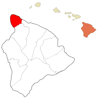
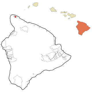
Kohala is the name of the northwest peninsula of the island of Hawaiʻi in the Hawaiian Archipelago. In ancient Hawaii it was often ruled by an independent High Chief called the Aliʻi Nui. In modern times it is divided into two districts of Hawaii County: North Kohala and South Kohala. Locals commonly use the name Kohala to refer to the census-designated places of Halaʻula, Hāwī, and Kapaʻau collectively. The dry western shore is commonly known as the Kohala Coast, which has golf courses and seaside resorts.

Kohala is the oldest of five volcanoes that make up the island of Hawaii. Kohala is an estimated one million years old—so old that it experienced, and recorded, the reversal of Earth's magnetic field 780,000 years ago. It is believed to have breached sea level more than 500,000 years ago and to have last erupted 120,000 years ago. Kohala is 606 km2 (234 sq mi) in area and 14,000 km3 (3,400 cu mi) in volume, and thus constitutes just under 6% of the island of Hawaii.

Most Sacred Heart of Jesus Catholic Church in Hāwī, North Kohala, is a historic parish in the West Hawaii Vicariate of the Catholic Diocese of Honolulu. The parish campus includes an architecturally remarkable historic church, a rectory, a church cemetery, and a parish hall.

Kohala Historical Sites State Monument includes the National Historic Landmark Moʻokini Heiau and the birthplace of Kamehameha I. It is located in remote North Kohala on the Island of Hawaiʻi.
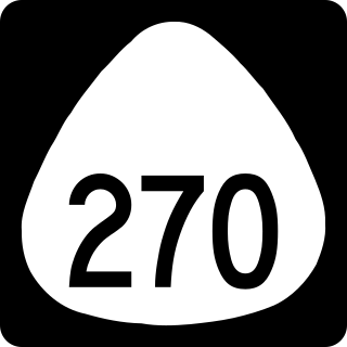
The ʻAkoni Pule Highway, designated as Hawaiʻi Route 270, is a state highway in Hawaii County, Hawaii, United States, that is the main road along the North Kohala Coast on the Island of Hawaiʻi from Kawaihae to ʻUpolu Point and then on to Pololū Valley Lookout. The entire route is 27.0 miles (43.5 km) long.
The Hawaiʻi Belt Road is a modern name for the Māmalahoa Highway and consists of Hawaiʻi state Routes 11, 19, and 190 that encircle the Island of Hawaiʻi. The southern section, between Hilo and Kailua-Kona is numbered as Route 11. The section between Hilo and Waimea is Route 19. Between Waimea and Kailua-Kona, the road is split in two: the original "mauka" route and a "makai" Route 19, completed in 1975, which serves as access to the Kona and Kohala Coast resorts. In the Hawaiian language, mauka means "towards the mountain" and makai means "towards the sea". These terms are commonly used in travel directions.
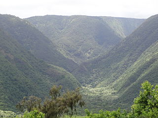
Pololū is the northernmost of a series of erosional valleys forming the east coast of Kohala Mountain on the Island of Hawaiʻi. The word pololū means "long spear" in the Hawaiian language.

Kohala Mountain Road, designated Route 250, travels upon the Kohala mountain on the island of Hawaiʻi in Hawaii County, Hawaii, United States.
The 2006 Kīholo Bay earthquake occurred on October 15 at 07:07:49 local time with a magnitude of 6.7 and a maximum Mercalli intensity of VIII (Severe). The shock was centered 21 kilometers (13 mi) southwest of Puakō and 21 km (13 mi) north of Kailua-Kona, Hawaiʻi, just offshore of the Kona Airport, at a depth of 38.2 km (23.7 mi). It produced several aftershocks, including one that measured a magnitude of 6.1 seven minutes after the main shock. The Pacific Tsunami Warning Center measured a nondestructive tsunami of 4 in (100 mm) on the coast of the Big Island.
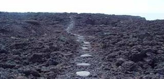
Ala Kahakai National Historic Trail is a 175-mile (282 km) long trail located on the island of Hawaii. It is not yet a single continuous trail, but can be accessed at several broken segments along the coastline of the Big Island. The trail was established to access the traditional Ancient Hawaiian culture along with the natural geology of the island. The trail was established 14 November 2000 as a National Historic Trail which is managed under the National Park Service. The trail has received funds from the Land and Water Conservation Fund.

The Bond District is a collection of historic buildings located in the district of North Kohala on the island of Hawaii. The district has three sections: the homestead of missionaries Ellen and Reverend Elias Bond (1813–1896), Kalahikiola Church, and the Kohala Seminary.

Kaunaʻoa Bay has one of the few white sand beaches of the Kohala Coast, the western side of the island of Hawaiʻi. A historic hotel, the Mauna Kea Beach Hotel, is located on beautiful Kauna'oa.

Māhukona is a former settlement on the island of Hawaiʻi. The extinct submerged volcano Māhukona, off shore and to the south, is named for this area. The settlement was once the terminus of the Hawaiian Railroad.

Kona is a moku or district on the Big Island of Hawaiʻi in the State of Hawaii, known for its Kona coffee and the location of the Ironman World Championship Triathlon. In the current system of administration of Hawaiʻi County, the moku of Kona is divided into North Kona District and South Kona District. The term "Kona" is sometimes used to refer to its largest town, Kailua-Kona. Other towns in Kona include Kealakekua, Keauhou, Holualoa, Hōnaunau and Honalo.
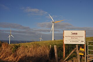
Hawi Wind Farm is a wind farm on Upolu Point, the northern tip of Hawaii's largest island, Hawaiʻi. Commissioned in 2006, it comprises sixteen 660 kW wind turbines manufactured by Vestas, specifically the Vestas V47 turbine. At maximum capacity the farm is able to produce 10.56 MW.
References
- ↑ Vance Miller (1919). Coast Pilot Notes on Hawaiian Islands. US Government Printing Office. p. 8.
| | This Hawaiʻi state location article is a stub. You can help Wikipedia by expanding it. |