1867 Keelung earthquake

Last updated
1867 Keelung earthquake and tsunami
Taiwan relief location map.jpg
Bullseye1.png
Local dateDecember 18, 1867 (1867-12-18)
Local timemorning
Magnitude6.8 ML
7.0–7.24 Mw
Depth10 km (6.2 mi)
Epicenter 25°20′N121°55′E / 25.34°N 121.91°E / 25.34; 121.91
Areas affectedTaiwan
Max. intensity CWB 7
Tsunami15 m (49 ft)
Casualties580 dead; 100+ injured [1]

The 1867 Keelung earthquake occurred off the northern coast of Taiwan on the morning of December 18 with a magnitude of 7.0. It produced strong shaking that seriously damaged the cities of Keelung and Taipei. A tsunami, thought to be the only confirmed destructive of its kind in Taiwan, drowned hundreds and had a run-up exceeding 15 m (49 ft). The total death toll was estimated to be 580 while more than 100 were injured. It was followed by aftershocks that were felt on average ten times a day. [2]

Contents

Keelung and the harbor was seriously affected by the earthquake. It sustained minor damage from the tsunami. Photographed sometime between 1860 and 1890. Keelung City and Harbor, Looking Eastward.jpg
Keelung and the harbor was seriously affected by the earthquake. It sustained minor damage from the tsunami. Photographed sometime between 1860 and 1890.

Tectonic setting

Taiwan is situated on a complex convergent boundary between the Eurasian Plate and the Philippine Sea Plate. [3] Off the northeastern coast of the island, the Philippine Sea Plate subducts northwards beneath the Ryukyu Islands (on the overriding Eurasian Plate) along the Ryukyu Trench. To the south of the island, oceanic crust of the Eurasian Plate subducts beneath eastwards the Philippine Sea Plate along the Manila Trench. Taiwan lies at the junction of the two subduction zones, on the edge of the Asian continental margin (Eurasian Plate), where the northwest–southeast convergence rate is estimated to be 7 cm/year. Continental collision occurs due to convergence of the Asian continental crust with continental crust of the Philippine Sea Plate on the island. Continental crust of the Eurasian Plate is being subducted beneath the island, forming east-dipping thrust faults. [4]

Geology

Multiple studies have been conducted to identify the source of the earthquake and subsequent tsunami. The moment (Mw) and local (ML) magnitudes have been estimated to be 7.0 and 6.8, respectively. Due to the unusually large tsunami, several studies have suggested a submarine landslide or an eruption of the nearby Tatun Volcanic Group was the source of the tsunami. [2]

The lack of historical documentation of the tsunami effects made identifying the fault difficult. Academics have associated the earthquake with a rupture along the Shanchiao Fault, a northeast–southwest trending normal fault. The fault runs onshore from the Taipei area to Jinshan for a length of 40 km (25 mi), and further extends offshore for another 50 km (31 mi). The fault dips towards the southeast at varying angles of 80° onshore to 62° offshore. It was also associated with an earthquake and tsunami in 1694. The Jinshan area formed due to rifting during the Quaternary. [2]

In a 2017 study by Sugawara and others, modelling of the earthquake suggest a 7.24 Mw event with coseismic slip of 6 meters was required to reproduce the tsunami heights reported. The modelled earthquake involved a rupture on the onshore and offshore segments. [2] An earlier study (2016) by Cheng and others estimated a 40 km (25 mi) rupture offshore at a depth of 10 km (6.2 mi) was consistent with the seismic intensity and tsunami reports. The modelled earthquake had a Mw of 7.0 and an epicenter located at 25°20′N121°55′E / 25.34°N 121.91°E / 25.34; 121.91 . [5]

Earthquake

The earthquake occurred at 09:00 or 10:00 local time and produced shaking that lasted 15–30 seconds. In Taipei's Shilin District, many streets were damaged. Buildings collapsed in the city, killing hundreds. Major landslides occurred between Taipei and Keelung, demolishing villages. A large landslide measuring 600–700 m (2,000–2,300 ft) in length was reported at Huangzuishan. The landslide carved a gorge and hot sulfur-laced water flowed. Fissures formed and closed in the ground. [6] More than half the number of homes in Jinshan collapsed. At a beach in Huanggang, hot springs erupted to a height of 9 m (30 ft). One person was killed and many were injured in Huangku when a hot spring erupted from a field. Water from the spring formed a large pond that still exists. Heavy damage was reported at Keelung where collapses buried several hundred residents. In Tamsui, homes collapsed, killing 30, [1] and a British merchant warehouse was extensively damaged. At a nearby town, not far from Tamsui, 150 deaths occurred. An estimated 400 people were killed near the coast. The earthquake also killed more than 300 buffaloes and pigs due to collapses. [5] Land subsidence by between 3 m (9.8 ft) and 7 m (23 ft) was estimated. [2]

Tsunami

The coast of Huanggang was inundated by a tsunami up to 7 meters high. The trace of the Shanchiao Fault is located at the base of the hills. 2020 Huanggang Fishing Port i.jpg
The coast of Huanggang was inundated by a tsunami up to 7 meters high. The trace of the Shanchiao Fault is located at the base of the hills.

Seawater receded approximately five minutes after the earthquake and 25 minutes later, exposed the seafloor by 500 m (1,600 ft). The tsunami struck at 11:00 local time, killed between 70 and 80 people in Jinshan. Tsunami victims were also reported at Yilan and Hualien. [1] Many were killed after they went to the coast to collect fishes after the water receded. Over 100 were injured. [5] A reported tsunami height of 6–7 m (20–23 ft) was observed at Huanggang and Shuiwei. [2] Several Chinese junks were beached and pushed further inland while others sunk. At the harbour in Keelung, the tsunami was 1.75–2.05 m (5 ft 9 in – 6 ft 9 in). The waves destroyed 200 homes. A run-up of over 15 m (49 ft) was estimated at Jinbaoli Old Street and Badouzi. The high run-up at Jinbaoli Old Street was due to a river which allowed waves from the sea to flow upstream. Tsunami damage at Keelung was minimal and only affected the immediate coastal parts of the city. Waves were reported on Heping Island and Tongpan Island. [5] A tsunami deposit was found 6 m (20 ft) above sea level on Heping Island. [7] A 2016 study in Jinshan found tsunami deposits up to 800 m (2,600 ft) inland. [8] An unusual tide was observed at Hangzhou while at the Yangtze River, the water level fell 1.35 m (4 ft 5 in) before rising 1.65 m (5 ft 5 in) in 48 hours. [1] These observations are believed to be the effects of the tsunami. [1]

Volcanic eruption

A report of a submarine eruption at the time of the earthquake and tsunami was vaguely described and published in 1917. [9] It is thought to be the only instance of an earthquake, tsunami and eruption occurring at the same time in the region. [1] The eruption occurred off the northeast coast of the island but nature of it is unknown. [9]

See also

Related Research Articles

<span class="mw-page-title-main">Manila Trench</span> Oceanic trench in the South China Sea, west of Luzon and Mindoro in the Philippines

The Manila Trench is an oceanic trench in the Pacific Ocean, located west of the islands of Luzon and Mindoro in the Philippines. The trench reaches a depth of about 5,400 metres (17,700 ft), in contrast with the average depth of the South China Sea of about 1,500 metres (4,900 ft). It is created by subduction, in which the Sunda Plate is subducting under the Philippine Mobile Belt, producing this almost N-S trending trench. The convergent boundary is terminated to the north by the Taiwan collision zone, and to the south by the Mindoro terrane. It is an area pervaded by negative gravity anomalies.

<span class="mw-page-title-main">1703 Genroku earthquake</span> Earthquake near Edo in the Kantō region, Japan

The 1703 Genroku earthquake occurred at 02:00 local time on December 31. The epicenter was near Edo, the forerunner of present-day Tokyo, in the southern part of the Kantō region, Japan. An estimated 2,300 people were killed by the shaking and subsequent fires. The earthquake triggered a major tsunami which caused many additional casualties, giving a total death toll of at least 5,233, possibly up to 10,000. Genroku is a Japanese era spanning from 1688 through 1704.

<span class="mw-page-title-main">1693 Sicily earthquake</span> 1693 earthquake in Sicily

The 1693 Sicily earthquake struck parts of southern Italy near Sicily, Calabria, and Malta on 11 January at around 21:00 local time. This earthquake was preceded by a damaging foreshock on 9 January. The main quake had an estimated magnitude of 7.4 on the moment magnitude scale, the most powerful in Italian recorded history, and a maximum intensity of XI (Extreme) on the Mercalli intensity scale, destroying at least 70 towns and cities, seriously affecting an area of 5,600 square kilometres (2,200 sq mi) and causing the death of about 60,000 people.

The 1797 Sumatra earthquake occurred at 22:00 local time on February 10. It was the first in a series of great earthquakes that ruptured part of the Sumatran segment of the Sunda megathrust. It caused a damaging tsunami that was particularly severe near Padang, where a 150–200 ton English ship was driven 1 km inland up the Arau River.

The 1868 Hawaii earthquake was the largest recorded in the history of Hawaiʻi island, with an estimated magnitude of 7.9 Mfa and a maximum Mercalli intensity of X (Extreme). The earthquake occurred at 4 p.m. local time on April 2, 1868 and caused a landslide and tsunami that led to 77 deaths. The aftershock sequence for this event has continued up to the present day.

The 1966 Hualien earthquake occurred on March 13 at 00:31 local time of Taiwan. The epicenter was located in the offshore area between Yonaguni Island, Japan and Hualien, Taiwan.

The 1941 Andaman Islands earthquake struck the Andaman Islands on June 26 with a magnitude of 7.7 to 8.1. Details of this event are poorly known as much of Southeast Asia was in the turmoil of World War II. The quake caused severe damage in the Andaman Islands. The tsunami it triggered was reported along the Andaman and Nicobar Islands, India and British Ceylon. There may have been damage and deaths in Bangladesh, Myanmar, and Thailand due to the tsunami.

An earthquake occurred on 1 June 1786 in and around Kangding, in what is now China's Sichuan province. It had an estimated magnitude of about 7.75 and a maximum perceived intensity of X (Extreme) on the Mercalli intensity scale. The initial quake killed 435 people. After an aftershock ten days later, a further 100,000 died when a landslide dam collapsed across the Dadu river.

<span class="mw-page-title-main">2002 Taiwan earthquake</span> Earthquake took place on March 31st 2002

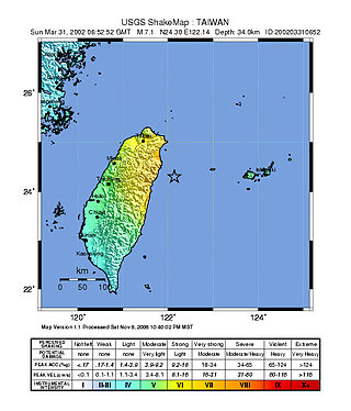
At 14:52 local time on 31 March 2002, an earthquake of magnitude 7.1 on the moment magnitude scale hit Taiwan. The epicenter was offshore from Hualien, which was the most severely affected area with a maximum felt intensity of VII on the Mercalli intensity scale. At least 5 deaths have been reported, with a further 213 injured.

<span class="mw-page-title-main">1812 Ventura earthquake</span> Magnitude 7.1 earthquake in Alta California

The 1812 Ventura earthquake occurred on the morning of December 21 at 11:00 Pacific Standard Time (PST). The 7.1–7.5 magnitude earthquake, with a Modified Mercalli intensity scale rating of X (Extreme), along with its resulting tsunami, caused considerable damage to present-day Santa Barbara and Ventura County, California, which was at the time a territory of the Spanish Empire. One person was killed as a result of the earthquake while another from the aftershock. The earthquake occurred just as the region was recovering from another event on the 8th of December the same year. Both events are thought to have been related.

The 1973 Luhuo earthquake struck near the town of Zhaggo in Garzê Tibetan Autonomous Prefecture of Sichuan Province, China on February 6, 1973, with a magnitude of 7.6 Ms. The earthquake had a maximum intensity of X (Extreme) on the Modified Mercalli intensity scale. It resulted in between 2,175 and 2,204 deaths and a further 2,743 injuries. Serious and widespread destruction occurred in Luhuo County.

The 1761 Lisbon earthquake and its subsequent tsunami occurred in the north Atlantic Ocean and south of the Iberian Peninsula. This violent shock which struck just after noon on 31 March 1761, was felt across many parts of Western Europe. Its direct effects were even observed far north in Scotland and Amsterdam, and to the south in the Canary Islands of Spain. The estimated surface-wave magnitude 8.5 event was the largest in the region, and the most significant earthquake in Europe since the Great Lisbon earthquake of 1755.

The 1674 Ambon earthquake occurred on February 17 between 19:30 and 20:00 local time in the Maluku Islands. The resulting tsunami reached heights of up to 100 metres (330 ft) on Ambon Island killing over 2,000 individuals. It was the first detailed documentation of a tsunami in Indonesia and the largest ever recorded in the country. The exact fault which produced the earthquake has never been determined, but geologists postulate either a local fault, or a larger thrust fault offshore. The extreme tsunami was likely the result of a submarine landslide.

The 1852 Banda Sea earthquake struck on 26 November at 07:40 local time, affecting coastal communities on the Banda Islands. It caused violent shaking lasting five minutes, and was assigned XI on the Modified Mercalli intensity scale in the Maluku Islands. A tsunami measuring up to 8 m (26 ft) slammed into the islands of Banda Neira, Saparua, Haruku and Ceram. The tsunami caused major damage, washing away many villages, ships and residents. At least 60 people were killed in the earthquake and tsunami. The earthquake had an estimated moment magnitude of 7.5 or 8.4–8.8, according to various academic studies.

An earthquake occurred on June 19, 1718, in Tongwei County, Gansu Province, Qing dynasty, present-day China. The estimated surface wave magnitude (Ms ) 7.5 earthquake was designated a maximum Modified Mercalli intensity of X (Extreme), causing tremendous damage and killing 73,000 people.

The 1604 Quanzhou earthquake was an extremely large seismic event that occurred in the Taiwan Strait, off the coast of Fujian Province, near Quanzhou during the Ming dynasty. According to modern-day calculations, the earthquake had a moment magnitude of 8.1 Mw. It is unknown how many casualties resulted from the quake, but major damage was reported.

The 1979 Yapen earthquake occurred on September 12 at 05:17:51 UTC. It had an epicenter near the coast of Yapen Island in Irian Jaya, Indonesia. Measuring 7.5 on the moment magnitude scale and having a depth of 20 km (12 mi), it caused severe damage on the island. At least 115 were killed due to shaking and a moderate tsunami.

On June 5, 1920, a shallow magnitude 8.2 earthquake struck offshore Hualien County, Empire of Japan. It is currently the largest earthquake in Taiwan's modern history.

The 1957 Sangchal earthquake struck northern Iran's Mazandaran province on 2 July 1957. It had a moment magnitude of 6.6 or 7.1 (Mw ), focal depth of 15 km (9.3 mi), and maximum Modified Mercalli intensity of IX (Violent). It devastated many communities in the Alborz Mountains and caused an estimated 1,500 fatalities. Damage was estimated at US$25 milion.

The 1698 Ambato earthquake affected the interior of Ecuador on 20 June at 01:00 local time. The earthquake seismic magnitude ranged from 7.2 to 7.9. Damage was widespread and extreme in the provinces of Tungurahua, Cotopaxi and Chimborazo. The earthquake also triggered mudflows along the Ambato River destroying a city and killing many residents. An estimated 6,500 fatalities were attributed to the shock and thousands more from the landslides.

References

  1. 1 2 3 4 5 6 National Geophysical Data Center / World Data Service (NGDC/WDS), Global Historical Tsunami Database (Data Set), NOAA National Centers for Environmental Information, doi:10.7289/V5PN93H7 , retrieved 10 June 2022
  2. 1 2 3 4 5 6 Sugawara, D.; Yu, N. T.; Yen, J. Y. (2019). "Estimating a Tsunami Source by Sediment Transport Modeling: A Primary Attempt on a Historical/1867 Normal‐Faulting Tsunami in Northern Taiwan". Journal of Geophysical Research: Earth Surface. American Geophysical Union. 124 (7): 1675–1700. Bibcode:2019JGRF..124.1675S. doi:10.1029/2018JF004831. S2CID   197554538.
  3. Sun, Yujun; Liu, Mian; Dong, Shuwen; Zhang, Huai; Shi, Yaolin (2015). "Active tectonics in Taiwan: insights from a 3-D viscous finite element model". Earthquake Science. 28 (5–6): 353–363. Bibcode:2015EaSci..28..353S. doi: 10.1007/s11589-015-0137-9 . S2CID   18681733.
  4. J.G. Liou; L.Y. Hsiao (1 October 1999). "Report #4 on the Chi-Chi (Taiwan) Earthquake: Tectonic Setting and Regional Geology of Taiwan". United States Geological Survey. Archived from the original on 4 February 2020. Retrieved 10 June 2022.
  5. 1 2 3 4 Cheng, Shih-Nan; Shaw, Chen-Fang; Yeh, Yeong Tein (2016). "Reconstructing the 1867 Keelung Earthquake and Tsunami Based on Historical Documents". Terrestrial, Atmospheric and Oceanic Sciences. 27 (3): 431. Bibcode:2016TAOS...27..431C. doi: 10.3319/TAO.2016.03.18.01(TEM) .
  6. National Geophysical Data Center / World Data Service (NGDC/WDS): NCEI/WDS Global Significant Earthquake Database. NOAA National Centers for Environmental Information (1972). "Significant Earthquake Information". NOAA National Centers for Environmental Information (Data Set). doi:10.7289/V5TD9V7K . Retrieved 10 June 2022.
  7. Yu, Neng-Ti; Yen, Jiun-Yee; Yen, I-Chin; Hirakawa, Kazuomi; Chuang, Chao-Ming (2020). "Tsunami deposits and recurrence on a typhoon-prone coast of northern Taiwan from the last millennium". Quaternary Science Reviews. Elsevier. 245: 106488. Bibcode:2020QSRv..24506488Y. doi: 10.1016/j.quascirev.2020.106488 . S2CID   224901625.
  8. Yu, Neng-Ti; Yen, Jiun-Yee; Chen, Wen-Shan; Yen, I-Chin; Liu, Jin-Hsing (2016). "Geological records of western Pacific tsunamis in northern Taiwan: AD 1867 and earlier event deposits". Marine Geology. Elsevier. 372: 1–16. Bibcode:2016MGeol.372....1Y. doi:10.1016/j.margeo.2015.11.010.
  9. 1 2 "Unnamed". Global Volcanism Program . Smithsonian Institution. Archived from the original on 13 July 2007. Retrieved 10 June 2022.