In seismology, an aftershock is a smaller earthquake that follows a larger earthquake, in the same area of the main shock, caused as the displaced crust adjusts to the effects of the main shock. Large earthquakes can have hundreds to thousands of instrumentally detectable aftershocks, which steadily decrease in magnitude and frequency according to a consistent pattern. In some earthquakes the main rupture happens in two or more steps, resulting in multiple main shocks. These are known as doublet earthquakes, and in general can be distinguished from aftershocks in having similar magnitudes and nearly identical seismic waveforms.
A foreshock is an earthquake that occurs before a larger seismic event and is related to it in both time and space. The designation of an earthquake as foreshock, mainshock or aftershock is only possible after the full sequence of events has happened.

The Struma Motorway is a motorway currently under construction in Bulgaria. The motorway is located in the Yugozapaden area in South West Bulgaria, and follows the route Sofia-Pernik-Dupnitsa-Blagoevgrad-Sandanski to Kulata on the border with in Greece. It is part of the Pan-European Corridor IV and also is part of Е79, that runs from Miskolc (Hungary) to Thessaloniki (Greece), via the Romanian cities of Deva and Craiova. This project is under the European Union's Ten-T Priority Projects. The road is also part of the proposed Via Carpatia route.

The 2002 Denali earthquake occurred at 22:12:41 UTC November 3 with an epicenter 66 km ESE of Denali National Park, Alaska, United States. This 7.9 Mw earthquake was the largest recorded in the United States in 37 years. The shock was the strongest ever recorded in the interior of Alaska. Due to the remote location, there were no fatalities and only one injury.
The 1986 Chalfant Valley earthquake struck southern Mono County near Bishop and Chalfant, California at Pacific Daylight Time on July 21. With a moment magnitude of 6.2 and a maximum Mercalli intensity of VI (Strong), the shock injured two people and caused property damage estimated at $2.7 million in the affected areas. There was a significant foreshock and aftershock sequence that included a few moderate events, and was the last in a series of three earthquakes that affected southern California and the northern Owens Valley in July 1986.
The 1992 Murindó earthquake occurred on October 18 at 15:11 UTC with an epicenter in the Department of Chocó, northern Colombia. The shallow magnitude 7.2 earthquake struck northwest of the town of Murindó, killing ten and injured more than a hundred. Thirty-three municipalities were severely damaged.
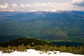
Predel is a mountain saddle (pass) in western Bulgaria between the mountain ranges of Rila to the north and Pirin to the south. It is situated on the territory of the Simitli and Razlog municipalities in Blagoevgrad Province.
The 1968 Borrego Mountain earthquake occurred on April 8, at 18:28 PST, near the unincorporated community of Ocotillo Wells in San Diego County. The moment magnitude (Mw ) 6.6 strike-slip earthquake struck with a focal depth of 11.1 km (6.9 mi). Damage was relatively moderate, and the mainshock was assigned a maximum Modified Mercalli intensity (MMI) of VII. Shaking was felt in Nevada, and Arizona. It was the largest earthquake to strike California since 1952, and its display of afterslip became the subject of scientific interest.
The 1833 Nepal–India earthquake occurred on August 26 at 22:58 local time (NPT). This earthquake had an estimated moment magnitude of 7.6–7.9 and struck with an epicenter somewhere in or near the Kathmandu Valley. The earthquake caused major destruction in numerous towns and villages in Nepal, northern India, and Tibet. The earthquake was also felt in Chittagong, Bangladesh. Despite the extent of the damage, the number of fatalities resulting from the earthquake was surprisingly low, at approximately 500. This was because the mainshock was preceded by two smaller but intense foreshocks earlier that day, causing many residents to take refuge outside their homes.
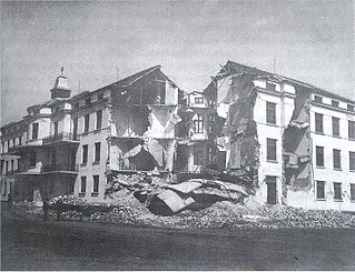
The Chirpan–Plovdiv earthquakes struck central Bulgaria, south of the Sredna Gora on two separate days in April 1928. The event consisted of two main earthquakes that had a moment magnitude of 7.1, occurring four days apart on the 14th and 18th respectively. Major damage was reported, with over 70,000 buildings collapsing. An estimated 127 people died in both earthquakes, with many thousands affected in its aftermath. The two powerful earthquakes could also be felt in Greece, where they also caused significant damage. The cost of damage totaled 5 billion leva.
The 1995 Menglian earthquake or 1995 Myanmar–China earthquake occurred on 12 July at 05:46:43 local time in the Myanmar–China border region. The earthquake had an epicenter on the Myanmar side of the border, located in the mountainous region of Shan State. It registered 7.3 on the Chinese surface wave magnitude scale (Ms ) and 6.8 on the moment magnitude scale (Mw ). With a maximum Mercalli intensity assigned at VIII, the quake killed eleven people and left another 136 injured. Over 100,000 homes in both countries were destroyed and 42,000 seriously damaged. Some damage to structures were also reported in Chiang Mai and Chiang Rai, Thailand. The low death toll from this earthquake was attributed to an early warning issued prior to it happening. Precursor events including foreshocks and some seismic anomalies led to an evacuation of the area before the mainshock struck. It is thought to be one of the few successfully predicted earthquakes in history.
During April 1819, the area around Copiapó in northern Chile was struck by a sequence of earthquakes over a period of several days. The largest of these earthquakes occurred on 11 April at about 15:00 local time, with an estimated magnitude of 8.5. The other two events, on 3 April between 08:00 and 09:00 local time and on 4 April at 16:00 local time, are interpreted as foreshocks to the mainshock on 11 April. The mainshock triggered a tsunami that affected 800 km of coastline and was also recorded at Hawaii. The city of Copiapó was devastated.
The Fars region of Iran was struck by a major earthquake on either 22 April or 5 May 1853. The city of Shiraz and the surrounding area were severely affected, with almost all buildings destroyed. At least 9,000 people were killed, with some estimates reaching 13,000.
The 1980 Nepal earthquake devastated the Nepal–India border region on the evening of July 29. The epicenter of the 6.6 earthquake was located in Nepal, northwest of Khaptad National Park. At least 200 people died and 5,600 were injured in the disaster. Extensive damage occurred on both sides of the border, amounting to 245 million USD.
A series of four mainshocks struck Calabria on March 27–28 and June 9, 1638. The first three earthquakes had moment magnitudes estimated to be 6.6–7.1. On June 9, another mainshock estimated at Mw 6.7 struck the same region, causing further damage and casualties. The four earthquakes resulted in as many as 30,000 fatalities.
The second shock in the 1962 Irpinia earthquake sequence was the largest and most destructive in a series of earthquakes in the southern Apennines. It occurred on 21 August at 18:19 CET, measuring 6.15 and assigned a maximum intensity of IX (Violent). It was preceded by an Mw 5.68 foreshock, and followed by a 5.34 aftershock. The earthquakes resulted in nearly 20 fatalities and significant property losses.
The 1895 Charleston earthquake, also known as the Halloween earthquake, occurred on October 31, at 05:07 CST near Charleston, Missouri. It had an estimated moment magnitude of 5.8–6.6 and evaluated Modified Mercalli intensity of VIII (Severe). The earthquake caused substantial property damage in the states of Missouri, Illinois, Ohio, Alabama, Iowa, Kentucky, Indiana, and Tennessee. Shaking was widespread, being felt across 23 states and even in Canada. At least two people died and seven were injured.
The 1977 Bob–Tangol earthquake struck Kerman province of Iran on December 19 at 23:34 GMT. The earthquake destroyed homes and left thousands homeless. A maximum Modified Mercalli intensity of VII was evaluated based on damage. Between 584 and 665 people perished while a further 500–1,000 were injured. Casualties from the earthquake was considered moderate due to the sparsely populated area it affected. The earthquake measured 5.9 and struck at a depth of 22.7 km (14.1 mi). It had a strike-slip focal mechanism, which was unusual as the source structure was a thrust fault. It was part of a sequence of strong earthquakes along the 400 km (250 mi) Kuh Banan Fault. Preceded by foreshocks the month before, many residents became wary of a larger earthquake and took refuge outside their homes, contributing to the moderate death toll. However, there were none immediately before the mainshock so many were still in their homes when it struck. Aftershocks were felt for several months, some causing additional damage.
The 1977 Khurgu earthquake struck southern Iran near Bandar Abbas in Hormozgan province on the morning of March 22. The earthquake measuring moment magnitude (Mw ) 6.7 struck at a depth of 12.5 km (7.8 mi). Thirty five villages were heavily damaged including over 20 which were destroyed. There were 152–167 people killed and 556 injured.
The 1980 Livermore earthquake occurred on January 24 at 11:00 PST in California. The epicenter of the 5.8 earthquake was a hilly area 12 km (7.5 mi) southeast of Mount Diablo and north of Livermore Valley. The earthquake had a maximum Modified Mercalli intensity of VII. Forty four people were injured and damage across the San Francisco Bay Area totaled $11.5 million, with the majority inflicted at the Lawrence Livermore Laboratory.


