
Terre Haute is a city in and the county seat of Vigo County, Indiana, United States, about 5 miles east of the state's western border with Illinois. As of the 2010 census, the city had a population of 60,785 and its metropolitan area had a population of 170,943.

The term intraplate earthquake refers to a variety of earthquake that occurs within the interior of a tectonic plate; this stands in contrast to an interplate earthquake, which occurs at the boundary of a tectonic plate. Intraplate earthquakes are often called "intraslab earthquakes," especially when occurring in microplates.

Southern Illinois, also known as Little Egypt, is the southern third of Illinois, principally along and south of Interstate 64. Although part of a Midwestern state, this region is aligned in culture more with that of the Upland South than the Midwest. Part of downstate Illinois, it is bordered by the two most voluminous rivers in the United States: the Mississippi below its connecting Missouri River to the west and the Ohio River to the east and south with the Wabash as tributary.

The 1811–1812 New Madrid earthquakes were a series of intense intraplate earthquakes beginning with an initial earthquake of moment magnitude 7.2–8.2 on December 16, 1811, followed by a moment magnitude 7.4 aftershock on the same day. Two additional earthquakes of similar magnitude followed in January and February 1812. They remain the most powerful earthquakes to hit the contiguous United States east of the Rocky Mountains in recorded history. The earthquakes, as well as the seismic zone of their occurrence, were named for the Mississippi River town of New Madrid, then part of the Louisiana Territory and now within the U.S. state of Missouri.

The New Madrid Seismic Zone, sometimes called the New Madrid Fault Line, is a major seismic zone and a prolific source of intraplate earthquakes in the Southern and Midwestern United States, stretching to the southwest from New Madrid, Missouri.

The Wabash Valley is a region located in sections of both Illinois and Indiana. It is named for the Wabash River and, as the name is typically used, spans the middle to the middle-lower portion of the river's valley and is centered at Terre Haute, Indiana. The term Wabash Valley is frequently used in local media in Clinton, Lafayette, Mount Carmel, Princeton, Terre Haute, and Vincennes all of which are either on or near the Lower Wabash River.
The 1950 Assam–Tibet earthquake, also known as the Assam earthquake, occurred on 15 August and had a moment magnitude of 8.7. The epicentre was located in the Mishmi Hills. It is the strongest earthquake ever recorded on land.

The 2003 Alabama earthquake took place on April 29 at 3:59 A.M. Central Daylight Time eight miles (13 km) east-northeast of Fort Payne, Alabama. The number of people who felt this quake was exceptionally high as the earthquake could be felt in 11 states across the East Coast and as far north as southern Indiana. The earthquake was strongly felt throughout metropolitan Atlanta. The Georgia Building Authority was called out to inspect the historic Georgia State Capitol in downtown Atlanta and other state-owned buildings but found no problems. However, this is not out of the ordinary as earthquakes east of the Rocky Mountains can be felt several times the area felt on West Coast earthquakes. The earthquake was given a magnitude 4.6 on the moment magnitude scale by the USGS and reports of the duration of the shaking range from 10 seconds to as long as 45 seconds. It is tied with a 1973 earthquake near Knoxville, Tennessee as the strongest earthquake ever to occur in the Eastern Tennessee Seismic Zone, which is the second most active seismic zone east of the Rocky Mountains, with the New Madrid Seismic Zone the most active.
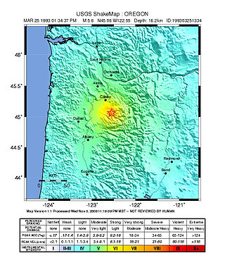
The 1993 Scotts Mills earthquake, also known as the "Spring break quake", occurred in the U.S. state of Oregon on March 25 at 5:34 AM Pacific Standard Time. With a moment magnitude of 5.6 and a maximum perceived intensity of VII on the Mercalli intensity scale, it was the largest earthquake in the Pacific Northwest since the Elk Lake and Goat Rocks earthquakes of 1981. Ground motion was widely felt in Oregon's Willamette Valley, the Portland metropolitan area, and as far north as the Puget Sound area near Seattle, Washington.
The 2008 Illinois earthquake was one of the largest earthquakes ever recorded in the Midwest state of Illinois. This moderate strike-slip shock measured 5.2 on the moment magnitude scale and had a maximum Mercalli intensity of VII (Very strong). It occurred at on April 18 near Bellmont and Mount Carmel, Illinois, within the Wabash Valley Seismic Zone. Earthquakes in this part of the country are often felt at great distances.

The Wabash Valley Seismic Zone is a tectonic region located in the Midwest of the United States, centered on the valley of the Lower Wabash River, along the state line between southeastern Illinois and southwestern Indiana.
The 1663 Charlevoix earthquake occurred on February 5 in New France, and was assessed to have a moment magnitude of between 7.3 and 7.9. The earthquake occurred at 5:30 p.m. local time and was estimated to have a maximum perceived intensity of X (Extreme) on the Mercalli intensity scale. The main shock epicentre is suggested to have occurred along the Saint Lawrence River, between the mouth of the Malbaie River on the north and the mouth of the Ouelle River on the south. A large portion of eastern North America felt the effects. Landslides and underwater sediment slumps were a primary characteristic of the event with much of the destruction occurring near the epicentral region of the St. Lawrence estuary and also in the area of the Saguenay Graben.

The 1968 Illinois earthquake was the largest recorded earthquake in the U.S. Midwestern state of Illinois. Striking at 11:02 am on November 9, it measured 5.4 on the Richter scale. Although no fatalities occurred, the event caused considerable structural damage to buildings, including the toppling of chimneys and shaking in Chicago, the region's largest city. The earthquake was one of the most widely felt in U.S. history, largely affecting 23 states over an area of 580,000 sq mi (1,500,000 km2). In studying its cause, scientists discovered the Cottage Grove Fault in the Southern Illinois Basin.
The 1867 Manhattan earthquake struck Riley County, Kansas, in the United States on April 24, 1867, at 20:22 UTC, or about 14:30 local time. The strongest earthquake to originate in the state, it measured 5.1 on a seismic scale that is based on an isoseismal map or the event's felt area. The earthquake's epicenter was near the town of Manhattan.
The 1865 Memphis earthquake struck southwest Tennessee near the Mississippi River in the United States on August 17 that year. Soon after the Mfa 5.0 earthquake hit, observers said the earth appeared to undulate and waves formed in nearby rivers. The force of the earthquake felled and cracked chimneys in Memphis and New Madrid, Missouri on the other side of the Mississippi. Shaking from the earthquake spread as far as St. Louis, Missouri; Jackson, Mississippi; and Illinois. Apart from the 1811–12 New Madrid earthquakes, only three major events have struck the state of Tennessee, in 1843, 1865, and 1895. Several minor events have taken place as well.

The 2010 Indiana earthquake registered 3.8 on the moment magnitude scale and struck near Greentown and Kokomo on December 30, 2010, at 12:55:21 UTC at a depth of 3 mi. The quake occurred approximately 50 miles north of Indiana's capital, Indianapolis. It joins only three other earthquakes that have affected the northern Indiana area since 1999. The “extremely rare and unprecedented” earthquake had the largest magnitude of a northern Indiana earthquake in 175 years. Despite being considered a rare occurrence, the affected region of northern Indiana lies near many fault lines including the Wabash Valley Seismic Zone and the New Madrid Seismic Zone. Both zones are hotspots for tectonic activity, with the Wabash Valley Fault Zone reaching earthquake depths up to 18 km (11.4 mi.) deep. It was incorrectly recorded by nearby stations as a 4.2 magnitude before being downgraded to 3.8. No significant damage was reported from the incident, but the quake was felt by thousands, spanning across multiple cities and states. Towns as far away as Kalamazoo, Michigan and states as far as Wisconsin and Kentucky reported the earthquake.
The 1934 Hansel Valley earthquake occurred on March 12 at approximately 8:05 a.m. MST with a moment magnitude of 6.6 and a maximum Mercalli intensity of VIII (Severe). The shock originated in the Hansel Valley at the north end of the Great Salt Lake in Utah in the United States. Damage was mostly confined to vulnerable buildings, and two people died. The dip-slip (normal) fault that generated the shock ruptured the surface of the ground and other geologic features were documented. A large aftershock occurred three hours after the initial event and may have caused additional damage.
The 1981 Westmorland earthquake occurred at 05:09 Pacific Daylight Time on April 26. The moderate strike-slip shock took place in the Imperial Valley of Southern California, just north of the Mexico–United States border. No injuries or deaths occurred, but damage was estimated at $1–3 million. With a Mercalli intensity of VII, this was one of fifteen intensity VII or greater shocks in the Imperial Valley that were observed in the 20th century up until April 1981. The region experiences large stand-alone events and earthquake swarms due to its position in an area of complex conditions where faulting transitions from strike-slip movement to the north and divergence to the south.
The Cedar Mountain earthquake of 1932 was one of the largest seismic events in the US state of Nevada. The 7.3 earthquake struck at Cedar Mountain in Western Nevada. Shaking was felt as far as Oregon, Southern California, and the Rocky Mountains area. Nevada is the third most seismically active state in the United States due to ongoing rifting occurring within the North American Plate. Extension or thinning of the crust has resulted in numerous faults accommodating strain, at the same time, producing earthquakes. Since the earthquake occurred in a remote part of the state, damage was limited and no deaths were reported.
The 1895 Charleston earthquake, also known as the Halloween earthquake, occurred on October 31, at 05:07 CST near Charleston, Missouri. It had an estimated moment magnitude of 5.8–6.6 and evaluated Modified Mercalli intensity of VIII (Severe). The earthquake caused substantial property damage in the states of Missouri, Illinois, Ohio, Alabama, Iowa, Kentucky, Indiana, and Tennessee. Shaking was widespread, being felt across 23 states and even in Canada. At least two people died and seven were injured.


