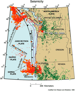
The Gorda Plate, located beneath the Pacific Ocean off the coast of northern California, is one of the northern remnants of the Farallon Plate. It is sometimes referred to as simply the southernmost portion of the neighboring Juan de Fuca Plate, another Farallon remnant.

The Cascadia subduction zone is a convergent plate boundary that stretches from northern Vancouver Island in Canada to Northern California in the United States. It is a very long, sloping subduction zone where the Explorer, Juan de Fuca, and Gorda plates move to the east and slide below the much larger mostly continental North American Plate. The zone varies in width and lies offshore beginning near Cape Mendocino, Northern California, passing through Oregon and Washington, and terminating at about Vancouver Island in British Columbia.

Cape Mendocino, which is located approximately 200 miles (320 km) north of San Francisco, is located on the Lost Coast entirely within Humboldt County, California, United States. At 124° 24' 34" W longitude, it is the westernmost point on the coast of California. The South Cape Mendocino State Marine Reserve and Sugarloaf Island are immediately offshore, although closed to public access due to their protected status. Sugarloaf Island is cited as California's westernmost island.

The Mendocino Fracture Zone is a fracture zone and transform boundary over 4000 km long, starting off the coast of Cape Mendocino in far northern California. It runs westward from a triple junction with the San Andreas Fault and the Cascadia subduction zone to the southern end of the Gorda Ridge. It continues on west of its junction with the Gorda Ridge, as an inactive remnant section which extends for several hundred miles.
The Mendocino Triple Junction (MTJ) is the point where the Gorda plate, the North American plate, and the Pacific plate meet, in the Pacific Ocean near Cape Mendocino in northern California. This triple junction is the location of a change in the broad plate motions which dominate the west coast of North America, linking convergence of the northern Cascadia subduction zone and translation of the southern San Andreas Fault system. The Gorda plate is subducting, towards N50ºE, under the North American plate at 2.5 – 3 cm/yr, and is simultaneously converging obliquely against the Pacific plate at a rate of 5 cm/yr in the direction N115ºE. The accommodation of this plate configuration results in a transform boundary along the Mendocino Fracture Zone, and a divergent boundary at the Gorda Ridge.
The 1957 Andreanof Islands earthquake took place on March 9 with a moment magnitude of 8.6 and a maximum Mercalli intensity of VIII (Severe). It occurred south of the Andreanof Islands group, which is part of the Aleutian Islands arc. The event occurred along the Aleutian Trench, the convergent plate boundary that separates the Pacific Plate and the North American Plates near Alaska. A basin wide tsunami followed, with effects felt in Alaska and Hawaii. Total losses were around $5 million.
The 2006 Kamchatka earthquake occurred on . This shock had a moment magnitude of 7.6 and a maximum Mercalli intensity of X (Extreme). The hypocenter was located near the coast of Koryak Autonomous Okrug at an estimated depth of 22 km, as reported by the International Seismological Centre. This event caused damage in three villages and was followed by a number of large aftershocks. Two M6.6 earthquakes struck on April 29 at 16:58 UTC and again on May 22 at 11:12 UTC. These earthquakes caused no deaths; however, 40 people were reported injured.
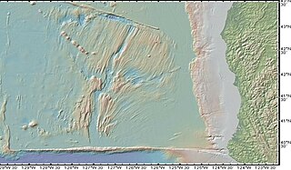
The Gorda Ridge, aka Gorda Ridges tectonic spreading center, is located roughly 200 kilometres (120 mi) off the northern coast of California and southern Oregon. Running NE – SW it is roughly 300 kilometres (190 mi) in length. The ridge is broken into three segments; the northern ridge, central ridge, and the southern ridge, which contains the Escanaba Trough.
The 1995 Neftegorsk earthquake occurred on 28 May at on northern Sakhalin Island in the Russian Far East. It was the most destructive earthquake known within the current territory of Russia, with a magnitude of 7.1 and maximum Mercalli intensity of IX (Violent) that devastated the oil town of Neftegorsk, where 1,989 of its 3,977 citizens were killed, and another 750 injured.

The 2010 Eureka earthquake occurred on January 9 at 4:27:38 pm PST offshore of Humboldt County, California, United States. The magnitude was measured 6.5 on the scale, and its epicenter was located offshore in the Pacific Ocean 33 miles (53 km) west of the nearest major city, Eureka. Additionally, there was a separate earthquake further offshore of Eureka on February 4 with a slightly lower magnitude of 5.9. It was also the most significant earthquake in the Eureka area in terms of magnitude since the 1992 Cape Mendocino earthquakes. It was felt from Santa Cruz County, California in the south, to Eugene, Oregon in the north and to the east as far as Reno, Nevada.
The 1986 Chalfant Valley earthquake struck southern Mono County near Bishop and Chalfant, California at Pacific Daylight Time on July 21. With a moment magnitude of 6.2 and a maximum Mercalli intensity of VI (Strong), the shock injured two people and caused property damage estimated at $2.7 million in the affected areas. There was a significant foreshock and aftershock sequence that included a few moderate events, and was the last in a series of three earthquakes that affected southern California and the northern Owens Valley in July 1986.
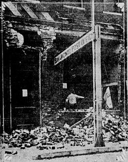
The 1992 Cape Mendocino earthquakes occurred along the Lost Coast of Northern California on April 25 and 26. The three largest events were the M7.2 thrust mainshock that struck near the unincorporated community of Petrolia midday on April 25 and two primary strike-slip aftershocks measuring 6.5 and 6.6 that followed early the next morning. The sequence encompassed both interplate and intraplate activity that was associated with the Mendocino Triple Junction, a complex system of three major faults that converge near Cape Mendocino. The total number of aftershocks that followed the events exceeded 2,000.
The 1979 Coyote Lake earthquake occurred at on August 6 with a moment magnitude of 5.7 and a maximum Mercalli Intensity of VII. The shock occurred on the Calaveras Fault near Coyote Lake in Santa Clara County, California and resulted in a number of injuries, including some that required hospitalization. Most of the $500,000 in damage that was caused was non-structural, but several businesses were closed for repairs. Data from numerous strong motion instruments was used to determine the type, depth, and extent of slip. A non-destructive aftershock sequence that lasted throughout the remainder of the month was of interest to seismologists, especially with regard to fault creep, and following the event local governments evaluated their response to the incident.
The 1957 San Francisco earthquake occurred on March 22 at 11:44:22 local time with a moment magnitude of 5.7 and a maximum Mercalli Intensity of VII. It was located just off the San Francisco Peninsula near the San Andreas Fault and was felt in a limited portion of Northern and Central California. There was a non-destructive foreshock and aftershock sequence that lasted for several months. With financial losses of around US$1 million, damage was considered minimal, with one death and forty injuries.
The 1980 Eureka earthquake occurred on November 8 at along the northern coastal area of California in the United States. With a moment magnitude of 7.3 and a maximum Mercalli intensity of VII, this strike-slip earthquake was the largest to occur in California in 28 years. Although damage was considered light, several loss estimates equaled or exceeded $2 million, and six injuries resulted when two vehicles came down with the partial collapse of a highway overpass on US 101 in Fields Landing. The north coast of California experiences frequent plate boundary earthquakes near the Mendocino Triple Junction and intraplate events also occur within the Gorda Plate.
The 1918 San Jacinto earthquake occurred in extreme eastern San Diego County in Southern California on April 21 at . The shock had a moment magnitude of 6.7 and a maximum Mercalli intensity of IX (Violent). Several injuries and one death occurred with total losses estimated to be $200,000.
The 1946 Sagaing earthquakes struck central Burma at 15:17 local time on September 12. The first earthquake measured a magnitude of 8.0 Mw and was followed-up by a 7.7 Mw main shock. Both events remain some of the largest in the country since the 1762 Arakan earthquake.
The 1981 Westmorland earthquake occurred at 05:09 Pacific Daylight Time on April 26. The moderate strike-slip shock took place in the Imperial Valley of Southern California, just north of the Mexico–United States border. No injuries or deaths occurred, but damage was estimated at $1–3 million. With a Mercalli intensity of VII, this was one of fifteen intensity VII or greater shocks in the Imperial Valley that were observed in the 20th century up until April 1981. The region experiences large stand-alone events and earthquake swarms due to its position in an area of complex conditions where faulting transitions from strike-slip movement to the north and divergence to the south.
