Related Research Articles

In seismology, an earthquake swarm is a sequence of seismic events occurring in a local area within a relatively short period. The time span used to define a swarm varies, but may be days, months, or years. Such an energy release is different from the situation when a major earthquake is followed by a series of aftershocks: in earthquake swarms, no single earthquake in the sequence is obviously the main shock. In particular, a cluster of aftershocks occurring after a mainshock is not a swarm.

Many major earthquakes have occurred in the region of the Kamchatka Peninsula in far eastern Russia. Events in 1737, 1923 and 1952, were megathrust earthquakes and caused tsunamis. There are many more earthquakes and tsunamis originating from the region.
The 1999 Hector Mine earthquake occurred in Southern California, United States, on October 16 at 02:46:50 PDT. Its moment magnitude was 7.1 and the earthquake was preceded by 12 foreshocks, the largest of which had a magnitude of 3.8. The event is thought to have been triggered by the 1992 Landers earthquake which occurred seven years earlier. It also deformed nearby faults vertically and horizontally. The earthquake's hypocenter was at a depth of 20 kilometers and its epicenter at 34.603° N 116.265° W.

The 1992 Landers earthquake occurred on Sunday, June 28 with an epicenter near the town of Landers, California, in San Bernardino County. The shock had a moment magnitude of 7.3 and a maximum Mercalli intensity of IX (Violent).
Mogul is a census-designated place (CDP) in Washoe County, Nevada, United States. It lies on the western side of the Reno–Sparks Metropolitan Statistical Area, just off Interstate 80. The population was 1,290 at the 2010 census. Prior to 2010, the community was part of the Verdi-Mogul CDP.

In the early morning hours of August 16, 1931, a powerful earthquake occurred in West Texas with a maximum Mercalli intensity of VIII (Severe). Estimates of its magnitude range between 5.8–6.4 mb, making it the most powerful earthquake ever recorded in Texas history. Its epicenter was near the town of Valentine, Texas; there, the earthquake caused damage to many homes and buildings. The earthquake may have been caused by movement along oblique-slip faulting in West Texas, the most seismically-active region in the state. Shaking from the earthquake was perceptible within a 400 mi (640 km) radius of the epicenter, affecting four U.S. states and northern Mexico. Several foreshocks and aftershocks accompanied the primary temblor, with the aftershocks continuing until at least November 3, 1931. The main earthquake caused no fatalities, though several people sustained minor injuries; the damage in Valentine amounted to $50,000–$75,000.
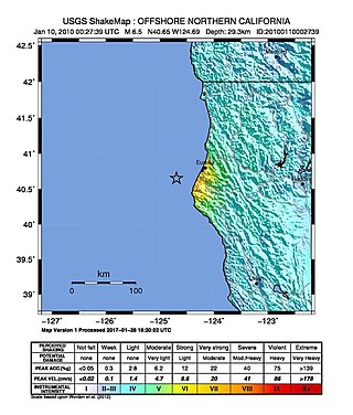
The 2010 Eureka earthquake occurred on January 9 at 4:27:38 pm PST offshore of Humboldt County, California, United States. The magnitude was measured 6.5 on the Mw scale, and its epicenter was located offshore in the Pacific Ocean 33 miles (53 km) west of the nearest major city, Eureka. Additionally, there was a separate earthquake further offshore of Eureka on February 4 with a slightly lower magnitude of 5.9. It was also the most significant earthquake in the Eureka area in terms of magnitude since the 1992 Cape Mendocino earthquakes. It was felt from Santa Cruz County, California in the south, to Eugene, Oregon in the north and to the east as far as Reno, Nevada.

The 1997 Punitaqui earthquake occurred at 01:03 UTC on October 15. It had an estimated magnitude of 7.1 Mwc. This earthquake was one of the most destructive in the epicentral area compared to other events of subduction of the same size. The extensive damage to structures was the result of an amplification effect on the ground and the poor quality of building materials, this reflects the potential for damage incurred in an intraplate earthquake with vertical fault and how it can be much greater than what which can cause one of interplate of similar magnitude, and caused severe damage in Chilean cities of La Serena, Vicuña, Ovalle, Illapel and Punitaqui.
The 1995 Gulf of Aqaba earthquake occurred on November 22 at 06:15 local time and registered 7.3 on the Mw scale. The epicenter was located in the central segment of the Gulf of Aqaba, the narrow body of water that separates Egypt's Sinai Peninsula from the western border of Saudi Arabia. At least 8 people were killed and 30 were injured in the meizoseismal area.
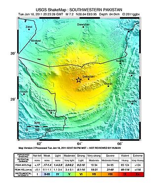
The 2011 Dalbandin earthquake occurred on 18 January at 01:23 a.m. local time with a moment magnitude of Mw 7.2 and a maximum Mercalli intensity of VII. The shock occurred in a sparsely populated area of Balochistan, caused moderate damage, three deaths, and some injuries.

The Sagaing Fault is a major fault in Myanmar, a mainly continental right-lateral transform fault between the Indian Plate and Sunda Plate. It links the divergent boundary in the Andaman Sea with the zone of active continental collision along the Himalayan front. It passes through populated cities of Mandalay, Yamethin, Pyinmana, the capital Naypyidaw, Toungoo and Pegu before dropping off into the Gulf of Martaban, running for a total length of over 1200 kilometers.
The 2011 Guerrero earthquake struck with a moment magnitude of 5.7 in southern Mexico at 08:24 local time on 5 May. It was positioned west of Ometepec, Guerrero, with a focal depth of 24 km (14.9 mi), and was lightly felt in many adjacent areas.

The June 2011 Christchurch earthquake was a shallow magnitude 6.0 Mw earthquake that occurred on 13 June 2011 at 14:20 NZST. It was centred at a depth of 7 km (4.3 mi), about 5 km (3 mi) south-east of Christchurch, which had previously been devastated by a magnitude 6.2 MW earthquake in February 2011. The June quake was preceded by a magnitude 5.9 ML tremor that struck the region at a slightly deeper 8.9 km (5.5 mi). The United States Geological Survey reported a magnitude of 6.0 Mw and a depth of 9 km (5.6 mi).
The 2011 Colorado earthquake occurred on August 22 at 11:46 PM MDT with a moment magnitude of 5.3 and a maximum Mercalli intensity of VII. The epicenter of the intraplate earthquake was 10 mi (20 km) west northwest of Trinidad, Colorado, and 180 mi (290 km) south of Denver, according to the United States Geological Survey (USGS). It was the largest natural earthquake to affect Colorado for more than a hundred years.

The 2011 Oklahoma earthquake was a 5.7 magnitude intraplate earthquake which occurred near Prague, Oklahoma on November 5 at 10:53 p.m. CDT in the U.S. state of Oklahoma. The epicenter of the earthquake was in the vicinity of several active wastewater injection wells. According to the United States Geological Survey (USGS), it was the most powerful earthquake ever recorded in Oklahoma; this record was surpassed by the 2016 Oklahoma earthquake. The previous record was a 5.5 magnitude earthquake that struck near the town of El Reno in 1952. The quake's epicenter was approximately 44 miles (71 km) east-northeast of Oklahoma City, near the town of Sparks and was felt in the neighboring states of Texas, Arkansas, Kansas and Missouri and even as far away as Tennessee and Wisconsin. The quake followed several minor quakes earlier in the day, including a 4.7 magnitude foreshock. The quake had a maximum perceived intensity of VIII (Severe) on the Mercalli intensity scale in the area closest to the epicenter. Numerous aftershocks were detected after the main quake, with a few registering at 4.0 magnitude.

The Oklahoma earthquake swarms are an ongoing series of human activity-induced earthquakes affecting central Oklahoma, southern Kansas, northern Texas since 2009. Beginning in 2009, the frequency of earthquakes in the U.S. state of Oklahoma rapidly increased from an average of fewer than two 3.0+ magnitude earthquakes per year since 1978 to hundreds each year in the 2014–17 period. Thousands of earthquakes have occurred in Oklahoma and surrounding areas in southern Kansas and North Texas since 2009. Scientific studies attribute the rise in earthquakes to the disposal of wastewater produced during oil extraction that has been injected more deeply into the ground.
The 2016 Oklahoma earthquake occurred on September 3, 2016 near Pawnee, Oklahoma. Measuring 5.8 on the moment magnitude scale, it is the strongest in state history. At 5.8 magnitude, this ties it with the 2011 Virginia earthquake, which was determined after it struck to be the most powerful quake in the eastern United States in the preceding 70 years.
The 2019 Ridgecrest earthquakes of July 4 and 5 occurred north and northeast of the town of Ridgecrest, California located in Kern County and west of Searles Valley. They included three initial main shocks of Mw magnitudes 6.4, 5.4, and 7.1, and many perceptible aftershocks, mainly within the area of the Naval Air Weapons Station China Lake. Eleven months later, a Mw 5.5 aftershock took place to the east of Ridgecrest. The first main shock occurred on Thursday, July 4 at 10:33 a.m. PDT, approximately 18 km (11.2 mi) ENE of Ridgecrest, and 13 km (8.1 mi) WSW of Trona, on a previously unnoticed NE-SW trending fault where it intersects the NW-SE trending Little Lake Fault Zone. This quake was preceded by several smaller earthquakes, and was followed by more than 1,400 detected aftershocks. The M 5.4 and M 7.1 quakes struck on Friday, July 5 at 4:08 a.m. and 8:19 p.m. PDT approximately 10 km (6 miles) to the northwest. The latter, now considered the mainshock, was the most powerful earthquake to occur in the state in 20 years. Subsequent aftershocks extended approximately 50 km (~30 miles) along the Little Lake Fault Zone.
In 1954, the state of Nevada was struck by a series of earthquakes that began with three magnitude 6.0+ events in July and August that preceded the Mw 7.1–7.3 mainshock and M 6.9 aftershock, both on December 12. All five earthquakes are among the largest in the state, and the largest since the Cedar Mountain earthquake of 1932 and Pleasant Valley event in 1915. The earthquake was felt throughout much of the western United States.
The 1914 Reno earthquakes were a series of earthquakes in February and April 1914 in Reno, Nevada and the surrounding area. The 6.0 magnitude foreshock occurred on February 18, 1914, at 10:17am local time. The 6.4 magnitude main quake occurred at 12:34am local time.
References
- ↑ "Special Earthquake Report". Nevada Seismological Laboratory. Archived from the original on May 9, 2008. Retrieved May 10, 2008.
- ↑ Griffith, Martin (April 26, 2008). "Reno urged to prepare for worse as earthquakes continue". Associated Press. Retrieved October 11, 2008.