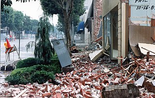
The 1987 Whittier Narrows earthquake occurred in the southern San Gabriel Valley and surrounding communities of Southern California, United States, at on October 1. The moderate magnitude 5.9 blind thrust earthquake was centered several miles north of Whittier in the town of Rosemead, had a relatively shallow depth, and was felt throughout southern California and southern Nevada. Many homes and businesses were affected, along with roadway disruptions, mainly in Los Angeles and Orange counties. Damage estimates ranged from $213–358 million, with 200 injuries, three directly-related deaths, and five additional fatalities that were associated with the event.
The 2008 Illinois earthquake was one of the largest earthquakes ever recorded in the Midwest state of Illinois. This moderate strike-slip shock measured 5.2 on the moment magnitude scale and had a maximum Mercalli intensity of VII (Very strong). It occurred at on April 18 near Bellmont and Mount Carmel, Illinois, within the Wabash Valley Seismic Zone. Earthquakes in this part of the country are often felt at great distances.

The 1915 Pleasant Valley earthquake occurred at in north-central Nevada. With a moment magnitude of 6.8, a surface wave magnitude of 7.7, and a maximum Mercalli intensity of X (Extreme), it was the strongest earthquake ever recorded in the state.

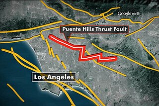
The Puente Hills Fault is an active geological fault that is located in the Los Angeles Basin in California. The thrust fault was discovered in 1999 and runs about 40 km (25 mi) in three discrete sections from the Puente Hills region in the southeast to just south of Griffith Park in the northwest. The fault is known as a blind thrust fault, as the fault plane does not extend to the surface. Large earthquakes on the fault are relatively infrequent but computer modeling has indicated that a major event could have substantial impact in the Los Angeles area. The fault is now thought to be responsible for one moderate earthquake in 1987 and another light event that took place in 2010, with the former causing considerable damage and deaths.
The 1202 Syria earthquake struck at about dawn on 20 May 1202 with an epicenter in southwestern Syria. The earthquake is estimated to have killed around 30,000 people. It was felt over an extensive area, from Sicily to Mesopotamia and Anatolia to upper Egypt, mostly affecting the Ayyubid Sultanate and the Kingdom of Jerusalem. The cities of Tyre, Acre and Nablus were heavily damaged. A magnitude of 7.6 has been estimated with damage up to XI on the Mercalli intensity scale.
The 1965 Puget Sound earthquake occurred at 08:28 AM PDT on April 29 within the Puget Sound region of Washington state. It had a magnitude of 6.7 on the moment magnitude scale and a maximum perceived intensity of VIII (Severe) on the Mercalli intensity scale. It caused the deaths of seven people and about $12.5–28 million in damage. There were no recorded aftershocks.
The 1872 North Cascades earthquake occurred at in central Washington Territory. A maximum Mercalli intensity of VIII (Severe) was assessed for several locations, though less intense shaking was observed at many other locations in Washington, Oregon, and British Columbia. Some of these intermediate outlying areas reported V (Moderate) to VII shaking, but intensities as high as IV (Light) were reported as far distant as Idaho and Montana. Due to the remote location of the mainshock and a series of strong aftershocks, damage to structures was limited to a few cabins close to the areas of the highest intensity.
The 1892 Laguna Salada earthquake occurred at . It had an estimated moment magnitude of 7.1–7.2 and a maximum perceived intensity of VIII (Severe). The shock was centered near the Mexico–United States border and takes its name from a large dry lake bed in Baja California, Mexico. There were no reported casualties, but the event affected the then largely-uninhabited areas of northern Mexico and Southern California.
An earthquake occurred on 1 June 1786 in and around Kangding, in what is now China's Sichuan province. It had an estimated magnitude of about 7.75 and a maximum perceived intensity of X (Extreme) on the Mercalli intensity scale. The initial quake killed 435 people. After an aftershock ten days later, a further 100,000 died when a landslide dam collapsed across the Dadu river.
The 2014 Murmuri earthquake occurred on August 18 in the Zagros Mountains of Iran with a moment magnitude of 6.2 and a maximum Mercalli intensity of VIII (Severe). The thrust earthquake injured 60–330 people and was followed by a number of high intensity aftershocks.

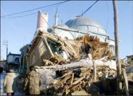
The Afyon Province of western Turkey was struck by an earthquake measuring 6.5 on 3 February 2002 at 10:11 local time. It had a maximum felt intensity of VIII (Severe) on the Modified Mercalli intensity scale. It damaged hundreds of buildings and caused the deaths of 44 people and a further 318 injuries.
The 2020 Central Idaho earthquake occurred in the western United States on March 31, 2020, at 5:52 PM MDT, near Ruffneck Peak in the Sawtooth Mountains of central Idaho, 72 miles (116 km) northeast of Boise and 19 miles (31 km) northwest of Stanley. It had a magnitude of 6.5 and was felt with a maximum intensity of VIII.
The 1988 Lancang–Gengma earthquakes, also known as the 11.6 earthquakes by the Chinese media were a pair of devastating seismic events that struck Lancang and Gengma counties, Yunnan, near the border with Shan State, Burma. The earthquake measured moment magnitude (Mw ) 7.0 and was followed 13 minutes later by a 6.9 Mw shock. These earthquakes were assigned a maximum China seismic intensity of IX and X, respectively. Between 748 and 939 people were killed; more than 7,700 were injured. Both earthquakes resulted in US$270 million in damage and economic losses. Moderately large aftershocks continued to rock the region, causing additional casualties and damage.
The 1994 Mascara earthquake occurred on August 18 at 02:13 local time with an epicenter in a rural part of Algeria. The earthquake measured 5.8 on the moment magnitude scale (Mw ) and had a depth of 10 km (6.2 mi). It caused the deaths of 171 people, left up to 12,500 homeless, and destroyed thousands of homes in Mascara Province. Many homes were damaged or destroyed due to poor building quality which collapsed on the inhabitants and resulted in a majority of the casualties. The national government launched a rapid response effort in its aftermath.
The 1995 Menglian earthquake or 1995 Myanmar–China earthquake occurred on 12 July at 05:46:43 local time in the Myanmar–China border region. The earthquake had an epicenter on the Myanmar side of the border, located in the mountainous region of Shan State. It registered 7.3 on the Chinese surface wave magnitude scale (Ms ) and 6.8 on the moment magnitude scale (Mw ). With a maximum Mercalli intensity assigned at VIII, the quake killed eleven people and left another 136 injured. Over 100,000 homes in both countries were destroyed and 42,000 seriously damaged. Some damage to structures were also reported in Chiang Mai and Chiang Rai, Thailand. The low death toll from this earthquake was attributed to an early warning issued prior to it happening. Precursor events including foreshocks and some seismic anomalies led to an evacuation of the area before the mainshock struck. It is thought to be one of the few successfully predicted earthquakes in history.
The 1941 Sa'dah earthquake or the Jabal Razih earthquake occurred on January 11 in Razih District of the Mutawakkilite Kingdom of Yemen. The earthquake had a surface-wave magnitude of 5.8–6.5 and a shallow focal depth. Despite the moderate size of this earthquake, an estimated 1,200 people perished and at least 200 injured. With a maximum MSK-64 intensity assigned at VIII, it destroyed many villages and collapsed homes in the region of North Yemen.
The 1979 Yapen earthquake occurred on September 12 at 05:17:51 UTC. It had an epicenter near the coast of Yapen Island in Irian Jaya, Indonesia. Measuring 7.5 on the moment magnitude scale and having a depth of 20 km (12 mi), it caused severe damage on the island. At least 115 were killed due to shaking and a moderate tsunami.
The 1804 Almería earthquake was a highly destructive seismic event in the Province of Almería, southern Spain. It occurred on August 25 at 8:25 pm local time. The mainshock had a maximum intensity assigned VIII–IX on the European macroseismic scale (EMS), and an estimated moment magnitude of 6.2–6.4 Mw . At least 400 people were reported killed.
The 1957 Farsinaj earthquake struck Hamadan, Iran on 13 December at 05:15 local time. The moment magnitude 6.5 earthquake destroyed 211 villages, killed approximately 1,130 people, and left another 900 injured.


