1992 Cape Mendocino earthquakes

Last updated

1992 Cape Mendocino earthquakes
Relief map of California.png
Green pog.svg
San Francisco
Green pog.svg
Eureka
Green pog.svg
Monterey
Bullseye1.png
Usa edcp relief location map.png
UTC  time1992-04-25 18:06:06
ISC  event 297295
USGS-ANSS ComCat
Local dateApril 25, 1992 (1992-04-25)
Local time11:06:06 PDT
Duration9 seconds [1]
Magnitude7.2 Mw [2]
Depth10.5 km (7 mi) [3]
Epicenter 40°20′N124°14′W / 40.33°N 124.23°W / 40.33; -124.23 [2]
Areas affected North Coast (California)
United States
Total damage$48.3–75 million [2] [4]
Max. intensity IX (Violent) [3]
Peak acceleration2.2 g (est) [5]
TsunamiYes
Aftershocks6.5 Mw April 26 at 0:41
6.6 Mw April 26 at 4:18
Casualties98–356 injuries [3] [4]

The 1992 Cape Mendocino earthquakes (or 1992 Petrolia earthquakes) occurred along the Lost Coast of Northern California on April 25 and 26. The three largest events were the M7.2 thrust mainshock that struck near the unincorporated community of Petrolia midday on April 25 and two primary strike-slip aftershocks measuring 6.5 and 6.6 that followed early the next morning. The sequence encompassed both interplate and intraplate activity that was associated with the Mendocino Triple Junction, a complex system of three major faults (including the Cascadia subduction zone, San Andreas Fault, and Mendocino Fracture Zone) that converge near Cape Mendocino. The total number of aftershocks that followed the events exceeded 2,000.

Contents

The three shocks damaged and destroyed homes and businesses in Humboldt County and injured up to 356 people, but the single largest loss was due to a post-earthquake fire that consumed a business center in Scotia. Accelerometers that had been in place in the Cape Mendocino area since the late 1970s recorded the event and the readings were moderate to strong, with the exception of the instruments closest to the epicenter, which went off scale a few seconds into the recording. No surface ruptures were present in the epicentral area, but landslides closed roads and railroad tracks for at least a week while cleanup took place. Also discovered was about 1 m (3 ft 3 in) of coastal uplift near Cape Mendocino and Punta Gorda.

As the largest earthquake in California since the 1989 Loma Prieta event, the mainshock caused a non-destructive tsunami that quickly reached the coast, and eventually Alaska and Hawaii several hours later. The tsunami was significant not because of its run-up, but because of the speed with which it reached the coast and for how long the waves persisted. Other strong earthquakes have affected the same area, with some that were clearly associated with the (interplate) Mendocino Fracture Zone, and others (like the two shocks on April 26) were intraplate earthquakes that ruptured within the Gorda Plate, but events that are unequivocally associated with the Cascadia subduction zone are infrequent.

Tectonic setting

The northernmost coastal area is one of California's most seismically active regions and, in a 50-year period, the area including the Mendocino Fracture Zone at the southern flank of the Gorda Plate generated about 25 percent of all seismic energy unleashed in the state. The Mendocino Triple Junction (strike-slip/strike-slip/trench) formed 29–30 mya at 31° N (west of present-day Baja California) when the Pacific-Farallon spreading center initially approached the subduction zone off the coast of western North America. Simultaneously, the Rivera Triple Junction shifted to the southeast to its current position at 23° N. Once the Pacific Plate and North American Plate connected, the boundary became that of a transform fault (San Andreas) due to the northwestward motion of the Pacific Plate relative to the North American Plate. The San Andreas Fault continues to lengthen to the northwest and the southeast as the two triple junctions continue their transient motion. [6] [7]

North of the Mendocino Triple Junction, the Gorda plate is subducting beneath the North American Plate at the Cascadia subduction zone, with a convergence rate of 2.5–3 centimeters (0.98–1.18 in) per year, but comparisons with other subduction zones have led to a belief that the convergence may be taking place aseismically. The distinct lack of interplate events there has generated contention regarding the zone's seismic hazard, though there are strong indications that substantial historic events have occurred in the Pacific Northwest. Submerged wetlands and raised marine terraces both illustrate the presence of past events, and radiocarbon dating of rock layers has revealed that three seismic events took place in the last 2,000 years, with the most recent event being the 1700 Cascadia earthquake. The Gorda Plate is undergoing a process of intraplate deformation and experiences large intraplate earthquakes that may be the result of north–south compression of the oceanic crust along the Mendocino Fracture Zone. [6] [8]

Earthquakes

USGS Shakemap - 1992 Cape Mendocino earthquake.jpg
USGS Shakemap - 1992 Cape Mendocino earthquake (second aftershock).jpg
USGS ShakeMaps showing the mainshock (left) and the second (and slightly stronger) 4:18 PDT aftershock's intensity

The region near the triple junction experiences high seismicity, with more than 60 earthquakes of intensity VI (Strong) or greater or magnitudes ≥ 5.5 since 1853. The mainshock in the sequence (11:06 a.m. Pacific Daylight Time) occurred onshore, 4 kilometers (2.5 mi) west of Petrolia at a depth of 10.5 kilometers, and was among an infrequent number of earthquakes with fault-plane solutions that conveyed evidence of slip at the Cascadia subduction zone. While the focal mechanism indicated slip on a thrust fault striking N.10°W with a shallow dip of 13° to the east-northeast, the rupture most likely propagated to the west, based on the mainshock location at the southeastern boundary of the aftershock zone. Investigation of more than 1,200 surveys from the North Coast area led to the assignment of an intensity rating of IX (Violent) on the Modified Mercalli scale for the region near Petrolia. [8]

In opposition to the mainshock that was located onshore, the two large strike-slip aftershocks occurred the following morning (12:41 a.m. and 4:18 a.m. PDT) and were located offshore, 30 km (19 mi) to the west of the main shock within the Gorda Plate. Both shocks (M6.5 and 6.6) were of intensity VIII (Severe), occurred at a depth of 20 kilometers (12 mi), and exhibited right-lateral motion. Of the several thousand aftershocks in the sequence, none were found to have occurred on the Mendocino Fracture Zone, but numerous events were located on the eastward projection of that fault. The mainshock's rupture duration was described as a smooth nine seconds, while the two aftershocks had more complex and slightly longer ruptures of 14–15 seconds. That the two strike-slip events followed a thrust event indicated a strong coupling of stresses at the North American and Gorda plate boundaries, and underscored the convoluted nature of the interconnected faults in that area. [6] [8]

Damage

Cars crushed by a fallen brick facade in Ferndale, California Ferndale damage 1992.png
Cars crushed by a fallen brick facade in Ferndale, California

The initial event caused a number of wood-framed homes in Scotia to come off their foundations while the porches of some other homes became detached. The 25 MW cogeneration plant there that used wood waste products to power both the lumber company and the town suffered damage and both lumber mills were shut down for several weeks. In Rio Dell, across the Eel River from Scotia, glass store fronts along the main street were shattered and numerous buildings slipped into a culvert along Monument Road. In Petrolia (the small community closest to the epicenter) the general store (combined with a post office and gas station) was destroyed by fire, and in Fortuna, damage totaled $4 million. A six figure portion of that figure was due to losses at the high school's gymnasium. [9]

The two aftershocks the following morning were separated by less than four hours and both caused at least as much damage as the mainshock. A large fire was triggered following the first aftershock at a shopping center in Scotia that destroyed four businesses, with the resulting damage at that site alone estimated at $15 million, and was the largest individual financial misfortune of the sequence of earthquakes. The water supply in Rio Dell was terminated when the water main was severed at the abutment to the Eel River bridge and power outages were widespread throughout Humboldt County. Some were mere seconds while others lasted for hours, but the hydroelectric plant's performance at Ruth Reservoir was deemed acceptable, and power that was not generated locally was unaffected. [10]

The Alford-Nielson House in Ferndale fell off its foundation in the quake (O'Brien 1993, p. 81). It was later restored. Alford-Nielson House 1992 EarthquakeDamages.jpg
The Alford-Nielson House in Ferndale fell off its foundation in the quake (O'Brien 1993, p. 81). It was later restored.

Damage estimates were as high as $75 million, one third of which was due to bridges and roads, and the remainder of the costs were structure-related. The American Red Cross compiled damage statistics in the county and the totals included 906 damaged homes and apartments. Almost half of those were severely damaged and an additional 200 homes were destroyed. In Petrolia, the post office, three businesses, and 44 homes were destroyed, and another 68 residences were damaged. In Ferndale, 29 homes were knocked off their foundations and 126 were damaged, along with 51 businesses. In Rio Dell, 127 buildings were damaged or destroyed. With 98 homes and 41 businesses experiencing some form of damage, the city of Fortuna experienced losses totaling $3.8 million. Eureka and Arcata (25 miles (40 km) north of the Eel River valley) saw light damage and no injuries, while the unincorporated communities of Weott and Carlotta reported damage of less than $2 million combined. [11] [12]

Strong motion

As the largest earthquake in California since the October 1989 event in the Santa Cruz Mountains, the mainshock near Petrolia produced some of the highest ground motions ever recorded (at that time) by the California Strong Motion Instrumentation Program (CSMIP). Fourteen existing CSMIP stations comprising 84 strong motion sensors recorded the event, ten of which were ground response stations. The remaining four were located on structures, including a Highway 101 overpass in Rio Dell, a dam, a one-story supermarket in Fortuna, and a 5-story residential building in Eureka. The supermarket, residential building, and dam were 28, 50, and 75 kilometers distant from the epicenter respectively, and recorded peak accelerations of 0.46 g, 0.34 g, and 0.15 g. An accelerograph at the Painter Street overpass (a concrete bridge, 24 km (15 mi) from the epicenter) recorded a free field acceleration of 0.55 g and an instrument on the structure saw an amplified peak of 1.23 g during the mainshock. [13]

The CSMIP Cape Mendocino station was installed in 1978 and was located just 4 kilometers (2.5 mi) from the epicenter on the slope of a ridge in the coast ranges. The instruments there had been mounted on a concrete platform adjacent to a roadway and remained firmly secured to the rock platform following the shocks. A landslide came within 50 meters (160 ft) of the device and left debris on the road, but a lack of large rocks close to the instrument and no cracking of the rocks near the platform left geologists with no clear explanation for the extraordinarily high vertical component reading of 1.85 g. The tri-axial analog accelerometer that was in use was physically limited to that value and all three traces had uniformly significant values at three seconds into the recording. A post-earthquake lab test of the seismometer and an inspection of the photographically enlarged accelerogram revealed that the limit was hit twice, with a maximum deflection of 31 mm, as the needle bounced off the unit's mass. An extrapolation of the vertical record led to a maximum acceleration estimate of 2.2 g for that site, and the unit was eventually replaced with a higher capacity digital device. [13]

Ground effects

A landslide west of Ferndale Landslide1992CapeMendocino.jpg
A landslide west of Ferndale

The sequence of earthquakes caused widespread landslides from the coast to east of Scotia and from the northern extent of the Eel River basin near Thompson Hill to south of Petrolia. Most of these were existing landslides that had been re-initiated and the largest of the slides were either slumps or bedding plane failures along the coastal bluffs. Several slump failures between Guthrie Creek and Oil Creek stretched from the bluffs towards the shore for a distance of 150 meters (490 ft), leaving some of the slide to be eroded by the surf. The road between Ferndale and Petrolia was closed for more than a week where about six mostly minor landslides blocked the passage, with the roadway itself sustaining light damage due to sliding or settlement of the road fill in a few instances. One of the largest slides occurred along the railroad tracks at the Scotia bluffs where previous slides had taken place. That slide also took about a week to clear. [14]

During a survey following the earthquake, evidence of coastal uplift was detected when dead and decomposing intertidal organisms were discovered along the beaches in the epicentral region. Further investigation revealed that a 15 km (9.3 mi) portion of the shoreline between Cape Mendocino and near Punta Gorda had been uplifted by as much as 1 m (3 ft 3 in) near the middle portion, and decreasing amounts near the outer portions of the affected area. Evidence of previous events has been found in the form of sequential marine terraces along the coast, with periodic events creating shelves at 300, 1,700, 3,000, and 5,000 years before present. No surface ruptures were found during aerial surveillance, but lateral spreading features were observed on a channel near the mouth of the Eel River. [14]

Tsunami

The mainshock generated a small tsunami that was recorded by the National Oceanic and Atmospheric Administration's sea level gauge stations on the coasts of northern California, Oregon, and Hawaii. The series of waves first came ashore at the North Spit station in Eureka after a 26-minute travel time, but the largest surges were seen just to the north at Crescent City and arrived close to low tide, a condition that would have lowered the risk had the surges had a destructive capacity. The first packet of energy reached that location in 47 minutes and had a maximum wave height of 35 cm (14 in), and a second, larger packet arrived later with a maximum amplitude of 53 cm (21 in). The waves were also detected to the south in the interior of San Francisco Bay at Alameda, but with a considerable delay (135 minutes after the mainshock), due to the shallow waters of the bay and the shelf surrounding the bay's entrance. The speed a tsunami travels is directly related to the depth of the water in which it is traversing. The tsunami was detected farther to the south in Monterey, for example, after just a 64-minute travel time, due to the deeper offshore waters and those in the Monterey Bay. [15]

At 3,720 kilometers (2,310 mi) distant, the tsunami was perceptible on the Hawaiian island of Maui at Kahului. The location of the islands lay on a great circle route that is also perpendicular to the region of (presumed) uplifted land at the coast near Cape Mendocino and any energy distributed would be the strongest in that direction. No tsunami was detected at Johnston Atoll, 5,050 kilometers (3,140 mi) from Cape Mendocino in the north Pacific Ocean, but bottom pressure recorders registered a maximum amplitude of .4 cm (0.16 in) in 4,000 meters (13,000 ft) of water in the Gulf of Alaska, with 3.75 hours of travel time. While the waves generated by the earthquake were limited, the event demonstrated the rapid onset of tsunami hazards, giving little time for coastal residents to prepare. In this case, the strongest waves came ashore in Crescent City three to four hours after the initial surge, but it is possible to be just the opposite where the first waves could be the strongest. Also detailed from this event was that the wave hazard can be of long duration, with wave action lingering for more than eight hours. [16]

Other events

The Mendocino Fault is seismically active with mostly small and moderate earthquakes, but the largest event that was unequivocally associated with the fault was the M6.9 earthquake on September 1, 1994, at 125.8 W longitude. Aftershocks of that event with corresponding dextral strike-slip focal mechanisms occurred farther to the east and close to the Mendocino Triple Junction. Another large event (7.3–7.6) occurred on January 31, 1922 (with an aftershock of M7+ the next day) but the sources of these shocks could not be determined with any precision as the first seismographs did not arrive in the area until 1932. Due to their offshore epicenters all of these events caused little damage though were felt across a broad area. Previous Gorda plate events include the July 13 and August 17, 1991, shocks of 6.8 and 7.1 and the M7.3 event on November 10, 1980, west of Arcata. [6] [7]

Related Research Articles

<span class="mw-page-title-main">Gorda Plate</span> One of the northern remnants of the Farallon Plate

The Gorda Plate, located beneath the Pacific Ocean off the coast of northern California, is one of the northern remnants of the Farallon Plate. It is sometimes referred to as simply the southernmost portion of the neighboring Juan de Fuca Plate, another Farallon remnant.

<span class="mw-page-title-main">Cascadia subduction zone</span> Convergent plate boundary that stretches from northern Vancouver Island to Northern California

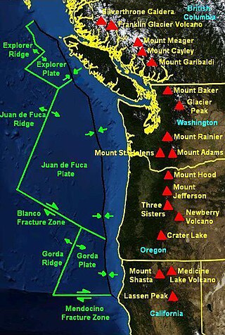
The Cascadia subduction zone is a 960 km fault at a convergent plate boundary, about 112-160 km off the Pacific Shore, that stretches from northern Vancouver Island in Canada to Northern California in the United States. It is capable of producing 9.0+ magnitude earthquakes and tsunamis that could reach 30m. The Oregon Department of Emergency Management estimates shaking would last 5-7 minutes along the coast, with strength and intensity decreasing further from the epicenter. It is a very long, sloping subduction zone where the Explorer, Juan de Fuca, and Gorda plates move to the east and slide below the much larger mostly continental North American Plate. The zone varies in width and lies offshore beginning near Cape Mendocino, Northern California, passing through Oregon and Washington, and terminating at about Vancouver Island in British Columbia.

<span class="mw-page-title-main">Cape Mendocino</span> Cape in Mendocino County, California, United States

Cape Mendocino, which is located approximately 200 miles (320 km) north of San Francisco, is located on the Lost Coast entirely within Humboldt County, California, United States. At 124° 24' 34" W longitude, it is the westernmost point on the coast of California. The South Cape Mendocino State Marine Reserve and Sugarloaf Island are immediately offshore, although closed to public access due to their protected status. Sugarloaf Island is cited as California's westernmost island.

<span class="mw-page-title-main">Mendocino Fracture Zone</span> Geologic fracture zone and transform boundary near northern California

The Mendocino Fracture Zone is a fracture zone and transform boundary over 4000 km long, starting off the coast of Cape Mendocino in far northern California. It runs westward from a triple junction with the San Andreas Fault and the Cascadia subduction zone to the southern end of the Gorda Ridge. It continues on west of its junction with the Gorda Ridge, as an inactive remnant section which extends for several hundred miles.

<span class="mw-page-title-main">Mendocino Triple Junction</span> Point where the Gorda plate, the North American plate, and the Pacific plate meet

The Mendocino Triple Junction (MTJ) is the point where the Gorda plate, the North American plate, and the Pacific plate meet, in the Pacific Ocean near Cape Mendocino in northern California. This triple junction is the location of a change in the broad plate motions which dominate the west coast of North America, linking convergence of the northern Cascadia subduction zone and translation of the southern San Andreas Fault system. This region is can be characterized by transform fault movement, the San Andreas also by transform strike slip movement, and the Cascadia subduction zone by a convergent plate boundary subduction movement. The Gorda plate is subducting, towards N50ºE, under the North American plate at 2.5 – 3 cm/yr, and is simultaneously converging obliquely against the Pacific plate at a rate of 5 cm/yr in the direction N115ºE. The accommodation of this plate configuration results in a transform boundary along the Mendocino Fracture Zone, and a divergent boundary at the Gorda Ridge. This area is tectonically active historically and today. The Cascadia subduction zone is known to be capable of producing megathrust earthquakes on the order of MW 9.0.

<span class="mw-page-title-main">1952 Severo-Kurilsk earthquake</span> Sixth most powerful on record; in Russia

The 1952 Severo-Kurilsk earthquake struck off the coast of the Kamchatka Peninsula. The 9.0 Mw earthquake triggered a major tsunami that hit Severo-Kurilsk, Kuril Islands, Sakhalin Oblast, Russian SFSR, USSR, on 5 November 1952 at 04:58 local time. This led to the destruction of many settlements in Sakhalin Oblast and Kamchatka Oblast, while the main impact struck the town of Severo-Kurilsk. It was the most powerful earthquake ever recorded in Russia, and the fifth most powerful earthquake ever recorded in the world since modern seismography began in 1900.

<span class="mw-page-title-main">2010 Eureka earthquake</span> January 2010 earthquake in California

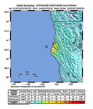
The 2010 Eureka earthquake occurred on January 9 at 4:27:38 pm PST offshore of Humboldt County, California, United States. The magnitude was measured 6.5 on the Mw scale, and its epicenter was located offshore in the Pacific Ocean 33 miles (53 km) west of the nearest major city, Eureka. Additionally, there was a separate earthquake further offshore of Eureka on February 4 with a slightly lower magnitude of 5.9. It was also the most significant earthquake in the Eureka area in terms of magnitude since the 1992 Cape Mendocino earthquakes. It was felt from Santa Cruz County, California in the south, to Eugene, Oregon in the north and to the east as far as Reno, Nevada.

The 1979 Coyote Lake earthquake occurred at 10:05:24 local time on August 6 with a moment magnitude of 5.7 and a maximum Mercalli Intensity of VII. The shock occurred on the Calaveras Fault near Coyote Lake in Santa Clara County, California and resulted in a number of injuries, including some that required hospitalization. Most of the $500,000 in damage that was caused was non-structural, but several businesses were closed for repairs. Data from numerous strong motion instruments was used to determine the type, depth, and extent of slip. A non-destructive aftershock sequence that lasted throughout the remainder of the month was of interest to seismologists, especially with regard to fault creep, and following the event local governments evaluated their response to the incident.

The 1980 Eureka earthquake occurred on November 8 at 02:27:34 local time along the northern coastal area of California in the United States. With a moment magnitude of 7.3 and a maximum Mercalli intensity of VII, this strike-slip earthquake was the largest to occur in California in 28 years. Although damage was considered light, several loss estimates equaled or exceeded $2 million, and six injuries resulted when two vehicles came down with the partial collapse of a highway overpass on US 101 in Fields Landing. The north coast of California experiences frequent plate boundary earthquakes near the Mendocino Triple Junction and intraplate events also occur within the Gorda Plate.

The 1932 Eureka earthquake occurred on June 6 at 00:44:26 local time along the northern coastal area of California in the United States. With a moment magnitude of 6.4 and a maximum Mercalli intensity of VIII (Severe), this earthquake left one person dead from a falling chimney and several injured. The shock was the largest in the area since 1923 and was felt in southern Oregon and northern California.

The 2004 Les Saintes earthquake occurred at 07:41:07 local time on November 21, 2004 with a moment magnitude of 6.3 and maximum European macroseismic intensity of VIII. The shock was named for Îles des Saintes "Island of the Saints", a group of small islands to the south of Guadeloupe, which is an overseas department of France. Although it occurred near the Lesser Antilles subduction zone, this was an intraplate, normal fault event. It resulted in one death, 13 injuries, and 40 people being made homeless, but the overall damage was considered moderate. A small, nondestructive tsunami was reported, but run-up and inundation distances were difficult to measure due to a storm that occurred on the day of the event. Unusual effects at a volcanic lake on Dominica were also documented, and an aftershock caused additional damage three months later.

The 1898 Mare Island earthquake occurred in Northern California on March 30 at 23:43 local time with a moment magnitude of 5.8–6.4 and a maximum Mercalli intensity of VIII–IX (SevereViolent). Its area of perceptibility included much of northern and central California and western Nevada. Damage amounted to $350,000 and was most pronounced on Mare Island, a peninsula in northern San Francisco Bay. While relatively strong effects there were attributed to vulnerable buildings, moderate effects elsewhere in the San Francisco Bay Area consisted of damaged or partially collapsed structures, and there were media reports of a small tsunami and mostly mild aftershocks that followed.

On January 1, 1996, at 4:05 p.m. Central Indonesia Time, an earthquake with an epicenter in the Makassar Strait struck north of Minahasa on the island of Sulawesi, Indonesia. The earthquake measured 7.9 on the moment magnitude scale and was centered off Tolitoli Regency in Central Sulawesi, or 25 km from the Tonggolobibi village. A tsunami of 2–4 m (6.6–13.1 ft) was triggered by this earthquake as a result. At least 350 buildings were badly damaged, nine people died and 63 people were injured.

<span class="mw-page-title-main">2013 Craig, Alaska earthquake</span> Earthquake in Alaska and British Columbia

The 2013 Craig, Alaska earthquake struck on January 5, at 12:58 am (UTC–7) near the city of Craig and Hydaburg, on Prince of Wales Island. The Mw 7.5 earthquake came nearly three months after an Mw  7.8 quake struck Haida Gwaii on October 28, in 2012. The quake prompted a regional tsunami warning to British Columbia and Alaska, but it was later cancelled. Due to the remote location of the quake, there were no reports of casualties or damage.

The Nemuro-Oki earthquake in scientific literature, occurred on June 17 at 12:55 local time. It struck with an epicenter just off the Nemuro Peninsula in northern Hokkaidō, Japan. It measured 7.8–7.9 on the moment magnitude scale (Mw ), 8.1 on the tsunami magnitude scale (Mt ) and 7.4 on the Japan Meteorological Agency magnitude scale (MJMA ).

<span class="mw-page-title-main">2021 Chignik earthquake</span> 7th largest earthquake in the US

An earthquake occurred off the coast of the Alaska Peninsula on July 28, 2021, at 10:15 p.m. local time. The large megathrust earthquake had a moment magnitude of 8.2 according to the United States Geological Survey (USGS). A tsunami warning was issued by the National Oceanic and Atmospheric Administration (NOAA) but later cancelled. The mainshock was followed by a number of aftershocks, including three that were of magnitude 5.9, 6.1 and 6.9 respectively.

The 2021 South Sandwich Islands earthquakes were a pair of powerful earthquakes, followed by many strong aftershocks which struck along the South Sandwich Trench in August 2021. The quakes measured 7.5 and 8.1 on the moment magnitude scale, according to the United States Geological Survey. The mainshock is tied with another event in 1929 as the largest earthquake ever recorded in this region, and is tied with the 2021 Kermadec Islands earthquake as the second largest earthquake of 2021.

The 1979 Yapen earthquake occurred on September 12 at 05:17:51 UTC. It had an epicenter near the coast of Yapen Island in Irian Jaya, Indonesia. Measuring 7.5 on the moment magnitude scale and having a depth of 20 km (12 mi), it caused severe damage on the island. At least 115 were killed due to shaking and a moderate tsunami.

The 1979 Saint Elias earthquake occurred near noon local time on the 28th of February. It measured Mw 7.4–7.6. Though the maximum recorded Modified Mercalli intensity was VII, damage was minimal and there were no casualties due to the remoteness of the faulting. The epicenter lies near the Alaskan border between America and Canada.

On December 20, 2022, a magnitude 6.4 earthquake struck Ferndale, California in Humboldt County, United States at 10:34:25 UTC, or 2:34 a.m. PST.

References

  1. Velasco, Ammon & Lay 1994, p. 711
  2. 1 2 3 Toppozada, T. R.; Branum, D. (2004), "California earthquake history", Annals of Geophysics, 47 (2–3): 511
  3. 1 2 3 Oppenheimer et al. 1993, p. 433
  4. 1 2 National Geophysical Data Center / World Data Service (NGDC/WDS) (1972), Significant Earthquake Database (Data Set), National Geophysical Data Center, NOAA, doi:10.7289/V5TD9V7K
  5. Shakal et al. 1992, p. 6
  6. 1 2 3 4 Velasco, Ammon & Lay 1994 , pp. 711–713
  7. 1 2 Yeats, R. (2012), Active Faults of the World, Cambridge University Press, pp. 83–84, ISBN   978-0-521-19085-5
  8. 1 2 3 Oppenheimer et al. 1993 , pp. 433–436
  9. O'Brien 1993 , pp. 43, 55
  10. O'Brien 1993 , pp. 55, 67, 71
  11. Bernard, E. N. (1997), "Reducing tsunami hazards along U.S. coastlines", Perspectives on Tsunami Hazard Reduction: Observations, Theory and Planning, Springer, p. 189, ISBN   978-0-7923-4811-5
  12. O'Brien 1993 , pp. 71, 72
  13. 1 2 Shakal et al. 1992 , pp. 1–6, 11–14
  14. 1 2 Green, R. K.; Sawyer, T. L. (1993). Geotechnical aspects of the Petrolia earthquake. Proceedings: Third International Conference on Case Histories in Geotechnical Engineering, St. Louis, Missouri, June 1–4, 1993. Paper No. 14.08. pp. 1715–1717.
  15. Gonzalez, Bernard & Satake 1995 , pp. 151–154
  16. Gonzalez, Bernard & Satake 1995 , pp. 154–156

Sources

Further reading