
The San Andreas Fault is a continental right-lateral strike-slip transform fault that extends roughly 1,200 kilometers (750 mi) through the Californias. It forms the tectonic boundary between the Pacific Plate and the North American Plate. Traditionally, for scientific purposes, the fault has been classified into three main segments, each with different characteristics and a different degree of earthquake risk. The average slip rate along the entire fault ranges from 20 to 35 mm per year.

The Hayward Fault Zone is a right-lateral strike-slip geologic fault zone capable of generating destructive earthquakes. The fault was first named in the Lawson Report of the 1906 San Francisco Earthquake in recognition of its involvement in the earthquake of 1868. This fault is about 119 km (74 mi) long, situated mainly along the western base of the hills on the east side of San Francisco Bay. It runs through densely populated areas, including Richmond, El Cerrito, Berkeley, Oakland, San Leandro, Castro Valley, Hayward, Union City, Fremont, and San Jose.
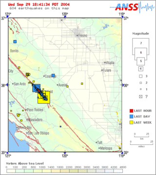
Parkfield earthquake is a name given to various large earthquakes that occurred in the vicinity of the town of Parkfield, California, United States. The San Andreas fault runs through this town, and six successive magnitude 6 earthquakes occurred on the fault at unusually regular intervals, between 12 and 32 years apart, between 1857 and 1966. The most recent significant earthquake to occur here happened on September 28, 2004.
The 1999 Hector Mine earthquake occurred in Southern California, United States, on October 16 at 02:46:50 PDT. Its moment magnitude was 7.1 and the earthquake was preceded by 12 foreshocks, the largest of which had a magnitude of 3.8. The event is thought to have been triggered by the 1992 Landers earthquake which occurred seven years earlier. It also deformed nearby faults vertically and horizontally. The earthquake's hypocenter was at a depth of 20 kilometers and its epicenter at 34.603° N 116.265° W.
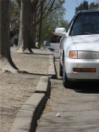
The Calaveras Fault is a major branch of the San Andreas Fault System that is located in northern California in the San Francisco Bay Area. Activity on the different segments of the fault includes moderate and large earthquakes as well as aseismic creep. The last large event was the magnitude 6.2 1984 Morgan Hill event. The most recent moderate earthquakes were the magnitude 5.1 event on 25 October 2022, and the magnitude 5.6 2007 Alum Rock event.
Seismic magnitude scales are used to describe the overall strength or "size" of an earthquake. These are distinguished from seismic intensity scales that categorize the intensity or severity of ground shaking (quaking) caused by an earthquake at a given location. Magnitudes are usually determined from measurements of an earthquake's seismic waves as recorded on a seismogram. Magnitude scales vary on what aspect of the seismic waves are measured and how they are measured. Different magnitude scales are necessary because of differences in earthquakes, the information available, and the purposes for which the magnitudes are used.

The 1992 Landers earthquake occurred on Sunday, June 28 with an epicenter near the town of Landers, California, in San Bernardino County. The shock had a moment magnitude of 7.3 and a maximum Mercalli intensity of IX (Violent).

The 1868 Hayward earthquake occurred in the San Francisco Bay Area, California, United States on October 21. With an estimated moment magnitude of 6.3–6.7 and a maximum Mercalli intensity of IX (Violent), it was the most recent large earthquake to occur on the Hayward Fault Zone. It caused significant damage and a number of deaths throughout the region, and was known as the "Great San Francisco earthquake" prior to the 1906 San Francisco earthquake and fire.
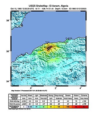
The 1980 El Asnam earthquake occurred on October 10 at with a moment magnitude of 7.1 and a maximum Mercalli intensity of X (Extreme). The shock occurred in the Algerian town of El Asnam. The shocks were felt over 550 km (340 mi) away, with the initial earthquake lasting 35 seconds. It was the largest earthquake in Algeria, and was followed three hours later by a magnitude 6.2 aftershock. The earthquake created about 42 km (26 mi) of surface rupture and had a vertical slip of up to 4.2 m (14 ft). No foreshocks were recorded. The earthquake was found to have occurred very close to the epicenter of the 1954 Chlef earthquake using joint epicenter determination techniques. It occurred at a previously unknown reverse fault.

The 2010 Baja California earthquake occurred on April 4 with a moment magnitude of 7.2 and a maximum Mercalli intensity of VII. The shock originated at south of Guadalupe Victoria, Baja California, Mexico.
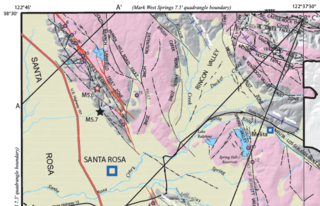
At 04:56 and 06:19 UTC on October 2, 1969, a pair of earthquakes of magnitude 5.6 and 5.7, respectively, struck the city of Santa Rosa, California, killing one person and damaging buildings. The maximum felt intensity for the two events was VII and VIII (Severe) respectively on the Mercalli intensity scale. The $8.35 million cost of the earthquakes went mostly to replace buildings damaged beyond repair. There were at least 200 aftershocks after the initial pair of earthquakes. At the time they were the largest earthquakes to affect the northern San Francisco Bay Area since the 1906 San Francisco earthquake.

The Sagaing Fault is a major fault in Myanmar, a mainly continental right-lateral transform fault between the Indian Plate and Sunda Plate. It links the divergent boundary in the Andaman Sea with the zone of active continental collision along the Himalayan front. It passes through populated cities of Mandalay, Yamethin, Pyinmana, the capital Naypyidaw, Toungoo and Pegu before dropping off into the Gulf of Martaban, running for a total length of over 1200 kilometers.
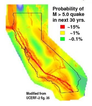
The 2008 Uniform California Earthquake Rupture Forecast, Version 2, or UCERF2, is one of a series of earthquake forecasts prepared for the state California by the Working Group on California Earthquake Probabilities (WGCEP), collaboration of the U.S. Geological Survey, the California Geological Survey, and the Southern California Earthquake Center, with funding from the California Earthquake Authority. UCERF2 was superseded by UCERF3 in 2015.

The 2014 South Napa earthquake occurred in the North San Francisco Bay Area on August 24 at . At 6.0 on the moment magnitude scale and with a maximum Mercalli intensity of VIII (Severe), the event was the largest in the San Francisco Bay Area since the 1989 Loma Prieta earthquake. The epicenter of the earthquake was located to the south of Napa and to the northwest of American Canyon on the West Napa Fault.
The 1979 Coyote Lake earthquake occurred at on August 6 with a moment magnitude of 5.7 and a maximum Mercalli Intensity of VII. The shock occurred on the Calaveras Fault near Coyote Lake in Santa Clara County, California and resulted in a number of injuries, including some that required hospitalization. Most of the $500,000 in damage that was caused was non-structural, but several businesses were closed for repairs. Data from numerous strong motion instruments was used to determine the type, depth, and extent of slip. A non-destructive aftershock sequence that lasted throughout the remainder of the month was of interest to seismologists, especially with regard to fault creep, and following the event local governments evaluated their response to the incident.

The 2015 Uniform California Earthquake Rupture Forecast, Version 3, or UCERF3, is the latest official earthquake rupture forecast (ERF) for the state of California, superseding UCERF2. It provides authoritative estimates of the likelihood and severity of potentially damaging earthquake ruptures in the long- and near-term. Combining this with ground motion models produces estimates of the severity of ground shaking that can be expected during a given period, and of the threat to the built environment. This information is used to inform engineering design and building codes, planning for disaster, and evaluating whether earthquake insurance premiums are sufficient for the prospective losses. A variety of hazard metrics can be calculated with UCERF3; a typical metric is the likelihood of a magnitude M 6.7 earthquake in the 30 years since 2014.
The 1990 Upland earthquake occurred at on February 28 with a moment magnitude of 5.7 and a maximum Mercalli Intensity of VII. This left-lateral strike-slip earthquake occurred west of the San Andreas Fault System and injured thirty people, with total losses of $12.7 million. Many strong motion instruments captured the event, with an unexpectedly high value seen on water tank near the epicentral area.
The 1838 San Andreas earthquake is believed to be a rupture along the northern part of the San Andreas Fault in June 1838. It affected approximately 100 km of the fault, from the San Francisco Peninsula to the Santa Cruz Mountains. It was a strong earthquake, with an estimated moment magnitude of 6.8 to 7.2, making it one of the largest known earthquakes in California. The region was lightly populated at the time, although structural damage was reported in San Francisco, Oakland, and Monterey. It is unknown whether there were fatalities. Based on geological sampling, the fault created approximately 1.5 meters of slip.

An earthquake occurred off the coast of the Alaska Peninsula on July 28, 2021, at 10:15 p.m. local time. The large megathrust earthquake had a moment magnitude of 8.2 according to the United States Geological Survey (USGS). A tsunami warning was issued by the National Oceanic and Atmospheric Administration (NOAA) but later cancelled. The mainshock was followed by a number of aftershocks, including three that were of magnitude 5.9, 6.1 and 6.9 respectively.
The 1992 Joshua Tree earthquake occurred at 9:50:25 p.m. PDT on April 22 in Southern California. The magnitude 6.2 earthquake struck under the Little San Bernardino Mountains, near the town of Joshua Tree, California. Though no deaths were reported, the earthquake caused 32 injuries. A maximum Mercalli intensity of VII was observed in Joshua Tree and caused light to moderate damage. The event preceded the Landers and Big Bear earthquakes by two months but is now recognized as the beginning of a series of major earthquakes that culminated in two events on June 28, 1992.


