This article needs additional citations for verification .(May 2011) |
1921 census of Newfoundland was a population census taken in Newfoundland and Labrador in the year 1921.
This article needs additional citations for verification .(May 2011) |
1921 census of Newfoundland was a population census taken in Newfoundland and Labrador in the year 1921.
The original census was organized in the order of the houses on the street or path in each community. People living next door to each other or within the same house would be identified by the order of the names in the census. The 1921 census was the only census taken in Newfoundland to have the question, "Are you Micmac Indian?", [1] as there were many Mi'kmaq people in Newfoundland at the time. The "Report on the Census of Newfoundland and Labrador, 1921" explains the census after it was taken. "The census was taken under the Cap. 20, Consolidated Statutes (Third Series), which directed that the population of the Colony be enumerated between the months of June and December in the year of 1921. In the early part of 1921, the necessary forms for the work of the census were prepared." [2]
In July, 1921, each electoral district was subdivided into divisions and the enumerators were appointed to each division. The forms were sent to these enumerators and they commenced the work of taking the census. One enumerator was appointed for Labrador. A Bishop Martin, of Nain, enumerated the far northern Moravian Mission stations in Labrador. Copies of each enumerators returns were given to the respective clergymen in each division and the correctness of the census depended in a great measure upon the assistance in checking with the various clergymen in the island.

Newfoundland and Labrador is the easternmost province of Canada, in the country's Atlantic region. The province comprises the island of Newfoundland and the continental region of Labrador, having a total size of 405,212 square kilometres. In 2023, the population of Newfoundland and Labrador was estimated to be 533,710. The island of Newfoundland is home to around 94 per cent of the province's population, with more than half residing in the Avalon Peninsula. Labrador borders the province of Quebec, and the French overseas collectivity of Saint Pierre and Miquelon lies about 20 km (12 mi) west of the Burin Peninsula.

Labrador is a geographic and cultural region within the Canadian province of Newfoundland and Labrador. It is the primarily continental portion of the province and constitutes 71% of the province's area but is home to only 6% of its population. It is separated from the island of Newfoundland by the Strait of Belle Isle. It is the largest and northernmost geographical region in the four Atlantic provinces.

Dildo is a local service district and designated place in the Canadian province of Newfoundland and Labrador on the island of Newfoundland. It is located on the southeastern Dildo Arm of Trinity Bay about 100 kilometres (62 mi) west of St. John's. South Dildo is a community located to the south, and in 2021 had 195 residents. It is known for its unusual name.

Nunatsiavut is an autonomous area claimed by the Inuit in Newfoundland and Labrador, Canada. The settlement area includes territory in Labrador extending to the Quebec border. In 2002, the Labrador Inuit Association submitted a proposal for limited autonomy to the government of Newfoundland and Labrador. The constitution was ratified on December 1, 2005, at which time the Labrador Inuit Association ceased to exist, and the new Government of Nunatsiavut was established, initially being responsible for health, education and cultural affairs. It is also responsible for setting and conducting elections, the first of which was executed in October 2006. An election for the ordinary members of the Nunatsiavut Assembly was held on May 4, 2010. The Nunatsiavut Assembly was dissolved on April 6 in preparation for the election. Its incumbent president is Johannes Lampe who assumed office in 2016.

Pasadena is an incorporated town located in census division 5 which is in the western portion of Newfoundland, Canada. The suburban community is situated on the shores of Deer Lake at the junction of the North Arm Valley and the Humber Valley.
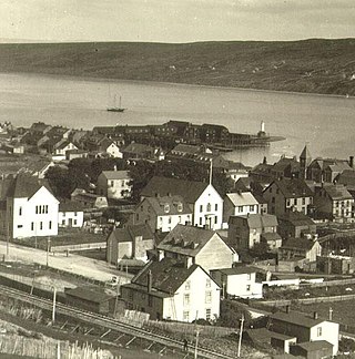
Harbour Grace is a town in Conception Bay on the Avalon Peninsula in the province of Newfoundland and Labrador, Canada. With roots dating back to the 16th century, it is one of the oldest towns in North America.
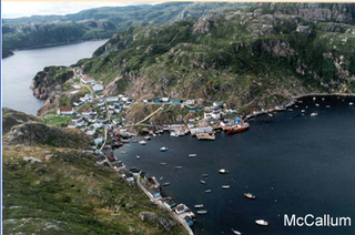
McCallum is a local service district and designated place in the Canadian province of Newfoundland and Labrador. It is on the southern coast of the island of Newfoundland. It is accessible only by boat or by air, and in appearance and way of life is thought by some to be as close to a pre-20th century community as may be found. McCallum lies in an enclosed harbour and is sheltered between two hills. The community survives primarily on the fishery. Whaling was also a major industry in the late 19th century. It is also about an hour and a half from the nearest road, in a community called Hermitage.

Isle aux Morts is a small town on the Southwest Coast of the Island of Newfoundland, with a population of 559 (2021). The town is located approximately 16 km (9.9 mi) east from the Marine Atlantic Ferry Terminal in Port aux Basques along Route 470.
Statistics Canada conducts a national census of population and census of agriculture every five years and releases the data with a two-year lag.
Virgin Arm–Carter's Cove is a local service district and designated place on New World Island in the Canadian province of Newfoundland and Labrador. Virgin Arm-Carter's Cove is located approximately 90 km Northwest of Gander in Subdivision H of Division No. 8.
Rock Harbour is a local service district and designated place in the Canadian province of Newfoundland and Labrador. It is east of Marystown on Placentia Bay.

The 1911 census of Ireland was the last census that covered the whole island of Ireland. Censuses were taken at ten-year intervals from 1821 onwards, but the 1921 census was cancelled due to the Irish War of Independence.

Newfoundland and Labrador is a province of Canada on the country's Atlantic coast in northeastern North America. The province has an area of 405,212 square kilometres and a population in 2023 of 533,710, with approximately 95% of the provincial population residing on the Island of Newfoundland, with more than half of the population residing on the Avalon Peninsula. People from Newfoundland and Labrador are called "Newfoundlanders," "Labradorians", or "Newfoundlanders and Labradorians".
Deadman's Bayis a local service district and designated place in the Canadian province of Newfoundland and Labrador. It is on the Straight Shore of Bonavista Bay near the community of Lumsden. The community is located near fishing grounds, contributing to its diversified and successful fishery despite its exposed, sandy coastline and harsh fall storms.

English Harbour East is a town in the Canadian province of Newfoundland and Labrador. It is located on the northeast side of Fortune Bay. Settled first by the Mi’kmaq of Newfoundland which used land on the "Neck" of the Harbour, they were joined in the early 1800s, by the English Dodge family and by Irishman Thomas Hynes Sr. European fishermen were first brought to the small community by English merchant family of Newman and Co. based in Harbour Breton, the firm of merchant John Gorman, and the Jersey firm of Nicholle and Co. The town had a population of 117 in the Canada 2021 Census.
Harry's Harbour is a local service district and designated place in the Canadian province of Newfoundland and Labrador. It is southeast of Baie Verte.

South East Bight (SEB) or Southeast Bight is a local service district and designated place in the Canadian province of Newfoundland and Labrador. It is on the western shore of Placentia Bay on the Burin Peninsula. The community is not connected by road and is only accessible by ferry from Petite Forte. Many people from the community travel to Monkstown in the winter by snowmobile, but is very uncommon to try to get there in the summer, because of marsh, bogs, ponds and hills. To get to South East Bight one must travel towards Marystown on the Burin Peninsula, turn off the highway at Boat Harbour, travel to Petite Forte and then take a half-hour ferry ride to South East Bight.

Sop's Arm is a local service district and designated place in the Canadian province of Newfoundland and Labrador. The community was formed in the 1930s and 1940s by families moving from surrounding communities, including Jackson's Arm. In the 1950s and 1960s families from nearby Sop's Island moved to Sop's Arm, towing their houses across the channel of water.

Brig Bay is a local service district and designated place in the Canadian province of Newfoundland and Labrador. It was first mapped by Captain James Cook in September 1764. The name "Brig" was adopted by the French who occupied the bay prior to English occupation. It provided a safe and well-sheltered harbour.
New Harbour is a local service district and designated place in the Canadian province of Newfoundland and Labrador. It is on the east shore of Trinity Bay, along Provincial Route 80. Route 80's intersection with Route 73 is inside New Harbour.