Otago is a region of New Zealand located in the southern half of the South Island administered by the Otago Regional Council. It has an area of approximately 32,000 square kilometres (12,000 sq mi), making it the country's second largest local government region. Its population was 246,000 in June 2022.

The Clutha River is the second longest river in New Zealand and the longest in the South Island. It flows south-southeast 338 kilometres (210 mi) through Central and South Otago from Lake Wānaka in the Southern Alps to the Pacific Ocean, 75 kilometres (47 mi) south west of Dunedin. It is the highest volume river in New Zealand, and the swiftest, with a catchment of 21,960 square kilometres (8,480 sq mi), discharging a mean flow of 614 cubic metres per second (21,700 cu ft/s). The river is known for its scenery, gold-rush history, and swift turquoise waters. A river conservation group, the Clutha Mata-Au River Parkway Group, is working to establish a regional river parkway, with a trail, along the entire river corridor.

Dunedin is the second-largest city in the South Island of New Zealand, and the principal city of the Otago region. Its name comes from Dùn Èideann, the Scottish Gaelic name for Edinburgh, the capital of Scotland. The city has a rich Scottish, Chinese and Māori heritage.
Dunedin Railways is the trading name of Dunedin Railways Limited, an operator of a railway line and tourist trains based at Dunedin Railway Station in the South Island of New Zealand. The company is a council-controlled trading organisation wholly owned by Dunedin City Council through its holding company Dunedin City Holdings Limited.

Strath Taieri is a large glacial valley and river plateau in New Zealand's South Island. It is surrounded by the rugged hill ranges to the north and west of Otago Harbour. Since 1989 it has been part of the city of Dunedin. The small town of Middlemarch is located at its southern end.

The Water of Leith, is a small river in the South Island of New Zealand.

Tropical Storm Alberto produced extensive flooding over portions of Alabama, Georgia, and Florida in July 1994. The first tropical cyclone and named storm of the annual hurricane season, Alberto developed from a tropical wave over the northwestern Caribbean Sea on June 30. Initially a tropical depression, the system moved westward, before curving northwestward on July 1 and entering the Gulf of Mexico. Early on the following day, the depression intensified into Tropical Storm Alberto. Alberto strengthened steadily over the Gulf of Mexico, and by midday on July 3, it peaked as a strong tropical storm with maximum sustained winds of 65 mph (100 km/h). A few hours later, the cyclone made landfall near Destin, Florida, at the same intensity. The system quickly weakened to a tropical depression early on July 4. Thereafter, a high pressure system caused Alberto to drift over west-central Georgia and central Alabama, until the storm dissipated over Alabama on July 7.

The 1939 California tropical storm, also known as the 1939 Long Beach tropical storm, and El Cordonazo, was a tropical cyclone that affected Southern California in September 1939. Formerly a hurricane, it was the only tropical storm to make landfall in California in the twentieth century. Fisherman in the villages along the Mexican coast have named these storms, the Lash of St. Francis. The only other known tropical cyclone to directly affect California at tropical storm intensity or higher is the 1858 San Diego hurricane, and only three other eastern Pacific tropical cyclones have produced gale-force winds in the continental United States. The tropical storm caused heavy flooding, leaving many dead, mostly at sea.

Tropical Cyclone Steve was a tropical cyclone that affected northern Australia from 27 February 2000 until 11 March 2000. Cyclone Steve was noted for its longevity and traversal of northern and western Australia. It impacted on regions of northern Queensland, the Northern Territory and Western Australia before clearing to the south of the continent. Steve is the first known Australian cyclone to make four distinct landfalls in the country.

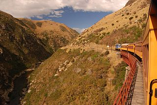
The Otago Central Railway (OCR) or in later years Otago Central Branch Railway, now often referred to as the Taieri Gorge Railway, was a secondary railway line in Central Otago, in the South Island of New Zealand.

The villages and then city that lay at the head of Otago Harbor never existed in isolation, but have always been a staging ground between inland Otago and the wider world. While Dunedin's current official city limits extend north to Waikouaiti, inland to Middlemarch and south to the Taieri River mouth, this articles focus is the history of the Dunedin urban area, only mentioning Mosgiel, the Otago Peninsula, Port Chalmers and inland Otago for context.
Floods in the United States are generally caused by excessive rainfall, excessive snowmelt, and dam failure. Below is a list of flood events that were of significant impact to the country during the 20th century, from 1900 through 1999, inclusive.
Floods in the United States before 1900 is a list of flood events that were of significant impact to the country, before 1900. Floods are generally caused by excessive rainfall, excessive snowmelt, and dam failure.

The climate of New Zealand is varied due to the country's diverse landscape. Most regions of New Zealand belong to the temperate zone with a maritime climate characterised by four distinct seasons. Winters are relatively mild and summers comparatively cool. The main contributing factors are the Pacific Ocean and latitude, although the mountain ranges can cause significant climate variations in locations barely tens of kilometres from each other. Conditions vary from extremely wet on the West Coast of the South Island to almost semi-arid in Central Otago and subtropical in Northland.

The 2010 Victorian storms were a series of storms that passed through much of the Australian state of Victoria on 6 and 7 March 2010. One of the most severe storms passed directly over Greater Melbourne, bringing lightning, flash flooding, very large hail and strong winds to the state's capital.
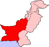
The 2011 Balochistan floods started from the last week of February and continued until the first week of March. Balochistan province was already badly affected from last year's devastating floods as UNHCR claims that 166,000 flood victims are still homeless in the province with 240 people still living in camps.
In June 1947 the southern half of Tasmania was affected by its largest floods on record. Although flooding at its peak between 16 and 18 June affected almost all rivers and streams across the island, in the rest of the state, the flooding did not approach the extent of the better-known 1929 floods. Floods on rivers such as the Derwent and Huon were the largest on record and caused considerable damage.
The 1850 Atlantic hurricane season was the last season excluded from the scope of the official Atlantic hurricane database. Although meteorological records are sparse and generally incomplete, they indicate that three significant tropical cyclones affected land, each causing some degree of damage. The first system struck North Carolina on July 18, causing significant damage before battering the Mid-Atlantic states with high tides, strong winds, and heavy rainfall. Torrential rainfall caused river flooding from Baltimore to Philadelphia, particularly along the Schuylkill River, which took the lives of 20 people in various incidents. Strong winds damaged property and public facilities in and around New York City, and damaging floods extended into central and northern New England. Crops and railroad infrastructure suffered throughout the entire region.

Tropical Depression Eight caused severe flooding in southeastern Texas in late August 1981. The twelfth tropical cyclone of the annual hurricane season, the depression developed from a tropical disturbance over the Bay of Campeche on August 26. Moving northwestward, the cyclone failed to intensify into a tropical storm before making landfall in the Mexican state of Tamaulipas to the north of Tampico on August 28, with winds of 35 mph (55 km/h). After moving inland, the depression curved north-northwestward before degenerating into a surface low pressure area near the Mexico–United States border on August 29. The remnants moved eastward across Texas and entered Louisiana before dissipating on September 1.