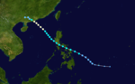
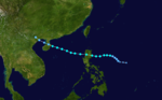
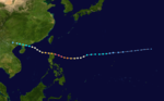
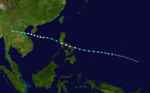
The 1989 Pacific typhoon season was the first of six consecutive years of above-average activity in the Western Pacific. It was an extremely active season spawning 32 tropical storms, 20 typhoons and five super typhoons. It has no official bounds; it ran year-round in 1989, but most tropical cyclones tend to form in the northwestern Pacific Ocean between May and November.[1] These dates conventionally delimit the period of each year when most tropical cyclones form in the northwestern Pacific Ocean. The first storm, Winona, formed on January 15, while the final storm, Jack, dissipated on December 27. This season was also quite a deadly season that were caused by a few notable storms such as Tropical Storm Cecil, which was the worst storm to impact Vietnam in over 50 years,[2] and Typhoon Gay, which directly impacted the Malay Peninsula as the worst typhoon in 35 years. Both of these storms make up around half of the total fatalities of the entire season alone.
The scope of this article is limited to the Pacific Ocean, north of the equator and between 100°E and 180th meridian. Tropical Storms formed in the entire west pacific basin were assigned a name by the Joint Typhoon Warning Center. Tropical depressions in this basin have the "W" suffix added to their number. Tropical depressions that enter or form in the Philippine area of responsibility are assigned a name by the Philippine Atmospheric, Geophysical and Astronomical Services Administration or PAGASA.
Season summary
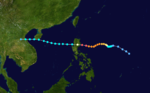
Throughout 1989, several large-scale factors across the western Pacific Ocean displaced unusual characteristics that presented unique difficulties to forecasters. In their annual tropical cyclone report for 1989, the Joint Typhoon Warning Center regarded the season as one of the most challenging and unique years in their history. During much of the year, a very broad monsoon trough was present and resulted in significant diurnal fluctuations in convective activity that inhibited rapid development of many disturbances. The mid-tropospheric ridge was unusually narrow and led to difficulties in forecasting straight-running storms. Additionally, the tropical upper tropospheric trough (TUTT) had a major role in the development of many systems, most notably Typhoon Gordon which formed from a single thunderstorm underneath a TUTT cell.[3]
The season began with the unusual development of Tropical Storm Winona east of the International Date Line in early January. Remaining active for two weeks, the system crossed the basin before dissipating over the Philippines. Following a three-month lull in activity, a powerful typhoon developed in mid-April and was the second system in nine years to become a super typhoon during that month. By mid-May, an extensive monsoon trough had become established from the Bay of Bengal eastward into the South China Sea. Typhoon Brenda developed from this trough over the South China Sea and moved inland over southern China before dissipating. The typhoon left an area of enhanced low-level southerly flow in its wake that triggered the development of Typhoon Cecil at the end of the month. Two more storms developed during June – Typhoon Dot and Tropical Storm Ellis. The first was a strong typhoon that developed near the Caroline Islands and moved westward, eventually dissipating over Vietnam. The second was a poorly organized system that moved generally northward and struck Japan.[3]
In early July, a surge in the monsoon trough over the basin resulted in the development of Tropical Storm Faye. While this system was over the Philippines, Typhoon Gordon developed underneath a TUTT cell to the east. Following Gordon's rapid intensification phase, a new tropical storm developed within an area of enhanced divergence associated with the same TUTT cell. Several days later, the monsoon trough became exceptionally active and spawned several consecutive cyclones in late-July: Irving over the South China Sea, Judy near the Mariana Islands, 12W near Taiwan, and Ken–Lola around the Ryukyu Islands. The development of seven tropical cyclones in July made it the most active July since 1973. The extreme activity continued into August with the formations of Mac, Nancy, Owen, Peggy, and 19W, all of which formed within the monsoon trough. The rapid succession of Nancy, Owen, and Peggy led to several days of binary interaction between the systems well to the south of Japan. Tropical Storm Roger developed near the Ryukyu Islands a few days after 19W dissipated and rapidly tracked northeastward through Japan. This was the only storm of the month not to develop within the monsoon trough. The final system of August, 21W, developed to the northeast of Guam and dissipated due to strong wind shear.[3]
Heavy rains alongside several typhoons between June and September resulted in deadly flooding across parts of Anhui, Hebei, Hubei, Jiangsu, Jiangxi, Jilin, Sichuan, and Zhejiang provinces in China. The floods killed approximately 3,000people and overall losses reached $2.7billion.[4]
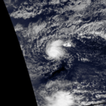
On January15, Tropical Storm Winona crossed the International Date Line and entered the Western Pacific basin. Embedded within broad easterly flow, the storm turned west-southwestward, a heading it would retain until dissipation, and accelerated. This acceleration caused slight strengthening of the storm by enhancing winds on the north side of the low.[5]
On January16, Winona passed approximately 140km (87mi) south of Wake Island. Operationally, it was not until January18 that the JTWC began issuing warnings on the system.[5] At the same time, the JMA assessed Winona to have been a weak tropical storm with winds of 65km/h (40mph).[6] Around 0700UTC on January18, the ship MV Williams passed close to or through the center of Winona and measured a pressure of 991mbar (991hPa; 29.3inHg) alongside 85km/h (55mph) sustained winds with gusts up to 130km/h (80mph). This was the only direct measurement in relation to the cyclone. Early on January19, the JTWC assessed Winona to have reached its peak intensity with 100km/h (60mph) winds as it passed just north of Saipan. Later that day, convection quickly diminished as Winona moved into a shallow air mass-produced by polar system to the north. The system maintained only intermittent convection for another day before making landfall in the central Philippines. The storm quickly weakened and dissipated on January22 as it emerged into the South China Sea.[5]
Before dissipating, the remnants of Winona tracked through the Philippines; however, no known impact resulted from its passage. Throughout its nearly two week existence, Winona traveled approximately 10,185km (6,329mi) across the Pacific Ocean.[5]
Thunderstorm activity increased in coverage near Truk/Chuuk in the Caroline Islands on April 13. The system slowly developed, organizing into a tropical depression on April 18 while moving slowly to the west. On April 19, Andy began to move northward while continuing to intensify. The intense cyclone missed Guam by 130 kilometres (81mi) to the southeast, with winds peaking at 68 knots (126km/h) on Guam. Thereafter, Andy recurved to the northeast and steadily weakened due to increased vertical wind shear out of the west, dissipating as a tropical cyclone on April 24. Andy became the second typhoon to form in April in nine years.[7]
Prior to Typhoon Andy's arrival, 14 B-52s and 3 KC-135s were relocated from Anderson Air Force Base in Guam to Hickam Air Force Base in Hawaii, while one KC-135 was sent to Clark Air Base in the Philippines.[8] Nearly half of the schools in Guam were converted to public shelters.[9] Approximately 1,100 people sought refuge across the island.[9] On April21, the typhoon's close passage brought sustained winds of 130km/h (80mph) and gusts up to 155km/h (95mph) to Guam.[8] The storm's high winds downed many power lines, leaving about 15percent of Guam without power for several hours. Overall damage from the storm was minimal despite the strong winds and no reports of major structural damage or injuries were received.[9] Heavy rain also impact much of the southern Mariana Islands, amounting to about 130mm (5.1in) in Guam. These heavy rains caused pump malfunctions that left many residents without drinkable water.[10]
A tropical depression which formed in the monsoon trough on May 14 became a tropical storm on May 16 and struck Samar Island and southern Luzon in the Philippines that day. At least four ships sank and 50people were killed in the Philippines. Brenda became a typhoon and reached a peak of 85mph (137km/h) winds before hitting southern China on May 20. The storm brought torrential flooding, resulting in at least 84 casualties and widespread damage in China. In Hong Kong six people were killed and one was missing due to landslides and flooding.[11]
On May16, storm warnings were issued for 20provinces across the Philippines as Brenda approached the country. Multiple commercial vessels were kept at port until the storm passed.[12] Throughout the country, Brenda killed at least 18 people and left 6,000 more homeless. Additionally, 52 people were reported missing.[13]
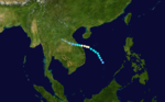
Cecil originated as a tropical depression over the South China Sea on May22.[14] Tracking north-northwestward, the system steadily intensified, attaining peak winds of 110km/h (70mph).[6] The JTWC assessed Cecil to have been slightly stronger with one-minute sustained winds of 140km/h (85mph). The storm made landfall near Hội An late on May24 and quickly weakened. The system later dissipated over Laos on May26.[14] In Vietnam, heavy rains accompanying the storm, amounting to over 510mm (20in) in some areas, triggered catastrophic flooding that killed 751people.[15][16] Widespread structural and agricultural losses took place in addition to the significant loss of life, with damage estimated at ₫300billion ($71.7million).[17][18] In the wake of the flooding, some international aid was sent to Vietnam, though most relief work was conducted by the government, local agencies, and the Red Cross.[19]
Originating from a tropical disturbance near Palau on June4, Dot tracked west-northwestward towards the Philippines. Crossing the country on June6, the system moved over the South China Sea and attained typhoon status. Late on June8, Dot reached its peak intensity with winds estimated at 185km/h (115mph). The system weakened slightly the next day before making landfall in Hainan Island. A weakened storm then entered the Gulf of Tonkin before striking northern Vietnam and dissipating on June12.[20]
Throughout its course, Typhoon Dot produced heavy rains in the Philippines, China and Vietnam, resulting in significant damage and eight fatalities. The most severe impacts took place on Hainan Island where 1,400 homes were destroyed and another 60,000 were damaged.[21] In Vietnam, Dot killed six people and exacerbated flooding triggered in late May by Tropical Storm Cecil.[22]
Developing as a disturbance in the Philippine Sea on June 18, the system moved westward initially and became a tropical depression late on June 20 and weakened on June 21. Early on June 23, the large system with gales well removed from its center became a tropical depression once more. A trough to its northwest had deepened, which was accelerating the cyclone northward. It became a minimal tropical storm during this acceleration. Late that day, it became a frontal wave before moving through Japan into the Sea of Japan.[23]
Tropical Storm Ellis produced rain over much of Japan, with the heaviest falling around Tokyo where rainfall rates reached 53mm (2.1in) per hour. Between June23 and 24, 343mm (13.5in) of rain fell in the city, much of which fell in a 24-hour span. Several areas also recorded tropical storm force winds.[24]
On July6 a tropical depression formed west of Luzon. Tracking generally westward, the system soon strengthened into Tropical Storm Faye. On July8, the storm struck the Philippines as a severe tropical storm before moving into the South China Sea. Struggling to regain strength, the system subsequently made landfall in northern Hainan Island. After briefly emerging into the Gulf of Tonkin, Faye made its third and final landfall near Hai Phong, Vietnam on July11. Once onshore, Faye rapidly dissipated.[25]
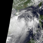
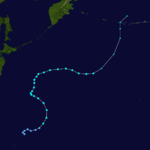
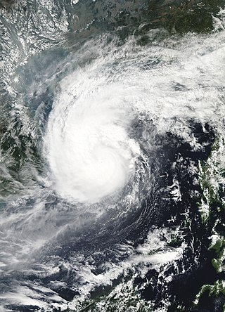
Originating from a single cluster of thunderstorms on July9, Gordon developed into a tropical depression near the Northern Mariana Islands and quickly intensified as it tracked west-southwestward. On July13, the storm attained typhoon status and subsequently underwent a period of rapid intensification. By July15, the storm attained its peak strength as a Category5 equivalent super typhoon with winds estimated at 260km/h (160mph). After striking the northern Philippines, Gordon moved through the South China Sea and slowly weakened. On July18, the storm made landfall in southern China and was last noted the following day as it dissipated over land.[26]
Throughout Gordon's path from the Philippines to China, the storm caused widespread damage and loss of life.[26] Across the Philippines, 90 people were killed by the typhoon and an estimated 120,000 people were left homeless.[27] Though a weaker storm when it struck China, damage was more severe due to extensive flooding. Several coastal cities were completely inundated.[28] Throughout the country, at least 200 people died and losses reached 1.2billion yuan ($319million USD).[29] Additionally, 14 people drowned offshore and 2 others died in Hong Kong.[21][30]
A tropical depression formed in the wake of Super Typhoon Gordon on July 16. The depression moved towards the northwest and strengthened into Tropical Storm Hope. Hope moved approximately 100 miles (160km) south of Okinawa and then strengthened to a peak of 65mph (105km/h) while nearing the China coastline. Due to its proximity to the Philippines, the Philippine Atmospheric, Geophysical and Astronomical Services Administration also monitored the storm and assigned it with the local name Huling.[31] Hope made landfall on the east China coastline on July 21.[32]
Following on the heels of Typhoon Gordon, Hope enhanced monsoonal rainfall over the Philippines, exacerbating ongoing floods and hampering relief efforts. Three fatalities took place after a landslide in Baguio destroyed a home. Although related to Tropical Storm Hope, the deaths were attributed to Typhoon Gordon.[33]
Throughout Zhejiang and Fujian Provinces, Hope killed 198 people, injured more than 1,901 and left $340million in damage. Additionally, 53 people were reported missing.[34][35]
Tropical Storm Irving formed in the South China Sea west of the Philippines on July 21. Although hampered by northerly sheer Irving intensified to a peak of 65mph (105km/h) just before landfall in northern Vietnam.[32]
Striking Vietnam as a strong tropical storm, Irving brought widespread heavy rain that caused damaging floods. Parts of Tinh Gia District received up to 423mm (16.7in) of rain. At least 82,000 homes were destroyed and according to the Vietnamese Army newspaper, Quan Doi Nhan Dan, 10,273 classrooms were also damaged or destroyed by the floods.[36][37] Agricultural losses were also significant with approximately 159,800 hectares (395,000 acres) of crops, including 56,800 hectares (140,000 acres) of rice and 7,900 hectares (20,000 acres) of other products, being inundated by flood waters.[37][38] Throughout the country, 104people were killed due to Tropical Storm Irving's passage.[39]
Originating from a monsoon trough on July21, Judy began as a tropical depression west of the Northern Mariana Islands. Tracking west-northwest, the system gradually intensified into Tropical Storm Judy on July23. By this time, the storm had turned due north. Two days later, Judy attained typhoon status as it began a gradual turn to the west-northwest. Late on July25, the storm peaked with winds of 165km/h (105mph). Striking Kyushu on July27, interaction with the island's mountainous terrain caused Judy to quickly weaken as it neared South Korea. The weakened storm struck the country west of Pusan the following day before losing its identity near the border with North Korea. The remnants of Judy were last noted over the Sea of Japan.[40]
In Japan, damaging winds from the typhoon left approximately 4million people without power.[41] Significant flooding in the country resulted in 11 deaths and $28.9million in damage.[42][43][44] In South Korea, heavy rains from the storm exacerbated ongoing floods, leading to at least 20 fatalities.[45] Flooding from the remnants of Judy affected the Soviet Far East, temporarily severing the Trans-Siberian Railway and killing 15 people.[46]
TD 12W developed out of an active monsoon trough and moved westward for the duration of its existence, never attaining tropical storm status due to high wind shear. After the tropical depression moved over northern Taiwan, The low-level center decoupled from the mid-level center in the Taiwan Strait, and advisories were discontinued.
Between July26 and 30, heavy rains fell across parts of Taiwan, resulting in deadly floods. At least 16 people perished while 2 others were reported missing. Sixty-three homes were destroyed and forty-two others were damaged by the floods. Nearly 1,000 hectares (2,500 acres) of farmland were inundated, resulting in $31.78million in losses. Infrastructural damage across the country amounted to $15.74million. In the wake of the floods, the Government of Taiwan pledged to provide relief funds to those left homeless and family of the deceased.[47]
The monsoon trough spawned a tropical depression on July 29. Poorly organized, it moved quickly northeastward and became a tropical storm on July 30. Operationally, Tropical Storm Ken continued northeastward with the rest of the convection, with Tropical Storm Lola forming further westward, but the ill-defined circulation actually continued westward, leading to one storm with two names. Ken–Lola turned to the southwest, stalling before heading northwest again. Ken–Lola reached a peak of 65mph (105km/h) winds before hitting eastern China on August 3, causing little damage as it slowly dissipated until August 7.[48] Ken–Lola shows the troubles of tracking poorly organized systems. A more recent example is Tropical Depression 32W/33W in 1995.
Heavy rains associated with Tropical Storm Ken–Lola affected much of Japan as it meandered south of the country for several days. In Tokyo, the storm produced 195mm (7.7in) of rain, leading to several mudslides and flash flooding. Areas along the Kanda River were inundated after the river overflowed its banks. At least nine people were killed in and around Tokyo while seventeen others were reported missing.[49]
Striking the Chinese coastline near Shanghai, rains from Tropical Storm Ken–Lola caused the Huangpu River to rise above its warning level; however, no damage was reported.[50]
Moving around the northeast side of Ken–Lola, and then an upper tropospheric cyclone, Mac moved along a wide northwest arc before settling on a north-northwest track into Japan as a typhoon on August 6, dissipating over Sakhalin Island on August 8.[51]
A short lived tropical storm existed near the Northern Mariana Islands in mid-August. Forming on August16, Peggy attained minimal tropical storm status before succumbing to wind shear and dissipating on August18.
On August16, a large area of low pressure centered about 335km (208mi) northwest of Okinawa began to show signs of possible tropical cyclogenesis. Initially, the storm's center was mostly cloud-free as subsidence from the mid-level low suppressed convective activity. Later on August16, however, strong divergence moved into the region and allowed for showers and thunderstorms to form. Subsequently, the JTWC issued a Tropical Cyclone Formation Alert and later issued the first advisory on Tropical Depression 19W early on August17.
A tropical disturbance began to organize just to the north of Taiwan while moving eastwards. The disturbance consolidated to a depression on August 24 and was named Tropical Storm Roger the next day. Roger then abruptly turned towards the northeast and accelerated. Roger reached peak intensity of 60mph (97km/h) just before landfall at Cape Muroto on Shikoku Island.[32]
Tropical Storm Roger produced significant rainfall across the majority of Japan, affecting areas from the Ryukyu Islands to Hokkaido. The heaviest rains fell over the Kii Peninsula and Shikoku, with 505 and 464mm (19.9 and 18.3in) measured in Hidegadake, Nara and Kubokawa, Kōchi respectively.[52] These rains triggered widespread flooding that killed at least three people.[53] In Osaka, a train derailed and crashed into a buffer, resulting in 50 injuries. It is unknown if the accident was the result of Roger, though many trains at the time were cancelled due to flooding.[54] At least 1,071 homes were flooded across the country and numerous roads were washed out.[55]
On August23, a tropical depression formed well to the north-northeast of Guam. Tracking northeast, the depression struggled to intensify amidst wind shear. According to the JMA, the system attained tropical storm intensity on August26. By August27, the storm weakened due to persistent shear and later dissipated on August29.
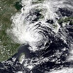
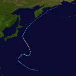
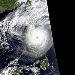
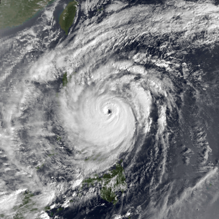
Originating from a disturbance within a monsoon trough in early September, Sarah was first classified as a tropical depression near the Mariana Islands on September5. Moving quickly westward, the depression soon strengthened into Tropical Storm Sarah. On September8, the storm abruptly turned southward and temporarily attained typhoon status. Following a series of interactions with secondary areas of low pressure, the storm turned northward the following day. By September11, Sarah entered a region favoring development and underwent a period of explosive intensification. At the end of this phase, the storm attained its peak intensity as a Category4-equivalent typhoon on the Saffir–Simpson hurricane scale. The typhoon subsequently weakened rapidly and made two landfalls in Taiwan by September12. After moving over the Taiwan Strait, Sarah made its final landfall in eastern China on September13 before dissipating the following day.[56]
While the typhoon meandered near the Philippines, it brought several days of heavy rain to much of Luzon, triggering extensive flash flooding. At least 44 people perished across the country and another 200,000 were left homeless.[27] Striking Taiwan as a strong typhoon, Sarah caused widespread wind damage that left approximately 840,000residents without power.[57] Excessive rainfall associated with the storm triggered flooding that washed away highways and inundated about 40,500 hectares (100,000 acres) of farmland.[58] Throughout the island, Sarah was responsible for 19 fatalities and at least US$171million (4.38billion New Taiwan dollars) in damage.[21][59] Four deaths also took place on the Gotō Islands.[60] Additionally, four deaths took place offshore and another seventeen people were listed as missing.[21][61]
Tip formed along the eastern portion of the monsoon trough, and tracked northeast until the subtropical ridge blocked its motion in that direction. Rounding the western periphery of the ridge, Tip eventually recurved well offshore Japan and became an extratropical cyclone.[62]
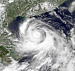
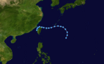
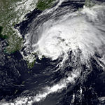
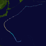
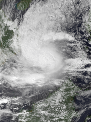
On September10, an area of low-level convergence developed within a monsoon trough several hundred kilometres north of Guam. Following the development of persistent convection, the JTWC issued a TCFA early on September11 before classifying it as a tropical depression 26hours later. Initially, the system moved slowly and erratically before being steered west-northwest by a subtropical ridge. Shortly after being declared a depression, the system intensified into Tropical Storm Vera. Only modest strengthening took place thereafter, with the system attaining peak winds of 95km/h (60mph). Accelerating towards China, Vera gradually weakened due to increasing wind shear. After passing 185km (115mi) south of Okinawa on September14, the storm made landfall about 240km (150mi) south of Shanghai the next day. Once onshore, Vera weakened to a tropical depression as it turned northward.[63] The remnants of Vera later transitioned into an extratropical cyclone on September16 as it emerged over the Yellow Sea. The system tracked east-northeast for several days, passing over South Korea and northern Japan before moving over north Pacific Ocean. Vera was last noted as a powerful system near the International Date Line on September19 with a central pressure of 964 mbar (hPa; 28.47inHg).[6]
Although only a tropical storm at landfall, torrential rains associated with Vera triggered widespread flooding throughout eastern China.[64] Damage from the storm was regarded as the worst in 27years.[65] Large parts of Zhejiang Province were inundated by the storm, including the port city of Shujiang. Early reports indicated that at least 190 people were injured near Shanghai.[64] Two days after the storm, only scarce reports on the scale of damage were available. On September18, officials announced over national television that at least 72 people were killed and hundreds were missing. By then, workers began repairing damaged coastlines and building up stone sea walls.[66] According to the nation's flood control officials, approximately 347,000 hectares (860,000 acres) of farmland and 16,000 hectares (40,000 acres) of crops were flooded by the storm. At least 162 people were killed and another 354 were listed as missing. Additionally, 692 people were injured by the storm.[67] Immense structural losses took place throughout the province with 3.1million homes damaged or destroyed. Additionally, 430km (270mi) of coastal dykes and 174km (108mi) of irrigation ditches were washed away.[68] Total losses throughout Zhejiang Province reached $351million.[67] Significant losses also took place in nearby Jiangsu Province where 34 people were killed and an estimated 2,000 more were injured. Approximately 590,000hectares (1.5millionacres) of farmland was inundated by the storm and total losses reached $485,000.[68] Throughout eastern China, approximately 5.86million households (23million people) were affected by flooding triggered by the storm.[69] According to the news estimates, a total of 500–700people died as a result of Vera.[63]
Typhoon Wayne formed from a depression on September 17 about 100 miles (160km) southwest of Okinawa. Tropical Storm Wayne was named the next day and into a typhoon on September 19. Wayne reached peak intensity of 75mph (121km/h) before beginning to accelerate toward the northeast. Typhoon Wayne skimmed the southeastern island of Japan while weakening into a tropical storm.[32]
Throughout Japan, Wayne produced rainfall in excess of 200mm (7.9in), peaking at 313mm (12.3in), that triggered flash flooding and mudslides. In parts of Kōchi Prefecture, rainfall rates reached 83mm (3.3in) per hour.[70] According to Japanese Police, the storm caused 166 mudslides and affected 33 of the country's 49 prefectures.[71] Eight people were killed by the storm,[70] including three children who drowned after falling into a swollen river.[72] A total of 247 homes were destroyed and another 5,824 were damaged.[70]
The first in a series of tropical cyclones to develop within the monsoon trough, Angela was first identified as a tropical depression on September28. Initially, a shortwave trough caused the system to move north-northwest; however, once this feature moved away from Angela, the cyclone acquired a general westward track. Developing dual outflow channels on October1, Angela rapidly intensified into a Category4 equivalent typhoon. After maintaining its strength for four days, the storm intensified into a super typhoon on October5 with peak winds estimated at 240km/h (150mph).[73] At this time, the JMA assessed Angela to have attained ten-minute winds of 175km/h (110mph) and a minimum pressure of 925 mbar (hPa; 27.32inHg).[74] Later that day, the storm skirted the northern coast of Luzon before moving into the South China Sea. Considerable weakening took place due to the interaction with the Philippines and the system was slow to re-organize. In response to a ridge over China, Angela turned to the west-southwest. On October9, the storm brushed the southern coast of Hainan Island before making landfall near Huế, Vietnam. Once onshore, Angela rapidly dissipated and was last noted during the afternoon of October10.[73]
Throughout northern Luzon, high winds and heavy rains from the typhoon destroyed 14,064 homes and damaged 19,245 more. Angela was the deadliest in the series of storms to strike the Philippines with 119 fatalities; another 28 people were reported missing.[27] Total economic losses from the storm reached $8million.[75] Significant damage took place on Hainan Island and in Vietnam but specifics are unknown due to the rapid succession of storms.[21][76]
Originating from an area of low pressure associated with a monsoon trough in late-September, Brian quickly organized into a tropical storm over the South China Sea. Tracking along a general west-southwest to westerly course, the storm attained typhoon status on October1 before making landfall along the southern coast of Hainan Island the following day. After briefly crossing land, the storm moved into the Gulf of Tonkin and ultimately struck Vietnam on October3 before dissipating the next day over Laos.[77]
Across Hainan Island, Brian caused extensive damage to property and infrastructure. Nearly 185,000homes were damaged or destroyed by the storm's high winds or flash flooding. Communications were severely disrupted as 2,800km (1,700mi) of power and telephone lines were downed. Brian killed 40 people and inflicted 837million Renminbi (US$222million) in damage throughout Hainan before striking Vietnam and causing further damage.[21] Significant losses were reported in Vietnam as well; however, the rapid succession of Brian and two other typhoons made it difficult to differentiate the losses caused by each storm.[76]
On October2, a tropical storm warning was issued for Guam and the Northern Mariana Islands as Colleen approached.[78] As a precautionary measure, U.S. military installations relocated aircraft to Japan and sent ships to sea to ride out the storm.[79]
The second of three typhoons to strike Vietnam in October, Dan developed on October6, and tracked generally westward throughout its course. Initially, intensification was somewhat limited due to its proximity to Typhoon Angela; however, by October9 conditions became more favorable and Dan attained typhoon status.[80] After crossing the Philippines, the typhoon emerged into the South China Sea and reached its peak intensity, with sustained 10-minute winds of 140km/h (85mph) and a minimum barometric pressure of 960 mbar (hPa; 28.35inHg).[74] After brushing the southern coast of Hainan Island, a weakened Dan made landfall in northern Vietnam before dissipating on October13.[80]
The storm caused extensive damage throughout its course. In the Philippines, Dan left more than 232,000 homeless and killed 58 people.[27][80] Though not the strongest in the series of typhoons to affect the Philippines, Dan was the costliest with total economic losses reaching $59.2million.[75] Roughly 95percent of Metro Manila was left without power and some areas remained in the dark for weeks.[80] Across Vietnam, heavy rains from Dan exacerbated ongoing floods and caused further damage to areas recovering from Typhoons Angela and Brian.[76] Approximately 130,000 hectares (320,000 acres) of land was flooded by the storm.[80]
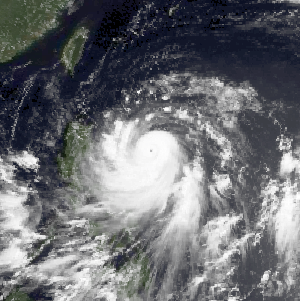
A powerful Category5 super typhoon, Elsie formed out of a tropical disturbance on October13, and initially moved relatively slowly in an area of weak steering currents. On October15, the storm underwent a period of rapid intensification, attaining an intensity that corresponds to a Category 3 hurricane on the Saffir–Simpson hurricane scale. After taking a due west track towards the northern Philippines, the storm intensified further, becoming a Category 5 super typhoon hours before making landfall in Luzon. After moving inland, the typhoon rapidly weakened to a tropical storm. Once back over water in the South China Sea, wind shear prevented re-intensification. Elsie eventually made landfall in Vietnam on October22 and dissipated the following day over Laos.[81]
In the Philippines, Elsie worsened the situation already left in the wakes of typhoons Angela and Dan. Although it was stronger than the previous two, Elsie caused far less damage due to the relatively sparse population in the area of landfall. During the storm's passage, 47 people were killed and another 363 were injured. Damages throughout the country amounted to $35.4million and roughly 332,000 people were left homeless.[27][75]
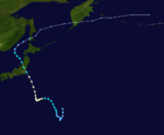
The last of the tropical cyclones in October and the 17th typhoon of the year, Forrest was slow to develop initially near the Marshall Islands as it was a large cyclone. Once it passed Guam by only 85mi (137km), it intensified into a typhoon, with maximum sustained winds peaking at 95 knots (109mph). Tree limbs and power lines were downed as the system pulled away from Saipan. It then recurved, accelerating northeast to become of the strongest extratropical cyclones in the Pacific Ocean that year.[82]
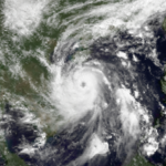
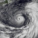
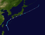
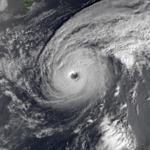
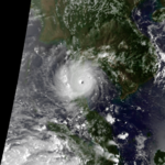
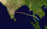
Typhoon Gay, also known as the Kavali Cyclone of 1989,[83] was a small but powerful tropical cyclone which caused more than 800 fatalities in and around the Gulf of Thailand in November 1989. The worst typhoon to affect the Malay Peninsula in thirty-five years, Gay originated from a monsoon trough over the Gulf of Thailand in early November. Owing to favorable atmospheric conditions, the storm rapidly intensified, attaining winds over 120km/h (75mph) by 3November.[nb 1] Later that day, Gay became the first typhoon since 1891 to make landfall in Thailand, striking Chumphon Province with winds of 185km/h (115mph). The small storm emerged into the Bay of Bengal and gradually reorganized over the following days as it approached southeastern India. On 8November, Gay attained its peak intensity as a Category5-equivalent cyclone with winds of 260km/h (160mph). The cyclone then moved ashore near Kavali, Andhra Pradesh. Rapid weakening ensued inland, and Gay dissipated over Maharashtra early on 10 November.
The typhoon's rapid development took hundreds of vessels by surprise, leading to 275 offshore fatalities. Of these, 91 occurred after an oil drilling ship, the Seacrest, capsized amid 6–11m (20–36ft) swells. Across the Malay Peninsula, 588 people died from various storm-related incidents. Several towns in coastal Chumphon were destroyed. Losses throughout Thailand totaled ฿11billion (US $497million).[nb 2] Striking India as a powerful cyclone, Gay damaged or destroyed about 20,000 homes in Andhra Pradesh, leaving 100,000 people homeless. In that country, 69 deaths and ₹410million (US $25.3million) in damage were attributed to Gay.
A tropical disturbance began to organize and a tropical depression formed east of the Philippines on November 16. As the depression moved towards the northwest it strengthened into Tropical Storm Hunt which rapidly intensified becoming a typhoon while moving towards the northwest. Typhoon Hunt reached peak intensity of 105mph (169km/h) just before turning due west towards the Philippines. Hunt maintained peak intensity until landfall on central Luzon Island. Sevenpeople were killed and minor damage occurred to U.S. Military operations. After departing the Philippines Hunt was downgraded and dissipated in the South China Sea.[32]
Offshore, large swells produced by the storm sank a boat off the coast of Quezon Province, killing six people.[84] These waves also swept away 60 homes in the coastal communities of Catarman and Biri, leaving 948 people homeless.[85] A total of 212homes were destroyed and 3,401more were damaged. Overall, 11 people were killed in the Philippines and damage reached 8million pesos (US$350,000).[27] Additionally, approximately 1,500people were left homeless.[85]
Typhoon Irma formed on November 21 as a minimal cyclone. Irma did not intensify at first, as it moved over lukewarm waters for most of its early life. But as it moved over warm waters, it rapidly intensified to a strong typhoon. The storm intensified from a category 1 to a category 3 in less than 2+1⁄2 days, and rapidly intensified from a Category 3 to a Category 5 in 12 hours. Then, Irma began to weaken as it traveled over very cool waters near the Philippines. Irma then weakened and dissipated two days later on December 4.
On December25, a level two tropical cyclone condition of readiness was issued for Guam as Typhoon Jack stalled about 320km (200mi) east of the territory.[86] On December26, several B-52s were relocated from Anderson Air Force Base to Okinawa and the United States Navy ordered vessels to ride out the storm at sea. Banks across Guam were also closed that day and officials in Saipan advised residents to stock up on emergency supplies.[87] Following the storm's dramatic weakening on December27, it was no longer deemed a major threat to the region.[88]
Other systems
In addition to the storms listed above, the China Meteorological Agency also monitored seven other tropical depressions.
In late January, heavy rains affected much of Samar Island, resulting in widespread flooding. In some areas, flood waters reached depths of 1.2m (3.9ft).[90] At least 35 people died as a result of the floods and agricultural losses were estimated at $5million.[91] The flooding was soon worsened as several days of monsoonal rains followed in early February. By February7, at least 61 people had been killed and many more were reported missing.[92]
During the season 32 named tropical cyclones developed in the Western Pacific and were named by the Joint Typhoon Warning Center, when it was determined that they had become tropical storms. These names were contributed to a revised list which started on 1979. However the JTWC changed their naming list during half-way of 1989, starting with the name Angela.
Winona
Andy
Brenda
Cecil
Dot
Ellis
Faye
Gordon
Hope
Irving
Judy
Ken
Lola
Mac
Nancy
Owen
Peggy
Roger
Sarah
Tip
Vera
Wayne
Angela
Brian
Colleen
Dan
Elsie
Forrest
Gay
Hunt
Irma
Jack
Philippines
Atring
Bining
Kuring
Daling
Elang
Goring
Huling
Ibiang
Luming
Miling
Narsing
Openg
Pining
Rubing
Saling
Tasing
Unsing
Walding
Yeyeng
Auxiliary list
Anding(unused)
Binang(unused)
Kadiang(unused)
Dinang(unused)
Epang(unused)
Gundang(unused)
The Philippine Atmospheric, Geophysical and Astronomical Services Administration uses its own naming scheme for tropical cyclones in their area of responsibility. PAGASA assigns names to tropical depressions that form within their area of responsibility and any tropical cyclone that might move into their area of responsibility. Should the list of names for a given year prove to be insufficient, names are taken from an auxiliary list, the first 6 of which are published each year before the season starts. Names not retired from this list will be used again in the 1993 season. This is the same list used for the 1985 season. PAGASA uses its own naming scheme that starts in the Filipino alphabet, with names of Filipino female names ending with "ng" (A, B, K, D, etc.). Names that were not assigned/going to use are marked in gray.
Season effects
This is a table of all of the storms that have formed in the 1989 Pacific typhoon season. It includes their duration, names, affected areas, damages, and death totals. Deaths in parentheses are additional and indirect (an example of an indirect death would be a traffic accident), but were still related to that storm. Damage and deaths include totals while the storm was extratropical, a wave, or a low, and all of the damage figures are in 1989 USD. Names listed in parentheses were assigned by PAGASA.
↑ All sustained wind speeds are based on one-minute standards unless otherwise stated.
↑ All damage figures in the article are in 1989 United States dollars (USD) unless otherwise stated.
Related Research Articles
The 2003 Pacific typhoon season was a slightly below average yearlong period of tropical cyclogenesis exhibiting the development of 45 tropical depressions, of which 21 became named storms; of those, 14 became typhoons. Though every month with the exception of February and March featured tropical activity, most storms developed from May through October. During the season, tropical cyclones affected the Philippines, Japan, China, the Korean Peninsula, Indochina, and various islands in the western Pacific.
The 2002 Pacific typhoon season was a slightly above average Pacific typhoon season, producing twenty-six named storms, fifteen becoming typhoons, and eight super typhoons. It had an ACE over 400 units, making it one of the most active seasons worldwide. It was an event in the annual cycle of tropical cyclone formation, in which tropical cyclones form in the western Pacific Ocean. The season ran throughout 2002, though most tropical cyclones typically develop between May and October. The season's first named storm, Tapah, developed on January 11, while the season's last named storm, Pongsona, dissipated on December 11. The season's first typhoon, Mitag, reached typhoon status on March 1, and became the first super typhoon of the year four days later.
Typhoon Babs, known in the Philippines as Typhoon Loleng, was a powerful typhoon that struck the Philippines days after Typhoon Zeb hit the same area. The seventh typhoon of the inactive 1998 Pacific typhoon season, Babs formed on October 14 between the Philippines and Guam. The storm moved westward initially, failing to intensify initially due to the outflow from Typhoon Zeb to the northwest. Babs slowed and briefly turned to the south before advancing to the northwest, whereupon it rapidly intensified into a strong typhoon. On October 20, the official Japan Meteorological Agency (JMA) estimated peak 10‑minute winds of 155 km/h (96 mph), while the unofficial Joint Typhoon Warning Center (JTWC) estimated peak 1‑minute winds of 250 km/h (160 mph), making Babs an unofficial super typhoon. The storm struck the Philippine island of Catanduanes at that intensity and weakened slightly before hitting Luzon. Babs turned northward once in the South China Sea, later weakening due to unfavorable conditions and transitioning into an extratropical cyclone on October 27 in the Taiwan Strait.
Severe Tropical Storm Kammuri, known in the Philippines as Tropical Storm Lagalag, killed hundreds of people in the wake of a deadly flood season in China. The system developed from a large monsoonal system that persisted toward the end of July 2002 near the Philippines. On August 2, a tropical depression formed off the northwest coast of Luzon and moved west-northwestward. Late on August 3, it intensified into Tropical Storm Kammuri off the coast of Hong Kong. A weakening ridge turned the storm northward toward the coast of China. The storm made landfall with late on August 4, after reaching peak winds of 100 km/h (65 mph). The system dissipated over the mountainous coastline of eastern China and merged with a cold front on August 7.
Typhoon Alex, known in the Philippines as Typhoon Etang, affected the Taiwan, China, and South Korea during July 1987. Typhoon Alex developed from the monsoon trough that spawned a tropical disturbance late on July 21 southwest of Guam which organized into a tropical depression shortly thereafter. The system steadily became better organized, and the next day, a tropical depression had developed. Satellite intensity estimates gradually increased, and on July 23, the depression intensified into Tropical Storm Alex. After initially tracking west-northwest, Tropical Storm Alex started tracking northwest. An eye developed on July 24, and on the next day, Alex was classified as a typhoon, when Alex attained its peak intensity of 120 km/h (75 mph) and a minimum barometric pressure of 970 mbar (29 inHg). Alex weakened while tracking more northward, though interaction with Taiwan resulted in a more westward track starting on July 27. The storm struck near Shanghai as a tropical storm, and weakened over land, although it remained identifiable through August 2.
Typhoon Amy, known in the Philippines as Typhoon Gening, was the second typhoon to strike China in a week during mid-July 1991. An area of convection was first observed on July 13 within the vicinity of Yap. A tropical depression developed the next day. While initially tracking westward, the system slowly deepened, becoming Tropical Storm Amy on July 16. After briefly turning northwestward, Amy intensified into a typhoon on July 17. Continuing to intensify as it tracked through the Luzon Strait, Amy reached its peak intensity of 175 km/h (110 mph) on July 18. That evening, the typhoon began to show signs of weakening, although it was still believed to have been a typhoon when it made landfall in the province of Guangdong on July 19, becoming the strongest tropical cyclone to hit the province in 22 years. Once inland, the storm rapidly weakened, and by late on July 20, had dissipated completely.
Typhoon Cecil, known in the Philippines as Tropical Storm Rubing, was one of two typhoons to strike Vietnam within a week in 1985. Cecil originated from an area of convection that tracked west-northwest and passed south of Palau late on October 9. The disturbance became increasingly defined as it moved through the southern Philippines. On October 12, a tropical depression developed, and the next day, the depression was upgraded into a tropical storm. Cecil turned northwest over the open waters of the South China Sea as it steadily strengthened, and was classified as a typhoon on October 14. After unexpectedly slowing down, Cecil continued to intensify and at noon of October 14, reached its peak intensity of 145 km/h (90 mph). Land interaction with Vietnam triggered a weakening trend. After turning west, Cecil moved onshore just north of Huế at 22:00 UTC on October 15. After tracking into Laos, the typhoon dissipated 39 hours later.
Typhoon Clara, known in the Philippines as Typhoon Rubing, left flooding in the northern Philippines and southern China during September 1981. An area of disturbed weather was first detected on September 11 near Ponape. After moving westward, the system gradually became better organized and thunderstorm activity increased. On September 16, the system attained tropical storm status. Two days later, Clara attained typhoon intensity and subsequently began to deepen at a faster rate. On September 19, Clara reached maximum intensity, before making landfall along the northern tip of Luzon. Clara steadily weakened after interacting with land, but by late on September 20, Clara leveled off in intensity over the South China Sea. The next day, Clara moved ashore to the east-northeast of Hong Kong while still at typhoon intensity before rapidly dissipating over land.
Typhoon Gordon, known in the Philippines as Typhoon Goring, was a powerful tropical cyclone that caused widespread damage and loss of life in the Philippines and Southern China in July 1989. Gordon developed into a tropical depression near the Northern Mariana Islands on July 9 and quickly intensified as it tracked west-southwestward. On July 13, the storm attained typhoon status and subsequently underwent a period of rapid intensification. By July 15, the storm attained its peak strength as a Category 5 equivalent super typhoon with winds estimated at 260 km/h (160 mph). After striking the northern Philippines, Gordon moved through the South China Sea and slowly weakened. On July 18, the storm made landfall in southern China and was last noted the following day as it dissipated over land.
Typhoon Rammasun, known in the Philippines as Typhoon Florita, was the first of four typhoons to contribute to heavy rainfall and deadly flooding in the Philippines in July 2002. The fifth tropical cyclone of the 2002 Pacific typhoon season, Rammasun developed around the same time as Typhoon Chataan, only further to the west. The storm tracked northwestward toward Taiwan, and on July 2 it attained its peak intensity with winds of 155 km/h (96 mph). Rammasun turned northward, passing east of Taiwan and China. In Taiwan, the outer rainbands dropped rainfall that alleviated drought conditions. In China, the rainfall occurred after previously wet conditions, resulting in additional flooding, although damage was less than expected; there was about $85 million in crop and fishery damage in one province.
Typhoon Nepartak, known in the Philippines as Typhoon Weng, was a modest tropical cyclone that struck the central Philippines and the southern China island of Hainan in November 2003. Forming as a tropical depression on November 11 between Yap and Guam, the system moved westward and slowly intensified. It received the name Nepartak midday on November 12 from the Japan Meteorological Agency, becoming the 20th named storm of the 2003 Pacific typhoon season. On November 13, Napartak struck Samar in the Philippines and bisected the island chain. Up to four million people lost power, and transportation ground to a halt; over 5,000 individuals became stranded on ships forced to stay in port during the tropical storm. It was reported that 13 individuals died in the storm in the Philippines.
Severe Tropical Storm Tess known in the Philippines as Tropical Storm Welpring was the second of three tropical cyclones to directly impact the Philippines in a two-week time frame in 1988. An area of disturbed weather near the Philippines was first observed on November 1. Following an increase in organization, the disturbance was designated as a tropical cyclone on November 4. Moving west, Tess steadily strengthened due to favorable conditions aloft. During the evening of November 5, Tess was estimated to have achieved its highest intensity, with winds of 115 km/h (70 mph). Rapid weakening then ensured as Tess neared Vietnam, and after making landfall in the country on November 6, Tess dissipated the next day.
Typhoon Kim, known in the Philippines as Typhoon Osang, was the second typhoon in a week to directly affect the Philippines during July 1980. Like Typhoon Joe, Kim formed from the near equatorial monsoon trough in the northwestern Pacific Ocean on July 19. The disturbance tracked quickly westward-northwest underneath a subtropical ridge, reaching tropical storm strength on the July 21 and typhoon strength on July 23. After developing an eye, Kim began to rapidly intensify, and during the afternoon of July 24, peaked in intensity as a super typhoon. Several hours later, Kim made landfall over the Philippines, but the storm had weakened considerably by this time. Throughout the Philippines, 40 people were killed, 2 via drownings, and 19,000 others were directly affected. A total of 12,000 homes were destroyed and 5,000 villages were flooded. Less than a week earlier, the same areas were affected by Joe; however, Kim was considered the more damaging of the two typhoons. Land interaction took its toll on Kim, and upon entering the South China Sea, the storm was down below typhoon intensity. Kim continued northwestward but its disrupted circulation prevented re-intensification, and it remained a tropical storm until hitting southern China July 27 to the northeast of Hong Kong, where only slight damage was reported. Later that day, Kim dissipated.
Typhoon Cary, known as Typhoon Ising in the Philippines, was the second of two tropical cyclones to affect Vietnam in a week. An area of disturbed weather developed southwest of Pohnpei on August 6, 1987. The system initially remained disorganized, but by August 14, Cary had attained tropical storm intensity. After initially moving north-northwest, Cary turned west-northwest, although intensification was slow to occur. On August 15, Cary was upgraded into a typhoon, and on August 17, the typhoon peaked in intensity. Typhoon Cary then made landfall in northern Luzon while at peak intensity. Across the Philippines, 954 houses were damaged and an additional 89 were destroyed, which left 55,567 people, or 13,247 families that were either homeless or otherwise sought shelter. Five people died in the country while damage totaled $5.58 million (1987 USD), including $1.45 million from agriculture and $4.13 million from infrastructure. The storm weakened over land, but re-intensified into a typhoon over the South China Sea. On August 21, Typhoon Cary passed just south of Hainan, where hundreds of homes were damaged but no fatalities occurred, and subsequently entered the Gulf of Tonkin. The storm weakened as it approached Vietnam, and on August 23, the storm dissipated inland over Laos. Across Vietnam, almost 40,000 ha of land were flooded or destroyed. Twenty people were killed and many others were injured.
Typhoon Joe, known in the Philippines as Typhoon Nitang, affected the Philippines, China, and Vietnam during July 1980. An area of disturbed weather formed near the Caroline Islands on July 14. Shower activity gradually became better organized, and two days later, the system was upgraded into a tropical depression. On July 18, the depression was classified as Tropical Storm Joe. Initially, Joe moved northwest, but began to turn to the west-northwest, anchored by a subtropical ridge to its north. Joe started to deepen at a faster clip, and attained typhoon intensity on July 19. The eye began to clear out, and the next day, Joe reached its highest intensity. Shortly thereafter, Joe moved ashore the Philippines. There, 31 people were killed and 300,000 others were directly affected. Around 5,000 homes were destroyed, resulting in an additional 29,000 homeless. Damage in the nation was estimated at $14.5 million (1980 USD).
Typhoon Betty, known in the Philippines as Typhoon Aring, was the strongest typhoon to strike the Philippines in ten years. An area of disturbed weather developed on October 27, 1980, near Truk Atoll. After turning east from south, the disturbance was classified as a tropical storm on October 29 as it passed near Guam, causing only minor damage. Following a turn to the west-northwest, Betty attained typhoon intensity the next day. On November 4, Betty peaked in intensity. Later that day, Betty moved ashore over Luzon, introducing a rapid weakening trend. Over land, Betty then began to turn north due to a weakening subtropical ridge to its north and a trough offshore Taiwan. By November 8, Betty, after moving offshore, had completed its transition into an extratropical cyclone, and dissipated that same day.
Typhoon Faith, known in the Philippines as Typhoon Norming, struck both the Philippines and Vietnam during December 1998. A tropical disturbance developed within the vicinity of the western Caroline Islands during early December. At midday on December 8, the system developed into a tropical depression. Tracking northwest at a brisk pace, the depression gradually intensified, and was upgraded into a tropical storm at noon on December 9. Quickly intensifying, Faith turned to the west-northwest, and after tracking near Samar Island on the evening of December 10, Faith attained typhoon intensity. After clipping the northern tip of Palawan Island, the typhoon entered the South China Sea at peak intensity. Across the Philippines, 33 people were killed, with 30 others wounded and 36 others listed missing. A total of 6,423 homes were damaged and 3,234 houses were destroyed, leaving more than 20,000 homeless. Damage was estimated at $25.9 million, with $6.82 million from crops, $15.9 million from public infrastructure, and $3.37 million from private infrastructure.
Typhoon Warren, known in the Philippines as Typhoon Huaning, struck the Philippines and China during July 1988. An area of disturbed weather developed within the vicinity of the Caroline Islands during the second week of July. A tropical depression developed southeast of Guam on July 12, and on the next day, intensified into a tropical storm. Tracking generally west-northwest, Warren deepened into a typhoon on July 14. The storm subsequently entered a period of rapid intensification, commencing with Warren reaching its highest intensity on July 16. The following evening, the typhoon brushed Luzon, resulting in a weakening trend, although Warren was still a typhoon when it made landfall near Shantou. Warren rapidly dissipated inland.
Typhoon Eli, known in the Philippines as Typhoon Konsing, struck the Philippines and Hainan during mid-July 1992. A weak low pressure system developed in the Philippine Sea on July 7, which became a tropical depression on the next day. The depression tracked west-northwest and strengthened into a tropical storm on July 10. After turning more westward, Eli steadily intensified, and obtained typhoon intensity that evening. The storm attained its highest intensity of 130 km/h (80 mph) early on July 11 before striking northern Luzon. After entering the South China Sea, the storm maintained most of its intensity as it approached Hainan, although agencies disagree on how precisely strong it was. After passing through Hainan late on July 13, Eli passed through the Gulf of Tonkin on the next day before striking Vietnam, where Eli quickly dissipated.
Tropical Storm Vera, known in the Philippines as Severe Tropical Storm Pining, originated from a system that began to develop within a monsoon trough several hundred kilometers north of Guam on September 10. The JTWC issued a TCFA early on September 11, and the system was classified as a tropical depression later that day. The depression moved slowly and erratically at first, but then it was steered west-northwest by a subtropical ridge. It strengthened into a tropical storm, being named Vera, and reached its peak intensity with winds of 95 km/h. The storm then weakened due to increasing wind shear and made landfall in China. It weakened further and became an extratropical cyclone on September 16. The remnants of the storm moved east-northeast over South Korea and Japan before dissipating on September 19.
↑ "Worst Natural Disaster". Bangkok, Thailand: New Straits Times. Reuters. June 1, 1989. p.15F. Retrieved March 2, 2013.
1 2 3 Joint Typhoon Warning Center (1990). Western North Pacific Tropical Cyclones(PDF) (1989 Annual Tropical Cyclone Report). United States Navy. pp.22–26. Archived from the original(PDF) on February 21, 2013. Retrieved June 13, 2012.
↑ "Toll from summer rains climbs to 1,400 in China". The Toronto Star. Beijing, China. Reuters. July 19, 1989. p.A19.–viaLexisNexis (subscription required)
↑ "Typhoon Lola to Hit Shanghai". Shanghai, China. Xinhua General News. August 3, 1989.–viaLexisNexis (subscription required)
↑ "14 Fishermen Perish". Palm Peach Post. Hong Kong. August 12, 1989. p.6A.–viaLexisNexis (subscription required)
↑ "Typhoon Huling Spotted". The Manila Chronicle. Manila, Philippines. Xinhua General News. July 18, 1989. (accessed through LexisNexis)
1 2 3 4 5 Joint Typhoon Warning Center. "Archived copy"(PDF). Archived from the original(PDF) on 2011-06-07. Retrieved 2010-01-26.{{cite web}}: CS1 maint: archived copy as title (link) Retrieved on 2007-12-26.
↑ "Rains, Flooding Kill 197 in China". Beijing, China. Associated Press. July 26, 1989.–viaLexisNexis (subscription required)
↑ "Storms kill 200 in eastern China". Beijing, China. United Press International. July 26, 1989.–viaLexisNexis (subscription required)
↑ "Typhoon Leaves 26 Dead, 33 Injured In Vietnam". Hanoi, Vietnam. Xinhua General News. July 26, 1989.–viaLexisNexis (subscription required)
1 2 "Society and Environment; Typhoon damage in Thanh Hóa Province". British Broadcasting Company. Hanoi, Vietnam. August 9, 1989.–viaLexisNexis (subscription required)
↑ "Sixth typhoon of 1989 hits Vietnam". Bangkok, Thailand. United Press International. July 30, 1989.–viaLexisNexis (subscription required)
↑ "Typhoon Heads for Toyama". Japan Economic Newswire. August 27, 1989.–viaLexisNexis (subscription required)
↑ "50 Injured in Osaka Train Accident". Japan Economic Newswire. August 27, 1989.–viaLexisNexis (subscription required)
↑ "Storm Leaves Three Dead, Three Missing as It Heads for Soviet Union". Tokyo, Japan. Associated Press. August 28, 1989.–viaLexisNexis (subscription required)
↑ "Eight Killed, Nine Missing as Typhoon Sarah Hits Taiwan". Central News Agency. Taipei, Taiwan. September 12, 1989.–viaLexisNexis (subscription required)
↑ "6 dead, 8 missing in Typhoon Sarah's wake". Taipei, Taiwan. United Press International. September 12, 1989. (Accessed through LexisNexis)
↑ "Typhoon Death Toll Rises To 19; More Rain Expected". Central News Agency. Taipei, Taiwan. September 13, 1989.–viaLexisNexis (subscription required)
↑ "4 Die In Goto Island Landslide". Japan Economic Newswire. Nagasaki, Japan. September 13, 1989.–viaLexisNexis (subscription required)
↑ "Search for Lung Hao's 4 Missing Crew Members Ends". Central News Agency. Hualien, Taiwan. September 14, 1989.–viaLexisNexis (subscription required)
↑ Joint Typhoon Warning Center. Typhoon Forrest. Retrieved on 2007-01-07.
↑ G.S. Mandal & Akhilesh Gupta (1996). "The Wind Structure, Size and Damage Potential of Some Recent Cyclone of Hurricane Intensity in the North Indian Ocean". Advances in Tropical Meteorology (50). New Delhi, India: Indian Meteorological Society: 421.
↑ "Philippines braces for Typhoon Hunt". Manila, Philippines. United Press International. November 21, 1989.–viaLexisNexis (subscription required)
↑ "Floods hit eastern Philippines". Manila, Philippines. Xinhua General News. January 30, 1989.–viaLexisNexis (subscription required)
↑ "35 die after rains in the Philippines". The Globe and Mail. Manila, Philippines. Reuters. February 1, 1989.–viaLexisNexis (subscription required)
↑ "61 killed in floods, landslides in eastern philippines". Manila, Philippines. Xinhua General News. February 7, 1989.–viaLexisNexis (subscription required)
This page is based on this Wikipedia article Text is available under the CC BY-SA 4.0 license; additional terms may apply. Images, videos and audio are available under their respective licenses.