
The 2003 Pacific typhoon season was a slightly below average yearlong period of tropical cyclogenesis exhibiting the development of 45 tropical depressions, of which 21 became named storms; of those, 14 became typhoons. Though every month with the exception of February and March featured tropical activity, most storms developed from May through October. During the season, tropical cyclones affected the Philippines, Japan, China, the Korean Peninsula, Indochina, and various islands in the western Pacific.

The 2002 Pacific typhoon season was a slightly above average Pacific typhoon season, producing twenty-six named storms, fifteen becoming typhoons, and eight super typhoons. It had an ACE over 400 units, making it one of the most active seasons worldwide. It was an event in the annual cycle of tropical cyclone formation, in which tropical cyclones form in the western Pacific Ocean. The season ran throughout 2002, though most tropical cyclones typically develop between May and October. The season's first named storm, Tapah, developed on January 11, while the season's last named storm, Pongsona, dissipated on December 11. The season's first typhoon, Mitag, reached typhoon status on March 1, and became the first super typhoon of the year four days later.

Typhoon Longwang, known in the Philippines as Typhoon Maring, was the deadliest tropical cyclone to impact China during the 2005 Pacific typhoon season. Longwang was first identified as a tropical depression on September 25 north of the Mariana Islands. Moving along a general westward track, the system quickly intensified and reached typhoon status on September 27. After reaching Category 4-equivalent intensity on the Saffir–Simpson hurricane scale, adverse atmospheric conditions along with internal structural changes resulted in temporary weakening. The structural change culminated in Longwang becoming an annular typhoon and prompted re-intensification. The storm attained peak strength with winds of 175 km/h (109 mph) and a pressure of 930 mbar on October 1 as it approached Taiwan. Interaction with the mountainous terrain of the island and further structural changes caused some weakening before the typhoon made landfall near Hualien City early on October 2. Crossing the island in six hours, Longwang emerged over the Taiwan Strait before moving onshore again later that day, this time in Fujian Province, China as a minimal typhoon. Once over mainland China, the storm quickly weakened and ultimately dissipated late on October 3.

The 1989 Pacific typhoon season was the first of six consecutive years of above-average activity in the Western Pacific. It was an extremely active season spawning 32 tropical storms, 20 typhoons and five super typhoons. It has no official bounds; it ran year-round in 1989, but most tropical cyclones tend to form in the northwestern Pacific Ocean between May and November. These dates conventionally delimit the period of each year when most tropical cyclones form in the northwestern Pacific Ocean. The first storm, Winona, formed on January 15, while the final storm, Jack, dissipated on December 27. This season was also quite a deadly season that were caused by a few notable storms such as Tropical Storm Cecil, which was the worst storm to impact Vietnam in over 50 years, and Typhoon Gay, which directly impacted the Malay Peninsula as the worst typhoon in 35 years. Both of these storms make up around half of the total fatalities of the entire season alone.

Typhoon Zeb, known in the Philippines as Super Typhoon Iliang, was a powerful typhoon that struck the island of Luzon in October 1998. It is tied with Cyclone Ron and Cyclone Susan in terms of minimum pressure, for the most intense tropical cyclone worldwide for 1998. The tenth tropical storm of the season, Zeb formed on October 10 from the monsoon trough near the Caroline Islands. It moved westward initially and quickly intensified. Zeb's inflow briefly spawned another tropical storm, which it ultimately absorbed. Developing an eye, Zeb rapidly intensified into a super typhoon, officially reaching maximum sustained winds of 205 km/h (125 mph); one warning agency estimated winds as high as 285 km/h (180 mph). After reaching peak intensity, the typhoon struck northern Luzon and quickly weakened over land. Turning to the north, Zeb brushed the east coast of Taiwan at a reduced intensity, and after accelerating to the northeast it moved through Japan. It became extratropical on October 18 and moved eastward over open waters.

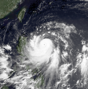
Typhoon Babs, known in the Philippines as Typhoon Loleng, was a powerful typhoon that struck the Philippines days after Typhoon Zeb hit the same area. The seventh typhoon of the inactive 1998 Pacific typhoon season, Babs formed on October 14 between the Philippines and Guam. The storm moved westward initially, failing to intensify initially due to the outflow from Typhoon Zeb to the northwest. Babs slowed and briefly turned to the south before advancing to the northwest, whereupon it rapidly intensified into a strong typhoon. On October 20, the official Japan Meteorological Agency (JMA) estimated peak 10‑minute winds of 155 km/h (96 mph), while the unofficial Joint Typhoon Warning Center (JTWC) estimated peak 1‑minute winds of 250 km/h (160 mph), making Babs an unofficial super typhoon. The storm struck the Philippine island of Catanduanes at that intensity and weakened slightly before hitting Luzon. Babs turned northward once in the South China Sea, later weakening due to unfavorable conditions and transitioning into an extratropical cyclone on October 27 in the Taiwan Strait.

Typhoon Chanchu, known in the Philippines as Typhoon Caloy, was the most intense typhoon in the South China Sea in the month of May according to the Hong Kong Observatory (HKO). The first named storm of the 2006 Pacific typhoon season, Chanchu formed on May 8 in the vicinity of the Federated States of Micronesia and progressed westward. It gradually intensified into a tropical storm and later severe tropical storm before moving through the Philippines. On May 13, Chanchu entered the South China Sea and became a typhoon, according to the Japan Meteorological Agency (JMA). Warm waters and favorable outflow allowed the storm to quickly intensify to peak maximum sustained winds of 175 km/h (109 mph) on May 15. Around that time, the typhoon turned sharply to the north toward southeastern China. Chanchu weakened as it curved to the northeast, making landfall near Shantou, Guangdong on May 17 as a severe tropical storm. The government of China considered Chanchu the earliest typhoon to make landfall in the province. On the next day, the storm emerged into the East China Sea, becoming extratropical on May 19 before dissipating west of Kyushu.

The 1989 North Indian Ocean cyclone season was a below-average season in annual cycle of tropical cyclone formation. Despite this, the season had the second highest Accumulated Cyclone Energy in the basin on record behind only 2019 and 2023. The season has no official bounds but cyclones tend to form between April and December. These dates conventionally delimit the period of each year when most tropical cyclones form in the northern Indian Ocean. There are two main seas in the North Indian Ocean—the Bay of Bengal to the east of the Indian subcontinent and the Arabian Sea to the west of India. The official Regional Specialized Meteorological Centre in this basin is the India Meteorological Department (IMD), while the Joint Typhoon Warning Center (JTWC) releases unofficial advisories. An average of five tropical cyclones form in the North Indian Ocean every season with peaks in May and November. Cyclones occurring between the meridians 45°E and 100°E are included in the season by the IMD.

Typhoon Dan, known in the Philippines as Typhoon Saling, was the third of a series of tropical cyclones that impacted the Philippines and Vietnam in October 1989. The storm developed on October 6, and tracked generally westward throughout its course. After crossing Luzon, the typhoon emerged into the South China Sea and reached its peak intensity, with sustained 10-minute winds of 140 km/h (85 mph), 1-minute winds of 130 km/h (80 mph), and a minimum barometric pressure of 960 millibars. The storm moved ashore in central Vietnam and dissipated after moving inland. The storm caused extensive damage throughout its course. In the Philippines, Dan left hundreds of thousands homeless and killed 58 people. Power outages were extensive in the Manila region. In Vietnam, the storm's high winds and heavy rains caused extensive damage and loss of life. More than 500,000 structures were damaged or destroyed and at least 43 people were killed across the country.

Typhoon Alex, known in the Philippines as Typhoon Etang, affected the Taiwan, China, and South Korea during July 1987. Typhoon Alex developed from the monsoon trough that spawned a tropical disturbance late on July 21 southwest of Guam which organized into a tropical depression shortly thereafter. The system steadily became better organized, and the next day, a tropical depression had developed. Satellite intensity estimates gradually increased, and on July 23, the depression intensified into Tropical Storm Alex. After initially tracking west-northwest, Tropical Storm Alex started tracking northwest. An eye developed on July 24, and on the next day, Alex was classified as a typhoon, when Alex attained its peak intensity of 120 km/h (75 mph) and a minimum barometric pressure of 970 mbar (29 inHg). Alex weakened while tracking more northward, though interaction with Taiwan resulted in a more westward track starting on July 27. The storm struck near Shanghai as a tropical storm, and weakened over land, although it remained identifiable through August 2.

Typhoon Amy, known in the Philippines as Typhoon Gening, was the second typhoon to strike China in a week during mid-July 1991. An area of convection was first observed on July 13 within the vicinity of Yap. A tropical depression developed the next day. While initially tracking westward, the system slowly deepened, becoming Tropical Storm Amy on July 16. After briefly turning northwestward, Amy intensified into a typhoon on July 17. Continuing to intensify as it tracked through the Luzon Strait, Amy reached its peak intensity of 175 km/h (110 mph) on July 18. That evening, the typhoon began to show signs of weakening, although it was still believed to have been a typhoon when it made landfall in the province of Guangdong on July 19, becoming the strongest tropical cyclone to hit the province in 22 years. Once inland, the storm rapidly weakened, and by late on July 20, had dissipated completely.

Typhoon Judy of July 1989 was a strong tropical cyclone that caused extensive damage and loss of life in Japan, South Korea and the eastern Soviet Union. Originating from a monsoon trough on July 21, Judy began as a tropical depression west of the Northern Mariana Islands. Tracking west-northwest, the system gradually intensified into a tropical storm and was given the name Judy on July 23. By this time, the storm had turned due north. Two days later, Judy attained typhoon status as it began a gradual turn to the west-northwest. Late on July 25, the storm peaked with winds of 165 km/h (105 mph). Striking Kyushu on July 27, interaction with the island's mountainous terrain caused Judy to quickly weaken as it neared South Korea. The weakened storm struck the country west of Pusan the following day before losing its identity near the border with North Korea. The remnants of Judy were last noted over the Sea of Japan.

Typhoon Gordon, known in the Philippines as Typhoon Goring, was a powerful tropical cyclone that caused widespread damage and loss of life in the Philippines and Southern China in July 1989. Gordon developed into a tropical depression near the Northern Mariana Islands on July 9 and quickly intensified as it tracked west-southwestward. On July 13, the storm attained typhoon status and subsequently underwent a period of rapid intensification. By July 15, the storm attained its peak strength as a Category 5 equivalent super typhoon with winds estimated at 260 km/h (160 mph). After striking the northern Philippines, Gordon moved through the South China Sea and slowly weakened. On July 18, the storm made landfall in southern China and was last noted the following day as it dissipated over land.

Typhoon Sinlaku was a damaging typhoon that affected Okinawa, Taiwan, and eastern China in September 2002. The 16th named storm of the 2002 Pacific typhoon season, Sinlaku formed on August 27 northeast of the Northern Marianas Islands. After initially moving to the north, it began a generally westward motion that it maintained for the rest of its duration. Sinlaku strengthened into a typhoon and attained its peak winds on August 31. Over the next few days, it fluctuated slightly in intensity while moving over or near the Ryukyu Islands. On September 4, the typhoon's eye crossed over Okinawa. It dropped heavy rainfall and produced strong winds that left over 100,000 people without power. Damage on the island was estimated at $14.3 million.

Typhoon Rammasun, known in the Philippines as Typhoon Florita, was the first of four typhoons to contribute to heavy rainfall and deadly flooding in the Philippines in July 2002. The fifth tropical cyclone of the 2002 Pacific typhoon season, Rammasun developed around the same time as Typhoon Chataan, only further to the west. The storm tracked northwestward toward Taiwan, and on July 2 it attained its peak intensity with winds of 155 km/h (96 mph). Rammasun turned northward, passing east of Taiwan and China. In Taiwan, the outer rainbands dropped rainfall that alleviated drought conditions. In China, the rainfall occurred after previously wet conditions, resulting in additional flooding, although damage was less than expected; there was about $85 million in crop and fishery damage in one province.

Typhoon Dujuan, known in the Philippines as Typhoon Onyok, was the strongest tropical cyclone to strike the Pearl River delta since Typhoon Hope in 1979. The 13th storm and 7th typhoon of the 2003 Pacific typhoon season, Dujuan developed on August 27 to the east of Taiwan. It initially moved to the northwest, slowly intensifying into a tropical storm while drawing moisture and rainfall over the Philippines. On the island of Luzon, one person was killed and areas were flooded. Dujuan quickly intensified after turning and moving quicker to the west-northwest, developing an eye. It reached peak winds of 150 km/h (93 mph) on September 1, and shortly thereafter passed just south of Taiwan. There, Dujuan left 590,000 people without power, killed three, and caused NT$200 million in crop damage. While moving through the South China Sea, the typhoon developed concentric eyewalls. Dujuan weakened to severe tropical storm status before making landfall on September 2 in southern China, just east of Hong Kong near Shenzhen, Guangdong. The storm dissipated the next day after causing 40 deaths and ¥2.3 billion in damage. Most of the deaths were in Shenzhen where the storm moved ashore, and the city experienced a near-total power outage.

Typhoon Abe, known as Typhoon Iliang in the Philippines, was the fourteenth named storm of 1990 Pacific typhoon season. Forming on August 23 from a tropical disturbance, the depression which would eventually develop into Typhoon Abe initially tracked in a steady west-northwestward direction. As a result of an intense monsoon surge, Abe's trajectory briefly changed to an eastward then northward path before returning to its original track. Abe only intensified by a small amount between 00:00 UTC August 24 and 06:00 UTC August 27 due to the disruptive effects of the surge, and on August 30, Abe peaked in intensity as a Category 2-equivalent typhoon on the Saffir–Simpson hurricane wind scale. After peaking in intensity, Abe crossed the Ryukyu Islands and the East China Sea, making landfall in China where it affected the provinces of Zhejiang and Jiangsu before entering the Yellow Sea, crossing South Korea, and finally transitioning into an extratropical cyclone.

Typhoon Abby, known as Typhoon Norming in the Philippines, was the second typhoon to affect Taiwan in a month during September 1986. A tropical depression developed on September 13 and the next day attained tropical storm status, upon which it was named Abby. Continuing to intensify, Abby moved west-northwest and became a typhoon on September 16. Two days later, the typhoon attained maximum intensity. On September 19, the typhoon made landfall in Taiwan as it turned towards the northwest. Rapid weakening occurred due to land interaction, and on September 20, Typhoon Abby transitioned into an extratropical cyclone. Its extratropical remnants were last noted on September 24 as they raced off to the northeast.
Typhoon Warren, known in the Philippines as Typhoon Huaning, struck the Philippines and China during July 1988. An area of disturbed weather developed within the vicinity of the Caroline Islands during the second week of July. A tropical depression developed southeast of Guam on July 12, and on the next day, intensified into a tropical storm. Tracking generally west-northwest, Warren deepened into a typhoon on July 14. The storm subsequently entered a period of rapid intensification, commencing with Warren reaching its highest intensity on July 16. The following evening, the typhoon brushed Luzon, resulting in a weakening trend, although Warren was still a typhoon when it made landfall near Shantou. Warren rapidly dissipated inland.

Typhoon Ofelia, known as Typhoon Bising in the Philippines, was the first of two typhoons in 1990 to directly affect the Philippines within a week. Typhoon Ofelia originated from an area of disturbed weather embedded in the monsoon trough situated near the Caroline Islands. Slowly organizing, the disturbance tracked westward, and was designated a tropical depression on June 15. After an increase in convection, the depression was upgraded into a tropical storm on June 17. On June 19, Ofelia turned northwest and after development of a central dense overcast, Ofelia was upgraded into a typhoon late on June 20. After turning north, Ofelia obtained its maximum intensity following the development of an eye. The typhoon skirted past the northeastern tip of Luzon and near the east coast of Taiwan, commencing a rapid weakening trend. On the evening on June 23, Ofelia struck the southern portion of Zhejiang. The storm then began to track north, recurving towards the Korean Peninsula. The storm tracked through the province of Jiangsu, and at 00:00 UTC on June 24, transitioned into an extratropical cyclone, only to merge with a frontal zone on June 25.


