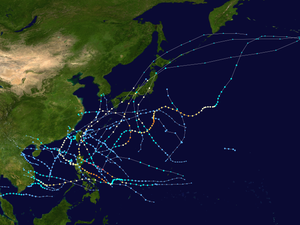
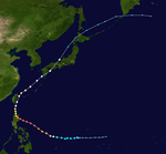
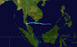
The 1998 Pacific typhoon season was at the time the least active Pacific typhoon season on record, until the record was surpassed 12 years later, spawning 16 tropical storms and 8 typhoons.[1] The scope of this article is limited to the Pacific Ocean, north of the equator and west of the international date line. Storms that form east of the date line and north of the equator are called hurricanes; see 1998 Pacific hurricane season. Tropical Storms formed in the entire west Pacific basin were assigned a name by the Joint Typhoon Warning Center. Tropical depressions in this basin have the "W" suffix added to their number. Tropical depressions that enter or form in the Philippine area of responsibility are assigned a name by the Philippine Atmospheric, Geophysical and Astronomical Services Administration or PAGASA. This can often result in the same storm having two names.
The 1998 season was very weak compared to the 1997 season; this was due to the strong El Niño in the previous season. During the 1998 season, a total of 28 tropical depressions developed across the western Pacific basin. Of those 28 depressions, a total of 18 strengthened into tropical storms of which 9 further intensified into typhoons. The first tropical cyclone developed on May28, marking the fourth latest start to any Pacific typhoon season on record, and the last one dissipated on December22. The Philippine region also set a record: with only eleven storms forming or moving into its area of responsibility, PAGASA had its quietest season on record, later tying with the 2010 season. Overall inactivity was caused by an unusually strong La Niña, which also fueled a hyperactive Atlantic hurricane season that year.
The second tropical depression of the season developed out of a tropical disturbance which was first noted 1,080km (670mi) north-northwest of Palau on July6. The disturbance gradually became better organized and was classified as Tropical Depression 01W at 1500UTC on July7. Upon becoming a depression, it marked the latest start for a Pacific typhoon season since reliable records began in 1959.[2] The next day, 01W entered the Philippine Atmospheric, Geophysical and Astronomical Services Administration (PAGASA) area of responsibility and received the local name Akang.[3] Slowly moving towards the northwest, the depression neared Taiwan. However, increasing vertical wind shear caused the convection associated with the depression to become displaced from the center of circulation. With the center exposed, 01W weakened. At 2100UTC on July10, the depression made landfall in northern Taiwan and dissipated shortly after. No known damage was caused by the depression.[2]
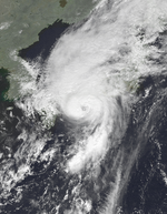
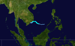
As 01W intensified over the Philippine Sea,[2] a broad area of low pressure developed in the South China Sea. The low slowly intensified as it moved towards the north-northeast and was declared Tropical Depression 02W early on July8. Tropical Depression 02W slowly strengthened as northerly outflow was constricted. By late on July8, the depression was upgraded to a tropical storm and given the name Nichole. The storm reached its peak intensity while just offshore southern Taiwan with winds of 95km/h (60mph 1-minute winds) according to the Joint Typhoon Warning Center (JTWC)[2] and 65km/h (40mph 10-minute winds) with a minimum pressure of 998hPa (mbar) according to the Japan Meteorological Agency (JMA).[4] The combination of dry air, strong wind shear, and the storm's proximity to land caused Nichole to quickly weaken to a tropical depression twelve hours after reaching its peak intensity. The exposed remnants of Nichole executed a clockwise-loop offshore Taiwan before traveling north into mainland China and dissipating.[2] Rough seas produced by the storm caused four container ships to run aground in Taiwans' Kaohsiung Harbor, none of the crew members were injured. Heavy rains in Taiwan flooded an estimated 2,500 acres (10km2) of crops.[5]
Operationally considered to have only been a tropical depression, Tropical Storm 03W developed out of a tropical disturbance along the eastern edge of a monsoon gyre on July22. Tracking in a gradual northwest to northeast curve, the disturbance gradually intensified and was classified as a tropical depression while located 790km (490mi) east-northeast of Iwo Jima on July25. The depression briefly intensified into a tropical storm, with a peak intensity of 85km/h (50mph 1-minute winds) as convection wrapped around the entire center of circulation. However, strong wind shear quickly blew away the associated convection, causing 03W to weaken to a tropical depression. Early on July26, 03W degenerated into an exposed low before dissipating.[2]
The first typhoon of the season developed out of a tropical low from a mesoscale disturbance in early August. Persistent convection developed around the low[6] and early on August2, the JTWC began issuing advisories on Tropical Depression 04W.[7]
Storm signals were put in place in the Philippines prior to the storm's arrival on August3.[8] However, Otto turned away from the country and the signals were discontinued on August5.[9] Typhoon Otto produced heavy rains, amounting to at least 400mm (15.7in) in mountainous areas of Taiwan, caused flooding which killed five people.[10][11] In all, damages in Taiwan amounted to NTD25million ($761,000 1998USD). After traveling through the Taiwan Strait, the typhoon struck China, producing heavy rainfall which caused flooding[12] in areas suffering from the worst flood in at least 45 years.[13] Officials reported no damage or loss of life resulted from the storm in Fujian Province.[14]
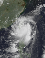
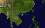
A tropical disturbance formed on August 2 and strengthened into a tropical depression east of the Philippines. As Penny strengthened into a tropical storm, it made landfall over Northern Luzon, on August 7, and drifted into the South China sea on the same day. Strong vertical wind shear on August 8 caused Penny's convection to be displaced to south of the storm, and even exposed the level circulation center for a few hours. Penny was only located 165 kilometers from Hong Kong when it was at its closest distance to Hong Kong, and killed one person in Hong Kong. Penny soon made landfall over Maoming on August 11, and dissipated the next day.
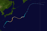
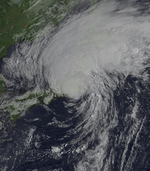
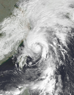
An active Tropical Upper Tropospheric Trough allowed for the development of Tropical Depression 6W on August 22, east of Luzon. It moved westward initially, but as the trough weakened a ridge to the east, it moved northeastward where it became a tropical storm on the 23rd. Rex slowly intensified to become a typhoon on the 26th, followed by reaching a peak of 135mph (217km/h) winds on the 28th south of Japan. As it moved northward, it brought heavy flooding to Honshū, Japan, amounting to 13 deaths and moderate damage from mudslides across the island. Another trough pulled the storm eastward, saving Japan from a direct hit, and Rex continued northeastward to an unusually high latitude near 50°, when it became extratropical on the 9th near the Aleutian Islands, east of the International Date Line.
On August 26, a monsoonal trough formed over central China and drifted south. On August 29, the trough spawned an embedded low over Taiwan, and strengthened into a tropical depression on September 1. Tropical Depression 07W fully dissipated on September 6 due to vertical wind shear.
In northern Japan, near Wakkanai, Hokkaidō, severe damage to many homes took place. One person in the region was killed after being blown off his roof while trying to repair it and twelve homes were destroyed. Several rivers overflowed their banks after rainfall exceeding 200mm (7.9in) fell across Hokkaidō. Throughout Sōya Subprefecture, agricultural and fishing industry losses amounted to 23.1million yen (US$171,213).[15] Severe flooding took place in nearby Abashiri Subprefecture where hundreds of homes were inundated after rivers broke their banks. Over 6,200ha (15,000 acres) of farmland was lost. Large sections of roadways were washed away, including 14 bridges. Total losses in Abashiri reached 25million yen (US$185,296), much of which was due to fishing industry damage.[16]
Severe damage was sustained in Iwamizawa, Hokkaidō after torrential rains triggered widespread flooding. One person was killed in the city and 29 buildings were destroyed. Agricultural losses in the area amounted to 14.9million yen (US$110,436).[17] Some of the worst floods were in Obihiro, where nearly 230million yen (US$1.7million) in agricultural losses was sustained. A third fatality from Stella took place in the area.[18]
Tropical Depression 09W developed in the South China Sea on September 12. It moved westward and struck Hainan and Vietnam before dissipating on September 14.
The monsoon trough spawned a low pressure system late on August 14, which developed into Tropical Storm Todd shortly thereafter. Interaction with a trough provided excellent outflow for the system, which explosively intensified over the following day, with 1-minute winds increasing from 50 knots to 130 knots in a 24-hour period ending at 06z on August 17. [19] However, the upper-level low that had been providing Todd with enhanced outflow soon began to shear it as it catapulted the storm northward and then westward, and by the time it had made landfall in China, Todd had weakened back into a tropical storm with 10-minute winds of 45 knots per the JMA.[20] Todd dissipated inland over China on August 20. Seven people were killed by Todd in Kyushu. Damage in southern Japan amounted to 31.9million yen (US$236,436).[21]
Vicki developed in the South China Sea west of Luzon on September 17. Vicki moved east and crossed Luzon. After landfalling on Luzon, Vicki moved northeast and struck the Kii Peninsula in Japan on September 22 before becoming extratropical. The storm caused the deaths of 108 people.
Tropical Depression 12W developed in the South China Sea on September 16. It moved west-northwestward and moved along the coast of Vietnam. The depression made landfall in that country before dissipating on September 19.
Tropical Depression 15W developed in the South China Sea on October 2. It initially moved northeastward, before later curving northwestward. The depression made landfall in Vietnam shortly before dissipating on October 5.
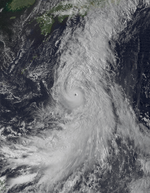
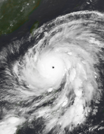
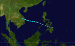
The monsoon trough near Guam developed a tropical depression on October 7. It moved westward, strengthening to a tropical storm on the 10th. The large inflow of the storm developed another tropical storm on the 10th; Tropical Storm Alex. The two moved westward, and as Zeb strengthened to a typhoon on the 11th, it absorbed the short-lived Tropical Storm Alex. It continued west-northwestward, rapidly intensifying to a 180mph (290km/h) super typhoon on the 13th with an official minimum central pressure of 900millibars and an unofficial minimum central pressure of 872millibars, which would tie for the second lowest on record. Zeb maintained this intensity until hitting Luzon in the Philippines on the 14th. After weakening over the archipelago Zeb moved northward to hit Taiwan as a minimal typhoon on the 15th. It maintained this intensity until hitting Japan on the 17th, after which it became extratropical on the 18th. Zeb was responsible for 122 casualties in its path.[22]
On October10, a small area of low pressure developed within the outflow of Typhoon Zeb. The low maintained an area of deep convection and quickly strengthened into a tropical storm.[23][24] Operationally, the system was not classified as a tropical storm until 0600UTC on October11.[23] Zeb then brought stronger wind shear over Alex, ultimately absorbing the short lived Alex. Alex reached the intensity of tropical storm with sustained winds of 45 knots over 1 minute according to the Joint Typhoon Warning Center[25]
A tropical disturbance in association with the TUTT (Tropical Upper Tropospheric Trough) formed into a tropical depression on October 11 near Guam. It moved westward under the influence of the Subtropical Ridge, and became a tropical storm on the 15th. Babs slowly intensified due to little upper level outflow, but when the outflow became more pronounced, it strengthened to a typhoon on the 19th and a super typhoon with a peak of 155mph (249km/h) winds on the 20th. Babs hit the central Philippines as a Category4, and flooded an area just hit by another super typhoon, Zeb, only 7days before. Babs weakened over the islands, and turned north where upper level shear caused it to dissipate on the 27th. Super Typhoon Babs caused heavy mudslides in the Philippines, resulting in more than 300 deaths and heavy flooding.
A monsoonal low that persisted over the South China Sea began to coalesce on November 10, and on the following day, the system became organized enough to be classified as a depression, receiving the designation 21W by the Joint Typhoon Warning Center. Although the depression initially struggled due to vertical wind shear displacing convection to the west of the center, gradual improvement in structure led to the system being upgraded into a tropical storm early on November 12 and receiving the name Chip. Gradually organizing as it moved northwest slowly, Chip reached peak 1-minute winds of 50 knots and 10-minute sustained winds of 40 knots per the JTWC and JMA respectively shortly before its landfall in Vietnam early on November 14. [26]
Chip killed at least 17 people and caused VND16.2billion ($923,4001998USD) in Vietnam. The remnants of Chip regenerated into a tropical cyclone over the Bay of Bengal. Peaking as a strong Category 1 cyclone, it then was known as Cyclone 07B when its remnants cross Vietnam, Thailand, and Cambodia . The system made landfall in Bangladesh, killing 100 people.
Though a weak tropical storm, torrential rains from Dawn triggered catastrophic flooding in Vietnam, killing at least 187 people. Regarded as the worst cyclone to hit the region in three decades, 500,000 homes flooded, an additional 7,000 were destroyed and an estimated 2million people were left homeless. Damage was estimated at VND400billion (US$28million).[27]
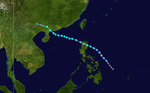
Tropical Storm Faith moved westward across the northwestern Pacific. It strengthened to a typhoon just as it crossed over the Philippines, an area hit by several typhoons this season. After reaching a peak of 100mph (160km/h) winds over the South China Sea, Faith weakened to a tropical storm on December 14 just before making landfall on eastern Vietnam. It dissipated later that day.
In the Philippines, a total of eight people were killed and 17 others were reported as missing. Throughout the country, 51,785 people were displaced and another 20,419 were evacuated. Damages amounted to PHP513.95million (US$13million).[28] In Vietnam, 40 people were killed and three others were left missing. A total of 602 homes were destroyed, another 16,327 were damaged, and 58,487ha of rice fields were inundated. Damages in the country amounted to VND204billion (US$15million).[29]
Tropical Storm Gil developed in the South China Sea on December 8. It moved westward and peaked with winds of 75km/h (45mph). Gil made landfall in Thailand as a tropical depression which caused a plane crash at Surat Thani due to bad weather before dissipating on December 13.
The final tropical depression of the season developed from a poorly organized tropical disturbance on December18 over the South China Sea. Situated within an unfavorable environment, the system struggled to maintain deep convection; however, the following day, it was classified as Tropical Depression 27W by the JTWC. Operationally, 27W was regarded as a tropical storm, with maximum winds of 75km/h (45mph) but in post-season analysis, the intensity was lowered to 55km/h (35mph).
During the season 17 named tropical cyclones developed in the Western Pacific and were named by the Joint Typhoon Warning Center, when it was determined that they had become tropical storms. These names were contributed to a revised list which started on 1996.
Nichole
Otto
Penny
Rex
Stella
Todd
Vicki
Waldo
Yanni
Zeb
Alex
Babs
Chip
Dawn
Elvis
Faith
Gil
Philippines
Akang
Bising
Klaring
Deling
Emang
Gading
Heling
Iliang
Loleng
Miding
Norming
Oyang(unused)
Pasing(unused)
Ritang(unused)
Susang(unused)
Tering(unused)
Uding(unused)
Weling(unused)
Yaning(unused)
Auxiliary list
Aning(unused)
Bidang(unused)
Katring(unused)
Delang(unused)
Esang(unused)
Garding(unused)
The Philippine Atmospheric, Geophysical and Astronomical Services Administration uses its own naming scheme for tropical cyclones in their area of responsibility. PAGASA assigns names to tropical depressions that form within their area of responsibility and any tropical cyclone that might move into their area of responsibility. Should the list of names for a given year prove to be insufficient, names are taken from an auxiliary list, the first 10 of which are published each year before the season starts. This is the same list used for the 1994 season. PAGASA uses its own naming scheme that starts in the Filipino alphabet, with names of Filipino female names ending with "ng" (A, B, K, D, etc.). Because PAGASA started a new naming scheme in 2001, therefore, this naming list was not used in the 2002 season. Names that were not assigned/going to use are marked in gray.
Season effects
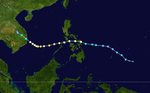
This table summarizes all the systems that developed within or moved into the North Pacific Ocean, to the west of the International Date Line during 1998. The tables also provide an overview of a systems intensity, duration, land areas affected and any deaths or damages associated with the system.
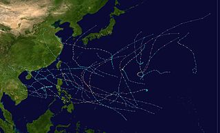
The 2004 Pacific typhoon season was an extremely active season that featured the second-highest ACE ever recorded in a single season, second only to 1997, which featured 29 named storms, nineteen typhoons, and six super typhoons. It was an event in the annual cycle of tropical cyclone formation, in which tropical cyclones form in the western Pacific Ocean. The season ran throughout 2004, though most tropical cyclones typically develop between May and October. The season's first named storm and also the first typhoon, Sudal, developed on April 4, later was reached typhoon status two days later, and became the first super typhoon of the year three days later. The season's last named storm, Noru, dissipated on December 21.
The 2003 Pacific typhoon season was a slightly below average yearlong period of tropical cyclogenesis exhibiting the development of 45 tropical depressions, of which 21 became named storms; of those, 14 became typhoons. Though every month with the exception of February and March featured tropical activity, most storms developed from May through October. During the season, tropical cyclones affected the Philippines, Japan, China, the Korean Peninsula, Indochina, and various islands in the western Pacific.
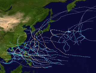
The 2002 Pacific typhoon season was a slightly above average Pacific typhoon season, producing twenty-six named storms, fifteen becoming typhoons, and eight super typhoons. It had an ACE over 400 units, making it one of the most active seasons worldwide. It was an event in the annual cycle of tropical cyclone formation, in which tropical cyclones form in the western Pacific Ocean. The season ran throughout 2002, though most tropical cyclones typically develop between May and October. The season's first named storm, Tapah, developed on January 11, while the season's last named storm, Pongsona, dissipated on December 11. The season's first typhoon, Mitag, reached typhoon status on March 1, and became the first super typhoon of the year four days later.
The 2001 Pacific typhoon season was the fourth and final consecutive year with below-average activity, making it the lowest four-year period of activity since 1976–1979, due to the presence of a strong La Niña that had persisted from 1998 to 2001. However, it was more active than the previous seasons, producing twenty-five named storms, sixteen typhoons and three super typhoons, with a near normal Accumulated Cyclone Energy (ACE) of 307.3 units. It ran year-round in 2001, with most tropical cyclones in the northwestern Pacific Ocean tending between May and November.
The 2000 Pacific typhoon season marked the first year using names contributed by the World Meteorological Organization. It was a rather below-average season, producing a total of 23 tropical storms, 13 typhoons and 4 intense typhoons. The season ran throughout 2000, though typically most tropical cyclones develop between May and October. The season's first named storm, Damrey, developed on May 7, while the season's last named storm, Soulik, dissipated on January 4 of the next year.
The 1999 Pacific typhoon season was the last Pacific typhoon season to use English names as storm names. It also featured the lowest number of typhoons on record with only five reaching this intensity. The season was a below-average season with only 20 named storms spawning. It had no official bounds; it ran year-round in 1999, but most tropical cyclones tend to form in the northwestern Pacific Ocean between May and November. These dates conventionally delimit the period of each year when most tropical cyclones form in the northwestern Pacific Ocean. The first named storm, Hilda, developed on January 6, while the last named storm, Gloria, dissipated on November 16.
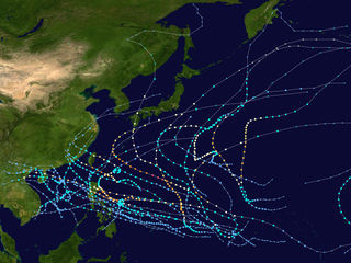
The 1997 Pacific typhoon season was a record-breaking season featuring 11 tropical cyclones reaching super typhoon intensity, tying the record with 1965 with the most violent tropical cyclones globally, and was the ninth and last consecutive year of above-average tropical cyclone activity that started in 1989. Its extremely high activity produced a total of 570 ACE index, which is the highest ever index recorded in a single tropical cyclone season. In addition, this season had 10 Saffir-Simpson Category 5-equivalent tropical cyclones, the most ever recorded, even greater than the 2005 Atlantic hurricane season, which had nearly half of the amount. The 1997–98 El Niño event was a contributing factor to this unusually high activity. Despite this, the season produced an average number of tropical storms, spawning 28 tropical storms.
The 1996 Pacific typhoon season was a relatively active season, producing 30 tropical storms, 16 typhoons and six super typhoons. It has no official bounds; it ran year-round in 1996, but most tropical cyclones tend to form in the northwestern Pacific Ocean between May and November. These dates conventionally delimit the period of each year when most tropical cyclones form in the northwestern Pacific Ocean. However the first named storm, Ann, did not develop until April 3. The final named storm, Greg, dissipated on December 27.
The 1994 Pacific typhoon season was an extremely active season in the annual cycle of tropical cyclone formation in the Western North Pacific, with a total of 32 tropical storms, where 19 of them reached typhoon strength, during the course of the season, much like the Pacific hurricane season. The season had no official bounds and it ran year-round in 1994, but most tropical cyclones tend to form in the northwestern Pacific Ocean between May and November. Tropical storms that formed west of the date line were assigned a name by the Joint Typhoon Warning Center. The World Meteorological Organization-designated Regional Specialized Meteorological Centre for tropical cyclones for the region is the Japan Meteorological Agency. Tropical depressions that entered or formed in the Philippine area of responsibility were assigned a name by the Philippine Atmospheric, Geophysical and Astronomical Services Administration or PAGASA. This can result in some storms having two names.
The 1991 Pacific typhoon season was a slightly above-average season with 29 tropical storms, 17 typhoons and five super typhoons forming. It was quite a catastrophic season – Typhoon Yunya impacted the Philippines in mid June while in the same time experiencing a volcanic eruption, Typhoon Mireille severely impacting Japan, which became known for being the costliest typhoon on record with US$10 billion worths of damages, and Tropical Storm Thelma on November which became one of the most deadliest storms to strike the Philippines, killing just over 5,000 people.
The 1990 Pacific typhoon season was another active season. It has no official bounds; it ran year-round in 1990, but most tropical cyclones tend to form in the northwestern Pacific Ocean between May and November. These dates conventionally delimit the period of each year when most tropical cyclones form in the northwestern Pacific Ocean.
The 1986 Pacific typhoon season has no official bounds; it ran year-round in 1986, but most tropical cyclones tend to form in the northwestern Pacific Ocean between May and December. These dates conventionally delimit the period of each year when most tropical cyclones form in the northwestern Pacific Ocean. Tropical Storms formed in the entire west pacific basin were assigned a name by the Joint Typhoon Warning Center. Tropical depressions that enter or form in the Philippine area of responsibility are assigned a name by the Philippine Atmospheric, Geophysical and Astronomical Services Administration or PAGASA. This can often result in the same storm having two names.
The 1985 Pacific typhoon season was an extremely active season, featuring 28 named storms, 15 typhoons and 1 super typhoon. It ran year-round in 1984, but again all tropical cyclones formed between June and December. These dates conventionally delimit the period of each year when most tropical cyclones form in the northwestern Pacific Ocean. A total of 57 tropical depressions formed this year, of which only 28 became tropical storms and were assigned a name by the Joint Typhoon Warning Center. This made the season well above average. Additionally, tropical depressions that enter or form in the Philippine area of responsibility were assigned a name by the Philippine Atmospheric, Geophysical and Astronomical Services Administration or PAGASA. This can often result in the same storm having two names. This year, a total of 17 storms were named this way.
The 1984 Pacific typhoon season had the second-latest start in the basin on record, only behind the previous year by one day. Despite this, it was above average in terms of named storms and featured many intense storms. It ran year-round in 1984, but again all tropical cyclones formed between June and December. These dates conventionally delimit the period of each year when most tropical cyclones form in the northwestern Pacific Ocean. A total of 44 tropical depressions formed this year, of which only 27 became tropical storms and were assigned a name by the Joint Typhoon Warning Center. This made the season above average when compared to the long term mean of 25 storms per season. Additionally, tropical depressions that enter or form in the Philippine area of responsibility are assigned a name by the Philippine Atmospheric, Geophysical and Astronomical Services Administration or PAGASA. This can often result in the same storm having two names. This year, a total of 20 storms were named this way.
The 1983 Pacific typhoon season was the latest start for a Pacific typhoon season on record, and also slightly below-average in terms of named storms. It ran year-round in 1983, but all tropical cyclones formed between June and December. These dates conventionally delimit the period of each year when most tropical cyclones form in the northwestern Pacific Ocean. A total of 32 tropical depressions formed this year, of which only 23 became tropical storms and were assigned a name by the Joint Typhoon Warning Center. Additionally, tropical depressions that enter or form in the Philippine area of responsibility are assigned a name by the Philippine Atmospheric, Geophysical and Astronomical Services Administration or PAGASA. This can often result in the same storm having two names. This year, a total of 23 storms were named this way.
The 1981 Pacific typhoon season was a slightly above average season that produced 29 tropical storms, 13 typhoons and two intense typhoons. The season ran throughout 1981, though most tropical cyclones typically develop between May and October. The season's first named storm, Freda, developed on March 12 while the final storm, Lee, dissipated on December 29. Tropical cyclones only accounted for 12 percent of the rainfall in Hong Kong this season, the lowest percentage for the protectorate since 1972.
The 1980 Pacific typhoon season was a slightly-below average season when compared to the long-term average, though it featured several intense storms. It ran year-round in 1980, but most tropical cyclones formed between June and December. These dates conventionally delimit the period of each year when most tropical cyclones form in the northwestern Pacific Ocean. A total of 28 tropical depressions formed this year in the Western Pacific, of which 24 became tropical storms and were assigned a name by the Joint Typhoon Warning Center. Beginning in March, tropical cyclones formed in each subsequent month through December. Of the 24 named storms, 15 storms reached typhoon intensity, of which 2 reached super typhoon strength.
The 1979 Pacific typhoon season featured the largest and most intense tropical cyclone recorded globally, Typhoon Tip. The season also experienced slightly above-average tropical cyclone activity. The season had no official bounds; it ran year-round in 1979, but most tropical cyclones tend to form in the northwestern Pacific Ocean between June and December. These dates conventionally delimit the period of each year when most tropical cyclones form in the northwestern Pacific Ocean.
The 1970 Pacific typhoon season has no official bounds; it ran year-round in 1970, but most tropical cyclones tend to form in the northwestern Pacific Ocean between June and December. These dates conventionally delimit the period of each year when most tropical cyclones form in the northwestern Pacific Ocean.
The 1975 Pacific typhoon season was one of the deadliest tropical cyclone seasons on record, with nearly 229,000 fatalities occurring during the season. It had no official bounds; it ran year-round in 1975, but most tropical cyclones tend to form in the northwestern Pacific Ocean between June and December. These dates conventionally delimit the period of each year when most tropical cyclones form in the northwestern Pacific Ocean.
This page is based on this Wikipedia article Text is available under the CC BY-SA 4.0 license; additional terms may apply. Images, videos and audio are available under their respective licenses.