1998 North Indian Ocean cyclone season

Last updated

1998 North Indian Ocean cyclone season
1998 North Indian Ocean cyclone season summary.jpg
Season summary map
Seasonal boundaries
First system formedMay 17, 1998
Last system dissipatedDecember 17, 1998
Strongest storm
Name ARB 02
  Maximum winds165 km/h (105 mph)
(3-minute sustained)
  Lowest pressure958 hPa (mbar)
Seasonal statistics
Depressions12
Deep depressions10
Cyclonic storms6
Severe cyclonic storms5
Very severe cyclonic storms3
Extremely severe cyclonic storms1
Super cyclonic storms0
Total fatalities≥10,212 direct, 12 indirect, >4,353 missing
Total damageAt least $3 billion (1998 USD)
Related articles
North Indian Ocean tropical cyclone seasons
1996, 1997, 1998, 1999, 2000

The 1998 North Indian Ocean cyclone season was an active season in annual cycle of tropical cyclone formation. The season has no official bounds but cyclones tend to form between April and December. These dates conventionally delimit the period of each year when most tropical cyclones form in the northern Indian Ocean. There are two main seas in the North Indian Ocean—the Bay of Bengal to the east of the Indian subcontinent and the Arabian Sea to the west of India. The official Regional Specialized Meteorological Centre in this basin is the India Meteorological Department (IMD), while the Joint Typhoon Warning Center releases unofficial advisories. An average of four to six storms form in the North Indian Ocean every season with peaks in May and November. [1] Cyclones occurring between the meridians 45°E and 100°E are included in the season by the IMD. [2]

Contents

With eleven depressions and eight tropical cyclones, this was one of the most active seasons in the ocean along with 1987, 1996, and 2005. [3] The season caused a large loss of life, most of which was from one storm. Over 10,000 people were killed in India when Tropical Cyclone 03A brought a 4.9-metre (16-foot) storm surge to the Kathiawar Peninsula, inundating numerous salt mines. Total damages from the storm amounted to Rs.  120 billion (US$3 billion). Tropical Cyclone 01B killed at least 26 people and left at least 4,000 fishermen missing in eastern Bangladesh on May 20. A short lived depression in mid-October killed 122 people after triggering severe flooding in Andhra Pradesh. In November, Tropical Cyclone 06B killed six people and caused property damage worth BTN  880 million (US$20.7 million) in eastern India. An additional 40 people were killed and 100 fishermen were listed as missing after Tropical Cyclone 07B affected Bangladesh.

Season summary

1998 Andhra Pradesh cyclone1998 Gujarat cyclone1998 North Indian Ocean cyclone season

The first storm of the season developed on May 18 out of an area of low pressure over the Bay of Bengal. It reached its peak intensity with winds of 130 km/h (81 mph) before making landfall near Chittagong, Bangladesh. The storm dissipated shortly after. [4] Later that month, a short-lived storm developed over the Arabian Sea and dissipated the next day without impacting land. [5] The most intense storm of the season formed in early June off the southwestern coast of India. It slowly traveled towards the west, remaining relatively weak before turning towards the north and intensifying. The storm reached its peak intensity with winds of 195 km/h (121 mph) shortly before making landfall near Porbandar in the Indian state of Gujarat. The cyclone rapidly dissipated on the same day. [6]

After three months of inactivity, five storms developed in late September and October. [7] Two of them strengthened into tropical storms, neither of which impacted land. [8] [9] In early November, the sixth tropical cyclone of the season developed in the Bay of Bengal. The storm quickly developed and reached its peak intensity upon landfall with winds of 155 km/h (96 mph). The storm rapidly dissipated the same day it made landfall. [10] Shortly after 06B dissipated, the remnants of Tropical Storm Chip [11] triggered the development of a new cyclone over the Bay of Bengal. The storm tracked along the edge of a subtropical ridge, reaching its peak intensity over open waters with winds of 140 km/h (87 mph). The cyclone entered an area of higher wind shear shortly after and rapidly weakened before making landfall. Then it dissipated in Bangladesh. [12] The final cyclone of the season developed in the Arabian Sea during mid-December. It reached its peak intensity with winds of 120 km/h (75 mph) before weakening due to strong wind shear. It made landfall in Oman on December 17 as a minimal tropical storm shortly before dissipating. [13]

Systems

Severe Cyclonic Storm BOB 01 (01B)

Severe cyclonic storm (IMD)
Category 1 tropical cyclone (SSHWS)
Tropical Cyclone 01B 1998.jpg   Cyclone 01B 1998 track.png
DurationMay 17 – May 20
Peak intensity110 km/h (70 mph) (3-min);
972  hPa  (mbar)

The first cyclone in the region developed as a tropical disturbance on May 13 over the southern Bay of Bengal to the southeast of Sri Lanka. [4] At 0700 UTC on May 17, the Joint Typhoon Warning Center (JTWC) issued a Tropical Cyclone Formation Alert (TCFA). [14] Shortly after, the India Meteorological Department (IMD) declared that the disturbance developed into Depression BOB 01. [15] At 0600 UTC on May 18, the first advisory on Tropical Cyclone 01B was issued by the JTWC, [4] while the IMD upgraded BOB 01 to a deep depression. [15]

Continuing on a northeasterly track, BOB 01 gradually intensified as it neared Bangladesh, strengthened into a cyclonic storm twelve hours later. [14] Early on May 20, BOB 01 reached its peak intensity as a severe cyclonic storm with winds of 110 km/h (68 mph) and a barometric pressure of 972 mbar (hPa). [15] The JTWC assessed the storm to have peaked with winds of 130 km/h (81 mph), equivalent to a Category 1 hurricane on the Saffir–Simpson Hurricane Scale. [4] An eye developed and the system made landfall several hours later near Chittagong. [14] After making landfall, the storm quickly weakened, [14] dissipating later that day. [4]

Ahead of the storm, officials in Bangladesh relocated an estimated 650,000 people, resulting in a lower loss of life. [16] But BOB 01 adversely affected low-lying areas, [4] destroying 6,000 homes and damaging another 9,945. [16] [17] It produced a storm surge of 1.8 to 3 m (5.9 to 9.8 ft), inundating coastal towns. [18] At least 35 people were killed by the storm and 504 others were injured. [16] [19] [20] Additionally, an estimated 4,000 fishermen were listed as missing at sea. [21] Two ships owned by the Bangladesh Shipping Corporation sustained significant damage. [20]

Depression ARB 01 (02A)

Depression (IMD)
Tropical storm (SSHWS)
02A 1998-05-28 0000Z.png   Cyclone 02A 1998 track.png
DurationMay 28 – May 29
Peak intensity45 km/h (30 mph) (3-min);
997  hPa  (mbar)

On May 27, an area of low pressure developed over the central Arabian Sea. [5] Early the next day, the JTWC issued their first advisory on Tropical Cyclone 02A while the system was located about 740 km (460 mi) south of Masirah Island. [14] The IMD only briefly monitored the system as a weak depression, designating it as ARB 01. [22] Upon being classified a tropical cyclone, 02A reached its peak intensity. The speed of its winds was 65 km/h (40 mph). [5] Soon, it began to dissipate due to increasing vertical wind shear. The center of circulation quickly became devoid of convection. The storm weakened below tropical storm intensity later that day before dissipating on May 29 over open waters. [5] [14]

Extremely Severe Cyclonic Storm ARB 02 (03A)

Extremely severe cyclonic storm (IMD)
Category 3 tropical cyclone (SSHWS)
03A 1998-06-08 1330Z.png   Cyclone 03A 1998 track.png
DurationJune 4 – June 10
Peak intensity165 km/h (105 mph) (3-min);
958  hPa  (mbar)

On June 1, an area of low pressure developed over the Laccadive Islands. Two days later, the JTWC issued a TCFA for the system as it became better organized. Early on June 4, the JTWC issued its first advisory on Tropical Cyclone 03A. [6] Around the same time, the IMD began monitoring the system as Depression ARB 02. Shortly after, the depression was upgraded to a deep depression and further strengthened into a cyclonic storm the following day. [15] The small storm moved slowly towards the west and weakened as wind shear began to increase. The storm weakened below tropical storm intensity later that day and the initial final advisory was issued. However, the system redeveloped and advisories resumed the next day. The storm gradually intensified as it moved towards the northwest. Dvorak satellite intensity estimates on June 6 reached T4.0, corresponding to an intensity of 120 km/h (75 mph). [23] The IMD also marked the increase in intensity, upgrading ARB 02 to a severe cyclonic storm. [15] Around this time, the storm began to turn towards the north and accelerate due to an approaching mid-level trough. As the storm neared the Indian coastline, an eye developed and the storm strengthened into the equivalent of a major hurricane with winds reaching 185 km/h (115 mph). [6] The IMD assessed the storm to be a very severe cyclonic storm at this time, with winds up to 165 km/h (103 mph) and a barometric pressure of 958 mbar (hPa). [15] After slightly weakening early on June 9, [23] 03A re-strengthened, attaining its peak intensity with winds of 195 km/h (121 mph). [6] Then it made landfall near Porbandar in the Indian state of Gujarat [23] between 0100 and 0200 UTC. [15] The storm weakened following landfall and the JTWC issued their final advisory later that day. [6] The IMD continued to monitor ARB 02 until June 10, by which time it had weakened to a depression before dissipating. [15]

Tropical Cyclone 03A brought a large storm surge of 4.9 m (16 ft) which devastated coastal communities and salt mines. [23] An estimated 4,000 to 10,000 people were killed by the storm, [24] [25] many of whom were salt mine workers who did not own a radio and received little or no warning of the cyclone. The large loss of life was partially attributed to contractors who wanted to continue making profits and did not inform their workers of the approaching storm. [23] According to the official figures, 1173 people died and 1774 people went missing. [25] Also, the region had witnessed only 17 cyclones since 1890, all of which were weaker than 03A. As a result, its vulnerability was miscalculated by the local population and the disaster management administration. [26] Power supply to numerous residences was lost due to the storms high winds. [27] A microwave tower in Porbandar collapsed, causing widespread disruption in telecommunication. [28] Hundreds of other power transmission towers also fell, causing an estimated loss of Rs 10 billion for the Gujarat Electricity Board. [29] At least 893 people were injured by the storm and over 11,000 animals were killed. Over 162,000 structures were damaged or destroyed throughout the affected area and damages amounted to Rs.  120 billion (US$3 billion). [30] In Kandla, the damages were estimated around 1,855.33 crore (equivalent to 84 billionorUS$1.0 billion in 2023). [25] Over the next one month, insurance companies had lost approximately Rs. 13 billion (US$266.5 million). [29] The remnants of the storm produced heavy rains over Pakistan which electrocuted 12 people. [23] In the wake of the storm, the United States Government provided US$25,000 for rehabilitation of the affected population. [30] The Government of Denmark also contributed $72,992 in funds for relief efforts. [31] The Gujarat government deployed approximately 330 medical teams to the affected areas. Local aid, amounting to Rs 1 billion (US$20.5 million) was provided to assist victims. [30]

Deep Depression BOB 02

Deep depression (IMD)
BOB 02 1998-06-14 1336Z.png   BOB-02 1998 track.png
DurationJune 13 – June 15
Peak intensity55 km/h (35 mph) (3-min);
992  hPa  (mbar)

On June 13, the IMD began monitoring a depression over the central Bay of Bengal. Tracking towards the west, the depression intensified into a deep depression, peaking with winds of 55 km/h (34 mph) and a minimum pressure of 992 mbar (hPa). Around 15:00 UTC on June 14, the deep depression made landfall near Visakhapatnam. Shortly thereafter, it weakened to a depression and dissipated early the following day. [15]

Depression ARB 03 (04A)

Depression (IMD)
Tropical storm (SSHWS)
04A 1998-09-30 0209Z.png   Cyclone 04A 1998 track.png
DurationSeptember 30 – October 1
Peak intensity45 km/h (30 mph) (3-min);
997  hPa  (mbar)

In late September, an area of low pressure developed over the Arabian Sea within an east–west oriented surface trough while located about 740 km (460 mi) west of Mumbai, India. The system gradually intensified as it moved slowly towards the west. [8] Early on September 30, the JTWC issued its first advisory on Tropical Cyclone 04A. Its winds peaked at 65 km/h (40 mph). Located within an area of moderate wind shear, the storm quickly weakened [32] and dissipated early on October 1. [8]

Deep Depression ARB 04

Deep depression (IMD)
ARB 04 1998-10-08 1019Z.png   ARB-04 1998 track.png
DurationOctober 6 – October 9
Peak intensity55 km/h (35 mph) (3-min);
998  hPa  (mbar)

On October 8, the IMD began monitoring a tropical depression located about 835 km (519 mi) southwest of Mumbai. The depression was briefly classified as a deep depression with winds of 55 km/h (34 mph) and a minimum pressure of 998 mbar (hPa) as it moved towards the west-northwest. Shortly after reaching its peak intensity, the depression weakened. The last advisory was issued the next day while the storm was over open waters. [7] [15]

Cyclonic Storm ARB 05 (05A)

Cyclonic storm (IMD)
Tropical storm (SSHWS)
05A 1998-10-16 1452Z.png   Cyclone 05A 1998 track.png
DurationOctober 11 – October 18
Peak intensity65 km/h (40 mph) (3-min);
996  hPa  (mbar)

The IMD began monitoring an area of low pressure over the Laccadive Islands on October 10. The low traveled towards the northwest with little development. [7] On October 15, the JTWC issued a TCFA as the system became better organized. Although wind shear increased, the first advisory was issued the next day. With minimal convection, the storm never intensified past 65 km/h (40 mph). [9] The system traveled towards the northeast and weakened due to strong wind shear. On October 17, the storm fell below tropical storm status and made landfall on the Kathiawar Peninsula, near the same area where 03A made landfall in early June. [7] The storm dissipated shortly after landfall. [7] [9]

As the storm neared land, officials in Gujarat evacuated hundreds of residents from coastal areas. Due to the low-intensity of the storm, no damage was reported on land and only light rain fell. However, offshore, more than 250 people were reported as missing when contact was lost with numerous fishing vessels. One-hundred-twenty people on twelve ships from Satpathy village were among the missing. One of the ships capsized; however, the crew of 12 swam to shore. One boat from Vasai carrying 20 people was also missing. Ten fishermen from Colaba were reported as missing, three of which later swam to shore. The Indian Coast Guard immediately dispatched search and rescue ships and naval helicopters to find the missing people. [33] [34]

Deep Depression BOB 03

Deep depression (IMD)
BOB 03 1998-10-14 0911Z.png   BOB-03 1998 track.png
DurationOctober 13 – October 15
Peak intensity55 km/h (35 mph) (3-min);
998  hPa  (mbar)

On October 13, the IMD began monitoring a tropical depression off the eastern coast of India. [7] The depression remained relatively weak, with winds peaking at 45 km/h (28 mph) before the storm made landfall near Narsapur in the Andhra Pradesh early on October 14. [35] The depression dissipated shortly after landfall. [7] Heavy rains produced by the depression damaged croplands and property. [36] Twenty-four-hour rainfall totals reached 110 mm (4.3 in) in localized areas, triggering flash floods in areas severely impacted by another system a week earlier. In Hyderabad, schools and government offices were closed. [37] During the morning of October 14, overflow from a dam inundated the Srisailam powerhouse, forcing officials to shut down the plant. Numerous highways were also closed due to flowing water. [38] The following day, the water level of the dam continued to rise, leading to the evacuation of nearly 53,000 residents in the area. [39] Throughout Andhra Pradesh, flooding from the depression resulted in 101 fatalities. [40]

Deep Depression BOB 04

Deep depression (IMD)
BOB 04 1998-10-28 0011Z.png   BOB-04 1998 track.png
DurationOctober 26 – October 29
Peak intensity55 km/h (35 mph) (3-min);
1002  hPa  (mbar)

Early on October 28, the IMD began monitoring a tropical depression located about 555 km (345 mi) south-southeast of Visakhapatnam in the Andhra Pradesh. The depression strengthened to a deep depression later that day with winds peaking at 55 km/h (34 mph) before undergoing a weakening trend. The depression dissipated the next day near the Andhra Pradesh coastline. [7] The outer bands of the depression produced light rainfall over the coast of Andhra Pradesh. [41]

Very Severe Cyclonic Storm BOB 05 (06B)

Very severe cyclonic storm (IMD)
Category 2 tropical cyclone (SSHWS)
06B 1998-11-15 0632Z.png   Cyclone 06B 1998 track.png
DurationNovember 13 – November 16
Peak intensity145 km/h (90 mph) (3-min);
982  hPa  (mbar)

On November 10, an area of low pressure developed over the Bay of Bengal within a monsoonal trough. Moving towards the northwest, [42] the low gradually developed and the JTWC issued a TCFA early on November 13. The next day, the first advisory on Tropical Cyclone 06B was issued. [10] A brief period of rapid development took place as the storm strengthened just below Category 1 status. Shortly before making landfall near Visakhapatnam, [42] 06B reached its peak intensity with winds of 155 km/h (96 mph). [10] At this time, the IMD classified the cyclone as a Very Severe Cyclonic Storm and reported that it had a 60 km (37 mi) wide eye. [43] Rapid weakening followed shortly after landfall and the storm dissipated early on November 16. [10] [42]

Major crop losses, property damage, and six fatalities were reported from the affected areas. [10] [44] Four of the fatalities were in Visakhapatnam and the other two were in east Godavari. [45] Hundreds of trees and power lines had fallen. [46] At least 116,000 acres (470 km2) of cropland and more than 2,000 homes were damaged. [45] [47] Waves produced by the storm at Visakhapatnam were recorded up to 5.74 m (18.8 ft). [48] The storm dropped rainfall in excess of 100 mm (3.9 in) throughout the region. [43] Damages from the storm were estimated at BTN  880 million (US$20.7 million). [49]

Very Severe Cyclonic Storm BOB 06 (07B)

Very severe cyclonic storm (IMD)
Category 1 tropical cyclone (SSHWS)
07B 1998-11-25 1332Z.png   Cyclone 07B 1998 track.png
DurationNovember 17 – November 23
Peak intensity120 km/h (75 mph) (3-min);
984  hPa  (mbar)

Tropical Storm Chip dissipated over Vietnam on November 15, 1998. [11] The remnants of Chip crossed the Malay Peninsula on November 17 and entered the Bay of Bengal. [12] The system moved along the edge of a subtropical ridge within an area of strong wind shear. After turning towards the northwest, the low entered an area of lower wind shear and began to become better organized. [42] Between November 18 and 20, the JTWC issued three TCFAs before issuing first advisory on Tropical Cyclone 07B early on November 20. [12] While recurving towards the northeast, [42] 07B reached its peak intensity on November 22 with winds of 140 km/h (87 mph). [12] Shortly after reaching peak intensity, the cyclone entered an area of strong wind shear which caused convection associated with the storm to become dislocated from the center. [42] This caused 07B to rapidly weaken before making landfall to the west of Chittagong, Bangladesh. [12] [42] It dissipated on November 23. [12]

Tropical Cyclone 07B produced a storm surge of 1.2 to 2.4 m (3.9 to 7.9 ft) which inundated coastal areas of Bangladesh, [50] killing 40 people and leaving at least 103 others missing. [12] [51] Winds gusting up to 80 km/h (50 mph) and heavy rains impacted a large area of the country. A large area of rice paddies was lost due to flooding and numerous homes were buried in mud. [52] A total of 5,780 families were left homeless. About 8,755 homes sustained severe damage and an estimated 300,000 people were affected by 07B. [53]

Severe Cyclonic Storm ARB 06 (08A)

Severe cyclonic storm (IMD)
Category 1 tropical cyclone (SSHWS)
08A 1998-12-15 1108Z.png   Cyclone 08A 1998 track.png
DurationDecember 11 – December 17
Peak intensity100 km/h (65 mph) (3-min);
993  hPa  (mbar)

On December 7, a broad area of low pressure developed near southern India within an area of moderate wind shear. [54] On December 11, the JTWC issued a TCFA for the system as it drifted towards the northwest over the Arabian Sea. Two days later, the first advisory on Tropical Cyclone 08A was issued. [13] The large cyclone slowly organized and intensified as it turned towards the north. [54] By December 15, the storm reached its peak intensity with winds of 120 km/h (75 mph). [13] Then, it turned towards the west into an area of higher wind shear. [54] The cyclone gradually weakened as it traveled towards Oman. It made landfall in the country on December 17 with winds of 65 km/h (40 mph) and dissipated later that day. [13] Although it made landfall as a tropical storm, no known damage was reported. [54] The remnants of the storm sank a ship, killing 18 fishermen. [55]

Season effects

This is a table of the storms in 1998 and their landfall(s), if any. Deaths in parentheses are additional and indirect (an example of an indirect death would be a traffic accident), but are still storm-related.

NameDatesPeak intensityAreas affectedDamage
(USD)
DeathsRefs
Category Wind speedPressure
BOB 01May 17– 20Severe cyclonic storm110 km/h (68 mph)972 hPa (28.70 inHg)West Bengal, BangladeshNone35
ARB 01May 28–29Depression45 km/h (28 mph)997 hPa (29.44 inHg)NoneNoneNone
ARB 02 June 13–15Extremely severe cyclonic storm165 km/h (103 mph)958 hPa (28.29 inHg)India3 billion4,00010,000
BOB 02June 13–15Deep Depression55 km/h (34 mph)992 hPa (29.29 inHg)NoneNoneNone
ARB 03September 30 – October 1Depression45 km/h (28 mph)997 hPa (29.44 inHg)NoneNoneNone
ARB 04October 6–9Deep Depression55 km/h (34 mph)998 hPa (29.47 inHg)NoneNoneNone
ARB 05October 11–18Cyclonic storm65 km/h (40 mph)996 hPa (29.41 inHg)IndiaNoneNone
BOB 03 October 13–15Deep Depression55 km/h (34 mph)998 hPa (29.47 inHg)India101
BOB 04October 26–29Deep depression55 km/h (34 mph)1,002 hPa (29.59 inHg)Andrah Pradesh
BOB 05November 13–16Very severe cyclonic storm145 km/h (90 mph)982 hPa (29.00 inHg)India20.7 million6
BOB 06November 16–23Very severe cyclonic storm120 km/h (75 mph)984 hPa (29.06 inHg)Bangladesh40
ARB 06December 11–17Severe cyclonic storm100 km/h (62 mph)993 hPa (29.32 inHg)Oman18
Season aggregates
12 SystemsMay 17 –December 17165 km/h (103 mph)958 hPa (28.29 inHg)>$3.02 billion4,233–10,233


See also

Related Research Articles

<span class="mw-page-title-main">2005 North Indian Ocean cyclone season</span> Cyclone season in the North Indian ocean

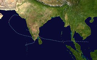
The 2005 North Indian Ocean cyclone season caused much devastation and many deaths in Southern India despite the storms’ weakness. The basin covers the Indian Ocean north of the equator as well as inland areas, sub-divided by the Arabian Sea and the Bay of Bengal. Although the season began early with two systems in January, the bulk of activity was confined from September to December. The official India Meteorological Department tracked 12 depressions in the basin, and the unofficial Joint Typhoon Warning Center (JTWC) monitored two additional storms. Three systems intensified into a cyclonic storm, which have sustained winds of at least 63 km/h (39 mph), at which point the IMD named them.

<span class="mw-page-title-main">1992 North Indian Ocean cyclone season</span>

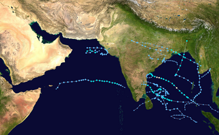
The 1992 North Indian Ocean cyclone season was unofficially the most active year on record for the basin, with 10 tropical storms developing, according to the Joint Typhoon Warning Center (JTWC). There are two main seas in the North Indian Ocean – the Bay of Bengal to the east of the Indian subcontinent – and the Arabian Sea to the west of India. The official Regional Specialized Meteorological Centre in this basin is the India Meteorological Department (IMD), while the JTWC releases unofficial advisories. An average of four to six storms form in the North Indian Ocean every season with peaks in May and November. Cyclones occurring between the meridians 45°E and 100°E are included in the season by the IMD.

<span class="mw-page-title-main">Timeline of the 2007 North Indian Ocean cyclone season</span>

Below is a timeline of the 2007 North Indian Ocean cyclone season, documenting major events with regards to tropical cyclone formation, strengthening, weakening, landfall, extratropical transition, as well as dissipation. The 2007 North Indian Ocean cyclone season was an ongoing event in the annual cycle of tropical cyclone formation.

<span class="mw-page-title-main">2000 North Indian Ocean cyclone season</span> Cyclone season in the North Indian ocean

The 2000 North Indian Ocean cyclone season was fairly quiet compared to its predecessor, with all of the activity originating in the Bay of Bengal. The basin comprises the Indian Ocean north of the equator, with warnings issued by the India Meteorological Department (IMD) in New Delhi. There were six depressions throughout the year, of which five intensified into cyclonic storms – tropical cyclones with winds of 65 mph (105 km/h) sustained over 3 minutes. Two of the storms strengthened into a Very Severe Cyclonic Storm, which has winds of at least 120 km/h (75 mph), equivalent to a minimal hurricane. The Joint Typhoon Warning Center (JTWC) also tracked storms in the basin on an unofficial basis, estimating winds sustained over 1 minute.

<span class="mw-page-title-main">1999 North Indian Ocean cyclone season</span> Cyclone season in the North Indian ocean

The 1999 North Indian Ocean cyclone season was an event in the annual cycle of tropical cyclone formation. The North Indian Ocean cyclone season has no official bounds, but cyclones tend to form between April and December, with peaks in May and November. These dates conventionally delimit the period of each year when most tropical cyclones form in the northern Indian Ocean.

<span class="mw-page-title-main">Timeline of the 2008 North Indian Ocean cyclone season</span>

The 2008 North Indian Ocean cyclone season officially ran throughout the year during 2008, with the first depression forming on April 27. The timeline includes information that was not operationally released, meaning that information from post-storm reviews by the Joint Typhoon Warning Center (JTWC), and the India Meteorological Department (IMD), such as information on a storm that was not operationally warned on. This timeline documents all the storm formations, strengthening, weakening, landfalls, extratropical transitions, as well as dissipation's during the 2008 North Indian Ocean cyclone season.

<span class="mw-page-title-main">1993 North Indian Ocean cyclone season</span> Cyclone season in the North Indian Ocean in 1993

The 1993 North Indian Ocean cyclone season was the least active on record in the basin, with only four tropical disturbances. There are two main seas in the North Indian Ocean – the Bay of Bengal to the east of the Indian subcontinent and the Arabian Sea to the west. The India Meteorological Department (IMD) issued advisories for the systems in its official capacity as the local Regional Specialized Meteorological Center, while the Joint Typhoon Warning Center also issued advisories for two of the storms on an unofficial basis. Of the five disturbances tracked by the IMD, two intensified into cyclonic storms.

<span class="mw-page-title-main">1994 North Indian Ocean cyclone season</span>

The 1994 North Indian Ocean cyclone season was a below-average year in which eight tropical cyclones affected seven countries bordering the North Indian Ocean. The India Meteorological Department tracks all tropical cyclones in the basin, north of the equator. The first system developed on March 21 in the Bay of Bengal, the first March storm in the basin since 1938. The second storm was the most powerful cyclone of the season, attaining maximum sustained winds of 215 km/h (135 mph) in the northern Bay of Bengal. Making landfall near the border of Bangladesh and Myanmar, the cyclone killed 350 people and left US$125 million in damage.

<span class="mw-page-title-main">1987 North Indian Ocean cyclone season</span>

The 1987 North Indian Ocean cyclone season was part of the annual cycle of tropical cyclone formation. The season has no official bounds but cyclones tend to form between April and December. These dates conventionally delimit the period of each year when most tropical cyclones form in the northern Indian Ocean. There are two main seas in the North Indian Ocean—the Bay of Bengal to the east of the Indian subcontinent and the Arabian Sea to the west of India. The official Regional Specialized Meteorological Centre in this basin is the India Meteorological Department (IMD), while the Joint Typhoon Warning Center (JTWC) releases unofficial advisories. An average of five tropical cyclones form in the North Indian Ocean every season with peaks in May and November. Cyclones occurring between the meridians 45°E and 100°E are included in the season by the IMD.

<span class="mw-page-title-main">2009 North Indian Ocean cyclone season</span> North Indian Ocean tropical cyclone season

The 2009 North Indian Ocean cyclone season was an event in the annual cycle of tropical cyclone formation. The North Indian Ocean cyclone season has no official bounds, but cyclones tend to form between April and December, with peaks in May and November. These dates conventionally delimit the period of each year when most tropical cyclones form in the northern Indian Ocean.

<span class="mw-page-title-main">1977 North Indian Ocean cyclone season</span> Tropical cyclone season

The 1977 North Indian Ocean cyclone season was part of the annual cycle of tropical cyclone formation. The season has no official bounds but cyclones tend to form between April and December. These dates conventionally delimit the period of each year when most tropical cyclones form in the northern Indian Ocean. There are two main seas in the North Indian Ocean—the Bay of Bengal to the east of the Indian subcontinent and the Arabian Sea to the west of India. The official Regional Specialized Meteorological Centre in this basin is the India Meteorological Department (IMD), while the Joint Typhoon Warning Center (JTWC) releases unofficial advisories. An average of five tropical cyclones form in the North Indian Ocean every season with peaks in May and November. Cyclones occurring between the meridians 45°E and 100°E are included in the season by the IMD.

<span class="mw-page-title-main">1984 North Indian Ocean cyclone season</span>

The 1984 North Indian Ocean cyclone season was part of the annual cycle of tropical cyclone formation. The season has no official bounds but cyclones tend to form between April and December. These dates conventionally delimit the period of each year when most tropical cyclones form in the northern Indian Ocean. There are two main seas in the North Indian Ocean—the Bay of Bengal to the east of the Indian subcontinent and the Arabian Sea to the west of India. The official Regional Specialized Meteorological Centre in this basin is the India Meteorological Department (IMD), while the Joint Typhoon Warning Center (JTWC) releases unofficial advisories. An average of five tropical cyclones form in the North Indian Ocean every season with peaks in May and November. Cyclones occurring between the meridians 45°E and 100°E are included in the season by the IMD.

<span class="mw-page-title-main">2001 Gujarat cyclone</span> North Indian cyclone in 2001

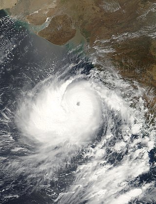
The 2001 Gujarat cyclone was the third strongest tropical cyclone, in terms of barometric pressure, to form in the Arabian Sea on record; only Cyclones Gonu in 2007 and Kyarr in 2019 were stronger. The storm originated from a tropical disturbance that formed east of Somalia on May 18. Over the following few days, the system gradually organized into a tropical depression. Tracking eastward, towards the coastline of southwestern India, the storm slowly intensified. Shortly before reaching shore, the system turned north and later west, away from land. After taking this turn, the storm intensified into a very severe cyclonic storm, attaining its peak intensity on May 24 with winds of 215 km/h and a barometric pressure of 932 mbar (hPa). At the time, this ranked the cyclone as the strongest known storm in the Arabian Sea.

<span class="mw-page-title-main">1998 Gujarat cyclone</span> North Indian cyclone in 1998

The 1998 Gujarat cyclone was a catastrophic tropical cyclone that killed at least 1,000 people in India, mainly in the state of Gujarat.

<span class="mw-page-title-main">2012 North Indian Ocean cyclone season</span> North Indian Ocean tropical cyclone season

The 2012 North Indian Ocean cyclone season was a very inactive season. The season had a very late start, with the first system forming in October. During the season, only five systems formed, of which only two became cyclonic storms. Both the storms made landfall, and they, along with the deep depressions, were responsible for 128 deaths and economic losses worth at least $56.7 million.

<span class="mw-page-title-main">2013 North Indian Ocean cyclone season</span> North Indian Ocean tropical cyclone season

The 2013 North Indian Ocean cyclone season was an event in the annual cycle of tropical cyclone formation, in which tropical cyclones formed in the North Indian Ocean and Arabian Sea. The season had no official bounds, but cyclones typically formed between May and December, with the peak from October to November. These dates conventionally delimit the period of each year when most tropical cyclones form in the northern Indian Ocean.

<span class="mw-page-title-main">2016 North Indian Ocean cyclone season</span> North Indian Ocean tropical cyclone season

The 2016 North Indian Ocean cyclone season was an event in the annual cycle of tropical cyclone formation. It was the deadliest season since 2010, killing more than 400 people. The season was an average one, seeing four named storms, with one further intensifying into a very severe cyclonic storm. The first named storm, Roanu, developed on 19 May while the season's last named storm, Vardah, dissipated on 18 December. The North Indian Ocean cyclone season has no official bounds, but cyclones tend to form between April and December, with the two peaks in May and November. These dates conventionally delimit the period of each year when most tropical cyclones form in the northern Indian Ocean.

<span class="mw-page-title-main">2020 North Indian Ocean cyclone season</span> North Indian Ocean tropical cyclone season

The 2020 North Indian Ocean cyclone season was the costliest North Indian Ocean cyclone season on record, mostly due to the devastating Cyclone Amphan. The North Indian Ocean cyclone season has no official bounds, but cyclones tend to form between April and November, with peaks in late April to May and October to November. These dates conventionally delimit the period of each year when most tropical cyclones form in the northern Indian Ocean. The season began on May 16 with the designation of Depression BOB 01 in the Bay of Bengal, which later became Amphan. Cyclone Amphan was the strongest storm in the Bay of Bengal in 21 years and would break Nargis of 2008's record as the costliest storm in the North Indian Ocean. The season concluded with the dissipation of Cyclone Burevi on December 5. Overall, the season was slightly above average, seeing the development of five cyclonic storms.

<span class="mw-page-title-main">2022 North Indian Ocean cyclone season</span> Tropical cyclone season

The 2022 North Indian Ocean cyclone season was an event in the annual cycle of tropical cyclone formation. It was an above-average season in terms of depressions and average in terms of deep depressions, but slightly below average in terms of cyclonic storms. It was also the least deadly North Indian Ocean cyclone season since 1988, according to official data. The season's strongest tropical cyclone was Cyclone Asani, with maximum wind speeds of 100 km/h and a minimum barometric pressure of 982 hPa. The North Indian Ocean cyclone season has no official bounds, but cyclones tend to form between April and December, with the peak from May to November. These dates conventionally delimit the period of each year when most tropical cyclones form in the northern Indian Ocean.

<span class="mw-page-title-main">Cyclone Hikaa</span> North Indian Ocean tropical cyclone in 2019

Very Severe Cyclonic Storm Hikaa was a tropical cyclone that struck eastern Oman in September 2019. The third named storm of the 2019 North Indian Ocean cyclone season, Hikaa formed on September 22 west of India in the Arabian Sea. The storm reached peak intensity on September 24, with maximum sustained winds estimated over 140 km/h (85 mph). Later that day, the storm made landfall in eastern Oman south of Duqm, and quickly dissipated over the Arabian Peninsula. The name Hikaa was named by Maldives, which refers to the 'scorpion' in Maldivian.

References

  1. Staff Writer. "IMD Cyclone Warning Services: Tropical Cyclones". India Meteorological Department. Archived from the original on 4 November 2008. Retrieved October 21, 2008.
  2. Staff Writer (January 2009). "Report on Cyclonic Disturbances Over the North Indian During 2008". India Meteorological Department. Archived from the original (PDF) on May 29, 2009. Retrieved May 17, 2009.
  3. National Oceanic and Atmospheric Administration (2009). "Tracks for All Northern Hemisphere Tropical Cyclones". World Meteorological Organization. Retrieved February 9, 2009.
  4. 1 2 3 4 5 6 Joint Typhoon Warning Center (1999). "Tropical Cyclone 01B Preliminary Report" (PDF). World Meteorological Organization. Archived from the original (PDF) on June 7, 2011. Retrieved February 8, 2009.
  5. 1 2 3 4 Joint Typhoon Warning Center (1999). "Tropical Cyclone 02A Preliminary Report" (PDF). World Meteorological Organization. Archived from the original (PDF) on June 7, 2011. Retrieved February 9, 2009.
  6. 1 2 3 4 5 Joint Typhoon Warning Center (1999). "Tropical Cyclone 03A Preliminary Report" (PDF). World Meteorological Organization. Archived from the original (PDF) on June 7, 2011. Retrieved February 9, 2009.
  7. 1 2 3 4 5 6 7 8 Gary Padgett (November 29, 1998). "Monthly Tropical Cyclone Summary for October 1998". Typhoon 2000. Retrieved February 9, 2009.
  8. 1 2 3 Joint Typhoon Warning Center (1999). "Tropical Cyclone 04A Preliminary Report" (PDF). World Meteorological Organization. Archived from the original (PDF) on June 7, 2011. Retrieved February 9, 2009.
  9. 1 2 3 Joint Typhoon Warning Center (1999). "Tropical Cyclone 05A Preliminary Report" (PDF). World Meteorological Organization. Archived from the original (PDF) on June 7, 2011. Retrieved February 9, 2009.
  10. 1 2 3 4 5 Joint Typhoon Warning Center (1999). "Tropical Cyclone 06B Preliminary Report" (PDF). World Meteorological Organization. Archived from the original (PDF) on June 7, 2011. Retrieved February 9, 2009.
  11. 1 2 Joint Typhoon Warning Center (1999). "Tropical Storm Chip Preliminary Report" (PDF). World Meteorological Organization. Archived from the original (PDF) on June 7, 2011. Retrieved February 9, 2009.
  12. 1 2 3 4 5 6 7 Joint Typhoon Warning Center (1999). "Tropical Cyclone 07B Preliminary Report" (PDF). World Meteorological Organization. Archived from the original (PDF) on June 7, 2011. Retrieved February 9, 2009.
  13. 1 2 3 4 Joint Typhoon Warning Center (1999). "Tropical Cyclone 08A Preliminary Report" (PDF). World Meteorological Organization. Archived from the original (PDF) on June 7, 2011. Retrieved February 9, 2009.
  14. 1 2 3 4 5 6 Gary Padgett (June 6, 1998). "Monthly Tropical Cyclone Summary for May 1998". Typhoon 2000. Retrieved February 8, 2009.
  15. 1 2 3 4 5 6 7 8 9 10 "IMD Best Tracks Data ( 1990 - 2008 )". India Meteorological Department. 2009. Archived from the original on November 16, 2009. Retrieved July 16, 2009.
  16. 1 2 3 Peter Rees-Gildea (May 25, 1998). "Bangladesh: Cyclone Information Bulletin No. 3" (PDF). Operations Fundraising and Reporting Department. Archived (PDF) from the original on 14 February 2009. Retrieved February 9, 2009.
  17. Office for the Coordination of Humanitarian Affairs (May 25, 1998). "Bangladesh: Cyclone Situation Report No. 2". United Nations. Archived from the original on March 16, 2005. Retrieved February 8, 2009.
  18. Office for the Coordination of Humanitarian Affairs (May 19, 1998). "Bangladesh: Cyclone Situation Report No. 1". United Nations. Archived from the original on March 16, 2005. Retrieved February 8, 2009.
  19. Staff Writer (May 21, 1998). Thousands return home in wake of killer cyclone in Bangladesh Deutsche Presse-Agentur
  20. 1 2 Nizam Ahmed (May 20, 1998). "Chittagong — Bangladesh storm kills 26, injures more than 100". Reuters. Retrieved May 9, 2009.
  21. International Federation of Red Cross and Red Crescent Societies (May 20, 1998). "Bangladesh: Cyclone Information Bulletin Number 2" (PDF). United Nations. Archived (PDF) from the original on 15 May 2009. Retrieved May 9, 2009.
  22. "1998 Best Track from the IMD". India Meteorological Department. July 14, 2009. Archived from the original on December 5, 2010. Retrieved July 16, 2009.
  23. 1 2 3 4 5 6 Gary Padgett (July 14, 1998). "Monthly Tropical Cyclone Summary for June 1998". Typhoon 2000. Retrieved February 9, 2009.
  24. Staff Writer (December 29, 1998). "1998 Natural Catastrophes: Top 10". Munich Re. Archived from the original on February 10, 2008. Retrieved December 8, 2015.
  25. 1 2 3 Rawat, Mukesh (2019-06-13). "Cyclone Vayu spares Gujarat: 21 yrs ago, a cyclone rained death, killed thousands in state". India Today. Retrieved 2019-06-14.
  26. Zschau, Jochen; Andreas N. Küppers (2003). Early warning systems for natural disaster reduction. Springer. p. 200. ISBN   3-540-67962-6.
  27. Office for the Coordination of Humanitarian Affairs (June 10, 1998). "India: Cyclone Situation Report No. 1". United Nations. Archived from the original on March 16, 2005. Retrieved February 9, 2009.
  28. Office for the Coordination of Humanitarian Affairs (June 11, 1998). "India: Cyclone Situation Report No. 2". United Nations. Archived from the original on March 16, 2005. Retrieved February 9, 2009.
  29. 1 2 "Insurance companies lose Rs 1,300 crore in Gujarat cyclone". Indian Express. July 3, 1998. Archived from the original on May 28, 2009. Retrieved May 22, 2009.
  30. 1 2 3 Office for the Coordination of Humanitarian Affairs (June 19, 1998). "India: Cyclone Situation Report No. 4". United Nations. Archived from the original on March 16, 2005. Retrieved February 9, 2009.
  31. Office for the Coordination of Humanitarian Affairs (March 3, 1999). "India — Cyclone — June 1998 Contributions Report". ReliefWeb. Archived from the original on October 19, 2007. Retrieved May 8, 2009.
  32. Gary Padgett (October 26, 1998). "Monthly Tropical Cyclone Summary for September 1998". Typhoon 2000. Retrieved February 9, 2009.
  33. Staff Writer (October 17, 1998). 250 Missing Hindustan Times.
  34. Staff Writer (October 17, 1998). 250 fishermen missing in Indian storm: report Agence France-Presse.
  35. Gary Padgett (November 29, 1998). "Monthly Tropical Cyclone Tracks for October 1998". Typhoon 2000. Retrieved February 9, 2009.
  36. Ashok B. Sharma (October 19, 1998). Southern States Still Under Monsoon Spell. Financial Express.
  37. Staff Writer (October 14, 1998). Heavy rain to continue due to depression. The Hindu.
  38. Staff Writer (October 16, 1998). Srisailam power plant under water, shut down. The Hindu.
  39. Staff Writer (October 17, 1998). Krishna rising, thousands evacuated. The Hindu.
  40. "IMD TCR 1998" (PDF). India Meteorological Department : 40–44. February 1999.
  41. Staff Writer (October 30, 1998). Depression may bring rain; storm unlikely The Independent.
  42. 1 2 3 4 5 6 7 Gary Padgett (1998). "Monthly Tropical Cyclone Summary for November 1998". Typhoon 2000. Retrieved February 9, 2009.
  43. 1 2 Staff Writer (November 16, 1998). Storm crosses coast near Vizag, relief teams rushed The Hindu
  44. Staff Writer (November 16, 1998). "India: Six die as cyclone batters north coastal Andhra". PTI news agency. Retrieved May 8, 2009.
  45. 1 2 Staff Writer (November 16, 1998). "AP cyclone kills 6". Indian Express Newspapers. Retrieved May 8, 2009.
  46. Staff Writer (November 26, 1998). "Earthwatch: A Diary of the Planet". Los Angeles Times. Retrieved February 9, 2009.
  47. UNI (November 16, 1998). "Cyclonic storm crosses Andhra coast, claims two lives". Rediff. Retrieved May 8, 2009.
  48. V. Sanil Kumar, K. Ashok Kumar and N. S. N. Raju (January 31, 2004). "Wave characteristics off Visakhapatnam coast during a cyclone" (PDF). Ocean Engineering Division, National Institute of Oceanography. Retrieved May 8, 2009.
  49. Staff Writer (November 17, 1998). Officials warn typhoon building in the South Emerging Markets Datafile.
  50. Staff Writer (January 2008). "Field Investigation on the Impact of Cyclone Sidr in the Coastal Region of Bangladesh" (PDF). Bangladesh University of Engineering and Technology. Archived from the original (PDF) on 2009-03-19. Retrieved February 9, 2009.
  51. Office for the Coordination of Humanitarian Affairs (December 18, 1998). "Bangladesh : Cyclone : 1998/11". Asian Disaster Reduction Center. Archived from the original on July 22, 2011. Retrieved May 9, 2009.
  52. Office for the Coordination of Humanitarian Affairs (November 24, 1998). "Bangladesh: Cyclone Situation Report No. 1". United Nations. Archived from the original on March 17, 2005. Retrieved February 8, 2009.
  53. Oxfam (February 5, 1999). "Emergency Bulletin: India". ReliefWeb. Retrieved February 9, 2009.
  54. 1 2 3 4 Gary Padgett (1999). "Monthly Tropical Cyclone Summary for December 1998". Typhoon 2000. Retrieved February 9, 2009.
  55. Staff Writer (December 26, 1998). "Minister sends experts to check Wanakbori weir". Indian Express Newspapers. Retrieved April 15, 2009.