2001 southern Peru earthquake

Last updated
2001 southern Peru earthquake
2001 2001 southern Peru earthquake intesity map.jpg
South America laea relief location map.jpg
Blue pog.svg
Arica
Blue pog.svg
Coquimbo
Bullseye1.png
UTC  time2001-06-23 20:33:14
ISC  event 1893467
USGS-ANSS ComCat
Local dateJune 23, 2001 (2001-06-23)
Local time15:33
Magnitude8.4 Mw [1]
Depth32 km (20 mi) [1]
Epicenter 16°22′S73°29′W / 16.36°S 73.48°W / -16.36; -73.48 [1]
Type Megathrust
Areas affected Peru
Max. intensity VIII (Severe) [2]
Tsunami7 m (23 ft) [3]
Casualties74–145 dead
2,687–2,713 injured [2]

The 2001 southern Peru earthquake occurred at 20:33:15 UTC (15:33:15 local time) on June 23 with a moment magnitude of 8.4 and a maximum Mercalli intensity of VIII (Severe). The quake affected the Peruvian regions of Arequipa, Moquegua and Tacna. It was the most devastating earthquake in Peru since the catastrophic 1970 Ancash earthquake and globally the largest earthquake since the 1965 Rat Islands earthquake.

Contents

Tectonic setting

Peru lies above the destructive boundary where the Nazca Plate is being subducted beneath the South American Plate along the line of the Peru–Chile Trench. [2] The two plates are converging towards each other at a rate of about 78mm or 3 inches per year. [4] Southwestern Peru has a history of very large earthquakes. The June 23 shock originated just southeast of the source of a magnitude 7.7 earthquake that occurred in 1996, and it appears to have involved rupture of part of the plate boundary segment that produced an earthquake of magnitude approximately 9.0 in 1868. The 1868 earthquake was destructive in towns that were heavily damaged in the June 23 earthquake. The 1868 earthquake produced a tsunami that killed thousands of people along the South American coast and also caused damage in Hawaii and the only recorded tsunami deaths in New Zealand. [2] [5]

Earthquake

The earthquake occurred as a result of thrust faulting along the plate boundary interface. The initial onset consisted of two events separated by about 6 seconds. It was followed by at least one larger complex event occurring about 40 seconds later. [2] The rupture area as determined from the distribution of aftershocks was 320 km x 100 km. The rupture propagated unilaterally from the hypocenter towards the southeast. [6] The earthquake resulting in many instances of ground failure effects. These ground failure effects included landslides, collapsed drainage banks, ground cracking and more. These failures can have long term effects on the landscape and the local habitats. [7]

Tsunami

The size and location of the earthquake caused a local tsunami in Peru as well as smaller tsunamis in other countries and on other continents. [8] The magnitude of the local tsunami that was caused by the earthquake was measured as Mt=8.2 by the Earthquake Research Institute and waves from the local tsunami were recorded to be 5 to 8 meters high. [9] The local tsunami that occurred in Peru caused great damage to a 20 km section of coastline located in the municipality of Camana and as a result over 3,000 structures were destroyed or damaged, around 5,000 acres of farmland were covered in sand. Although great damage occurred to structures in the area, the loss of human life could have been much greater had this event occurred in the summer when the area is highly populated by tourists. Another factor that greatly reduced the loss of life was the fact that a majority of the population is knowledgeable about earthquakes and their resulting tsunamis. Many of the residents felt the earthquake as well as noticed the receding water and had the ability to evacuate to higher ground to avoid the resulting tsunami. [10] The largest non-local tsunamis occurred in Chile and waves reached heights of 257 cm. Other areas that also recorded tsunamis associated with the earthquake include the Galapagos Islands, Mexico, California, Hawaii, Alaska, Fiji, Samoan Islands, Japan, New Zealand, Tonga, and Russia. [8]

Damage and casualties

At least 74 people were killed, including 26 killed by a tsunami. At least 2,687 were injured, 17,510 homes were destroyed and 35,549 homes damaged in the Arequipa-Camana-Tacna area. An additional 64 people were missing due to the tsunami in the Camana-Chala area. Landslides blocked highways in the epicentral area. Many of the historic buildings in Arequipa were damaged or destroyed, including the left tower of the Basilica Cathedral of Arequipa. [11] Some people were injured and damage was reported in the Arica, Chile area. It was felt in Arica, Iquique, Calama and Tocopilla, Chile. The quake was also felt strongly in much of southern Peru and northern Chile and also in Bolivia. Tsunami runup heights near Camana were estimated from field evidence to have reached approximately 7m at some locations; at other locations, the tsunami inundation distance extended more than 1 km inland from the coast. Tsunami wave heights (peak-to-trough) recorded from selected tide stations: 2.5m at Arica; 1.5m at Iquique; 1.0m at Coquimbo, Chile. [2]

Relief

The Government of Peru and the Peruvian Civil Defense Institute (INDECI) were at the center of relief efforts after the earthquake and tsunami. At least 36,000 homes were damaged with another minimum of 24,000 homes destroyed. This was particularly concerning due to the weather being able to go below freezing temperatures in some of the areas. After a state of emergency was declared in some affected areas on the 24th of June, International assistance was requested by the Government of Peru and a total of $215 million was allocated with $70 million going to relief and $140 million going to reconstruction. Most of the funds were gotten from loans and were split between the different ministries of Government to provide aid and relief efforts. Multilateral Organizations including UNICEF, the United Nations and the International Federation of Red Cross and Red crescent societies. In addition numerous governments provided aid in form of either resources or money. These governments include but are not limited to Argentina, Brazil, Chile, Colombia, Ecuador, Panama, Uruguay, Venezuela, Belgium, France, USA, Canada, Germany, Italy, Japan, Norway, Spain, Sweden, Switzerland, the European Union Humanitarian Aid Office and the United Kingdom. [12]

See also

Related Research Articles

The Peru–Chile Trench, also known as the Atacama Trench, is an oceanic trench in the eastern Pacific Ocean, about 160 kilometres (99 mi) off the coast of Peru and Chile. It reaches a maximum depth of 8,065 m (26,460 ft) below sea level in Richards Deep and is approximately 5,900 km (3,666 mi) long; its mean width is 64 km (40 mi) and it covers an expanse of some 590,000 km2 (230,000 sq mi).

<span class="mw-page-title-main">Tacna</span> Place in Peru

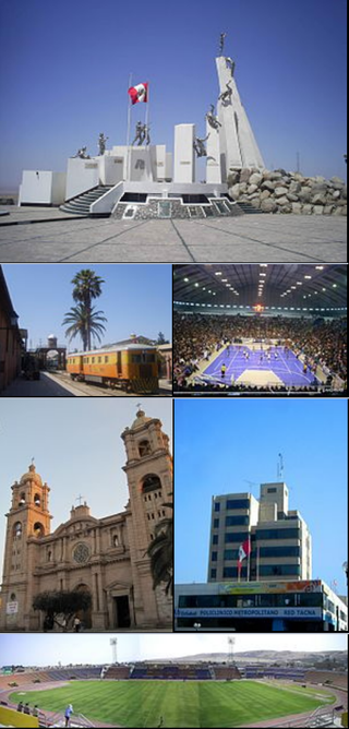
Tacna, officially known as San Pedro de Tacna, is a city in southern Peru and the regional capital of the Tacna Region. A very commercially active city, it is located only 35 km (22 mi) north of the border with Arica y Parinacota Region from Chile, inland from the Pacific Ocean and in the valley of the Caplina River. It is Peru's tenth most populous city.

<span class="mw-page-title-main">2005 Nias–Simeulue earthquake</span> 2005 earthquake in Sumatra, Indonesia

The 2005 Nias–Simeulue earthquake occurred on 28 March off the west coast of northern Sumatra, Indonesia. At least 915 people were killed, mostly on the island of Nias. The event caused panic in the region, which had already been devastated by the massive tsunami triggered by the 2004 Indian Ocean earthquake, but this earthquake generated a relatively small tsunami that caused limited damage. It was the third most powerful earthquake since 1965 in Indonesia.

<span class="mw-page-title-main">Aleutian Trench</span> An oceanic trench along the southern coastline of Alaska and the Aleutian islands

The Aleutian Trench is an oceanic trench along a convergent plate boundary which runs along the southern coastline of Alaska and the Aleutian islands. The trench extends for 3,400 kilometres (2,100 mi) from a triple junction in the west with the Ulakhan Fault and the northern end of the Kuril–Kamchatka Trench, to a junction with the northern end of the Queen Charlotte Fault system in the east. It is classified as a "marginal trench" in the east as it runs along the margin of the continent. The subduction along the trench gives rise to the Aleutian Arc, a volcanic island arc, where it runs through the open sea west of the Alaska Peninsula. As a convergent plate boundary, the trench forms part of the boundary between two tectonic plates. Here, the Pacific Plate is being subducted under the North American Plate at a dip angle of nearly 45°. The rate of closure is 7.5 centimetres (3 in) per year.

<span class="mw-page-title-main">2007 Peru earthquake</span> 2007 earthquake and tsunami centered off the coast of Ica Department, Peru

The 2007 Peru earthquake, which measured 8.0 on the moment magnitude scale, hit the central coast of Peru on August 15 at 23:40:57 UTC and lasted two minutes. The epicenter was located 150 km (93 mi) south-southeast of Lima at a depth of 39 km (24 mi). At least 595 people died and over 2,290 people were injured.

<span class="mw-page-title-main">2007 Tocopilla earthquake</span>

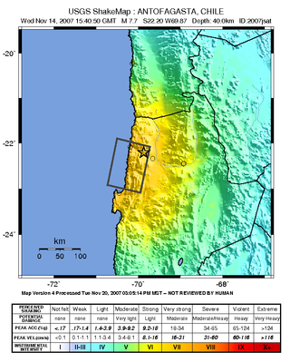
The 2007 Tocopilla earthquake occurred on November 14 at 12:40:50 local time. Its epicenter was located between Quillagua and Tocopilla, affecting the Tarapacá and the Antofagasta regions in northern Chile. The earthquake had a moment magnitude of 7.7 and lasted about 3 minutes and 35 seconds. Seventeen aftershocks of magnitude greater than 5.3, including one of magnitude 7.1 and two others of magnitude 6.3 or higher, were recorded. The Pacific Tsunami Warning Center issued a tsunami warning, stating a tsunami had been generated; after one hour, this warning was cancelled. The earthquake was felt from Santiago, 1,245 km south from the epicenter, to La Paz, about 700 km north-northeast.

The 1994 Bolivia earthquake occurred on June 9, 1994. The epicenter was located in a sparsely populated region in the Amazon jungle, about 200 miles from La Paz.

<span class="mw-page-title-main">2000 Enggano earthquake</span> Earthquake affecting Indonesia

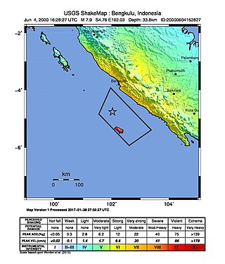
At 23:28 local time on June 4, 2000 southern Sumatra, Indonesia was struck by an earthquake of moment magnitude 7.9 with a maximum Mercalli intensity of VI (Strong). The event occurred off the coast near Enggano Island. There were more than 100 fatalities and up to 2,585 injuries. Over 730 aftershocks shook the area afterwards, one just eleven minutes after the mainshock.

The 1995 Antofagasta earthquake occurred on July 30 at 05:11 UTC with a moment magnitude of 8.0 and a maximum Mercalli intensity of VII. The Antofagasta Region in Chile was affected by a moderate tsunami, with three people killed, 58 or 59 injured, and around 600 homeless. Total damage from the earthquake and tsunami amounted to $1.791 million.

<span class="mw-page-title-main">2010 Chile earthquake</span> Magnitude 8.8 earthquake in Chile on 27 February 2010

The 2010 Chile earthquake and tsunami occurred off the coast of central Chile on Saturday, 27 February at 03:34:12 local time, having a magnitude of 8.8 on the moment magnitude scale, with intense shaking lasting for about three minutes. It was felt strongly in six Chilean regions that together make up about 80 percent of the country's population. According to the United States Geological Survey (USGS) the cities experiencing the strongest shaking—VIII (Severe) on the Mercalli intensity scale (MM)—were Concepción, Arauco, and Coronel. According to Chile's Seismological Service, Concepción experienced the strongest shaking at MM IX (Violent). The earthquake was felt in the capital Santiago at MM VII or MM VIII. Tremors were felt in many Argentine cities, including Buenos Aires, Córdoba, Mendoza, and La Rioja. Tremors were felt as far north as the city of Ica in southern Peru. It is the largest earthquake to hit Chile since the 1960 Valdivia earthquake.

<span class="mw-page-title-main">1868 Arica earthquake</span> Chilean earthquake and Pacific Ocean tsunami

The 1868 Arica earthquake occurred on 13 August 1868, near Arica, then part of Peru, now part of Chile, at 21:30 UTC. It had an estimated magnitude between 8.5 and 9.3. A tsunami in the Pacific Ocean was produced by the earthquake, which was recorded in Hawaii, Japan, Australia, and New Zealand.

The 1730 Valparaíso earthquake occurred at 04:45 local time on July 8. It had an estimated magnitude of 9.1–9.3 and triggered a major tsunami with an estimated magnitude of Mt  8.75, that inundated the lower parts of Valparaíso. The earthquake caused severe damage from La Serena to Chillan, while the tsunami affected more than 1,000 km (620 mi) of Chile's coastline.

The 1877 Iquique earthquake occurred at 21:16 local time on 9 May. It had a magnitude of 8.5 on the surface wave magnitude scale. Other estimates of its magnitude have been as high as 8.9 Mw and 9.0 Mt. It had a maximum intensity of XI (Extreme) on the Mercalli intensity scale and triggered a devastating tsunami. A total of 2,385 people died, mainly in Fiji.

<span class="mw-page-title-main">2010 Pichilemu earthquakes</span> 6.9 and 7.0 MW intraplate earthquakes 2010 in Chile

The 2010 Pichilemu earthquakes, also known as the Libertador O'Higgins earthquakes, were a pair of intraplate earthquakes measuring 6.9 and 7.0 Mw that struck Chile's O'Higgins Region on 11 March 2010 about 16 minutes apart. The earthquakes were centred 15 kilometres (9.3 mi) northwest of the city of Pichilemu.

The 1996 Nazca earthquake occurred on November 12 at 16:59 UTC. The earthquake was located offshore near Nazca, Peru. It has a magnitude of Mw 7.7. Fourteen people were reported dead. Four-thousand houses collapsed and 11,000 were partially damaged. Nazca and Acarí were the most affected cities. Liquefaction was observed in the bed of the Yauca River. The intensity was VIII (Severe) in Nazca. A tsunami was triggered by this earthquake. The recorded peak-to-trough heights of the tsunami were 25 cm in Callao, Peru and 35 cm in Arica, Chile.

The 1942 Peru earthquake occurred on August 24 at 17:50 local time and was located near the border of the departments of Ica and Arequipa, Peru. It had a magnitude of Mw 8.2 or Ms 8.4.

The 2014 Iquique earthquake struck off the coast of Chile on 1 April, with a moment magnitude of 8.2, at 20:46 local time. The epicenter of the earthquake was approximately 95 kilometres (59 mi) northwest of Iquique. The mainshock was preceded by a number of moderate to large shocks and was followed by a large number of moderate to very large aftershocks, including a M7.7 event on 3 April. The megathrust earthquake triggered a tsunami of up to 2.11 metres (6.9 ft) that hit Iquique at 21:05 local time. Similar-sized tsunamis were also reported to have hit the coasts of Pisagua and Arica.

An earthquake measuring Mw 8.0 struck Peru and the surrounding areas on 26 May 2019 at 02:41 local time. It had a maximum perceived intensity of VII on the Modified Mercalli intensity scale in the towns of Yurimaguas and Lagunas. Two people died and a further 30 were injured. It was the strongest earthquake in 2019 by magnitude.

<span class="mw-page-title-main">2021 Mala earthquake</span> 6.0 magnitude earthquake in Mala, Lima, Peru

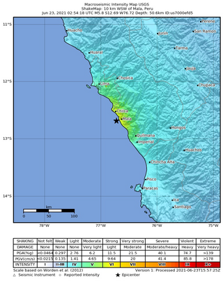
The 2021 Mala earthquake, with a Richter magnitude of 6.0 and moment magnitude of 5.9, struck on June 22, 2021, at 21:54:18 local time (UTC-5) with an epicenter off the coast of Mala in the department of Lima. Following the main event, there were more than 15 aftershocks, with the largest being a magnitude 4.8 event at 07:03 local time on June 23.

The 1604 Arica earthquake is an earthquake that occurred at 1:30 pm on November 24, 1604, offshore Arica, Chile. The estimated magnitude range is 8.0–8.5 Ms and possibly up to 9.0 Mw. It had a destructive tsunami that destroyed Arica and caused major damage at Arequipa. 1,200 km of coastline were affected by the tsunami. The recorded effects of this earthquake are very similar to those for the 1868 Arica event, suggesting a similar magnitude and rupture area of the megathrust between the subducting Nazca Plate and the overriding South American Plate. Tsunami deposits have been identified on the Chatham Islands that are likely to have been caused by a trans-Pacific tsunami caused by the 1604 earthquake.

References

  1. 1 2 3 ISC (2016), ISC-GEM Global Instrumental Earthquake Catalogue (1900–2012), Version 3.0, International Seismological Centre
  2. 1 2 3 4 5 6 USGS. "M 8.4 - 6 km SSW of Atico, Peru". United States Geological Survey.
  3. USGS (September 4, 2009), PAGER-CAT Earthquake Catalog, Version 2008_06.1, United States Geological Survey, archived from the original on 2020-03-13
  4. Curtis L. Edwards, ed. (2002). Atico, Peru Mw8.4 Earthquake of June 23, 2001. Reston, VA: ASCE, TCLEE. ISBN   9780784406618. Archived from the original on 2013-04-14.
  5. Morton, Jamie (13 August 2018). "NZ's only killer tsunami: What it means today". NZ Herald. ISSN   1170-0777 . Retrieved 2018-08-13.
  6. Giovanni, M.K.; Beck, S.L.; Wagner, L. (2002). "The June 23, 2001 Peru earthquake and the southern Peru subduction zone". Geophysical Research Letters. 29 (21): 2018. Bibcode:2002GeoRL..29.2018G. doi:10.1029/2002GL015774. S2CID   28025654.
  7. Keefer, David K.; Moseley, Michael E. (2004-07-27). "Southern Peru desert shattered by the great 2001 earthquake: Implications for paleoseismic and paleo-El Niño–Southern Oscillation records". Proceedings of the National Academy of Sciences. 101 (30): 10878–10883. doi: 10.1073/pnas.0404320101 . ISSN   0027-8424. PMC   491987 . PMID   15263069.
  8. 1 2 Service, National Weather. "National Weather Service - Tsunami Hazards". www.tsunami.gov. Retrieved 2021-12-01.
  9. "Preliminary Analysis of the Tsunami Generated by the June 23, 2001 Peru Earthquake". www.usgs.gov. Retrieved 2021-12-01.
  10. Dengler, L. (2001-12-01). "Impacts of the June 23, 2001 Peru Tsunami". AGU Fall Meeting Abstracts. 2001: S52A–0617. Bibcode:2001AGUFM.S52A0617D.
  11. "Initial Report on 23 June 2001 Arequipa, Peru Earthquake" (PDF). eeri.org. July 3, 2001. Retrieved November 30, 2021.
  12. "Peru - Earthquake Fact Sheet #6, Fiscal Year (FY) 2001 - Peru". ReliefWeb. Retrieved 2021-12-01.