Storms traveled across southwestern Australia in March 2010
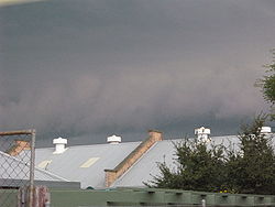
A shelf cloud approaching Perth city looking over City Farm at 3:53pm local time
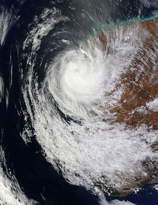
The 2010 Western Australian storms were a series of storms that travelled over southwestern Western Australia on 21 and 22 March 2010. One of the more intense storm cells passed directly over the capital city of Perth between 3:30pm and 5:00pm on Monday 22 March 2010. It is the costliest natural disaster in Western Australian history, with the damage bill estimated at $1.08 billion.[1]
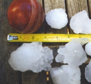
The storms brought extensive hail, strong winds and heavy rain, causing extensive damage to vehicles, property and trees, and flash flooding, as well as the first significant rainfall in Perth since 20 November 2009.[2] The hail stones are the largest ever known to have occurred in Perth and were around 3–6cm (1.2–2.4in) in diameter,[3] which caused extensive damage to property across the city,[4] including schools, hospitals, universities and power infrastructure. Wind gusts were recorded at around 120km/h (75mph).[2] At the peak, around 158,000 homes in Perth, Mandurah and Bunbury lost electric power.[2][5] Telephone lines were cut to thousands of homes until the next day, and the storms led to an estimated A$200 million worth of insurance claims within three days, with $70 million within the first 24 hours.[6] It was identified as the most expensive natural disaster in Western Australia's history,[7] and was declared a natural disaster by the Premier, Colin Barnett, allowing federal and state funds to be used for disaster relief.[8][9]
The storm brought an end to a lengthy dry spell in Perth, with 40.2 millimetres (1.58in) of rain falling at Mount Lawley – the fifth highest daily rainfall recorded for a March day in Perth. Over half of this fell in just 10 minutes.[3] This was the first significant rainfall since 20 November 2009; only 0.2 millimetres (0.01in) had fallen in the entire period. It was similar to storms which struck Melbourne on 6 March 2010.
Storm timeline
During the warmer summer months, low-level surface troughs normally cross over the west coast of Australia, which often leads to isolated thunderstorm development in inland Western Australia, only occasionally reaching the coast (such as on 20 December 2009, when a storm developed south of Perth and gave the city of Mandurah2.8 millimetres (0.11in) of rain for the month). However, on 21 and 22 March 2010, high surface dew points and temperatures combined with a low to the west of WA caused rare northerly winds to occur. This meant any storms that formed would be pushed southwards instead of the normal easterly pattern.
21 March 2010
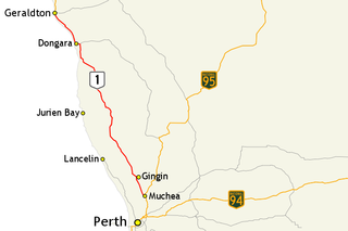
Storms formed in the Geraldton region during the afternoon, putting an end to the city's fourth-longest dry spell, with 14.6 millimetres (0.57in) of rainfall recorded at Geraldton. The township of Badgingarra (halfway between Perth and Geraldton) bore the brunt of storms on both days, receiving 27.6 millimetres (1.09in). Storms also developed in inland parts of the Gascoyne, where Cue got over 80 millimetres (3.1in) of rainfall and Mount Magnet received 57 millimetres (2.2in).
22 March 2010
The Geraldton storm moved out towards the coast during the morning, skipping Perth, but not before putting an end to nearby Mandurah's dry spell with 2.4 millimetres (0.09in) of rainfall and later Bunbury where 9 millimetres (0.35in) fell. Seven pole-top fires cut power to 1,200 homes across both cities.[10]
A severe thunderstorm warning was later declared for the central west (around Geraldton), lower west (including the cities Perth and Mandurah), central Wheatbelt, Great Southern and southern Gascoyne regions of Western Australia at 9.45am. It was amended at 2.30pm to indicate the threat to Perth.
As predicted, storms began to develop in the Jurien Bay area around 2pm, bringing another 36.2 millimetres (1.43in) to an already sodden Badgingarra. At 3pm, the main storm moved over Gingin, dropping the temperature from 26.3°C (79.3°F) at 3.06pm to 21.4°C (70.5°F) at 3.33pm, and delivering 18.2 millimetres (0.72in) to the township. Perth was next in line for the storms, which first hit the northern suburbs around the Cities of Joondalup and Wanneroo, where 62.8 millimetres (2.47in) fell in two hours at the suburb itself. Hailstones with diameters of 3–5cm were reported around suburbs like Osborne Park, Nollamara and Craigie, while 6 centimetres (2.4in) hailstones were measured in the inner Perth suburb of Wembley.
By 4pm, the Perth storm had reached the southern suburbs and damaging wind gusts had been reported at the suburb of Jandakot (96km/h). Jarrahdale, to the southeast of Perth, received 44.2 millimetres (1.74in) in half an hour, exceeding the conditions required for a 1 in 100-year flood in terms of a period from 15 to 30 minutes. However, the storm began to lessen in intensity and become larger, forming a multi-squall line as it moved further south. A second wave of storm activity developed behind the first set, delivering further falls to northern Perth. Around 4.30pm, a severe thunderstorm warning was issued for Mandurah and surrounding areas. However, the storm had begun to move further inland, resulting in no hail reported in Mandurah or Rockingham and 17.4/13.4mm at Garden Island and Mandurah respectively while inland towns such as Dwellingup and Waroona received 30.2 and 26.8mm respectively.
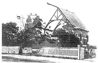
Building damage
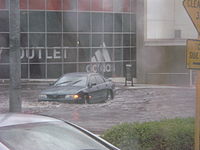
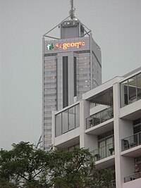
Flash flooding at an intersection in Wellington Street, PerthDamage to a sign on a skyscraper in Perth city caused by hail
Around 12,000 individual insurance claims were made in the 24 hours after the storms. The damage zone was defined by a loop from Geraldton to Mandurah through Cue, Merredin and Katanning. A week after the storm, the damage bill was estimated to have reached A$650 million, and was still climbing, making it the most expensive catastrophe in Western Australian history.[11]
Over 100 people were evacuated from apartments near Kings Park in central Perth after heavy rain cause a large mudslide.[2]
Tens of thousands of cars were damaged by the hail. The cost of fixing the dented panels is high, owing to the hundreds of dents involved, so many of these damaged cars were written off by the insurance companies covering the damage. However, as these vehicles only suffered superficial damage they were often resold by insurance companies once minor repairs were conducted, leaving the dented panels unrepaired.[12]
The storm dropped a lot of large hail on both a major vehicle retail area Osborne Park damaging millions of dollars of new and used cars (both directly[13] and indirectly when buildings were damaged[14]) and on the Kwinana Freeway.[15]
A supercell is a thunderstorm characterized by the presence of a mesocyclone: a deep, persistently rotating updraft. Due to this, these storms are sometimes referred to as rotating thunderstorms. Of the four classifications of thunderstorms, supercells are the overall least common and have the potential to be the most severe. Supercells are often isolated from other thunderstorms, and can dominate the local weather up to 32 kilometres (20 mi) away. They tend to last 2–4 hours.
A severe thunderstorm warning is a type of public warning for severe weather that is issued by weather forecasting agencies worldwide when one or more severe thunderstorms have been detected by Doppler weather radar, observed by weather spotters, or reported by an emergency management agency, law enforcement, or the general public. Unlike a watch, a warning is issued to areas in the direct path of active severe thunderstorms, that are expecting a direct impact typically within an hour. Severe thunderstorms can cause property damage and injury due to large hail, high winds, and flooding due to torrential rainfall. The exact criteria to issue a warning varies from country to country.
Mandurah is a coastal city in the Australian state of Western Australia, situated approximately 72 kilometres (45 mi) south of the state capital, Perth. It is the state's second most populous city, with a population of 90,306.
Brand Highway is a 370-kilometre (230 mi) main highway linking the northern outskirts of Perth to Geraldton in Western Australia. Together with North West Coastal Highway, it forms part of the Western Australian coastal link to the Northern Territory. The highway is a part of Australia's Highway 1, and is for the most part a single carriageway with one lane in each direction.
Severe storms in Australia refers to the storms, including cyclones, which have caused severe damage in Australia. For comparison, a comprehensive list of all damaging storms can be found on the Australian Bureau of Meteorology website.
In early 1961, a series of bushfires burned in the south-west region of Western Australia. The devastating fires burned large areas of forest in and around Dwellingup from 20 to 24 January, at Pemberton and in the Shannon River region between 11 and 15 February, and in the Augusta-Margaret River area in early March. There were also major fires which burned in the Darling Scarp around Kalamunda. The towns of Dwellingup and Karridale were largely destroyed by the fires, as were a number of smaller railway and mill settlements. There was no loss of human life.
Badgingarra is a small town in the Wheatbelt region of Western Australia, about 205 kilometres (127 mi) north of Perth in the Shire of Dandaragan. It lies on the Brand Highway adjacent to the Badgingarra National Park.
Severe weather is any dangerous meteorological phenomenon with the potential to cause damage, serious social disruption, or loss of human life. Types of severe weather phenomena vary, depending on the latitude, altitude, topography, and atmospheric conditions. High winds, hail, excessive precipitation, and wildfires are forms and effects of severe weather, as are thunderstorms, downbursts, tornadoes, waterspouts, tropical cyclones, and extratropical cyclones. Regional and seasonal severe weather phenomena include blizzards (snowstorms), ice storms, and duststorms.
A series of destructive severe thunderstorms struck southeastern Queensland, Australia, on 29 November 1992. The storms produced strong winds, flash flooding and large hailstones in the region, including the capital city of Brisbane. The storms also spawned two of the most powerful tornadoes recorded in Australia, including the only Australian tornado to be given an official 'F4' classification on the Fujita scale and the last violent tornado in Australia until 21 March 2013.
The 1947 Sydney hailstorm was a natural disaster which struck Sydney, Australia, on 1 January 1947. The storm cell developed on the morning of New Year's Day, a public holiday in Australia, over the Blue Mountains, hitting the city and dissipating east of Bondi in the mid-afternoon. At the time, it was the most severe storm to strike the city since recorded observations began in 1792.
Extreme weather events in Melbourne, Australia have occurred on multiple occasions. The city has experienced a number of highly unusual weather events and extremes of weather. An increase in heat waves and record breaking temperatures in the 21st century has led to much discussion over the effects of climate change in the country.
The 2010 Victorian storms were a series of storms that passed through much of the Australian state of Victoria on 6 and 7 March 2010. One of the most severe storms passed directly over Greater Melbourne, bringing lightning, flash flooding, very large hail and strong winds to the state's capital.
Severe Tropical Cyclone Lua affected a sparsely populated region of Western Australia during mid-March 2012. Originating in a broad low pressure area that formed northwest of Australia by 8 March, the storm was plagued by inhibiting wind shear for the duration of its formative stages. However, it gradually organised, and received the name Lua on 13 March. The cyclone meandered for the first several days of its existence, caught between weak and competing steering currents. After the cyclone drifted northwestward, a building ridge of high pressure to the north drove Lua southeastward toward the Pilbara region. Ultimately intensifying into an upper-end Category 3 severe tropical cyclone with maximum sustained 10-minute winds of 155 km/h (96 mph), Lua made landfall near the remote community of Pardoo, about 150 km (93 mi) east of Port Hedland. It steadily weakened as it progressed south over interior Western Australia, diminishing below tropical cyclone status on 18 March.
Severe Tropical Cyclone Olwyn was a strong tropical cyclone that caused extensive damage across the northwestern coast of Western Australia in March 2015. The twelfth tropical low, the sixth named storm and cyclone, and the fourth severe tropical cyclone; Olwyn formed from a weak tropical low over Western Australia on March 8. Olwyn rapidly intensified as it tracked south-southeast, reaching category 3 strength on March 11. The cyclone made landfall near Exmouth on March 13 as a category 3 cyclone, with winds of up to 185 km/h. Olwyn weakened slightly after landfall, but continued to track south-southeast, bringing heavy rain and strong winds to coastal areas.
Perth, the capital city of the state of Western Australia, has a Mediterranean climate, with hot, dry summers and cool, wet winters. February is the hottest month of the year, with an average high of 31.6 °C (88.9 °F), and July is the coldest month of the year, with an average low of 7.9 °C (46.2 °F). 77% of rain in Perth falls between May and September. Perth has an average of 8.8 hours of sunshine per day, which equates to around 3,200 hours of annual sunshine, and 138.7 clear days annually, making it the sunniest capital city in Australia.
Severe Tropical Cyclone Kelvin was a strong tropical cyclone that impacted Western Australia in February 2018, causing moderate damage. The system was first identified as a weak tropical low on the morning of 11 February over the Northern Territory's Tiwi Islands by the Australian Bureau of Meteorology (BoM). The low moved southwestwards over land and emerged over the Indian Ocean near Broome on 16 February. The storm intensified into a Category 1 tropical cyclone on the following day, becoming the sixth named storm of the 2017–18 Australian region cyclone season. Kelvin subsequently moved slowly eastwards and began to rapidly intensify in the hours prior to landfall. On 18 February, the storm crossed the coast along Eighty Mile Beach as a Category 3 severe tropical cyclone on the Australian scale, and a high-end Category 1 hurricane-equivalent cyclone on the Saffir–Simpson scale. Despite being over land, Kelvin weakened at a slow rate over the next few days, and was downgraded to a tropical low on 19 February. The remnant low of the system drifted over the Outback before being last noted by BoM on 21 February.
The July 1968 United Kingdom thunderstorms were the most severe dust fall thunderstorms in the British Isles for over 200 years. A layer of mineral dust blowing north from the Sahara met cold, wet air over the British Isles, resulting in thick, dense clouds and severe thunderstorms across most of England and Wales. These clouds completely blotted out the light in some areas and the rain and hail resulted in property damage and flooding, and at least four people were killed. During the storm, Leeming Bar in North Yorkshire saw 35.7 millimetres (1.41 in) of rain in under 10 minutes – a UK record until 2003.
A Black nor'easter is a persistent and potentially violent north-easterly storm that occurs on the east coast of Australia usually between late spring and early autumn, about two days a year, although not a convection wind, but a storm system that develops offshore which can last several days. This is heralded by the rapid build-up of dense black cloud that can convert to a gale in well under one hour, and also bringing with it a heavy rainfall event usually accompanied by a thunderstorm. This type of storm was first recorded during the 1800s.
Severe storm events in Sydney, New South Wales, Australia are not uncommon and include hailstorms, wind storms, and flash flooding from rain caused by East coast lows, black nor'easters and/or tropical cyclone remnants. East coast lows are low pressure depressions or extratropical cyclones that can bring significant damage by heavy rain, cyclonic winds and huge swells. Sydney is rarely affected by cyclones, although remnants of cyclones do affect the city.
This page is based on this Wikipedia article Text is available under the CC BY-SA 4.0 license; additional terms may apply. Images, videos and audio are available under their respective licenses.